|
Author
Hague, Arnold
Full Title
The Shores of Yellowstone Lake. Geology Sheet XXVII. Monograph XXXII. Yellowstone National Park. U.S. Geological Survey. Charles D. Walcott, Director. 1904. Julius Bien & Co. Lith. N.Y. A.H. Thompson, Geographer. Topography by Frank E. Grove, Philip Sawyer under charge of Frank Tweedy. Suveryed in 1889. Arnold Hague, Geologist in charge. Geology by Walter Harvey Weed.
List No
4252.024
Note
Topography shown in 20-foot contours, overlaid in color with 7 classes of rock types. Legend. Note provided on the survey history and on the geomorphic history of Yellowstone Lake.
Author
Paz Soldan, Mariano Felipe, 1821-1886
Full Title
Linea que representa los temblores sentidos en Arequipa desde hasta 1845. Corte vertical del camino del Pacifico al Huallaga. Corte vertical del camino de Arica al Cuzco. Plano del Pongo de Manseriche. Vista segun el corte vertical. Paz Soldan. Geografia del Peru. Grabado por Delamare, Paris, Calle St. Andre des Arts 45. Paris, Imp. Janson, r. Antne. Dubois, 6. (Paris: Libreria de Augusto Durand, 1865)
List No
4363.068
Note
Lithographed graph, 2 profiles, map and view on sheet. Map shows relief by hachures and landform drawings. Scale of Pongo de Manseriche map (ca. 1:54,000)
Author
[Maw, Henry Lister, Paz Soldan, Mariano Felipe, 1821-1886]
Full Title
Lecho del Rio Amazonas segun los sondeos de Lister Maw. Corte vertical del camino de Lima al Cerro de Pasco. Paz Soldan. Geografia del Peru. Grabado por Delamare, Calle St. Andre des Arts 45, Paris. Imp. Janson - Paris. (Paris: Libreria de Augusto Durand, 1865)
List No
4363.069
Note
Two river profiles and 1 geologic section. The section is hand col.
Author
[Castelnau, Francis, comte de, 1812-1880, Paz Soldan, Mariano Felipe, 1821-1886]
Full Title
Corte geologico de la parte sud del Peru que comprende los Departamentos de Puno, Arequipa, Ica y Lima por El Conde Francisco de Castelnau. Paz Soldan. Geografia del Peru. Grabado por Delamare, calle St. Andre des Arts, 45, Paris. Paris, Imprenta Monrocq, calle Suger, 3. (Paris: Libreria de Augusto Durand, 1865)
List No
4363.071
Note
Lithographed geological section in 4 segments. Hand col. Misnumbered "LXVI."
Author
[Castelnau, Francis, comte de, 1812-1880, Paz Soldan, Mariano Felipe, 1821-1886]
Full Title
Corte geologico de la parte sud del Peru que comprende los Departamentos de Puno, Arequipa, Ica y Lima por El Conde Francisco de Castelnau. Paz Soldan. Geografia del Peru. Grabado por Delamare, Paris, Calle St. Andre des Arts, 45. Paris, Imprenta Monrocq, calle Suger, 3. (Paris: Libreria de Augusto Durand, 1865)
List No
4363.072
Note
Lithographed geological section in 4 segments. Hand col. Misnumbered "LXVII"
Author
[Berghaus, Heinrich, Berghaus, Hermann, Luddecke, R., Rohrbach, C.]
Full Title
Ubersicht der Erde. Bearbeitet v. Dr. R. Luddecke & Dr. C. Rohrbach. Ausgabe 1892. Gotha: Justus Perthes. (On upper margin) I. Abt. Geologie No. VII/VIII. Berghaus' physikal atlas No. 7/8. (to Accompany) Berghaus' Physikalischer Atlas. (Begrundet 1836 durch Heinrich Berghaus) ... Gotha: Justus Perthes. 1892. (insets) Wahrscheinliche Ausdehnung des Festlandes zur Jurazeit (nach Neumayr. (with) Verbreitung der Kohle. (with) Verbreitung der jungen Kettengebirge und des pazifischen u. atlantischen Kustentypus.
List No
4391.018
Note
Color lithograph map of the world with 3 insets. Includes statistical tables and colors explanation.
Author
[Berghaus, Heinrich, Berghaus, Hermann, Luddecke, R., Rohrbach, C.]
Full Title
Europa. Entw. v. Herm. Berghaus 1889, Ausg. 1889. Gest. v. A. Herrmann. Gotha: Justus Perthes. (On upper margin) I. Abt. Geologie No. IX. Berghaus' physikal atlas No. 9. (to Accompany) Berghaus' Physikalischer Atlas. (Begrundet 1836 durch Heinrich Berghaus) ... Gotha: Justus Perthes. 1892. (7 insets).
List No
4391.019
Note
Color lithograph map with 7 insets: Laki (Island) -- Vulcano -- Die Pyrenaeen -- Spitzbergen -- Schonen -- Der Kaukasus -- Gletscher des Adai-Choch. Showing major cities, towns, rivers and river basins. Principal geological features are shown by color or symbols. Relief shown by contours and spot heights. Depth shown by isolines and soundings. Includes table of geologic formations and abbreviations.
Author
[Berghaus, Heinrich, Berghaus, Hermann]
Full Title
Alpenlander. Entw. v. Herm. Berghaus 1889, Ausg. 1890. Gest. v. A. Herrmann. Gotha: Justus Perthes. (On upper margin) I. Abt. Geologie No. X. Berghaus' physikal atlas No. 10. (to Accompany) Berghaus' Physikalischer Atlas. (Begrundet 1836 durch Heinrich Berghaus) ... Gotha: Justus Perthes. 1892. (insets) Aus den Dolomiten n. v. Mojsisovics. (inset profiles) Durchschnitt der Ostalpan (with) Durchschnitt der Westalpen.
List No
4391.020
Note
Color lithograph map. Showing major cities, towns, rivers and river basins. Principal geological features are shown by color or symbols. Relief shown by contours and spot heights. Depth shown by isolines and soundings. Includes table of geologic formations and abbreviations. Prime meridian is Greenwich.
Author
[Berghaus, Heinrich, Berghaus, Hermann, Poppey, K., Grabhein, P.]
Full Title
Asien und Europa. Entw. v. Herm. Berghaus 1887, Ausg. 1889. Gest. v. K. Poppey u. P. Grabhein. Gotha: Justus Perthes. (On upper margin) I. Abt. Geologie No. XI. Berghaus' physikal atlas No. 11. (to Accompany) Berghaus' Physikalischer Atlas. (Begrundet 1836 durch Heinrich Berghaus) ... Gotha: Justus Perthes. 1892. (insets) Japan von Dr. Edm. Naumann, Korea von Dr. C. Gottsche. (with) Indisches Salz-Gebirge. (with) Lavastrom des Asama Jama von J.1783. (with) Java nach F. Junghulm.
List No
4391.021
Note
Color lithograph map. Showing major cities, towns, rivers, lakes and river basins. Principal geological features are shown by color or symbols. Relief shown by contours and spot heights. Depth shown by isolines and soundings. Includes table of geologic formations. Prime meridian is Greenwich.
Author
[Berghaus, Heinrich, Berghaus, Hermann, Risch, M., Reichenbecher, A., Kogel, F.]
Full Title
Afrika. Entw. v. Herm. Berghaus 1887, Ausg. 1888. 7 Nebenkarten gez. v. M. Risch, gest. v. A. Reichenbecher & F. Kogel. Gotha: Justus Perthes. (On upper margin) I. Abt. Geologie No. XII. Berghaus' physikal atlas No. 12. (to Accompany) Berghaus' Physikalischer Atlas. (Begrundet 1836 durch Heinrich Berghaus) ... Gotha: Justus Perthes. 1892. (11 insets)
List No
4391.022
Note
Color lithograph map. Insets: Pic von Tenerife -- Bu-Chail-Gebirge (Algerien) -- Kamerun-Gebirge -- Gebirgslauf des Congo -- Atlas-Lander -- Capland -- Kilima-Ndsharo -- Oase Chargeh nach K. v. Zittel -- Abyssinien -- Amba-Landschaft -- Magdala. Showing major cities, ports, canals and river basins. Principal geological features are shown by color or symbols. Relief shown by contours and spot heights. Depth shown by isolines and soundings. Includes table of geologic formations. Prime meridian is Greenwich.
Author
[Berghaus, Heinrich, Berghaus, Hermann, Risch, M.]
Full Title
Nord-Amerika. Ubersicht von Nord-Amerika. Entw. v. Herm. Berghaus 1886, Ausg. 1887. Nebenkarten gez. v. M. Risch. Gotha: Justus Perthes. (On upper margin) I. Abt. Geologie No. XIII. Berghaus' physikal atlas No. 13. (to Accompany) Berghaus' Physikalischer Atlas. (Begrundet 1836 durch Heinrich Berghaus) ... Gotha: Justus Perthes. 1892. (12 insets).
List No
4391.023
Note
Color lithograph map. Insets: Virginia-Silber-Minen -- Das Yosemite-Thal -- Landenge von Tehuantepec -- Landenge von Nicaragua -- Die Krater des Turrialba -- Landenge von Panama -- Seeboden der New-York-Bay -- Popocatepetl -- Citlaltepetl -- Canons des Colorado --Yellowstone-National -Park -- Reykjanes und Geyser. Showing major cities, towns, rivers and river basins. Principal geological features are shown by color or symbols. Relief shown by contours and spot heights. Depth shown by isolines and soundings. Includes table. Prime meridian is Greenwich.
Author
[Berghaus, Heinrich, Berghaus, Hermann, Steinmann, G., Luddecke, R., Geyer, F.]
Full Title
Sud-Amerika. Ubersicht von Nord-Amerika. Bearb. v. G. Steinmann u. H. Berghaus, red. v. R. Luddecke. Ausgabe 1891. Gest. v. F. Geyer. Gotha: Justus Perthes. (On upper margin) I. Abt. Geologie No. XIV. Berghaus' physikal atlas No. 14. (to Accompany) Berghaus' Physikalischer Atlas. (Begrundet 1836 durch Heinrich Berghaus) ... Gotha: Justus Perthes. 1892. (7 insets).
List No
4391.024
Note
Color lithograph map. Insets: Vulcan Descabezado --Cordillere von Copiapo -- Durchschnitt des Westabhanges der Cordillere von Copiapo -- Minen von Callao -- Laguna de San Rafael -- Sierra Nevada de Cocui -- Durchschnitt des Sergipe-Alagoas Beckens. Showing lakes, rivers and river basins. Principal geological features are shown by color or symbols. Relief shown by contours and spot heights. Depth shown by isolines and soundings. Includes table and text. Prime meridian is Greenwich.
Author
[Berghaus, Heinrich, Berghaus, Hermann, Luddecke, R., Geyer, F.]
Full Title
Oceanien. Entw. v. H. Berghaus 1886, Ausg. 1888. Gotha: Justus Perthes. (On upper margin) I. Abt. Geologie No. XV. Berghaus' physikal atlas No. 15. (to Accompany) Berghaus' Physikalischer Atlas. (Begrundet 1836 durch Heinrich Berghaus) ... Gotha: Justus Perthes. 1892. (19 insets).
List No
4391.025
Note
Color lithograph map. Insets: Victoria -- Tasmanien -- Landenge von Auckland -- Maunga Rei -- Das Seenland -- Hawaii-Vulkane -- Roto-Mahana -- Honolulu -- Makatea -- Bolabola -- Totoya -- Niuafu -- Tova Riff -- Vuata Vatua -- Nukufetau -- Taiara -- Washington -- Jervis -- Enderbury.Showing majorrivers and river basins. Principal geological features are shown by color or symbols. Relief shown by contours and spot heights. Depth shown by isolines and soundings. Includes table of geologic formations. Prime meridian is Greenwich.
Author
Hayden, F.V.
Full Title
(Covers to) Department Of The Interior. United States Geological And Geographical Surveys Of The Territories. Geological And Geographical Atlas Of Colorado And Portions Of Adjacent Territory By F.V. Hayden, U.S. Geologist In Charge. Corrected To Date And Printed In Accordance With An Act Of Congress Approved February 9th 1881. Julius Bien, Lith.
List No
4576A
Author
Hayden, F.V.
Full Title
(Title Page to) Department Of The Interior. United States Geological And Geographical Surveys Of The Territories. Geological And Geographical Atlas Of Colorado And Portions Of Adjacent Territory By F.V. Hayden, U.S. Geologist In Charge. Corrected To Date And Printed In Accordance With An Act Of Congress Approved February 9th 1881. Julius Bien, Lith.
List No
4576B
Note
The second edition, folowing the first edition of 1877. Julius Bien was the lithographer. The maps are very detailed and present the best mapping of Colorado at the time. The maps have been updated to show completed and projected railroads. However, there are no changes to the topography from the first edition. Geology maps in full printed color. Atlas is bound into brown cloth covers stamped with the title "Geological And Geographical Atlas Of Colorado And Portions Of Adjacent Territory. Hayden." in gold.
Author
Hayden, F.V.
Full Title
(Index Page to) Department Of The Interior. United States Geological And Geographical Surveys Of The Territories. Geological And Geographical Atlas Of Colorado And Portions Of Adjacent Territory By F.V. Hayden, U.S. Geologist In Charge. Corrected To Date And Printed In Accordance With An Act Of Congress Approved February 9th 1881. Julius Bien, Lith.
List No
4576C
Note
Sheets noted. Legend is included giving contour intervals, scale of the maps, and attribution for the completed work.
Author
Hayden, F.V.
Full Title
Triangulation Map of Colorado. By J.T. Gardner and A.D. Wilson. Department of the Interior, U.S. Geological and Geographical Survey of the Territories, F.V. Hayden, U.S. Geologist in Charge. Sheet I.
List No
4576.001
Note
Map without color. Map shows lines radiating from the many spots used for triangulation measurements. Railroad lines are also shown.
Author
Hayden, F.V.
Full Title
Drainage Map of Colorado. Topography by A.D. Wilson, G.R. Bechler, Henry Gannett, G.B. Chittenden and S.B. Ladd. Department of the Interior, U.S. Geological and Geographical Survey of the Territories, F.V. Hayden, U.S. Geologist in Charge. March 1877. Sheet II.
List No
4576.002
Note
Map shows the drainage of the state in blue with the railroads shown in black. Drainage that is dry during the majority of the year is noted by blue dots.
Author
Hayden, F.V.
Full Title
General Geological Map of Colorado. Department of the Interior, U.S. Geological and Geographical Survey of the Territories, F.V. Hayden, U.S. Geologist in Charge. Surveyed in 1873, '74, '75 & '76. Sheet IV.
List No
4576.004
Note
Map in full color. Map also serves as an index map for the geologic maps to follow.
Author
Hayden, F.V.
Full Title
North-western Colorado and part of Utah. U.S. Geological and Geographical Survey of the Territories. F.V. Hayden in Charge. S.B. Ladd, G.R. Bechler, H. Gannett and G.B. Chittenden, Topographical Assistants. Surveyed in 1874 & '76. Sheet V.
List No
4576.005
Note
Map without color.
Author
Hayden, F.V.
Full Title
Northern Central Colorado. U.S. Geological and Geographical Survey of the Territories. F.V. Hayden in Charge. S.B. Ladd, G.R. Bechler, H. Gannett and G.B. Chittenden, Topographical Assistants. Surveyed in 1873, '74 & '75. Sheet VI.
List No
4576.006
Note
Map without color.
Author
Hayden, F.V.
Full Title
Central Colorado. U.S. Geological and Geographical Survey of the Territories. F.V. Hayden in Charge. A.D. Wilson, G.R. Bechler, H. Gannett and G.B. Chittenden, Topographical Assistants. Surveyed in 1874 & '75. Sheet VII.
List No
4576.007
Note
Map without color.
Author
Hayden, F.V.
Full Title
Western Colorado and Part of Utah. U.S. Geological and Geographical Survey of the Territories. F.V. Hayden in Charge. H. Gannett and A.D. Wilson, Topographical Assistants. Surveyed in 1874-'75 & '76. Sheet VIII.
List No
4576.008
Note
Map without color.
Author
Hayden, F.V.
Full Title
SW. Colorado and Parts of New Mexico, Arizona and Utah. U.S. Geological and Geographical Survey of the Territories. F.V. Hayden in Charge. G.B. Chittenden and A.D. Wilson, Topographical Assistants. Surveyed in 1874 & '75. Sheet IX.
List No
4576.009
Note
Map without color.
Author
Hayden, F.V.
Full Title
Southern Central Colorado and Part of New Mexico. U.S. Geological and Geographical Survey of the Territories. F.V. Hayden in Charge. A.D. Wilson, Topographical Assistant. Surveyed in 1874 & '75. Sheet X.
List No
4576.010
Note
Map without color.
Author
Hayden, F.V.
Full Title
(Composite of) Colorado. Sheets V-X. U.S. Geological and Geographical Survey of the Territories. F.V. Hayden in Charge. A.D. Wilson, G.R. Bechler, H. Gannett, S.B. Ladd and G.B. Chittenden, Topographical Assistants. Surveyed in 1873-1876.
List No
4576.011
Note
Composite map of the state without color.
Author
Hayden, F.V.
Full Title
North-western Colorado and part of Utah. U.S. Geological and Geographical Survey of the Territories. F.V. Hayden in Charge. A.R. Marvine, A.C. Peale, E.M. Endlich, and C.A. White, Geological Assistants. Surveyed in 1874 & '76. Sheet XI.
List No
4576.012
Note
Geologic map in full color.
Author
Hayden, F.V.
Full Title
Northern Central Colorado. U.S. Geological and Geographical Survey of the Territories. F.V. Hayden in Charge. A.R. Marvine, A.C. Peale, and Wm. H. Holmes, Geological Assistants. Surveyed in 1873, '74 & '75. Sheet XII.
List No
4576.013
Note
Geologic map in full color. Thermal areas, and gold and silver mining areas are noted.
Author
Hayden, F.V.
Full Title
Central Colorado. U.S. Geological and Geographical Survey of the Territories. F.V. Hayden in Charge. E.M. Endlich, A.C. Peale, and Wm. H. Holmes, Geological Assistants. Surveyed in 1873 '74 & '75. Sheet XIII.
List No
4576.014
Note
Geologic map in full color. Thermal areas, and gold and silver mining areas are noted.
Author
Hayden, F.V.
Full Title
Western Colorado and Part of Utah. U.S. Geological and Geographical Survey of the Territories. F.V. Hayden in Charge. A.C. Peale, and Wm. H. Holmes, Geological Assistants. Surveyed in 1874-'75 & '76. Sheet XIV.
List No
4576.015
Note
Geologic map in full color. Thermal areas, and gold and silver mining areas are noted.
Author
Hayden, F.V.
Full Title
SW. Colorado and Parts of New Mexico, Arizona and Utah. U.S. Geological and Geographical Survey of the Territories. F.V. Hayden in Charge. Wm. H. Holmes, and F.M. Endlich, Geological Assistants. Surveyed in 1874 & '75. Sheet XV.
List No
4576.016
Note
Geologic map in full color. Thermal areas, and gold and silver mining areas are noted.
Author
Hayden, F.V.
Full Title
Southern Central Colorado and Part of New Mexico. U.S. Geological and Geographical Survey of the Territories. F.V. Hayden in Charge. F.M. Endlich, Geological Assistant. Surveyed in 1874 & '75. Sheet XVI.
List No
4576.017
Note
Geologic map in full color. Thermal areas, and gold and silver mining areas are noted.
Author
Hayden, F.V.
Full Title
(Composite of) Colorado. Sheets XI-XVI. U.S. Geological and Geographical Survey of the Territories. F.V. Hayden in Charge. A.R. Marvine, A.C. Peale, F.M. Endlich, Wm. H. Holmes, and C.A. White, Geological Assistants. Surveyed in 1873-1876.
List No
4576.018
Note
Composite geologic map in full color. Thermal areas, and gold and silver mining areas are noted.
Author
Hayden, F.V.
Full Title
Geological Sections. U.S. Geological and Geographical Survey of the Territories. F.V. Hayden in Charge. Western Half. Sheet XVII.
List No
4576.019
Note
Includes sections to accompany sheets XI, XIV and XV. In full color.
Author
Hayden, F.V.
Full Title
Geological Sections. U.S. Geological and Geographical Survey of the Territories. F.V. Hayden in Charge. Eastern Half. Sheet XVIII.
List No
4576.020
Note
Includes sections to accompany sheets XII, XIII and XVI. In full color.
Author
[Hayden, F.V., Holmes, William Henry, 1846-1933]
Full Title
Panoramic Views. W.H. Holmes. U.S. Geological and Geographical Survey of the Territories. F.V. Hayden in Charge. Sheet XIX.
List No
4576.021
Note
Three views included: 1) The Pikes Peak Group; 2) View of the Sawatch Range; 3) Central Portion of the Elk Mountains.
Author
[Hayden, F.V., Holmes, William Henry, 1846-1933]
Full Title
Panoramic Views. W.H. Holmes. U.S. Geological and Geographical Survey of the Territories. F.V. Hayden in Charge. Sheet XX.
List No
4576.022
Note
Four panoramic views: 1) The Twin Lakes - Lake Fork of the Arkansas; 2) South Western Border of the Mesa Verde Showing the Sierra El Late; 3) The Quartzite Group - San Juan Mountains; 4) The La Plata Mountains.
Author
Becker, George F.
Full Title
(Title Page to) Department Of The Interior, United States Geological Survey, J.W. Powell Director. Atlas to Accompany a Monograph on The Geology of the Quicksilver Deposits of the Pacific Slope By George F. Becker. Washington 1887. Giles Litho. & Liberty Printing Co. N.Y.
List No
4580B
Author
Becker, George F.
Full Title
(Table of Contents to) Department Of The Interior, United States Geological Survey, J.W. Powell Director. Atlas to Accompany a Monograph an The Geology of the Quicksilver Deposits of the Pacific Slope By George F. Becker. Washington 1887. Giles Litho. & Liberty Printing Co. N.Y.
List No
4580C
Author
Becker, George F.
Full Title
Geological Map of the Clear Lake District. U.S. Geological Survey. Monograph XIII, Atlas Sheet III. Topography compiled by C.F. Hoffmann. Giles Litho. & Liberty Printing Co. Geo. F. Becker, Geologist in charge.
List No
4580.001
Note
Shows in color six classes of rock. Streams and settlements shown including borax works. Outline of Plate IV shown.
Author
Becker, George F.
Full Title
Geological Map of the Sulphur Bank District. U.S. Geological Survey. Monograph XIII, Atlas Sheet IV. S.H. Bodfish 1882, J.D. Hoffman 1884, Topographers. Giles Litho. & Liberty Printing Co. Geo. F. Becker, Geologist in charge.
List No
4580.002
Note
Shows in color three classes of rock. Relief shown by 20-foot contour lines. Shows mines, streams, and settlements.
Author
Becker, George F.
Full Title
Geological Map of the Knoxville District. U.S. Geological Survey. Monograph XIII, Atlas Sheet V. Topography by J.D. Hoffman 1883. Geo. F. Becker, Geologist in charge. Topographical Map of the Region of Clear Lake. Compiled by C.F. Hoffmann. Geo. F. Becker, Geologist in charge.
List No
4580.003
Note
Two maps on one sheet. Knoxville District map relief shown with 25-foot contours. Shows in color five classes of rock. Longitude and latitude shown. Scale 1:15,000. Clear Lake Region map shows topography with shaded relief, streams, mines, settlements, and roads. Scale 1:95,000. Outlines of Sulphur Bank District and Knoxville District shown.
Author
Becker, George F.
Full Title
Geological Map of the New Idria District. U.S. Geological Survey. Monograph XIII, Atlas Sheet VI. J.D. Hoffman, Topographer. Giles Litho. & Liberty Printing Co. N.Y. Geo. F. Becker, Geologist in charge.
List No
4580.004
Note
Shows in color three classes of rock. Relief shown by 40-foot contour lines. Shows streams, settlements, mines, trails, and roads.
Author
Becker, George F.
Full Title
Geological Map of the New Almaden Mining District. U.S. Geological Survey. Monograph XIII, Atlas Sheet VII. Topography by S.W. Bodfish and others. Giles Litho. & Liberty Printing Co. N.Y. Geo. F. Becker, Geologist in charge.
List No
4580.005
Note
Shows in color six classes of rock. Relief shown by 20-foot contour lines. Shows streams, settlements, mines, and roads.
Author
Becker, George F.
Full Title
Ore-Bodies and Topography of Mine-Hill, New Almaden. U.S. Geological Survey. Monograph XIII, Atlas Sheet VIII. Compiled by F. Reade 1885. Giles Litho. & Liberty Printing Co. N.Y. Geo. F. Becker, Geologist in charge.
List No
4580.006
Note
Shows in topography with 10-foot contours, ore bodies with cross-hatching, mine dumps with hachures, +streams, roads, tramways, tunnels and shafts.
Author
Becker, George F.
Full Title
Plan of the New Almaden Mine. U.S. Geological Survey. Monograph XIII, Atlas Sheet IX. Compiled by F. Reade 1885. Giles Litho. & Liberty Printing Co. N.Y. Geo. F. Becker, Geologist in charge.
List No
4580.007
Note
Shows depths, tunnels, drifts, galleries, and shafts in brilliant color.
Author
Becker, George F.
Full Title
Longitudinal Section of the South Ore Channel. New Almaden Mine. U.S. Geological Survey. Monograph XIII, Atlas Sheet X. Compiled by F. Reade 1885. Giles Litho. & Liberty Printing Co. N.Y. Geo. F. Becker, Geologist in charge.
List No
4580.008
Note
Shows depths, tunnels, drifts, galleries, and shafts.
Author
Becker, George F.
Full Title
North and South Section , 550 Feet West of Randol Shaft, New Almaden Mine. North and South Section through the Randol Shaft, New Almaden Mine. U.S. Geological Survey. Monograph XIII, Atlas Sheet XI. Compiled by F. Reade 1885. Geo. F. Becker, Geologist in charge.
List No
4580.009
Note
Two vertical sections on one sheet. Shows depths, tunnels, drifts, galleries, and shafts.
Author
Becker, George F.
Full Title
East and West Vertical Section, New Almaden Mine. U.S. Geological Survey. Monograph XIII, Atlas Sheet XII. Compiled by F. Reade 1885. Geo. F. Becker, Geologist in charge.
List No
4580.010
Note
Shows depths, tunnels, drifts, galleries, and shafts.
Author
Becker, George F.
Full Title
Plan of the Clay Walls, New Almaden Mine. U.S. Geological Survey. Monograph XIII, Atlas Sheet XIII. Compiled by F. Reade 1885. Giles Litho. & Liberty Printing Co. N.Y. Geo. F. Becker, Geologist in charge.
List No
4580.011
Note
Shows alignments of clay walls.
Author
Becker, George F.
Full Title
Steam-Boat Springs, Nevada. U.S. Geological Survey. Monograph XIII, Atlas Sheet XIV. Topography by Eugene Ricksecker, 1885. Giles Litho. & Liberty Printing Co. N.Y. Geo. F. Becker, Geologist in charge.
List No
4580.012
Note
Topography shown by 20-foot contours. Ten classes of rocks shown in color. Streams, structures, railroads, roads, and benchmarks shown.
Author
[Brue, Adrien Hubert, 1786-1832, Levasseur, E.]
Full Title
Mappemonde projectee sur l'Horizon de Paris et de Antipode. Mappemonde sur la Projection Polaire. Dresse par A. Brue, Geographe. Reoue par E. Levasseur, Membre de l'Institut, Institut Geographique de Paris. Ch. Delagrave. Editeurs de la Societe de Geographie. 58 Rue des Ecoles. Atlas Universel en 67 feuilles No. 18.
List No
4607.018
Note
Two sets of hemispheres; one map of geology with hemispheres centered on Paris and its antipode; second map in polar projection showing watersheds of oceans. Relief shown by hachures.
Author
Arrowsmith, John
Full Title
The Inland Navigation, Rail Roads, Geology and Minerals of England & Wales, By J. Arrowsmith. (Map) 5. London, Pubd. 15 Feby. 1842, by J. Arrowsmith, 10 Soho Square.
List No
4613.005
Note
Note on map states: "For the list of the several Geological Groups, and Divisions in this map, I have been principally indebted to the splendid Geological Map of England and Wales, by G.B. Greenough Esqr. F.G.S." In full color. Legend shows the geological groups on the map. Four sections of the line of navigation included.
Author
Dutton, Clarence E. (Clarence Edward), 1841-1912
Full Title
(Covers to) Department Of The Interior, United States Geological Survey, J.W. Powell Director. Atlas To Accompany The Monograph On The Tertiary History Of The Grand Canon District By Capt. Clarence E. Dutton U.S.A. Washington 1882. Julius Bien & Co. Lith. New York.
List No
4713A
Author
Dutton, Clarence E. (Clarence Edward), 1841-1912
Full Title
(Title Page to) Department Of The Interior, United States Geological Survey, J.W. Powell Director. Atlas To Accompany The Monograph On The Tertiary History Of The Grand Canon District By Capt. Clarence E. Dutton U.S.A. Washington 1882. Julius Bien & Co. Lith. New York.
List No
4713B
Note
With superb panoramas by W.H. Holmes and Thomas Moran. This is one of the finest publications of U.S. Geological Survey. Full printed color. Bound in dark brown cloth covered boards with "United States Geological Survey J.W. Powell Director. Atlas To Accompany The Teriary History Of The Grand Canon District. Dutton" stamped in gilt.
Author
Dutton, Clarence E. (Clarence Edward), 1841-1912
Full Title
(Index to) Department Of The Interior, United States Geological Survey, J.W. Powell Director. Atlas To Accompany The Monograph On The Tertiary History Of The Grand Canon District By Capt. Clarence E. Dutton U.S.A. Washington 1882. Julius Bien & Co. Lith. New York.
List No
4713C
Author
Dutton, Clarence E. (Clarence Edward), 1841-1912
Full Title
Geological Map Of The Western Part Of The Plauteau Province. Sheet II. J.H. Renshawe, Del. Geology by C.E. Dutton, Geologist-in-Charge. Julius Bien, lith. N.Y. U.S. Geological Survey, Geology of the Grand Canon District.
List No
4713.001
Note
In full color with a guide below the map.
Author
Dutton, Clarence E. (Clarence Edward), 1841-1912
Full Title
Sketch Map of the Western Part of the Plateau Province showing The Faults of the Grand Canon District and High Plateaus. Sheet III. Julius Bien, lith. N.Y. C.E. Dutton, Geologist-in-Charge. U.S. Geological Survey, Geology of the Grand Canon District.
List No
4713.002
Note
Map without color.
Author
[Dutton, Clarence E. (Clarence Edward), 1841-1912, Holmes, William Henry, 1846-1933]
Full Title
The Temples and Towers of the Virgen. W(illiam) H. H(olmes). Atlas Sheet IV. Julius Bien & Co. lith. U.S. Geological Survey, Geology of the Grand Canon District.
List No
4713.003
Note
In full color. Note states "In the centre of the picture is the western temple. To the right of it is the Mukuntuweap Fork or Little Zion Valley and across it is the eastern temple. On the extreme right is the opening of the Parunuweap. In the middle distance is the inner Canon of the Virgen."
Author
[Dutton, Clarence E. (Clarence Edward), 1841-1912, Holmes, William Henry, 1846-1933]
Full Title
Looking up the Toroweap from Vulcan's Throne. W(illiam) H. H(olmes). Atlas Sheet V. Julius Bien & Co. lith. U.S. Geological Survey, Geology of the Grand Canon District.
List No
4713.004
Note
In full color. Two views are included on this Atlas Sheet. It is noted below that the two views are continuous. They show the lava streams and flows descending from the Craters and the Plateau.
Author
[Dutton, Clarence E. (Clarence Edward), 1841-1912, Holmes, William Henry, 1846-1933]
Full Title
The Grand Canon at the foot of the Toroweap - Looking East. W(illiam) H. H(olmes). Atlas Sheet VI. Julius Bien & Co. lith. U.S. Geological Survey, Geology of the Grand Canon District.
List No
4713.005
Note
In full color.
Author
Dutton, Clarence E. (Clarence Edward), 1841-1912
Full Title
Map Of The Uinkaret Plateau. North Half. Atlas Sheet VII. Geology by C.E. Dutton. Julius Bien & Co. lith. U.S. Geological Survey, Geology of the Grand Canon District.
List No
4713.006
Note
In full color.
Author
Dutton, Clarence E. (Clarence Edward), 1841-1912
Full Title
Map Of The Uinkaret Plateau. South Half. Atlas Sheet VIII. Geology by C.E. Dutton. Julius Bien & Co. lith. U.S. Geological Survey, Geology of the Grand Canon District.
List No
4713.007
Note
In full color.
Author
Dutton, Clarence E. (Clarence Edward), 1841-1912
Full Title
(Composite) Map Of The Uinkaret Plateau. North and South Half. Atlas Sheets VII and VIII. Geology by C.E. Dutton. Julius Bien & Co. lith. U.S. Geological Survey, Geology of the Grand Canon District.
List No
4713.008
Note
In full color. Composite map of sheets VII and VIII.
Author
[Dutton, Clarence E. (Clarence Edward), 1841-1912, Holmes, William Henry, 1846-1933]
Full Title
Views looking east and south from Mt. Trumbull. W(illiam) H. H(olmes). Atlas Sheet IX. Julius Bien & Co. lith. U.S. Geological Survey, Geology of the Grand Canon District.
List No
4713.009
Note
In full color. Left note states "Upper View looking east; the Grand Canon in the distance...In the foreground is the upper part of the Toroweap Valley." Right note states "Lower View looking south from a different standpoint; the Grand Canon in the distance with the opening of the inner gorge..."
Author
[Dutton, Clarence E. (Clarence Edward), 1841-1912, Holmes, William Henry, 1846-1933]
Full Title
Views from Mt. Trumbull and Mt. Emma. W(illiam) H. H(olmes). Atlas Sheet X. Julius Bien & Co. lith. U.S. Geological Survey, Geology of the Grand Canon District.
List No
4713.010
Note
In full color. The upper view is looking north from Mr. Trumbull. The farthest point in the distance are the Vermilion Cliffs 50 miles away. The lower view is looking northeast from Mt. Emma. The view extends for 100 miles.
Author
Dutton, Clarence E. (Clarence Edward), 1841-1912
Full Title
Geologic Map Of The Southern Part Of The Kaibab Plateau. [Part I. North-Western Sheet.] Atlas Sheet XI. Geology by C.E. Dutton. Julius Bien & Co. lith. U.S. Geological Survey, Geology of the Grand Canon District.
List No
4713.011
Note
In full color. First of four sheets.
Author
Dutton, Clarence E. (Clarence Edward), 1841-1912
Full Title
Geologic Map Of The Southern Part Of The Kaibab Plateau. [Part II. North-Eastern Sheet.] Atlas Sheet XII. Geology by C.E. Dutton. Julius Bien & Co. lith. U.S. Geological Survey, Geology of the Grand Canon District.
List No
4713.012
Note
In full color. Second of four sheets.
Author
Dutton, Clarence E. (Clarence Edward), 1841-1912
Full Title
Geologic Map Of The Southern Part Of The Kaibab Plateau. [Part III. South-Western Sheet.] Atlas Sheet XIII. Geology by C.E. Dutton. Julius Bien & Co. lith. U.S. Geological Survey, Geology of the Grand Canon District.
List No
4713.013
Note
In full color. Third of four sheets.
Author
Dutton, Clarence E. (Clarence Edward), 1841-1912
Full Title
Geologic Map Of The Southern Part Of The Kaibab Plateau. [Part IV. South-Eastern Sheet.] Atlas Sheet XIV. Geology by C.E. Dutton. Julius Bien & Co. lith. U.S. Geological Survey, Geology of the Grand Canon District.
List No
4713.014
Note
In full color. Fourth of four sheets.
Author
Dutton, Clarence E. (Clarence Edward), 1841-1912
Full Title
(Composite) Geologic Map Of The Southern Part Of The Kaibab Plateau. [Parts I-IV.] Atlas Sheets XI-XIV. Geology by C.E. Dutton. Julius Bien & Co. lith. U.S. Geological Survey, Geology of the Grand Canon District.
List No
4713.015
Note
In full color. Composite of all sections using Atlas Sheets 11-14.
Author
[Dutton, Clarence E. (Clarence Edward), 1841-1912, Holmes, William Henry, 1846-1933]
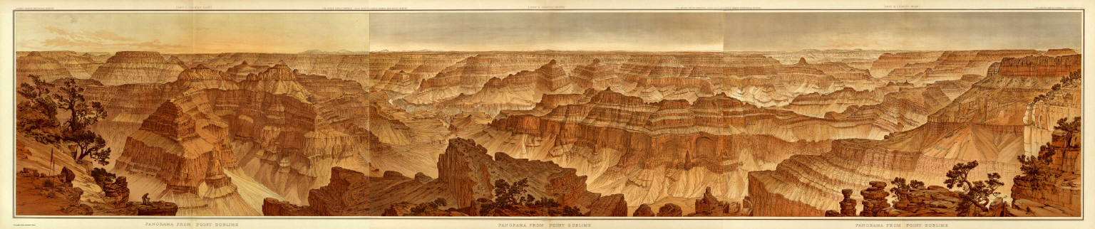
Full Title
Panorama from Point Sublime. [Part I. Looking East.] W(illiam) H. H(olmes). Atlas Sheets XV. Julius Bien & Co. lith. U.S. Geological Survey, Geology of the Grand Canon District.
List No
4713.016
Note
In full color. First of three sheets.
Author
[Dutton, Clarence E. (Clarence Edward), 1841-1912, Holmes, William Henry, 1846-1933]
Full Title
Panorama from Point Sublime. [Part II. Looking South.] W(illiam) H. H(olmes) Atlas Sheets XVI. Julius Bien & Co. lith. U.S. Geological Survey, Geology of the Grand Canon District.
List No
4713.017
Note
In full color. Second of three sheets.
Author
[Dutton, Clarence E. (Clarence Edward), 1841-1912, Holmes, William Henry, 1846-1933]
Full Title
Panorama from Point Sublime. [Part III. Looking West.] W(illiam) H. H(olmes). Atlas Sheets XVII. Julius Bien & Co. lith. U.S. Geological Survey, Geology of the Grand Canon District.
List No
4713.018
Note
In full color. Third of three sheets.
Author
[Dutton, Clarence E. (Clarence Edward), 1841-1912, Holmes, William Henry, 1846-1933]
Full Title
(Composite) Panorama From Point Sublime. [Parts I-III.] W.H. Holmes. Atlas Sheets XV-XVII. Julius Bien & Co. lith. U.S. Geological Survey, Geology of the Grand Canon District.
List No
4713.019
Note
In full color. Composite of all sections using Atlas Sheets 15-17.
Author
[Dutton, Clarence E. (Clarence Edward), 1841-1912, Moran, Thomas, 1837-1926]
Full Title
The Transept, Kaibab Division, Grand Canon. An amphitheater of the Second Order. (By Thomas Moran). Atlas Sheet XVIII. Julius Bien & Co. lith. U.S. Geological Survey, Geology of the Grand Canon District.
List No
4713.020
Note
In full color.
Author
[Dutton, Clarence E. (Clarence Edward), 1841-1912, Holmes, William Henry, 1846-1933]
Full Title
Views of the Marble Canon Platform from the eastern brink of the Kabib. W(illiam) H. H(olmes). Atlas Sheet XIX. Julius Bien & Co. lith. U.S. Geological Survey, Geology of the Grand Canon District.
List No
4713.021
Note
In full color. The views are continuous. The upper view looks east and the lower, south.
Author
Dutton, Clarence E. (Clarence Edward), 1841-1912
Full Title
Geologic Map Showing The South-Western Portion Of The Mesozoic Terraces And The Vicinity Of The Hurricane Fault. Atlas Sheet XX. Geology by C.E. Dutton. Julius Bien & Co. lith. U.S. Geological Survey, Geology of the Grand Canon District.
List No
4713.022
Note
In full color. First of four sheets.
Author
Dutton, Clarence E. (Clarence Edward), 1841-1912
Full Title
Geologic Map Of The Mesozoic Terraces Of The Grand Canon District And The Southern Portions Of The High Plateaus. Atlas Sheet XXI. Geology by C.E. Dutton. Julius Bien & Co. lith. U.S. Geological Survey, Geology of the Grand Canon District.
List No
4713.023
Note
In full color. Second of four sheets.
Author
Dutton, Clarence E. (Clarence Edward), 1841-1912
Full Title
Geologic Map Showing The Kanab, Paria And Marble Canon Platforms. Atlas Sheet XXII. Geology by C.E. Dutton. Julius Bien & Co. lith. U.S. Geological Survey, Geology of the Grand Canon District.
List No
4713.024
Note
In full color. Third of four sheets.
Author
Dutton, Clarence E. (Clarence Edward), 1841-1912
Full Title
Geologic Map Of The Colorado Plateau And San Francisco Mountains. Atlas Sheet XXIII. Geology by C.E. Dutton. Julius Bien & Co. lith. U.S. Geological Survey, Geology of the Grand Canon District.
List No
4713.025
Note
In full color. Fourth of four sheets. Map notes that the area "has been well surveyed topographically but has been reconnoitred only by the Geologists. The colors therefore are to be regarded only as an approximation to the distribution of the strata."
Author
Dutton, Clarence E. (Clarence Edward), 1841-1912
Full Title
(Composite) Geologic Map Sheets XX-XXIII. Geology by C.E. Dutton. Julius Bien & Co. lith. U.S. Geological Survey, Geology of the Grand Canon District.
List No
4713.026
Note
Composite map consists of four sheets although it was originally intended to have six. A note in the index states that "although much material has been obtained for their construction, much more is still required. No attempt to supply the defect has, therefore, been made in the present work." In full color.
Author
[Walling, Henry Francis, 1825-1888, Lloyd, H.H.]
Full Title
Geological map of Ohio. By J. S. Newberry, L. L. D.Based upon that of Col. Charles Whittelsey. Published for Henry S. Stebbins By H.H. Lloyd & Co. New York. (to accompany) Atlas Of The State Of Ohio 1868.
List No
4726.008
Note
Hand colored map. Shows geologic formations, types of rock, towns, rivers, canals and railroads. Includes "Section through northern Ohio," "Section from Cincinnati to Marietta," and explanation of colors.
Author
Gray, Ormando Willis
Full Title
Gray's Atlas Map of the United States Showing the Principal Geological Formations by Cha's. H. Hitchcock, Ph.D.,Professor of Geology in Dartmouth College.
List No
4740.011
Note
Prime meridians Washington D.C. and Greenwich. Relief shown by hachures.
Author
Dussieux, L.
Full Title
64. Croquis d'une Carte Geologique de la France.
List No
4759.064
Note
Full color.
Author
Rand McNally and Company
Full Title
(Covers to) Rand, McNally & Co.'s new geological map of Colorado. Copyright, 1879, by Rand, McNally & Co.
List No
4788A
Note
This is a very unusual map for Rand McNally to issue - geological maps were not common in their catalog and this may be the only one they published. It was probably the interest in mining that motivated publication and the inclusion of "Mineralogical References" in the map key. The main source for the geological formations was Hayden's General Geological Map of Colorado that appeared in his 1877 Atlas of Colorado. But Rand McNally's map has much more detail on towns and railroads than Hayden and is a much superior map in that respect. Ellis 82 is the 1880 edition, which was also issued without geological coloring as "Rand McNally & Co.'s New Sectional Map of Colorado." This map is in printed full color, folded into dark blue cloth covers 16.5x10 titled "Rand, McNally & Co's geological and mineralogical maps Of Colorado" in gold.
Author
Rand McNally and Company
Full Title
Rand, McNally & Co.'s new geological map of Colorado. Copyright, 1879, by Rand, McNally & Co.
List No
4788.001
Note
This is a very unusual map for Rand McNally to issue - geological maps were not common in their catalog and this may be the only one they published. It was probably the interest in mining that motivated publication and the inclusion of "Mineralogical References" in the map key. The main source for the geological formations was Hayden's General Geological Map of Colorado that appeared in his 1877 Atlas of Colorado. But Rand McNally's map has much more detail on towns and railroads than Hayden and is a much superior map in that respect. Ellis 82 is the 1880 edition, which was also issued without geological coloring as "Rand McNally & Co.'s New Sectional Map of Colorado." This map is in printed full color, folded into dark blue cloth covers 16.5x10 titled "Rand, McNally & Co's geological and mineralogical maps Of Colorado" in gold.
Author
[Dechen, H. von (Heinrich), 1800-1889, Hughes, William, 1817-1876, Meyer, Joseph, 1796-1856]
Full Title
Geognostische Karte von Central- und West-Europa einschlieslich der Britischen Inseln, Frankreich, Deutschland und der Nachbarlander. Mit Zugrundlage der Karte von Dr. H. von Dechen, Professor der Berliner Universitat, und der Werke der eminentesten europaischen Geologen, entworfen von W. Hughes, F.R.G.S. mit verbesserungen u. Berichtigungen von J. Meyer. 1844. Gez. v. Jos. Graessl. Stich, Druck und Verlag des Bibliographischen Instituts zu Hildburghausen, (1860)
List No
4807.011
Note
Engraved map on 2 sheets. Geologic units hand col. Relief shown by spot heights. Inset map: Forsetzung von Schottland. Some place names and geologic units also in English. Contents: I. Westl. Haelfte -- II. Oestl. Haelfte. Titles in margin: Geognostische Karte v. Mittel-Europa. "Meyer's Handatlas No. 29 ... 30." David Rumsey Collection copy mounted as 1 sheet.
Author
Johnson, A.J.
Full Title
Johnson's World, Showing the Distribution of the Characteristic Forest Trees, Principal Useful Plants and Minerals. By Prof. A. Guyot. Published by A. J. Johnson, New York. 13. Entered according to the Act of Congress, in the year 1870, by A.J. Johnson in the Clerk's Office of the District Court of the United States for the Southern District of New York.
List No
4828.018
Note
Engraved color map, and two insets of mineral distributions.
Author
Johnson, Alvin Jewett, 1827-1884.
Full Title
Johnson's physical map, showing the principal mountains, plateaus & plains of the world. No. I. By Prof. A. Guyot. Published by A.J. Johnson & Son N.Y. (inset profiles) comparative altitude of principal mountains and tablelands of the World. Johnson's world, showing the lines of equal magnetic declination. Epoch 1858. No. II. Johnson's world, showing the course of the tidal-wave in the three great oceans, and distribution of volcanoes. No. III. Johnson's world, showing the distribution of the principal races of man. By Prof. A. Guyot. Entered ... 1870, by A.J. Johnson ... New York. (to accompany) Johnson's New Illustrated Family Atlas Of The World ... MDCCCLXXX (1880).
List No
4830.057
Note
4 physical maps of the world on 1 sheet, 64x44. No. I: 31x42, showing lowlands, highlands and highest lands. Relief shown by hachures. Includes legend and inset profiles. Accompanied by three maps No. II-IV:41.5x28.5, showing world's races, ocean current and volcanoes, and magnetic declination.
Author
[Hinton, Isaac Taylor, 1799-1847, Simpkin & Marshall]
Full Title
A geological map of the United States. Engraved & printed by Fenner Sears & Co. London: Published March 15, 1832 by I.T. Hinton & Simpkin & Marshall.
List No
4966.002
Note
Hand col. engraved map. Relief shown by hachures. Shows 9 geologic units. Inset: Continuation of the western territory on a reduced scale. Prime meridians: Washington and Greenwich. "91."
Author
[Hinton, Isaac Taylor, 1799-1847, Simpkin & Marshall]
Full Title
Geological sections of the United States. Engraved & printed by Fenner Sears & Co. (London: Published March 15, 1832 by I.T. Hinton & Simpkin & Marshall).
List No
4966.004
Note
Two hand col. sections. Vertical scale varies. Contents: Northern section, at nearly 41 (degrees) north latitude -- Southern section, at nearly 35 (degrees) north latitude. Prime meridian: Washington. "90." Issued to accompany: A geological map of the United States. 1832.
Author
[Franks, Theo., Brady's Bend Iron Co.]
Full Title
Topographical & Geological Map Of The Property Belonging To The Brady's Bend Iron Co. Located In Armstrong County Pa. by Theo. Franks Civil Engineer. From Plan drawn by R. Jennings, Brady's Bend. Wm Schuchman, lith. 3d St, Pittsburgh, Pa. (inset) Geological Section From Notes By Prof. Shepherd.
List No
5002.000
Note
This remarkable large map shows in great detail the works of the Brandy's Bend Iron Co. on the Allegheny River northeast of Pittsburgh. The scale is large and the map is subtly colored. All the buildings, tracks, roads and Collieries are delineated. There is a "Geological Section from Notes by Prof. Shepherd" showing the land on which the Iron Company is built. Two vignettes show the imposing buildings. Why this map was made is not clear, certainly not for general consumption, but perhaps for investors or others specifically interested in the Companies facilities. The date is estimated. Scale 300 feet to an inch.
Author
[Best, Edward, Edward Stanford Ltd., Stanford, Edward]
Full Title
Geological map of the British Isles by Edward Best. Edward Best, Geological Survey. London atlas series. Stanford's Geographical Establishment. London : Edward Stanford, 12, 13 & 14 Long Acre, W.C. (1901)
List No
5075.010
Note
Full color. Shows 27 geologic units. Includes inset of the Shetland and Orkney islands. "VIII.87, XI.93."
Author
[Whitney, J.D., Foster, J.W.]
Full Title
Carte geologique du Lac Superieur. Etat De Michigan. Drefsee par M.rs J.W. Fosters et J.D. Whitney geologues des Etats Unia. Annales des Mines, 5e Serie, Tome VII, pages 173 et suivantes. Lemaitre sc. Voyage au Lac Superieur. Geologie. Pl. VI.
List No
5290.000
Note
This is a French issue of the Foster/Whitney geological maps of Lake Superior from the 1849 report (see our #1059). Hand-painted color shows geologic formation in the Lake Superior vicinity.
Author
[Bristow, Henry W., Letts, Son & Co.]
Full Title
Geological map of England & Wales, with leading railways by Henry W. Bristow, F.R.S., F.G.S., Director of the Geological Survey of England and Wales. Letts's popular atlas. Letts, Son & Co. Limited, London. (1883)
List No
5371.007
Note
Colored map. Includes descriptive notes and explanation.
Author
Letts, Son & Co.
Full Title
Geological map of the environs of London. Letts's popular atlas. Letts, Son & Co. Limited, London. (1883)
List No
5371.015
Note
Colored map. Relief shown by hachures. Shows railroads, radial distances from Charing Cross, explanation, etc. "This map can be purchased separately, mounted on a board and varnished for 2/6, or backed with the "Orographical Map" for 3/6.
Author
Letts, Son & Co.
Full Title
Geological map of the environs of Dublin. Letts's popular atlas. Letts, Son & Co. Limited, London. (1883)
List No
5371.024
Note
Colored map. Relief shown by hachures. Shows 14 geologic units, railroads, settlements, rivers, etc.
Author
Letts, Son & Co.
Full Title
Geological map of the environs of Edinburgh. Letts's popular atlas. Letts, Son & Co. Limited, London. (1883)
List No
5371.030
Note
Colored map. Relief shown by hachures and spot heights. Shows also railroads, roads, settlements, rivers, etc.
Author
Brown, R. T.
Full Title
New topographical atlas and gazetteer of Indiana. Lawrence, Jackson, Jennings, Washington, Scott, Jefferson, Harrison, Switzerland, Floyd, Clarke, Ohio counties. (with) Geological map of Indiana, by Prof. R.T. Brown. (Indianapolis: Higgins & Ryan, 1870)
List No
5478.002
Note
Hand colored by township. Shows settlements, roads, railroads, canals, section lines, congressional districts, etc. Includes explanation to geologic map.
Author
Egloffstein, Baron F.W. von
Full Title
(Covers to) Contributions to the Geology and the Physical Geography of Mexico, including a Geological and Topographical Map, with profiles, Of some of the principal Mining Districts; together with a graphic description of an ascent of The Volcano Popocatepetl. Edited by Baron F.W. von Egloffstein. New York: D. Appleton & Company, 443 & 445 Broadway. 1864. (on verso) Entered ... 1864, by F.W. von Egloffstein ... New York.
List No
5521.001
Note
Includes two beautifully engraved maps of the region including Mexico City, showing the topography of the area and then with a geologic overlay. Bound with cloth covers and the title embossed on the cover.
Author
Egloffstein, Baron F.W. von
Full Title
(Title Page to) Contributions to the Geology and the Physical Geography of Mexico, including a Geological and Topographical Map, with profiles, Of some of the principal Mining Districts; together with a graphic description of an ascent of The Volcano Popocatepetl. Edited by Baron F.W. von Egloffstein. New York: D. Appleton & Company, 443 & 445 Broadway. 1864. (on verso) Entered ... 1864, by F.W. von Egloffstein ... New York.
List No
5521.002
Note
Includes two beautifully engraved maps of the region including Mexico City, showing the topography of the area and then with a geologic overlay. Bound with cloth covers and the title embossed on the cover.
Author
Egloffstein, Baron F.W. von
Full Title
(Text Page to) Introduction. (to accompany) Contributions to the Geology and the Physical Geography of Mexico, including a Geological and Topographical Map ... 1864. (on opposite page) Entered ... 1864, by F.W. von Egloffstein ... New York.
List No
5521.003
Note
Introduction and copyright information: Includes two beautifully engraved maps of the region including Mexico City, showing the topography of the area and then with a geologic overlay. Bound with cloth covers and the title embossed on the cover.
Author
Egloffstein, Baron F.W. von
Full Title
(Text Page to) Introduction. (to accompany) Contributions to the Geology and the Physical Geography of Mexico, including a Geological and Topographical Map ... 1864. (on opposite page) Entered ... 1864, by F.W. von Egloffstein ... New York.
List No
5521.004
Note
Introduction: Includes two beautifully engraved maps of the region including Mexico City, showing the topography of the area and then with a geologic overlay. Bound with cloth covers and the title embossed on the cover.
Author
Jouvet et Cie.
Full Title
Carte Geologique de la Region Francaise. Atlas St. Cyr. G. Hue. Furne, Jouvet et Cie. Editeurs. Imp. Lemercier et Cie. Paris. (1882)
List No
5785.008
Note
Full color of geologic formations. Relief shown in hachures. Inset of Corsica.
Author
[Bayer, Herbert, Container Corporation of America]
Full Title
(Text Page) Astronomy. The Moon. Our Planet.
List No
5842.009
Note
Includes phases of the moon, tides, lunar eclipse, and motion of earth's axis. Earth layers, earthquakes, and continental drift (tectonics) hypothesis presented.
Author
[Bayer, Herbert, Container Corporation of America]
Full Title
(Text Page) Geology.
List No
5842.010
Note
Presents geomorphic processes including erosion, deposition, aeolian effects, meandering, wave-cutting, waves, folding, faulting, glaciation, groundwater, springs, artesian wells, and weathering.
Author
[Bayer, Herbert, Container Corporation of America]
Full Title
(Text Page) Geology.
List No
5842.011
Note
Includes metamorphic rocks, vulcanism, igneous rocks, paleontology, fossils, North American geologic history, and fossil timeline.
Author
[Bayer, Herbert, Container Corporation of America]
Full Title
U.S.A. Physiographic.
List No
5842.037
Note
Three cross-sections.
Author
[Hayden, F.V., Holmes, William Henry, 1846-1933, U.S. Geological and Geographical Survey of the Territories]
Full Title
Panoramic Views (Wyoming). W.H. Holmes. U.S. Geological and Geographical Survey of the Territories. F.V. Hayden in Charge. J. Bien, Photo. Lith.
List No
5939.000
Note
3 Views on one sheet, without color. (1) Glacial lake and moraines on new fork of Green River, Wind River Mountains. (2) The Glaciers of Frémont's Peak, Wind River Mountains, Wyoming. (3) The Teton Range from Upper Grosventre Butte looking west, with the valley of Snake River in the foreground. To accompany the Survey's 12th annual report (1878).
Author
[Hayden, F.V., U.S. Geological and Geographical Survey of the Territories]
Full Title
Part of Central Wyoming, U.S. Geological and Geographical Survey of the Territories ; F.V. Hayden, U.S. Geologist in Charge. F.M. Endlich , Geological Assistant. George B. Chittenden, C. F. Topographical Assistant. Surveyed in 1877.
List No
5942.000
Note
Full color geologic map. Shows geologic formations and sedimentary chart. Relief by shown by contours and spot heights. " Contour interval 200 feet". "57" on the Lower right margin. To accompany the Survey's 12th annual report (1878).
Author
[U.S. Geological and Geographical Survey of the Territories, Hayden,Ferdinand Vandeveer]
Full Title
Parts of Western Wyoming and Southeastern Idaho. U.S. Geological and Geographical Survey of the Territories ; F.V. Hayden, U.S. Geologist in Charge. O. St. John, Geological Assistant. Gustavus R Bechler; Fred A Clark; Topographical Assistants. Surveyed in 1877 & 78.
List No
5944.000
Note
Full color geologic map. Shows geologic formations and sedimentary chart. Relief by shown by contours and spot heights. " Contour interval 200 feet". "45" on the Lower right margin. To accompany the Survey's 12th annual report (1878).
Author
[U.S. Geological and Geographical Survey of the Territories, Hayden,Ferdinand Vandeveer]
Full Title
Preliminary Geological Map of the Yellowstone National Park. Department of the Interior, U.S. Geological and Geographical Survey of the Territories ; F.V. Hayden, U.S. Geologist in Charge ; W.H. Holmes, Geological Assistant ; Primary Triangulation by A.D. Wilson ; Secondary Triangulation and Topography by Henry Gannett. Surveyed in 1878. Julius Bien, Lith.
List No
5947.000
Note
Full color map. Relief shown by contours and spot heights. Depths shown by soundings. Includes sedimentary charts, and notes. No. 6 on verso. To accompany the Survey's 12th annual report (1878).
Author
[U.S. Geological and Geographical Survey of the Territories, Hayden,Ferdinand Vandeveer]
Full Title
Geological Map of Portions of Wyoming, Idaho and Utah. Department of the Interior, U.S. Geological and Geographical Survey of the Territories ; F.V. Hayden, U.S. Geologist in Charge ; Geology by A C Peale; Orestes St John; F.M. Endlich. Julius Bien, Lith., N.Y.
List No
5948.000
Note
Full color map. Relief shown by hachures and spot heights. Includes sedimentary charts. To accompany the Survey's 12th annual report (1878).
Author
[Kartographia Winterthur, Conférence Suisse des Directeurs Cantonaux de l'instruction Publique]
Full Title
Carte Geologique des Alpes. Kartographia Winterthur S.A. Conference des Chefs des Depart. Cant. de l'Instruction Publique. Atlas Scolaire 2e. Edition.
List No
5967.012
Note
Full color map. Relief shown by shadings.
Author
Lobeck, A. K.
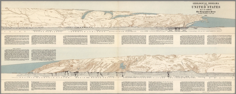
Full Title
Geological Diorama of the United States. By A.K. Lobeck, The Geographical Press, Columbia University, New York, 1949.
List No
6095.000
Author
California Division of Mines and Geology
Full Title
Geologic Map of California, Alturas Sheet.
List No
6347.009
Note
Full color.
Author
California Division of Mines and Geology
Full Title
Geologic Map of California, Bakersfield Sheet.
List No
6347.013
Note
Full color.
Author
California Division of Mines and Geology
Full Title
Geologic Map of California, Chico Sheet.
List No
6347.017
Note
Full color.
Author
California Division of Mines and Geology
Full Title
Geologic Map of California, Death Valley Sheet.
List No
6347.021
Note
Full color. Olaf P. Jenkins Edition.
Author
California Division of Mines and Geology
Full Title
Geologic Map of California, Fresno Sheet.
List No
6347.025
Note
Full color. Olaf P. Jenkins Edition.
Author
California Division of Mines and Geology
Full Title
Geologic Map of California, Kingman Sheet.
List No
6347.029
Note
Full color. Olaf P. Jenkins Edition.
Author
California Division of Mines and Geology
Full Title
Geologic Map of California, Long Beach Sheet.
List No
6347.033
Note
Full color. Olaf P. Jenkins Edition.
Author
California Division of Mines and Geology
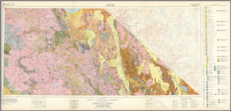
Full Title
Geologic Map of California, Mariposa Sheet.
List No
6347.041
Note
Full color. Olaf P. Jenkins Edition.
Author
California Division of Mines and Geology
Full Title
Geologic Map of California, Needles Sheet.
List No
6347.045
Note
Full color. Olaf P. Jenkins Edition.
Author
California Division of Mines and Geology
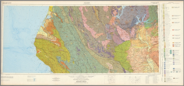
Full Title
Geologic Map of California, Redding Sheet.
List No
6347.049
Note
Full color. Olaf P. Jenkins Edition.
Author
California Division of Mines and Geology
Full Title
Geologic Map of California, Sacramento Sheet.
List No
6347.053
Note
Full color. Olaf P. Jenkins Edition.
Author
California Division of Mines and Geology
Full Title
Geologic Map of California, Salton Sea Sheet.
List No
6347.057
Note
Full color. Olaf P. Jenkins Edition.
Author
California Division of Mines and Geology
Full Title
Geologic Map of California, San Bernadino Sheet.
List No
6347.061
Note
Full color. Olaf P. Jenkins Edition.
Author
California Division of Mines and Geology
Full Title
Geologic Map of California, San Diego - El Centro Sheet.
List No
6347.065
Note
Full color. Olaf P. Jenkins Edition.
Author
California Division of Mines and Geology
Full Title
Geologic Map of California, San Francisco Sheet.
List No
6347.069
Note
Full color. Olaf P. Jenkins Edition.
Author
California Division of Mines and Geology
Full Title
Geologic Map of California, San Jose Sheet.
List No
6347.073
Note
Full color. Olaf P. Jenkins Edition.
Author
California Division of Mines and Geology
Full Title
Geologic Map of California, San Luis Obisbo Sheet.
List No
6347.077
Note
Full color. Olaf P. Jenkins Edition.
Author
California Division of Mines and Geology
Full Title
Geologic Map of California, Santa Ana Sheet.
List No
6347.081
Note
Full color. Olaf P. Jenkins Edition.
Author
California Division of Mines and Geology
Full Title
Geologic Map of California, Santa Cruz Sheet.
List No
6347.085
Note
Full color. Olaf P. Jenkins Edition.
Author
California Division of Mines and Geology
Full Title
Geologic Map of California, Santa Maria Sheet.
List No
6347.089
Note
Full color. Olaf P. Jenkins Edition.
Author
California Division of Mines and Geology
Full Title
Geologic Map of California, Santa Rosa Sheet.
List No
6347.093
Note
Full color. Olaf P. Jenkins Edition.
Author
California Division of Mines and Geology
Full Title
Geologic Map of California, Trona Sheet.
List No
6347.097
Note
Full color. Olaf P. Jenkins Edition.
Author
California Division of Mines and Geology
Full Title
Geologic Map of California, Ukiah Sheet.
List No
6347.101
Note
Full color. Olaf P. Jenkins Edition.
Author
California Division of Mines and Geology
Full Title
Geologic Map of California, Walker Lake Sheet.
List No
6347.105
Note
Full color. Olaf P. Jenkins Edition.
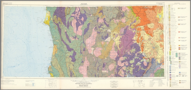
Author
California Division of Mines and Geology
Full Title
Geologic Map of California, Weed Sheet.
List No
6347.109
Note
Full color. Olaf P. Jenkins Edition.
Author
California Division of Mines and Geology
Full Title
Geologic Map of California, Westwood Sheet.
List No
6347.113
Note
Full color. Olaf P. Jenkins Edition.
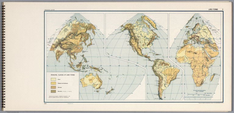
Author
[United States Army Service Forces, American Geographical Society]
Full Title
Land Forms 2.
List No
6351.016
Note
1058-G.
Author
[U.S. Geological Survey, Schmidt, Robert G., Shaw, Herbert R.]
Full Title
Magma and Lava.
List No
6352.001
Author
[U.S. Geological Survey, Schmidt, Robert G., Shaw, Herbert R.]
Full Title
Magmatic Differentiation.
List No
6352.002
Author
[U.S. Geological Survey, Schmidt, Robert G.]
Full Title
Distribution and Environment of Volcanoes.
List No
6352.003
Author
[U.S. Geological Survey, Schmidt, Robert G.]
Full Title
Shield Volcanoes.
List No
6352.004
Author
[U.S. Geological Survey, Schmidt, Robert G.]
Full Title
Cinder Cones.
List No
6352.005
Author
[U.S. Geological Survey, Schmidt, Robert G.]
Full Title
Composite Volcanoes.
List No
6352.006
Author
[U.S. Geological Survey, Schmidt, Robert G.]
Full Title
Volcanic Domes.
List No
6352.007
Author
[U.S. Geological Survey, Schmidt, Robert G.]
Full Title
Evolution and Erosion of a Composite Volcano.
List No
6352.008
Author
[U.S. Geological Survey, Schmidt, Robert G., Bailey, Roy A.]
Full Title
Calderas.
List No
6352.009
Author
[U.S. Geological Survey, Schmidt, Robert G., Smith, Robert L.]
Full Title
Ash Flows.
List No
6352.010
Author
[U.S. Geological Survey, Fiske, Richard S.]
Full Title
Flood Basalts of the Columbia River Plateau.
List No
6352.011
Author
[U.S. Geological Survey, Fiske, Richard S.]
Full Title
Submarine Volcanoes.
List No
6352.012
Author
[U.S. Geological Survey, Schmidt, Robert G., Hearn Jr., B. Carter]
Full Title
Maars, Diatremes and Cryptovolcanic Structures.
List No
6352.013
Author
[U.S. Geological Survey, Schmidt, Robert G., Hearn Jr., B. Carter]
Full Title
Development of a Diatreme.
List No
6352.014
Author
[U.S. Geological Survey, White, Donald E.]
Full Title
Geyers, Solfataras and Hot Springs.
List No
6352.015
Author
[U.S. Geological Survey, Schmidt, Robert G.]
Full Title
Types of Volcanic Eruptions.
List No
6352.016
Author
[U.S. Geological Survey, Schmidt, Robert G.]
Full Title
Hawaiian Volcanic Observatory - Studies of Volcanic Products and Processes.
List No
6352.017
Author
[U.S. Geological Survey, Schmidt, Robert G.]
Full Title
Hawaiian Volcanic Observatory.
List No
6352.018
Author
[U.S. Geological Survey, Schmidt, Robert G., Eaton, Jerry P.]
Full Title
Kilauea.
List No
6352.019
Author
[U.S. Geological Survey, Schmidt, Robert G.]
Full Title
Volcanism and Human Affairs.
List No
6352.020
Author
[U.S. Geological Survey, Alpha, Tau Rho, Detterman, Janis S., Morley, James M.]
Full Title
(Index Map) Location of Oblique Maps in Alaska and the North Pacific.
List No
6353.009
Author
[U.S. Geological Survey, Alpha, Tau Rho, Gerin, Marybeth, Joyce, James M.]
Full Title
Oblique Map of the Gulf of Alaska.
List No
6353.010
Author
[U.S. Geological Survey, Alpha, Tau Rho]
Full Title
The Aleutian-Kamchatka Convergence, North Pacific Ocean.
List No
6353.011
Author
[U.S. Geological Survey, Alpha, Tau Rho]
Full Title
Central Aleutian Arc, Alaska.
List No
6353.012
Author
[U.S. Geological Survey, Alpha, Tau Rho, Winegard, Charles I.]
Full Title
Eastern Aleutian Trench and Northern Gulf of Alaska.
List No
6353.013
Author
[U.S. Geological Survey, Alpha, Tau Rho]
Full Title
A Part of the Eastern Aleutian Trench.
List No
6353.014
Author
[U.S. Geological Survey, Alpha, Tau Rho, Scholl, David W., Vallier, T.L.]
Full Title
Amlia Corridor, Alaska.
List No
6353.015
Author
[U.S. Geological Survey, Alpha, Tau Rho, Morley, James M., Eittreim, Stephen]
Full Title
Barrow Canyon, Alaska.
List No
6353.016
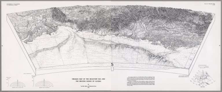
Author
[U.S. Geological Survey, Alpha, Tau Rho, Gerin, Marybeth]
Full Title
Oblique Map of the Beaufort Sea and the Brooks Range of Alaska.
List No
6353.017
Author
[U.S. Geological Survey, Alpha, Tau Rho]
Full Title
Bering Canyon, Aleutian Islands, Alaska.
List No
6353.018
Author
[U.S. Geological Survey, Alpha, Tau Rho]
Full Title
Oblique Map of the Bering Sea.
List No
6353.019
Author
[U.S. Geological Survey, Alpha, Tau Rho]
Full Title
Northern Bering Sea.
List No
6353.020
Author
[U.S. Geological Survey, Alpha, Tau Rho]
Full Title
Physiography Bering Sea Shelf, Alaska.
List No
6353.021
Author
[U.S. Geological Survey, Alpha, Tau Rho, Scholl, D.W., Buffington, E.C.]
Full Title
Physiography and Cross Sections Bering Sea Shelf, Alaska.
List No
6353.022
Author
[U.S. Geological Survey, Alpha, Tau Rho, Detterman, Janis S., Morley, James M.]
Full Title
Pre-Tertiary Rocks Bering Sea Shelf, Alaska.
List No
6353.023
Author
[U.S. Geological Survey, Alpha, Tau Rho, Scholl, D.W., Marlow, M.S., Cooper, A.K.]
Full Title
Pre-Tertiary Rocks Southern Bering Sea Shelf, Alaska.
List No
6353.024
Author
[U.S. Geological Survey, Alpha, Tau Rho]
Full Title
Buldir Depression, Aleutian Islands, Alaska.
List No
6353.025
Author
[U.S. Geological Survey, Alpha, Tau Rho]
Full Title
Emperor Seamounts, North Pacific Ocean.
List No
6353.026
Author
[U.S. Geological Survey, Alpha, Tau Rho, Vallier, T.L.]
Full Title
Oblique Map of Hess Rise and Vicinity, North-Central Pacific Ocean.
List No
6353.027
Author
[U.S. Geological Survey, Alpha, Tau Rho]
Full Title
Icy Bay, Alaska.
List No
6353.028
Author
[U.S. Geological Survey, Alpha, Tau Rho]
Full Title
Kayak Trough, Gulf of Alaska.
List No
6353.029
Author
[U.S. Geological Survey, Alpha, Tau Rho]
Full Title
Nuka Bay, Alaska.
List No
6353.030
Author
[U.S. Geological Survey, Alpha, Tau Rho]
Full Title
Pamplona Ridge, Gulf of Alaska.
List No
6353.031
Author
[U.S. Geological Survey, Alpha, Tau Rho]
Full Title
Passage Canal, Alaska.
List No
6353.032
Author
[U.S. Geological Survey, Alpha, Tau Rho]
Full Title
Pribilof Canyon, Bering Sea, Alaska.
List No
6353.033
Author
[U.S. Geological Survey, Alpha, Tau Rho]
Full Title
Exploded Diagram Pribilof Canyon, Bering Sea, Alaska.
List No
6353.034
Author
[U.S. Geological Survey, Alpha, Tau Rho]
Full Title
Revised Pribiloff Canyon, Bering Sea, Alaska.
List No
6353.035
Author
[U.S. Geological Survey, Alpha, Tau Rho, Reimnitz, Erk, Rodeick, Craig, Oesterle, Andrew D.]
Full Title
Diving Observation Diagram of Reindeer Island, Alaska.
List No
6353.036
Author
[U.S. Geological Survey, Alpha, Tau Rho]
Full Title
Resurrection Bay, Alaska.
List No
6353.037
Author
[U.S. Geological Survey, Alpha, Tau Rho]
Full Title
Port Valdez, Alaska.
List No
6353.038
Author
[U.S. Geological Survey, Alpha, Tau Rho]
Full Title
Zhemchug Canyon, Bering Sea, Alaska.
List No
6353.039
Author
[U.S. Geological Survey, Alpha, Tau Rho]
Full Title
Exploded Diagram Zhemchug Canyon, Bering Sea, Alaska.
List No
6353.040
Author
[U.S. Geological Survey, Alpha, Tau Rho, Detterman, Janis S., Morley, James M.]
Full Title
(Index Map) Location of Oblique Maps in the Pacific Northwest.
List No
6353.042
Author
[U.S. Geological Survey, Alpha, Tau Rho]
Full Title
Astoria Canyon, Oregon-Washington.
List No
6353.043
Author
[U.S. Geological Survey, Alpha, Tau Rho]
Full Title
Cape Blanco, Oregon.
List No
6353.044
Author
[U.S. Geological Survey, Alpha, Tau Rho]
Full Title
Mount Baker, Washington. Mt. St. Helens, Washington.
List No
6353.045
Author
[U.S. Geological Survey, Alpha, Tau Rho, Moore, James G., Jones, David R.]
Full Title
Sequential Physiographic Diagrams of Mount St. Helens, Washington 1979-80.
List No
6353.046
Author
[U.S. Geological Survey, Alpha, Tau Rho, Morley, James M., Moore, James G., Jones, David R.]
Full Title
Mount Galway, Waterton Lakes National Park, Alberta, Canada. Physiographic Diagrams of Mount St. Helens and Vicinity, Washington, 1980.
List No
6353.047
Author
[U.S. Geological Survey, Alpha, Tau Rho, Morley, James M., Moore, James G., Jones, David R.]
Full Title
Physiographic Diagrams of Mount St. Helens and Vicinity, Washington, 1980 - Continued. Pre-Eruption. Effects of Eruption through June 1980.
List No
6353.048
Author
[U.S. Geological Survey, Alpha, Tau Rho, Morley, James M., Moore, James G., Jones, David R.]
Full Title
A Part of the Physiographic Diagrams of Mount St. Helens and Vicinity, Washington, 1980. Effects of Eruption through June 1980.
List No
6353.049
Author
[U.S. Geological Survey, Alpha, Tau Rho, Moore, James G.]
Full Title
Physiographic Diagrams of the May 18, 1980, Landslide-Eruption of Mount St. Helens, Washington.
List No
6353.050
Author
[U.S. Geological Survey, Alpha, Tau Rho, Morley, James M.]
Full Title
Mt. Wilbur from near Ptarmigan Falls, Glacier National Park, Montana. Comparative Physiographic Diagrams of Mount St. Helens, Washington, and Crater Lake, Oregon.
List No
6353.051
Author
[Alpha, Tau Rho, Morley, James M., U.S. Geological Survey]
Full Title
Comparative Physiographic Diagrams of Mount St. Helens, Washington, and Crater Lake, Oregon - Continued.
List No
6353.052
Author
[U.S. Geological Survey, Alpha, Tau Rho, Morley, James M., Moore, James G., Jones, David R.]
Full Title
Physiographic Diagrams of Mount St. Helens, Washington, Showing Changes in its Summit Crater, Summer 1980.
List No
6353.053
Author
[U.S. Geological Survey, Alpha, Tau Rho, Morley, James M., Moore, James G., Jones, David R.]
Full Title
Physiographic Diagrams of Mount St. Helens, Washington, Showing Changes in its Summit Crater, Summer 1980 - Continued.
List No
6353.054
Author
[U.S. Geological Survey, Alpha, Tau Rho, Morley, James M., Moore, James G., Jones, David R.]
Full Title
Physiographic Diagrams of Mount St. Helens, Washington, Showing Changes in its Summit Crater, Summer 1980 - Continued. June 5, 1980. July 1, 1980. August 1, 1980. August 10, 1980.
List No
6353.055
Author
[U.S. Geological Survey, Alpha, Tau Rho, Morley, James M., Myers, Bobbie, Leighley, Terry]
Full Title
Physiographic Diagrams of Mount St. Helens, Washington, Showing Changes in its Summit Crater, Summer 1981.
List No
6353.056
Author
[U.S. Geological Survey, Alpha, Tau Rho, Morley, James M., Myers, Bobbie, Leighley, Terry]
Full Title
Physiographic Diagrams of Mount St. Helens, Washington, Showing Changes in its Summit Crater, Summer 1981 - Continued. July 1, 1981.
List No
6353.057
Author
[U.S. Geological Survey, Alpha, Tau Rho, Morley, James M., Myers, Bobbie, Leighley, Terry]
Full Title
Physiographic Diagrams of Mount St. Helens, Washington, Showing Changes in its Summit Crater, Summer 1981 - Continued. January 13, February 10, April 13, July 1, October 8, December 20, 1981.
List No
6353.058
Author
[U.S. Geological Survey, Alpha, Tau Rho]
Full Title
Physiographic Diagrams of Mount St. Helens, Washington, Showing Changes in its Summit Crater, Summer 1982. March 25, April 9, 1982.
List No
6353.059
Author
[U.S. Geological Survey, Alpha, Tau Rho]
Full Title
Physiographic Diagrams of Mount St. Helens, Washington, Showing Changes in its Summit Crater, Summer 1982. May 21, July 1, August 24, 1982.
List No
6353.060
Author
[U.S. Geological Survey, Alpha, Tau Rho]
Full Title
Physiographic Diagrams of Mount St. Helens, Washington, Showing Changes in its Summit Crater, Summer 1982. July 1, 1982.
List No
6353.061
Author
[U.S. Geological Survey, Alpha, Tau Rho]
Full Title
Newport, Oregon.
List No
6353.062
Author
[U.S. Geological Survey, Alpha, Tau Rho, Austin, William A.]
Full Title
Physiographic Diagram of the Seven Devils Mountains and Hells Canyon, Idaho and Oregon.
List No
6353.063
Note
Hells Canyon Dam is now (2012) Brownlee Dam.
Author
[U.S. Geological Survey, Alpha, Tau Rho]
Full Title
Strait of Juan de Fuca and Olympic Mountains.
List No
6353.064
Author
[U.S. Geological Survey, Alpha, Tau Rho, Hunter, Ralph E., Richmond, Bruce M.]
Full Title
Landforms of the Umpqua South Area, the Oregon Dunes National Recreation Area, Oregon.
List No
6353.065
Author
[U.S. Geological Survey, Hunter, Ralph E., Richmond, Bruce M., Alpha, Tau Rho]
Full Title
Landforms of the Umpqua South Area, the Oregon Dunes National Recreation Area, Oregon - Continued.
List No
6353.066
Author
[U.S. Geological Survey, Alpha, Tau Rho]
Full Title
Oblique Map of Willapa Bay, Washington.
List No
6353.067
Author
[U.S. Geological Survey, Alpha, Tau Rho, Detterman, Janis S., Morley, James M.]
Full Title
(Index Map) Location of Oblique Maps in California.
List No
6353.069
Author
[U.S. Geological Survey, Alpha, Tau Rho, Morley, James M., Jones, David R., Dingler, John R.]
Full Title
Physiographic Diagram of the Upper Carmel Canyon and Point Lobos, California.
List No
6353.070
Author
[U.S. Geological Survey, Bailey, Roy A., Alpha, Tau Rho, Lojoie, Kenneth R., Clark, Malcolm M.]
Full Title
Physiographic Diagrams of Long Valley, Mono and Inyo Counties, California.
List No
6353.072
Author
[U.S. Geological Survey, Bailey, Roy A., Alpha, Tau Rho, Lojoie, Kenneth R., Clark, Malcolm M.]
Full Title
Physiographic Diagrams of Long Valley, Mono and Inyo Counties, California. - Continued.
List No
6353.073
Author
[U.S. Geological Survey, Alpha, Tau Rho]
Full Title
Monarch Divide, Kings Canyon National Park.
List No
6353.074
Author
[U.S. Geological Survey, Bailey, Roy A., Alpha, Tau Rho, Morley, James M.]
Full Title
Oblique Map of Mono-Inyo Craters, California.
List No
6353.075
Author
[U.S. Geological Survey, Alpha, Tau Rho]
Full Title
Oblique Map of Monterey Bay.
List No
6353.076
Author
[U.S. Geological Survey, Alpha, Tau Rho]
Full Title
Southern Monterey Bay.
List No
6353.077
Note
Geologic interpretation by H. Gary Greene.
Author
[U.S. Geological Survey, Greene, H. Gary]
Full Title
Basement Topography, Monterey Bay Region, California.
List No
6353.078
Author
[U.S. Geological Survey, Alpha, Tau Rho]
Full Title
Monterey Canyon.
List No
6353.079
Author
[U.S. Geological Survey, Alpha, Tau Rho]
Full Title
Diagram Showing Different Stages of Slumping in Monterey Canyon and Relation to Water-Bearing Rocks.
List No
6353.080
Author
[U.S. Geological Survey, Alpha, Tau Rho]
Full Title
Mount Whitney and Vicinity, Tulare and Inyo Counties, California.
List No
6353.081
Author
[U.S. Geological Survey, Alpha, Tau Rho]
Full Title
Eastern Murray Fracture Zone and Transverse Ranges.
List No
6353.082
Author
[U.S. Geological Survey, Alpha, Tau Rho, Gerin, Marybeth]
Full Title
Oblique Map of the Northern California Continental Margin.
List No
6353.083
Author
[U.S. Geological Survey, Alpha, Tau Rho]
Full Title
Pickett Peak Quadrangle, California
List No
6353.084
Author
[U.S. Geological Survey, Alpha, Tau Rho, Detterman, Janis S., Morley, James M.]
Full Title
Compilation of the Oblique Map of Sequoia and Kings Canyon National Parks.
List No
6353.085
Author
[U.S. Geological Survey, Alpha, Tau Rho]
Full Title
Oblique Map of Sequoia and Kings Canyon National Parks, Fresno and Tulare Counties, California.
List No
6353.086
Author
[U.S. Geological Survey, Alpha, Tau Rho]
Full Title
Oblique Map of Southern California, Santa Barbara to San Deigo.
List No
6353.088
Author
[U.S. Geological Survey, Alpha, Tau Rho]
Full Title
Southern California Borderland Oblique Map of the Northwestern Part.
List No
6353.089
Author
[U.S. Geological Survey, Alpha, Tau Rho, Normark, William R., Hess, Gordon R.]
Full Title
Suprafan, Part of the Navy Submarine Fan, California Continental Borderland.
List No
6353.090
Author
[U.S. Geological Survey, Alpha, Tau Rho]
Full Title
Ventura-Oxnard Offshore.
List No
6353.091
Author
[U.S. Geological Survey, Alpha, Tau Rho, Huber, N. King, Wahrhaftig, Clyde]
Full Title
Oblique Map of Yosemite National Park, Central Sierra Nevada, California.
List No
6353.092
Author
[U.S. Geological Survey, Alpha, Tau Rho]
Full Title
Island of Hawaii, Hawaii.
List No
6353.096
Author
[U.S. Geological Survey, Alpha, Tau Rho, Morley, James M., Austin, William A., Gutmacher, Christina E.]
Full Title
Oblique Map of the Loihi Seamount and the Papua Landslide, Hawaii.
List No
6353.097
Author
[U.S. Geological Survey, Alpha, Tau Rho, Greene, H. Gary]
Full Title
Oblique Map of Rabaul, Papua New Guinea.
List No
6353.098
Author
[U.S. Geological Survey, Alpha, Tau Rho, Morley, James M., Austin, William A.]
Full Title
Oblique Map of the Solomon Islands, Southwest Pacific.
List No
6353.099
Author
[U.S. Geological Survey, Alpha, Tau Rho, Morley, James M.]
Full Title
Oblique Map of Southwest Pacific.
List No
6353.100
Author
[U.S. Geological Survey, Alpha, Tau Rho, Morley, James M., Austin, William A.]
Full Title
Oblique Map of the Kingdom of Tonga, Southwest Pacific.
List No
6353.101
Author
[U.S. Geological Survey, Alpha, Tau Rho, Morley, James M., Austin, William A.]
Full Title
Oblique Map of the Republic of Vanuatu, Southwest Pacific.
List No
6353.102
|


![Geologic Map Of The Southern Part Of The Kaibab Plateau. [Part I. North-Western Sheet.]](https://www.davidrumsey.com/rumsey/Size2/D0009/00092151.jpg)
![Geologic Map Of The Southern Part Of The Kaibab Plateau. [Part II. North-Eastern Sheet.]](https://www.davidrumsey.com/rumsey/Size2/D0009/00092152.jpg)
![Geologic Map Of The Southern Part Of The Kaibab Plateau. [Part III. South-Western Sheet.]](https://www.davidrumsey.com/rumsey/Size2/D0009/00092153.jpg)
![Geologic Map Of The Southern Part Of The Kaibab Plateau. [Part IV. South-Eastern Sheet.]](https://www.davidrumsey.com/rumsey/Size2/D0009/00092154.jpg)

![Panorama from Point Sublime. [Part I. Looking East.]](https://www.davidrumsey.com/rumsey/Size2/D0009/00092156.jpg)
![Panorama from Point Sublime. [Part II. Looking South.]](https://www.davidrumsey.com/rumsey/Size2/D0009/00092157.jpg)
![Panorama from Point Sublime. [Part III. Looking West.]](https://www.davidrumsey.com/rumsey/Size2/D0009/00092158.jpg)