|
Author
Hague, Arnold
Full Title
The Shores of Yellowstone Lake. Geology Sheet XXVII. Monograph XXXII. Yellowstone National Park. U.S. Geological Survey. Charles D. Walcott, Director. 1904. Julius Bien & Co. Lith. N.Y. A.H. Thompson, Geographer. Topography by Frank E. Grove, Philip Sawyer under charge of Frank Tweedy. Suveryed in 1889. Arnold Hague, Geologist in charge. Geology by Walter Harvey Weed.
List No
4252.024
Note
Topography shown in 20-foot contours, overlaid in color with 7 classes of rock types. Legend. Note provided on the survey history and on the geomorphic history of Yellowstone Lake.
Paz Soldan, Mariano Felipe, 1821-1886 Temblores en Arequipa; Cortes vertical, ... 1865 4363.068 Related Author
Paz Soldan, Mariano Felipe, 1821-1886
Full Title
Linea que representa los temblores sentidos en Arequipa desde hasta 1845. Corte vertical del camino del Pacifico al Huallaga. Corte vertical del camino de Arica al Cuzco. Plano del Pongo de Manseriche. Vista segun el corte vertical. Paz Soldan. Geografia del Peru. Grabado por Delamare, Paris, Calle St. Andre des Arts 45. Paris, Imp. Janson, r. Antne. Dubois, 6. (Paris: Libreria de Augusto Durand, 1865)
List No
4363.068
Note
Lithographed graph, 2 profiles, map and view on sheet. Map shows relief by hachures and landform drawings. Scale of Pongo de Manseriche map (ca. 1:54,000)
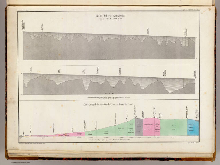
Maw, Henry Lister; Paz Soldan, Mariano F... Lecho, Rio Amazonas; Corte vertical, cam... 1865 4363.069 Related Author
[Maw, Henry Lister, Paz Soldan, Mariano Felipe, 1821-1886]
Full Title
Lecho del Rio Amazonas segun los sondeos de Lister Maw. Corte vertical del camino de Lima al Cerro de Pasco. Paz Soldan. Geografia del Peru. Grabado por Delamare, Calle St. Andre des Arts 45, Paris. Imp. Janson - Paris. (Paris: Libreria de Augusto Durand, 1865)
List No
4363.069
Note
Two river profiles and 1 geologic section. The section is hand col.
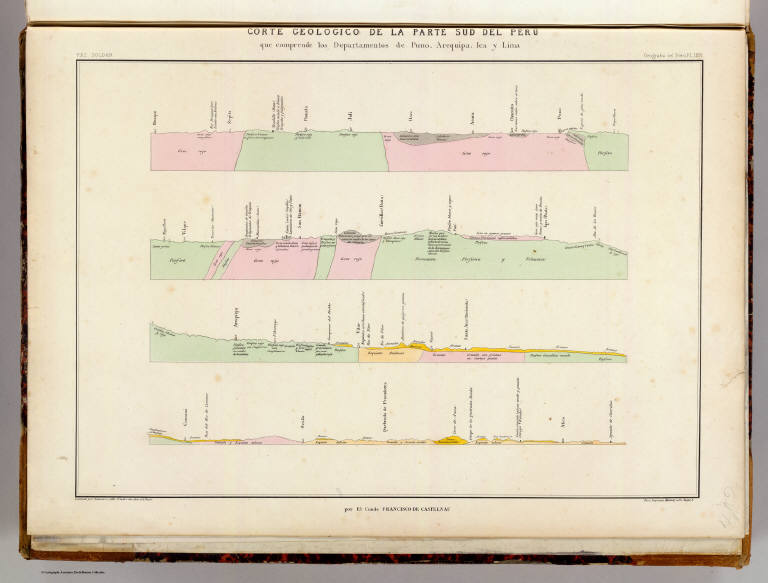
Castelnau, Francis, comte de, 1812-1880;... Corte geologico de la parte sud del Peru... 1865 4363.071 Related Author
[Castelnau, Francis, comte de, 1812-1880, Paz Soldan, Mariano Felipe, 1821-1886]
Full Title
Corte geologico de la parte sud del Peru que comprende los Departamentos de Puno, Arequipa, Ica y Lima por El Conde Francisco de Castelnau. Paz Soldan. Geografia del Peru. Grabado por Delamare, calle St. Andre des Arts, 45, Paris. Paris, Imprenta Monrocq, calle Suger, 3. (Paris: Libreria de Augusto Durand, 1865)
List No
4363.071
Note
Lithographed geological section in 4 segments. Hand col. Misnumbered "LXVI."
Castelnau, Francis, comte de, 1812-1880;... Corte geologico de la parte sud del Peru... 1865 4363.072 Related Author
[Castelnau, Francis, comte de, 1812-1880, Paz Soldan, Mariano Felipe, 1821-1886]
Full Title
Corte geologico de la parte sud del Peru que comprende los Departamentos de Puno, Arequipa, Ica y Lima por El Conde Francisco de Castelnau. Paz Soldan. Geografia del Peru. Grabado por Delamare, Paris, Calle St. Andre des Arts, 45. Paris, Imprenta Monrocq, calle Suger, 3. (Paris: Libreria de Augusto Durand, 1865)
List No
4363.072
Note
Lithographed geological section in 4 segments. Hand col. Misnumbered "LXVII"
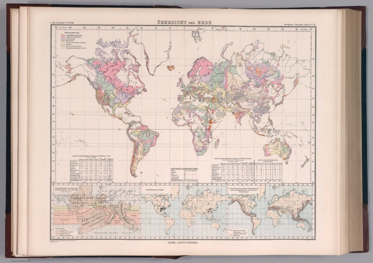
Author
[Berghaus, Heinrich, Berghaus, Hermann, Luddecke, R., Rohrbach, C.]
Full Title
Ubersicht der Erde. Bearbeitet v. Dr. R. Luddecke & Dr. C. Rohrbach. Ausgabe 1892. Gotha: Justus Perthes. (On upper margin) I. Abt. Geologie No. VII/VIII. Berghaus' physikal atlas No. 7/8. (to Accompany) Berghaus' Physikalischer Atlas. (Begrundet 1836 durch Heinrich Berghaus) ... Gotha: Justus Perthes. 1892. (insets) Wahrscheinliche Ausdehnung des Festlandes zur Jurazeit (nach Neumayr. (with) Verbreitung der Kohle. (with) Verbreitung der jungen Kettengebirge und des pazifischen u. atlantischen Kustentypus.
List No
4391.018
Note
Color lithograph map of the world with 3 insets. Includes statistical tables and colors explanation.
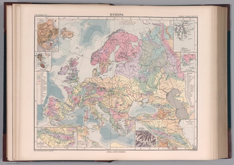
Author
[Berghaus, Heinrich, Berghaus, Hermann, Luddecke, R., Rohrbach, C.]
Full Title
Europa. Entw. v. Herm. Berghaus 1889, Ausg. 1889. Gest. v. A. Herrmann. Gotha: Justus Perthes. (On upper margin) I. Abt. Geologie No. IX. Berghaus' physikal atlas No. 9. (to Accompany) Berghaus' Physikalischer Atlas. (Begrundet 1836 durch Heinrich Berghaus) ... Gotha: Justus Perthes. 1892. (7 insets).
List No
4391.019
Note
Color lithograph map with 7 insets: Laki (Island) -- Vulcano -- Die Pyrenaeen -- Spitzbergen -- Schonen -- Der Kaukasus -- Gletscher des Adai-Choch. Showing major cities, towns, rivers and river basins. Principal geological features are shown by color or symbols. Relief shown by contours and spot heights. Depth shown by isolines and soundings. Includes table of geologic formations and abbreviations.
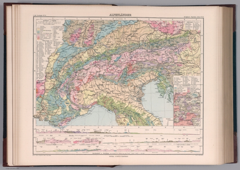
Author
[Berghaus, Heinrich, Berghaus, Hermann]
Full Title
Alpenlander. Entw. v. Herm. Berghaus 1889, Ausg. 1890. Gest. v. A. Herrmann. Gotha: Justus Perthes. (On upper margin) I. Abt. Geologie No. X. Berghaus' physikal atlas No. 10. (to Accompany) Berghaus' Physikalischer Atlas. (Begrundet 1836 durch Heinrich Berghaus) ... Gotha: Justus Perthes. 1892. (insets) Aus den Dolomiten n. v. Mojsisovics. (inset profiles) Durchschnitt der Ostalpan (with) Durchschnitt der Westalpen.
List No
4391.020
Note
Color lithograph map. Showing major cities, towns, rivers and river basins. Principal geological features are shown by color or symbols. Relief shown by contours and spot heights. Depth shown by isolines and soundings. Includes table of geologic formations and abbreviations. Prime meridian is Greenwich.
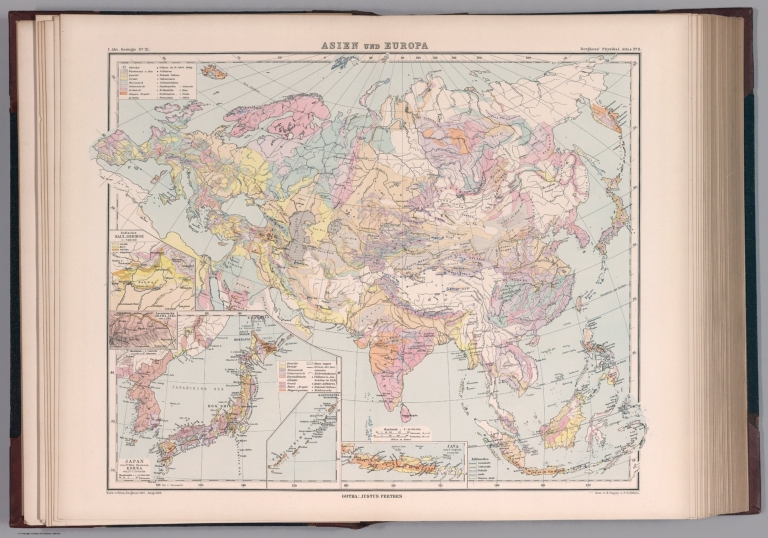
Author
[Berghaus, Heinrich, Berghaus, Hermann, Poppey, K., Grabhein, P.]
Full Title
Asien und Europa. Entw. v. Herm. Berghaus 1887, Ausg. 1889. Gest. v. K. Poppey u. P. Grabhein. Gotha: Justus Perthes. (On upper margin) I. Abt. Geologie No. XI. Berghaus' physikal atlas No. 11. (to Accompany) Berghaus' Physikalischer Atlas. (Begrundet 1836 durch Heinrich Berghaus) ... Gotha: Justus Perthes. 1892. (insets) Japan von Dr. Edm. Naumann, Korea von Dr. C. Gottsche. (with) Indisches Salz-Gebirge. (with) Lavastrom des Asama Jama von J.1783. (with) Java nach F. Junghulm.
List No
4391.021
Note
Color lithograph map. Showing major cities, towns, rivers, lakes and river basins. Principal geological features are shown by color or symbols. Relief shown by contours and spot heights. Depth shown by isolines and soundings. Includes table of geologic formations. Prime meridian is Greenwich.
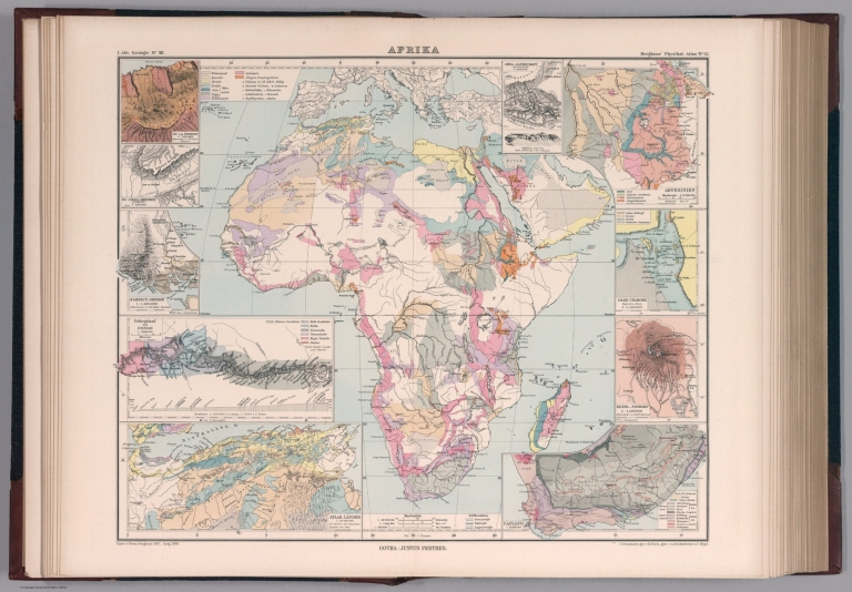
Author
[Berghaus, Heinrich, Berghaus, Hermann, Risch, M., Reichenbecher, A., Kogel, F.]
Full Title
Afrika. Entw. v. Herm. Berghaus 1887, Ausg. 1888. 7 Nebenkarten gez. v. M. Risch, gest. v. A. Reichenbecher & F. Kogel. Gotha: Justus Perthes. (On upper margin) I. Abt. Geologie No. XII. Berghaus' physikal atlas No. 12. (to Accompany) Berghaus' Physikalischer Atlas. (Begrundet 1836 durch Heinrich Berghaus) ... Gotha: Justus Perthes. 1892. (11 insets)
List No
4391.022
Note
Color lithograph map. Insets: Pic von Tenerife -- Bu-Chail-Gebirge (Algerien) -- Kamerun-Gebirge -- Gebirgslauf des Congo -- Atlas-Lander -- Capland -- Kilima-Ndsharo -- Oase Chargeh nach K. v. Zittel -- Abyssinien -- Amba-Landschaft -- Magdala. Showing major cities, ports, canals and river basins. Principal geological features are shown by color or symbols. Relief shown by contours and spot heights. Depth shown by isolines and soundings. Includes table of geologic formations. Prime meridian is Greenwich.
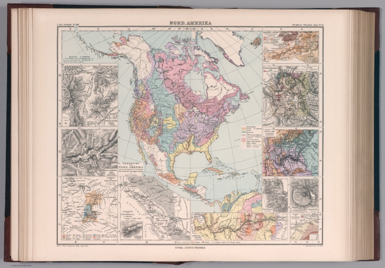
Author
[Berghaus, Heinrich, Berghaus, Hermann, Risch, M.]
Full Title
Nord-Amerika. Ubersicht von Nord-Amerika. Entw. v. Herm. Berghaus 1886, Ausg. 1887. Nebenkarten gez. v. M. Risch. Gotha: Justus Perthes. (On upper margin) I. Abt. Geologie No. XIII. Berghaus' physikal atlas No. 13. (to Accompany) Berghaus' Physikalischer Atlas. (Begrundet 1836 durch Heinrich Berghaus) ... Gotha: Justus Perthes. 1892. (12 insets).
List No
4391.023
Note
Color lithograph map. Insets: Virginia-Silber-Minen -- Das Yosemite-Thal -- Landenge von Tehuantepec -- Landenge von Nicaragua -- Die Krater des Turrialba -- Landenge von Panama -- Seeboden der New-York-Bay -- Popocatepetl -- Citlaltepetl -- Canons des Colorado --Yellowstone-National -Park -- Reykjanes und Geyser. Showing major cities, towns, rivers and river basins. Principal geological features are shown by color or symbols. Relief shown by contours and spot heights. Depth shown by isolines and soundings. Includes table. Prime meridian is Greenwich.
Author
[Berghaus, Heinrich, Berghaus, Hermann, Steinmann, G., Luddecke, R., Geyer, F.]
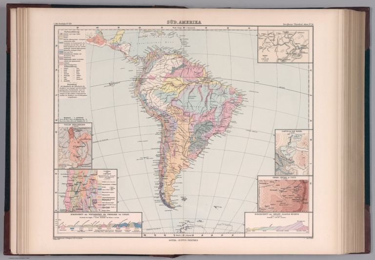
Full Title
Sud-Amerika. Ubersicht von Nord-Amerika. Bearb. v. G. Steinmann u. H. Berghaus, red. v. R. Luddecke. Ausgabe 1891. Gest. v. F. Geyer. Gotha: Justus Perthes. (On upper margin) I. Abt. Geologie No. XIV. Berghaus' physikal atlas No. 14. (to Accompany) Berghaus' Physikalischer Atlas. (Begrundet 1836 durch Heinrich Berghaus) ... Gotha: Justus Perthes. 1892. (7 insets).
List No
4391.024
Note
Color lithograph map. Insets: Vulcan Descabezado --Cordillere von Copiapo -- Durchschnitt des Westabhanges der Cordillere von Copiapo -- Minen von Callao -- Laguna de San Rafael -- Sierra Nevada de Cocui -- Durchschnitt des Sergipe-Alagoas Beckens. Showing lakes, rivers and river basins. Principal geological features are shown by color or symbols. Relief shown by contours and spot heights. Depth shown by isolines and soundings. Includes table and text. Prime meridian is Greenwich.
Author
[Berghaus, Heinrich, Berghaus, Hermann, Luddecke, R., Geyer, F.]
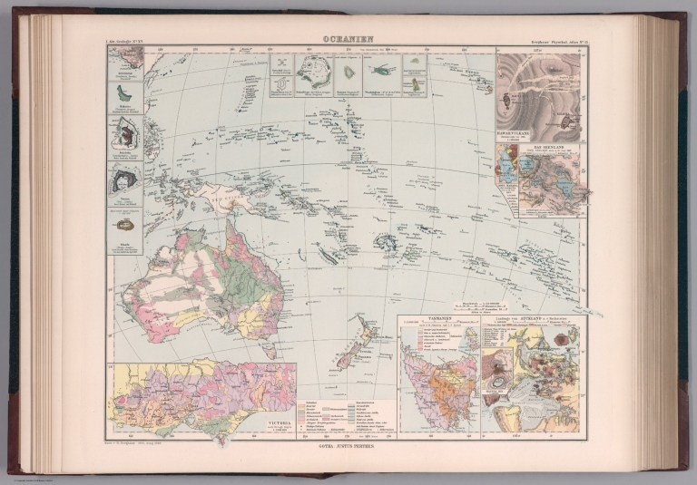
Full Title
Oceanien. Entw. v. H. Berghaus 1886, Ausg. 1888. Gotha: Justus Perthes. (On upper margin) I. Abt. Geologie No. XV. Berghaus' physikal atlas No. 15. (to Accompany) Berghaus' Physikalischer Atlas. (Begrundet 1836 durch Heinrich Berghaus) ... Gotha: Justus Perthes. 1892. (19 insets).
List No
4391.025
Note
Color lithograph map. Insets: Victoria -- Tasmanien -- Landenge von Auckland -- Maunga Rei -- Das Seenland -- Hawaii-Vulkane -- Roto-Mahana -- Honolulu -- Makatea -- Bolabola -- Totoya -- Niuafu -- Tova Riff -- Vuata Vatua -- Nukufetau -- Taiara -- Washington -- Jervis -- Enderbury.Showing majorrivers and river basins. Principal geological features are shown by color or symbols. Relief shown by contours and spot heights. Depth shown by isolines and soundings. Includes table of geologic formations. Prime meridian is Greenwich.
Author
Hayden, F.V.
Full Title
(Covers to) Department Of The Interior. United States Geological And Geographical Surveys Of The Territories. Geological And Geographical Atlas Of Colorado And Portions Of Adjacent Territory By F.V. Hayden, U.S. Geologist In Charge. Corrected To Date And Printed In Accordance With An Act Of Congress Approved February 9th 1881. Julius Bien, Lith.
List No
4576A
Author
Hayden, F.V.
Full Title
(Title Page to) Department Of The Interior. United States Geological And Geographical Surveys Of The Territories. Geological And Geographical Atlas Of Colorado And Portions Of Adjacent Territory By F.V. Hayden, U.S. Geologist In Charge. Corrected To Date And Printed In Accordance With An Act Of Congress Approved February 9th 1881. Julius Bien, Lith.
List No
4576B
Note
The second edition, folowing the first edition of 1877. Julius Bien was the lithographer. The maps are very detailed and present the best mapping of Colorado at the time. The maps have been updated to show completed and projected railroads. However, there are no changes to the topography from the first edition. Geology maps in full printed color. Atlas is bound into brown cloth covers stamped with the title "Geological And Geographical Atlas Of Colorado And Portions Of Adjacent Territory. Hayden." in gold.
Author
Hayden, F.V.
Full Title
(Index Page to) Department Of The Interior. United States Geological And Geographical Surveys Of The Territories. Geological And Geographical Atlas Of Colorado And Portions Of Adjacent Territory By F.V. Hayden, U.S. Geologist In Charge. Corrected To Date And Printed In Accordance With An Act Of Congress Approved February 9th 1881. Julius Bien, Lith.
List No
4576C
Note
Sheets noted. Legend is included giving contour intervals, scale of the maps, and attribution for the completed work.
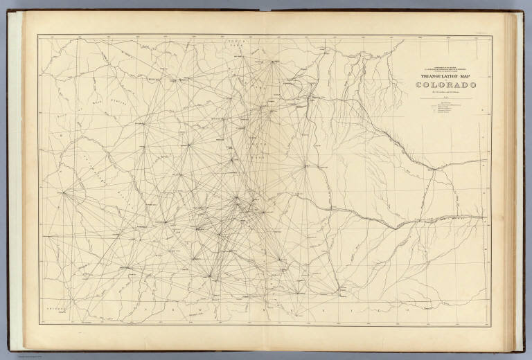
Author
Hayden, F.V.
Full Title
Triangulation Map of Colorado. By J.T. Gardner and A.D. Wilson. Department of the Interior, U.S. Geological and Geographical Survey of the Territories, F.V. Hayden, U.S. Geologist in Charge. Sheet I.
List No
4576.001
Note
Map without color. Map shows lines radiating from the many spots used for triangulation measurements. Railroad lines are also shown.
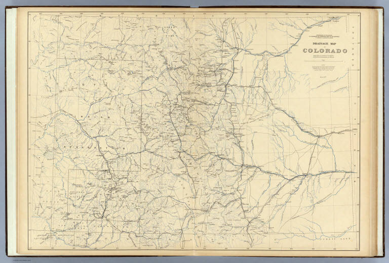
Author
Hayden, F.V.
Full Title
Drainage Map of Colorado. Topography by A.D. Wilson, G.R. Bechler, Henry Gannett, G.B. Chittenden and S.B. Ladd. Department of the Interior, U.S. Geological and Geographical Survey of the Territories, F.V. Hayden, U.S. Geologist in Charge. March 1877. Sheet II.
List No
4576.002
Note
Map shows the drainage of the state in blue with the railroads shown in black. Drainage that is dry during the majority of the year is noted by blue dots.
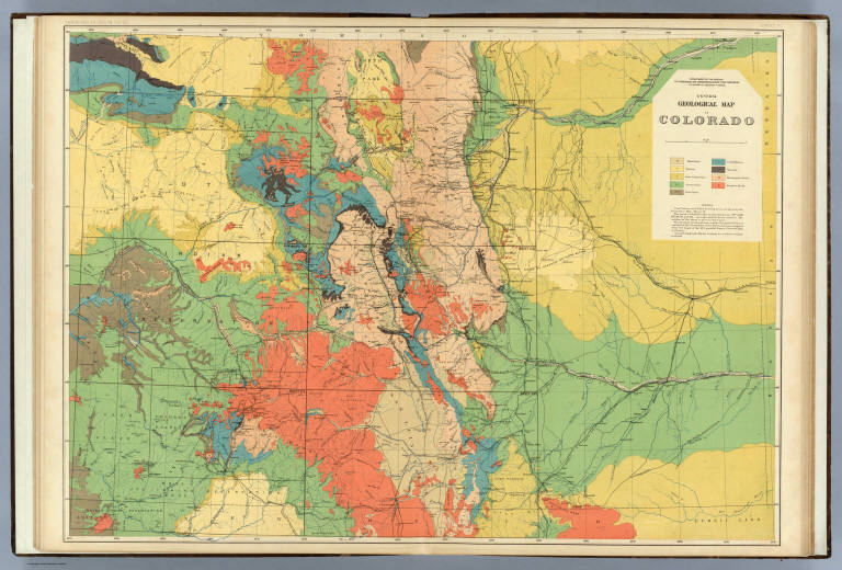
Author
Hayden, F.V.
Full Title
General Geological Map of Colorado. Department of the Interior, U.S. Geological and Geographical Survey of the Territories, F.V. Hayden, U.S. Geologist in Charge. Surveyed in 1873, '74, '75 & '76. Sheet IV.
List No
4576.004
Note
Map in full color. Map also serves as an index map for the geologic maps to follow.
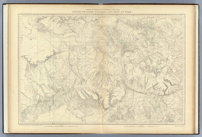
Author
Hayden, F.V.
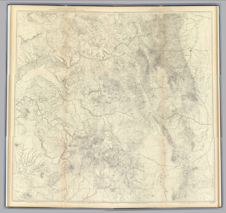
Full Title
North-western Colorado and part of Utah. U.S. Geological and Geographical Survey of the Territories. F.V. Hayden in Charge. S.B. Ladd, G.R. Bechler, H. Gannett and G.B. Chittenden, Topographical Assistants. Surveyed in 1874 & '76. Sheet V.
List No
4576.005
Note
Map without color.
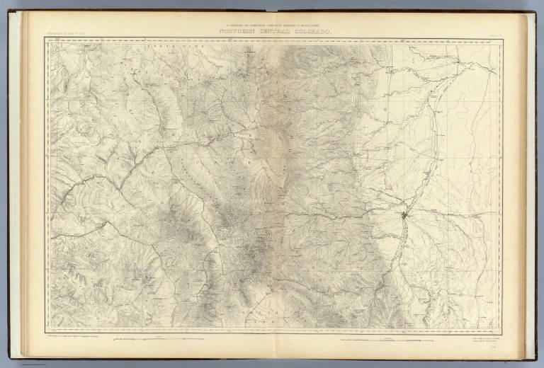
Author
Hayden, F.V.
Full Title
Northern Central Colorado. U.S. Geological and Geographical Survey of the Territories. F.V. Hayden in Charge. S.B. Ladd, G.R. Bechler, H. Gannett and G.B. Chittenden, Topographical Assistants. Surveyed in 1873, '74 & '75. Sheet VI.
List No
4576.006
Note
Map without color.
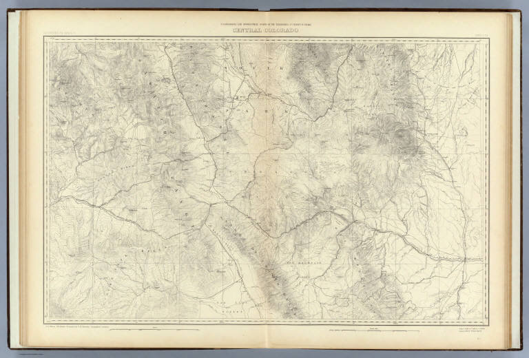
Author
Hayden, F.V.
Full Title
Central Colorado. U.S. Geological and Geographical Survey of the Territories. F.V. Hayden in Charge. A.D. Wilson, G.R. Bechler, H. Gannett and G.B. Chittenden, Topographical Assistants. Surveyed in 1874 & '75. Sheet VII.
List No
4576.007
Note
Map without color.
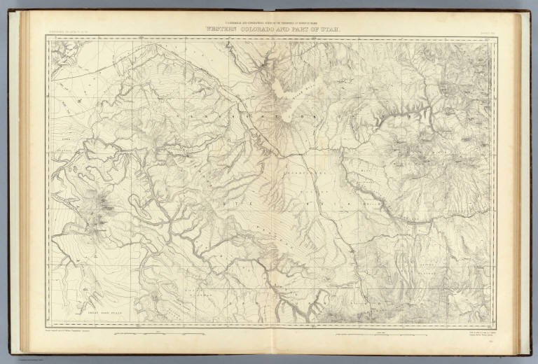
Author
Hayden, F.V.
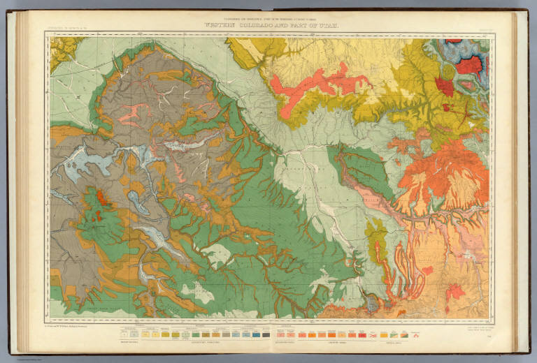
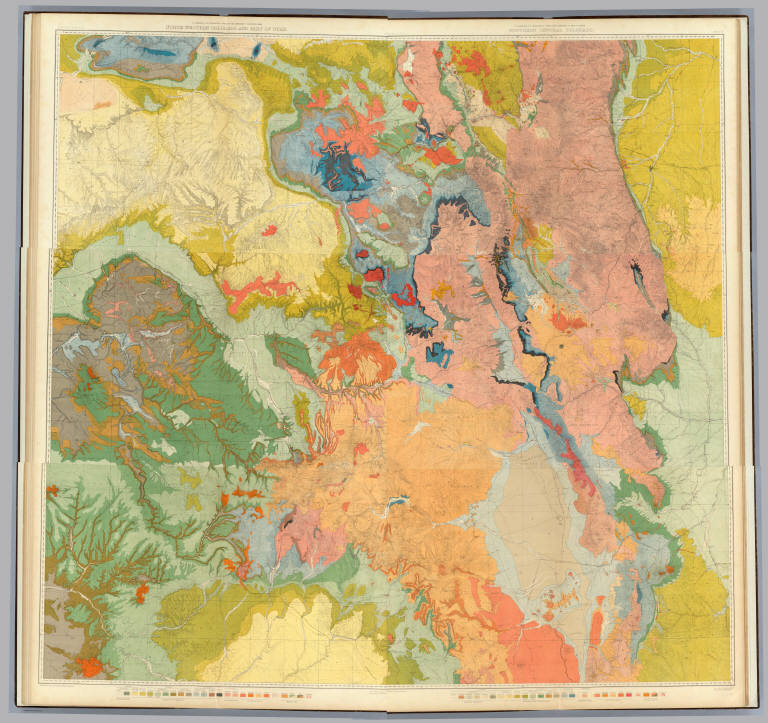
Full Title
Western Colorado and Part of Utah. U.S. Geological and Geographical Survey of the Territories. F.V. Hayden in Charge. H. Gannett and A.D. Wilson, Topographical Assistants. Surveyed in 1874-'75 & '76. Sheet VIII.
List No
4576.008
Note
Map without color.
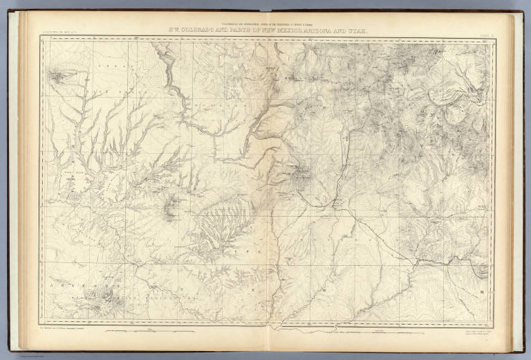
Author
Hayden, F.V.
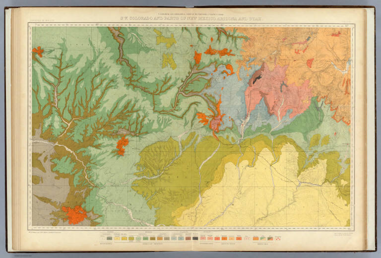
Full Title
SW. Colorado and Parts of New Mexico, Arizona and Utah. U.S. Geological and Geographical Survey of the Territories. F.V. Hayden in Charge. G.B. Chittenden and A.D. Wilson, Topographical Assistants. Surveyed in 1874 & '75. Sheet IX.
List No
4576.009
Note
Map without color.
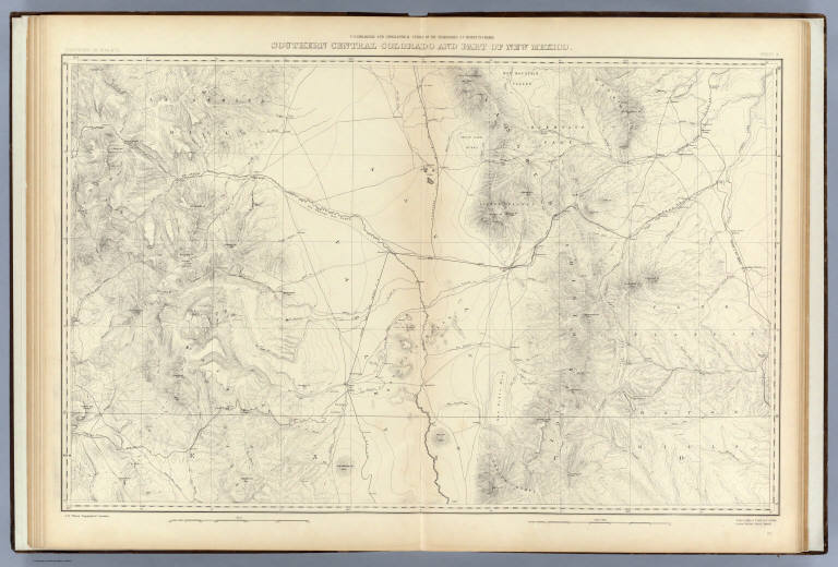
Author
Hayden, F.V.
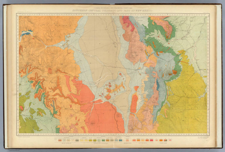
Full Title
Southern Central Colorado and Part of New Mexico. U.S. Geological and Geographical Survey of the Territories. F.V. Hayden in Charge. A.D. Wilson, Topographical Assistant. Surveyed in 1874 & '75. Sheet X.
List No
4576.010
Note
Map without color.
Author
Hayden, F.V.
Full Title
(Composite of) Colorado. Sheets V-X. U.S. Geological and Geographical Survey of the Territories. F.V. Hayden in Charge. A.D. Wilson, G.R. Bechler, H. Gannett, S.B. Ladd and G.B. Chittenden, Topographical Assistants. Surveyed in 1873-1876.
List No
4576.011
Note
Composite map of the state without color.
Author
Hayden, F.V.
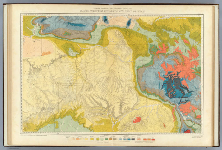
Full Title
North-western Colorado and part of Utah. U.S. Geological and Geographical Survey of the Territories. F.V. Hayden in Charge. A.R. Marvine, A.C. Peale, E.M. Endlich, and C.A. White, Geological Assistants. Surveyed in 1874 & '76. Sheet XI.
List No
4576.012
Note
Geologic map in full color.
Author
Hayden, F.V.
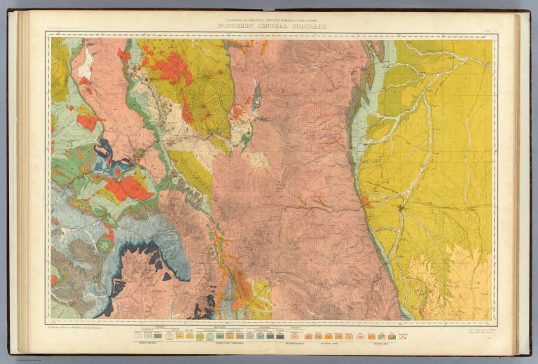
Full Title
Northern Central Colorado. U.S. Geological and Geographical Survey of the Territories. F.V. Hayden in Charge. A.R. Marvine, A.C. Peale, and Wm. H. Holmes, Geological Assistants. Surveyed in 1873, '74 & '75. Sheet XII.
List No
4576.013
Note
Geologic map in full color. Thermal areas, and gold and silver mining areas are noted.
Author
Hayden, F.V.
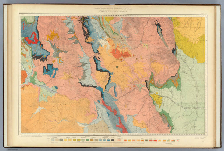
Full Title
Central Colorado. U.S. Geological and Geographical Survey of the Territories. F.V. Hayden in Charge. E.M. Endlich, A.C. Peale, and Wm. H. Holmes, Geological Assistants. Surveyed in 1873 '74 & '75. Sheet XIII.
List No
4576.014
Note
Geologic map in full color. Thermal areas, and gold and silver mining areas are noted.
Author
Hayden, F.V.
Full Title
Western Colorado and Part of Utah. U.S. Geological and Geographical Survey of the Territories. F.V. Hayden in Charge. A.C. Peale, and Wm. H. Holmes, Geological Assistants. Surveyed in 1874-'75 & '76. Sheet XIV.
List No
4576.015
Note
Geologic map in full color. Thermal areas, and gold and silver mining areas are noted.
Author
Hayden, F.V.
Full Title
SW. Colorado and Parts of New Mexico, Arizona and Utah. U.S. Geological and Geographical Survey of the Territories. F.V. Hayden in Charge. Wm. H. Holmes, and F.M. Endlich, Geological Assistants. Surveyed in 1874 & '75. Sheet XV.
List No
4576.016
Note
Geologic map in full color. Thermal areas, and gold and silver mining areas are noted.
Author
Hayden, F.V.
Full Title
Southern Central Colorado and Part of New Mexico. U.S. Geological and Geographical Survey of the Territories. F.V. Hayden in Charge. F.M. Endlich, Geological Assistant. Surveyed in 1874 & '75. Sheet XVI.
List No
4576.017
Note
Geologic map in full color. Thermal areas, and gold and silver mining areas are noted.
Author
Hayden, F.V.
Full Title
(Composite of) Colorado. Sheets XI-XVI. U.S. Geological and Geographical Survey of the Territories. F.V. Hayden in Charge. A.R. Marvine, A.C. Peale, F.M. Endlich, Wm. H. Holmes, and C.A. White, Geological Assistants. Surveyed in 1873-1876.
List No
4576.018
Note
Composite geologic map in full color. Thermal areas, and gold and silver mining areas are noted.
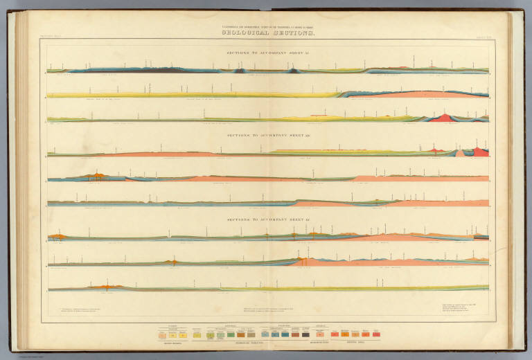
Author
Hayden, F.V.
Full Title
Geological Sections. U.S. Geological and Geographical Survey of the Territories. F.V. Hayden in Charge. Western Half. Sheet XVII.
List No
4576.019
Note
Includes sections to accompany sheets XI, XIV and XV. In full color.
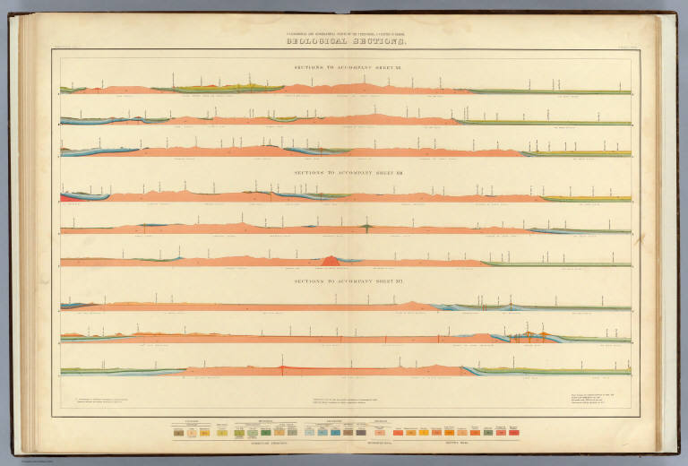
Author
Hayden, F.V.
Full Title
Geological Sections. U.S. Geological and Geographical Survey of the Territories. F.V. Hayden in Charge. Eastern Half. Sheet XVIII.
List No
4576.020
Note
Includes sections to accompany sheets XII, XIII and XVI. In full color.
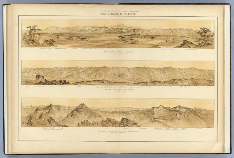
Author
[Hayden, F.V., Holmes, William Henry, 1846-1933]
Full Title
Panoramic Views. W.H. Holmes. U.S. Geological and Geographical Survey of the Territories. F.V. Hayden in Charge. Sheet XIX.
List No
4576.021
Note
Three views included: 1) The Pikes Peak Group; 2) View of the Sawatch Range; 3) Central Portion of the Elk Mountains.
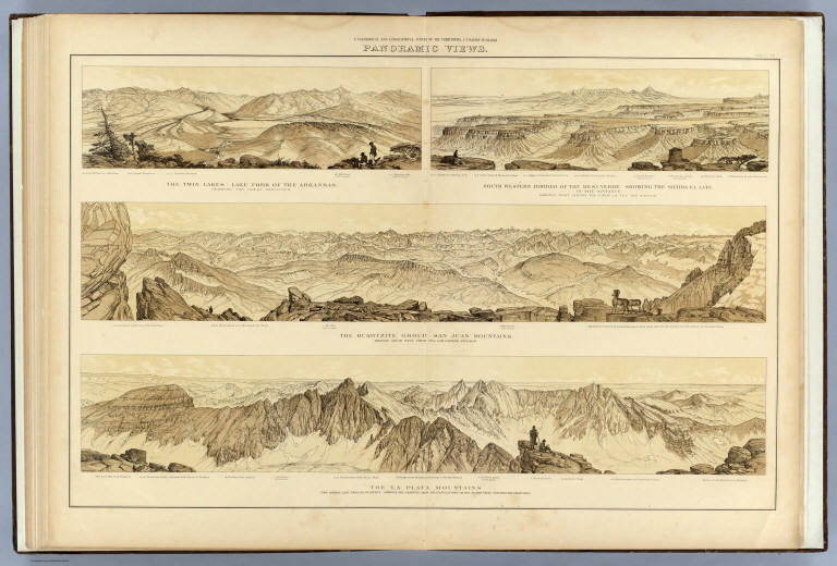
Author
[Hayden, F.V., Holmes, William Henry, 1846-1933]
Full Title
Panoramic Views. W.H. Holmes. U.S. Geological and Geographical Survey of the Territories. F.V. Hayden in Charge. Sheet XX.
List No
4576.022
Note
Four panoramic views: 1) The Twin Lakes - Lake Fork of the Arkansas; 2) South Western Border of the Mesa Verde Showing the Sierra El Late; 3) The Quartzite Group - San Juan Mountains; 4) The La Plata Mountains.
Author
Becker, George F.
Full Title
(Title Page to) Department Of The Interior, United States Geological Survey, J.W. Powell Director. Atlas to Accompany a Monograph on The Geology of the Quicksilver Deposits of the Pacific Slope By George F. Becker. Washington 1887. Giles Litho. & Liberty Printing Co. N.Y.
List No
4580B
Author
Becker, George F.
Full Title
(Table of Contents to) Department Of The Interior, United States Geological Survey, J.W. Powell Director. Atlas to Accompany a Monograph an The Geology of the Quicksilver Deposits of the Pacific Slope By George F. Becker. Washington 1887. Giles Litho. & Liberty Printing Co. N.Y.
List No
4580C
Author
Becker, George F.
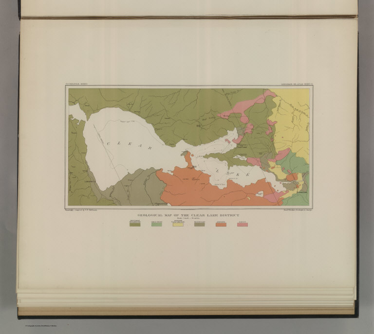
Full Title
Geological Map of the Clear Lake District. U.S. Geological Survey. Monograph XIII, Atlas Sheet III. Topography compiled by C.F. Hoffmann. Giles Litho. & Liberty Printing Co. Geo. F. Becker, Geologist in charge.
List No
4580.001
Note
Shows in color six classes of rock. Streams and settlements shown including borax works. Outline of Plate IV shown.
Author
Becker, George F.
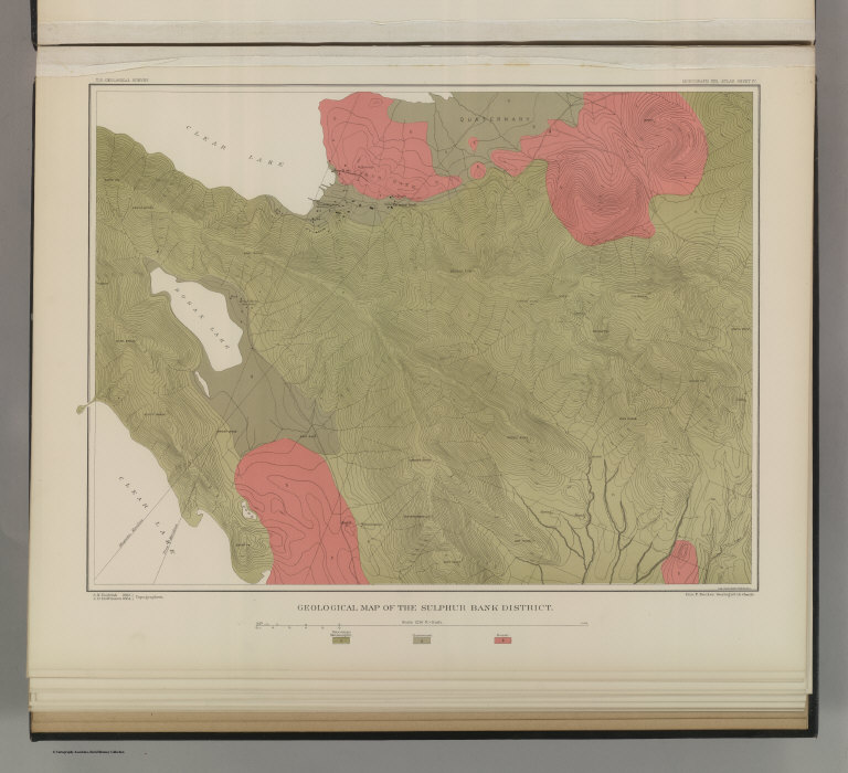
Full Title
Geological Map of the Sulphur Bank District. U.S. Geological Survey. Monograph XIII, Atlas Sheet IV. S.H. Bodfish 1882, J.D. Hoffman 1884, Topographers. Giles Litho. & Liberty Printing Co. Geo. F. Becker, Geologist in charge.
List No
4580.002
Note
Shows in color three classes of rock. Relief shown by 20-foot contour lines. Shows mines, streams, and settlements.
Author
Becker, George F.
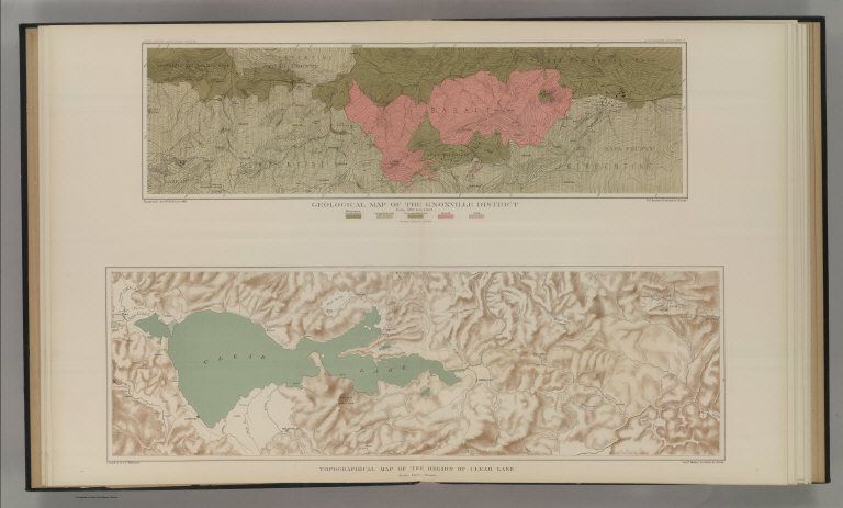
Full Title
Geological Map of the Knoxville District. U.S. Geological Survey. Monograph XIII, Atlas Sheet V. Topography by J.D. Hoffman 1883. Geo. F. Becker, Geologist in charge. Topographical Map of the Region of Clear Lake. Compiled by C.F. Hoffmann. Geo. F. Becker, Geologist in charge.
List No
4580.003
Note
Two maps on one sheet. Knoxville District map relief shown with 25-foot contours. Shows in color five classes of rock. Longitude and latitude shown. Scale 1:15,000. Clear Lake Region map shows topography with shaded relief, streams, mines, settlements, and roads. Scale 1:95,000. Outlines of Sulphur Bank District and Knoxville District shown.
Author
Becker, George F.
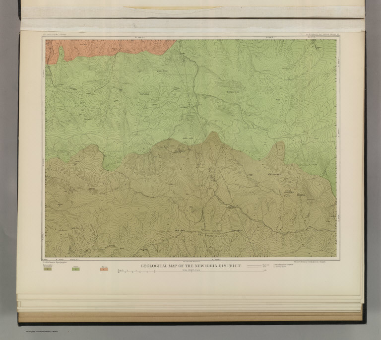
Full Title
Geological Map of the New Idria District. U.S. Geological Survey. Monograph XIII, Atlas Sheet VI. J.D. Hoffman, Topographer. Giles Litho. & Liberty Printing Co. N.Y. Geo. F. Becker, Geologist in charge.
List No
4580.004
Note
Shows in color three classes of rock. Relief shown by 40-foot contour lines. Shows streams, settlements, mines, trails, and roads.
Author
Becker, George F.
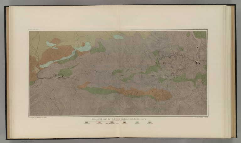
Full Title
Geological Map of the New Almaden Mining District. U.S. Geological Survey. Monograph XIII, Atlas Sheet VII. Topography by S.W. Bodfish and others. Giles Litho. & Liberty Printing Co. N.Y. Geo. F. Becker, Geologist in charge.
List No
4580.005
Note
Shows in color six classes of rock. Relief shown by 20-foot contour lines. Shows streams, settlements, mines, and roads.
Author
Becker, George F.
Full Title
Ore-Bodies and Topography of Mine-Hill, New Almaden. U.S. Geological Survey. Monograph XIII, Atlas Sheet VIII. Compiled by F. Reade 1885. Giles Litho. & Liberty Printing Co. N.Y. Geo. F. Becker, Geologist in charge.
List No
4580.006
Note
Shows in topography with 10-foot contours, ore bodies with cross-hatching, mine dumps with hachures, +streams, roads, tramways, tunnels and shafts.
Author
Becker, George F.
Full Title
Plan of the New Almaden Mine. U.S. Geological Survey. Monograph XIII, Atlas Sheet IX. Compiled by F. Reade 1885. Giles Litho. & Liberty Printing Co. N.Y. Geo. F. Becker, Geologist in charge.
List No
4580.007
Note
Shows depths, tunnels, drifts, galleries, and shafts in brilliant color.
Author
Becker, George F.
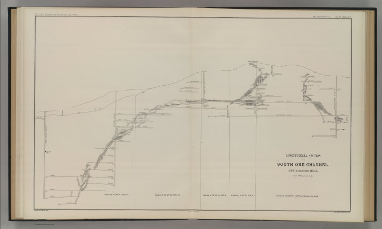
Full Title
Longitudinal Section of the South Ore Channel. New Almaden Mine. U.S. Geological Survey. Monograph XIII, Atlas Sheet X. Compiled by F. Reade 1885. Giles Litho. & Liberty Printing Co. N.Y. Geo. F. Becker, Geologist in charge.
List No
4580.008
Note
Shows depths, tunnels, drifts, galleries, and shafts.
Author
Becker, George F.
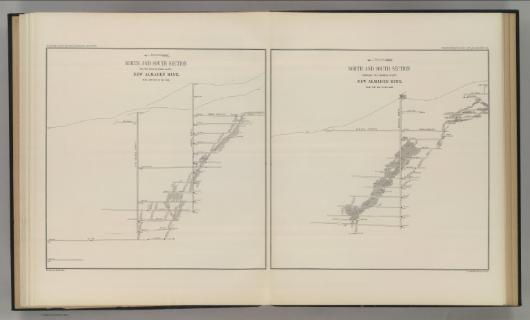
Full Title
North and South Section , 550 Feet West of Randol Shaft, New Almaden Mine. North and South Section through the Randol Shaft, New Almaden Mine. U.S. Geological Survey. Monograph XIII, Atlas Sheet XI. Compiled by F. Reade 1885. Geo. F. Becker, Geologist in charge.
List No
4580.009
Note
Two vertical sections on one sheet. Shows depths, tunnels, drifts, galleries, and shafts.
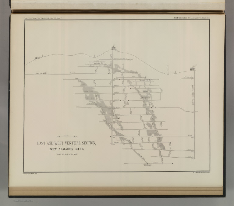
Author
Becker, George F.
Full Title
East and West Vertical Section, New Almaden Mine. U.S. Geological Survey. Monograph XIII, Atlas Sheet XII. Compiled by F. Reade 1885. Geo. F. Becker, Geologist in charge.
List No
4580.010
Note
Shows depths, tunnels, drifts, galleries, and shafts.
Author
Becker, George F.
Full Title
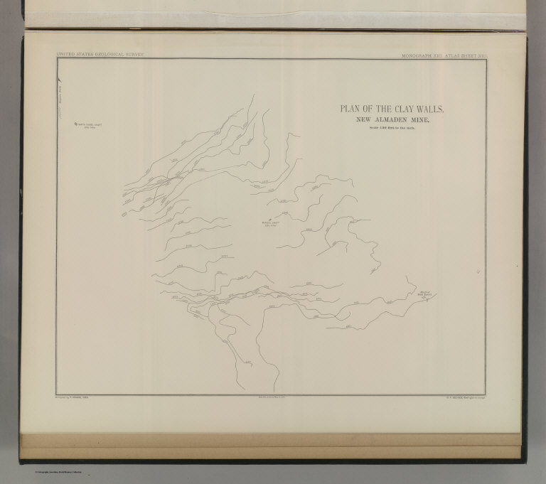
Plan of the Clay Walls, New Almaden Mine. U.S. Geological Survey. Monograph XIII, Atlas Sheet XIII. Compiled by F. Reade 1885. Giles Litho. & Liberty Printing Co. N.Y. Geo. F. Becker, Geologist in charge.
List No
4580.011
Note
Shows alignments of clay walls.
|