Scovel, James L. ; O'Brien, Emmett J Continental Glaciation. Eskers-Drumlins.... 1966 0889.067 Related Author
[Scovel, James L., O'Brien, Emmett J]
Full Title
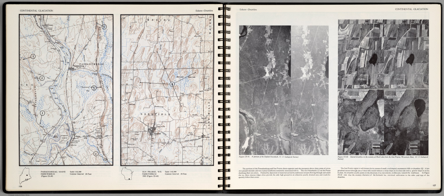
Continental Glaciation. Eskers-Drumlins. Passadumkeag, Maine. Sun Prairie, Wis. (on opposite page two views) A portion of the Enfiled Horsback ..., and Several drumlins in the vicinity of Mud Lake from the Sun Prairie, Wisconsin ...
List No
0889.067
Note
Two contour color maps, with location map on one page. Includes text. Relief shown by contours and spot heights.
Scovel, James L. ; O'Brien, Emmett J Shorelines. Wave Refraction. Point Reyes... 1966 0889.068 Related Author
[Scovel, James L., O'Brien, Emmett J]
Full Title
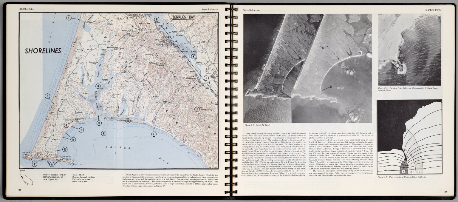
Shorelines. Wave Refraction. Point Reyes, Calif. (on opposite page) Three views.
List No
0889.068
Note
Contour color map, with location map and text. Views: aerial views of Point Reyes, Purisima Point, California, and Wave Fraction at Purisima Point, California. Relief shown by contours and spot heights.
Scovel, James L. ; O'Brien, Emmett J Shorelines. Shore Drifting and Wave-cut ... 1966 0889.069 Related Author
[Scovel, James L., O'Brien, Emmett J]
Full Title
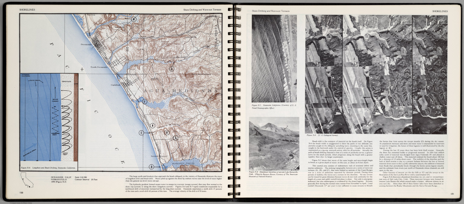
Shorelines. Shore Drifting and Wave-cut Terraces. Oceanside, Calif. (inset) Longshore and Beach Drifting, Oceanside, California. (on opposite page three views).
List No
0889.069
Note
Contour color map, with location map and text. Views: Oceanside, California; Abandoned shorlines of ancient Lake Bonnevile, Utah; and view showing series of wave-cut terraces (A), (B), and (C) ... Relief shown by contours and spot heights.
Scovel, James L. ; O'Brien, Emmett J Shorelines. Embayed-Resistant. Boothbay,... 1966 0889.070 Related Author
[Scovel, James L., O'Brien, Emmett J]
Full Title
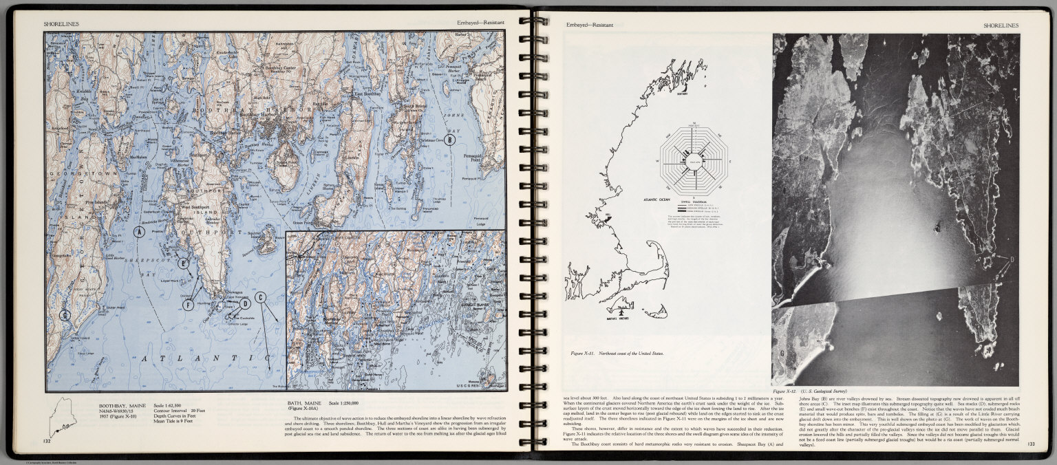
Shorelines. Embayed-Resistant. Boothbay, Maine. (inset) Bath, Maine. Scale 1:250,000. (drawing and view on opposite page).
List No
0889.070
Note
Contour color map, with location map and text. A drawing of Northeast coast of the United States, and view of Boothbay Coast. Relief shown by contours and spot heights.
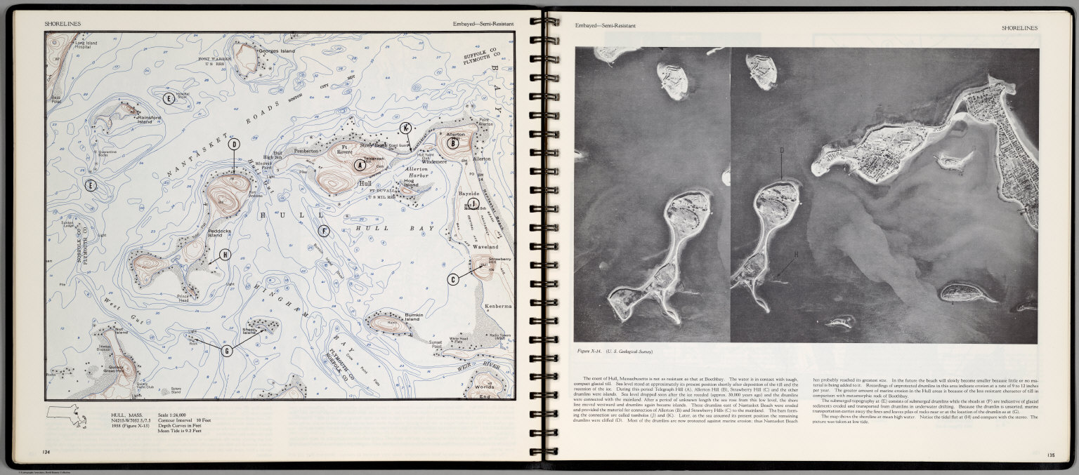
Scovel, James L. ; O'Brien, Emmett J Shorelines. Embayed-Semi-Resistant. Hull... 1966 0889.071 Related Author
[Scovel, James L., O'Brien, Emmett J]
Full Title
Shorelines. Embayed-Semi-Resistant. Hull, Mass. (on opposite page view of) The coast of Hull, Massachusetts.
List No
0889.071
Note
Contour color map, with location map and text. Relief shown by contours and spot heights.
Scovel, James L. ; O'Brien, Emmett J Shorelines. Embayed-Semi-Resistant. Hull... 1966 0889.072 Related Author
[Scovel, James L., O'Brien, Emmett J]
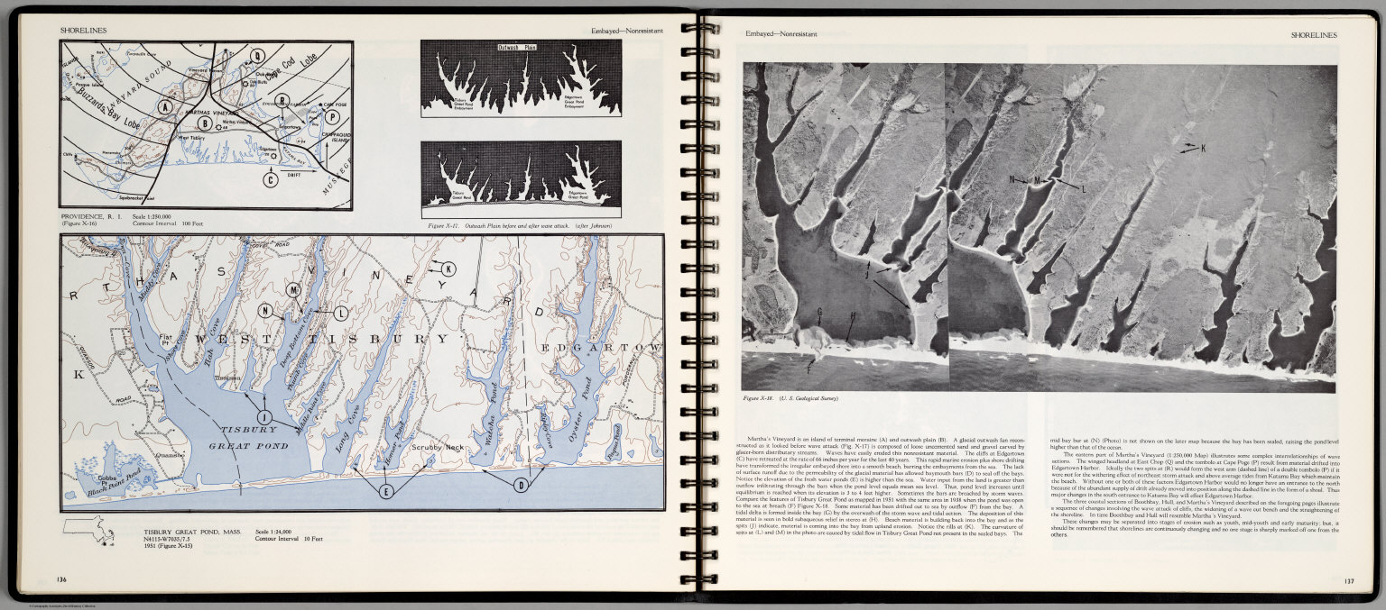
Full Title
Shorelines. Embayed-Nonresistant. Tisbury, Great Pond, Mass. (insets) Providence, R.I., and Outwash Plain before and after water attack. (with a view on opposite page).
List No
0889.072
Note
Contour color map, with location map and text. Inset shows the view of Tisbury Great Pond. Relief shown by contours and spot heights.
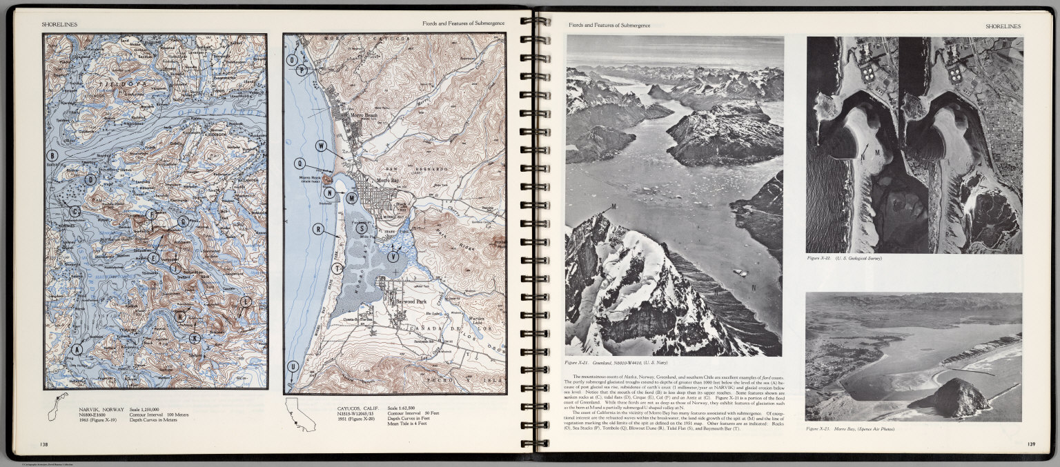
Scovel, James L. ; O'Brien, Emmett J Shorelines. Fiords and Features of Subme... 1966 0889.073 Related Author
[Scovel, James L., O'Brien, Emmett J]
Full Title
Shorelines. Fiords and Features of Submergence. Narvik, Norway. Cayucos, Calif. Scale 1:62,500. (insets) Providence, R.I., and Outwash Plain before and after water attack. (with three views on opposite page).
List No
0889.073
Note
Two contour color maps, with location map and text. View of Greenland, and two views of Morro Bay, California. Relief shown by contours and spot heights.
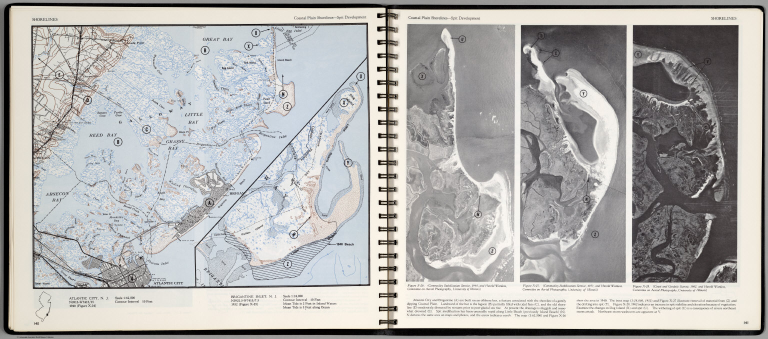
Scovel, James L. ; O'Brien, Emmett J Shorelines. Coastal Plain Shorlines-Spli... 1966 0889.074 Related Author
[Scovel, James L., O'Brien, Emmett J]
Full Title
Shorelines. Coastal Plain Shorlines-Split Development. Atlantic City, N.J. (inset map) Brigantine Inlet, N.J. (with three aerial views on opposite page).
List No
0889.074
Note
Contour color maps, with location map and text. Aerial views of Atlantic city and Brigantine. Relief shown by contours and spot heights.
Scovel, James L. ; O'Brien, Emmett J Shorelines. Coastal Plain Shorlines. Ara... 1966 0889.075 Related Author
[Scovel, James L., O'Brien, Emmett J]
Full Title
Shorelines. Coastal Plain Shorlines. Aransas Pass, Texas. (inset map) Corpus Christi. (on opposite page) Jacksonville Beach, Fla. Scale 1:24,000..
List No
0889.075
Note
Contour color maps, with location map and text. Relief shown by contours and spot heights.
Scovel, James L. ; O'Brien, Emmett J Shorelines. Volcanic Shorelines and Reef... 1966 0889.076 Related Author
[Scovel, James L., O'Brien, Emmett J]
Full Title
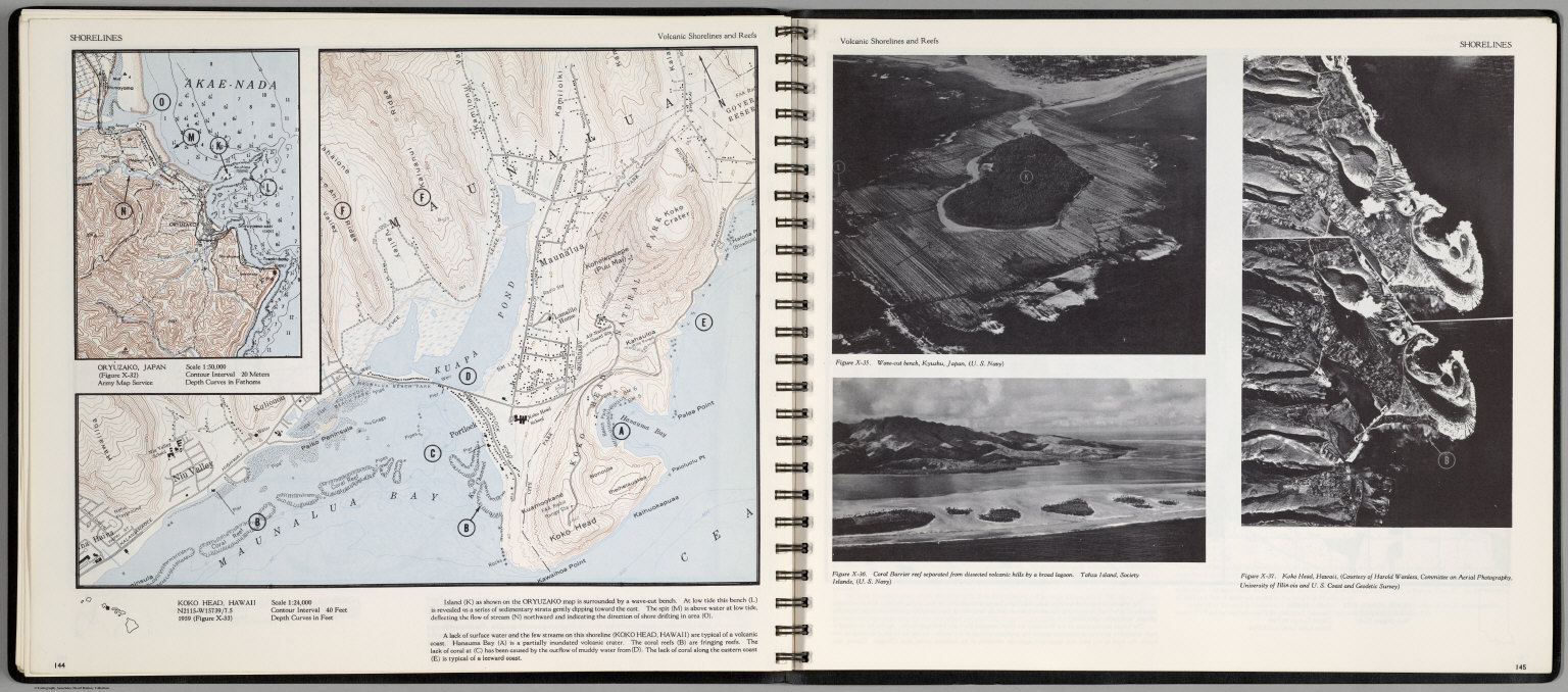
Shorelines. Volcanic Shorelines and Reefs. Koko Head, Hawaii. (inset map) Oryuzako, Japan. (on opposite page three views) Wave-cut bench, Kyushu, Japan. Coral Barrier reef separated from dissected volcanic hills by a broad lagoon. Koko Head, Hawaii ...
List No
0889.076
Note
Contour color maps, with location map and text. Relief shown by contours and spot heights.
Scovel, James L. ; O'Brien, Emmett J Landforms Due to Wind. Coastal Dunes-Blo... 1966 0889.077 Related Author
[Scovel, James L., O'Brien, Emmett J]
Full Title
Landforms Due to Wind. Coastal Dunes-Blowouts. Dune Acres, Ind. (with aerial view on opposite page).
List No
0889.077
Note
Contour color map, with location map and text. Relief shown by contours and spot heights.
Scovel, James L. ; O'Brien, Emmett J Eolian Activity. Coastal Dunes-Transvers... 1966 0889.078 Related Author
[Scovel, James L., O'Brien, Emmett J]
Full Title
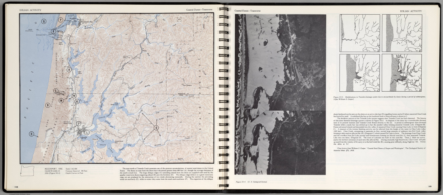
Eolian Activity. Coastal Dunes-Transverse. Reedsport, Ore. (with aerial view on opposite page).
List No
0889.078
Note
Contour color map, with location map and text. Inset: Modifications in Tenmile drainage system ... Relief shown by contours and spot heights.
Scovel, James L. ; O'Brien, Emmett J Eolian Activity. Barchan Dune. Moses Lak... 1966 0889.079 Related Author
[Scovel, James L., O'Brien, Emmett J]
Full Title
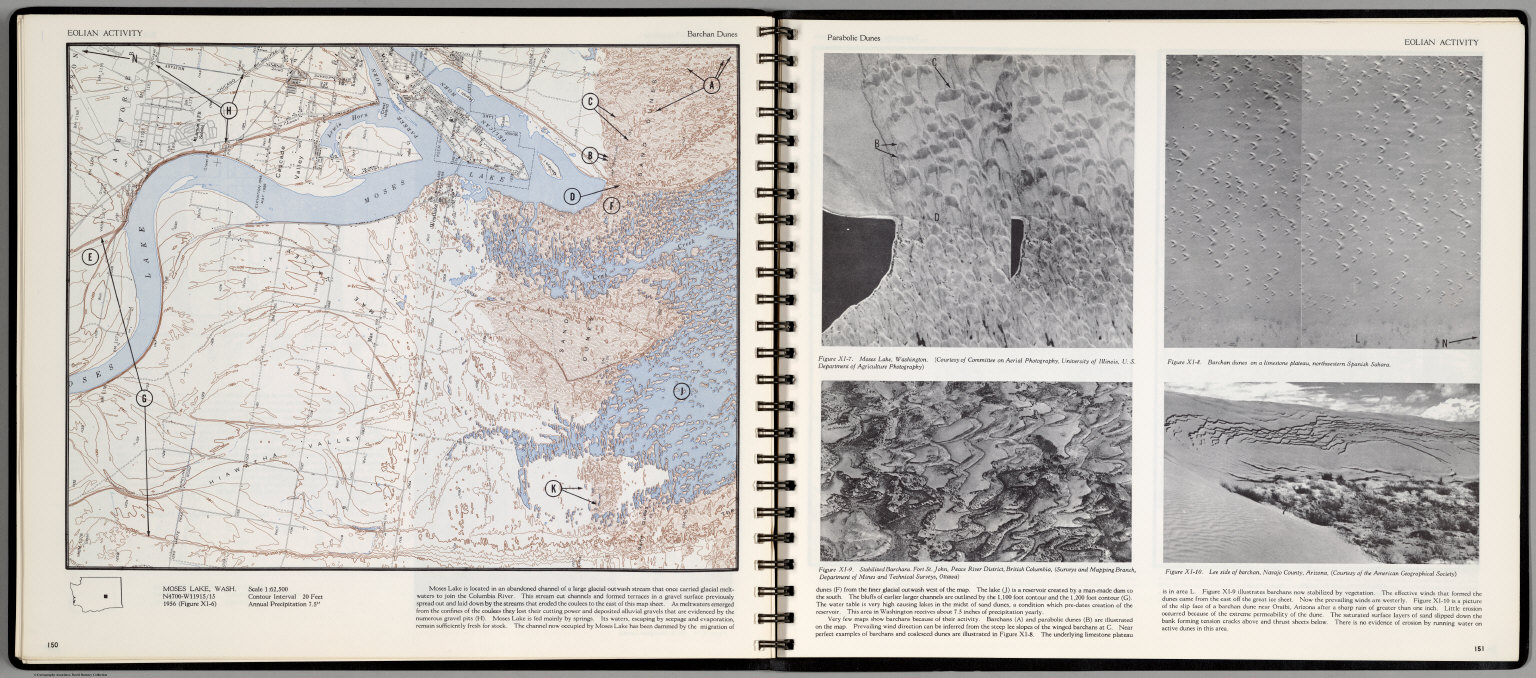
Eolian Activity. Barchan Dune. Moses Lake, Wash. (with aerial view on opposite page).
List No
0889.079
Note
Contour color map, with location map and text. Aerial views of Moses Lake, Washington, Fort St. Jon, Peace River District, British Columbia, Barchan dunes on a limestone plateau, northwestern Spanish Sahara, and Lee side of barchan, Navajo County, Arizona ... Relief shown by contours and spot heights.
Scovel, James L. ; O'Brien, Emmett J Eolian Activity. Transverse and Paraboli... 1966 0889.080 Related Author
[Scovel, James L., O'Brien, Emmett J]
Full Title
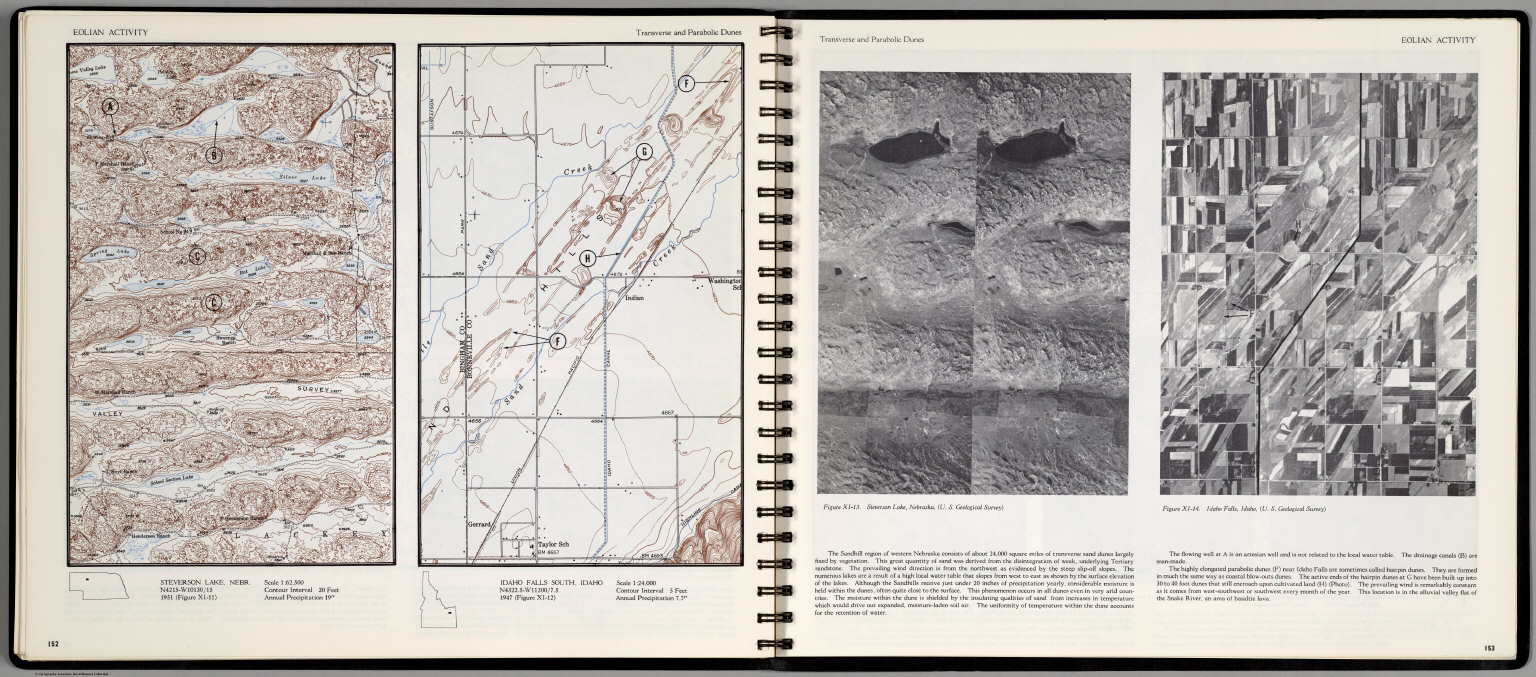
Eolian Activity. Transverse and Parabolic Dunes. Steverson Lake, Nebr. Idaho Falls South, Idaho. Scale 1:24,000. (with aerial view on opposite page) Steverson Lake Nebraska, and Idaho Falls, Idaho.
List No
0889.080
Note
Contour color maps, with location map and text. Relief shown by contours and spot heights.
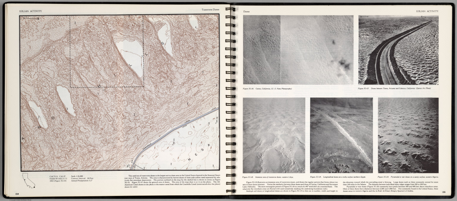
Scovel, James L. ; O'Brien, Emmett J Eolian Activity. Transverse Dunes. Cactu... 1966 0889.081 Related Author
[Scovel, James L., O'Brien, Emmett J]
Full Title
Eolian Activity. Transverse Dunes. Cactus, Calif. (with aerial views on opposite page)
List No
0889.081
Note
Contour color maps, with location map and text. Aerial views: Cactus, California, Dunes between Yuma, Arizona and Calexico, California, Immense area of transverse dunes, western Libya, Longitudinal dunes on a rocky surface northern Egypt, and Pyramid or star dunes on a sandy surface, western Algeria. Relief shown by contours and spot heights.
Author
[Murchison, Roderick Impey, Sir, 1792-1871, Society for the Diffusion of Useful Knowledge (Great Britain)]
Full Title
Geological map of England and Wales. Published under the superintendence of the Society for the Diffusion of Useful Knowledge. 1843. Arranged by Roderick Impey Murchison ... S.P. Woodward del. Col(oure)d. by T. Malby. J. & C. Walker sculpt. Published by Chapman & Hall 186 Strand Decr. 15th. 1843. (1844)
List No
0890.012
Note
Engraved map. Geologic units hand col. Also shows railroads, canals, navigable rivers and dip of strata.
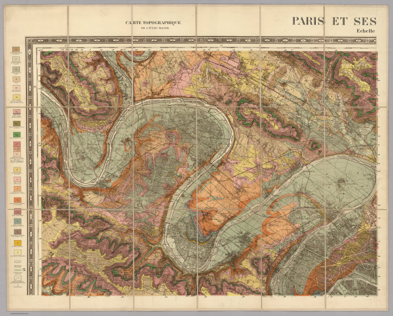
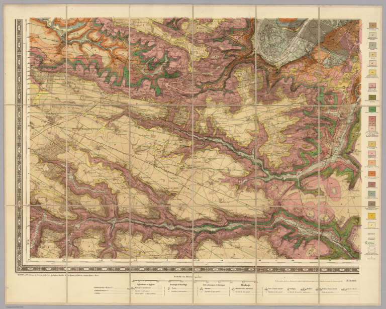
Author
Service Geologique Des Mines (France)
Full Title
(Covers to) Paris Et Ses Environs. Carte Geologique Detaillee. Carte Topographique De L'Etat Major ... Baundry Et Cie. editeurs du Service de la Carte geologique detaillee de la France, 15, Rue des Saints-Peres a Paris. Erhard freres, imprimeurs, 35 bis, Rue Denfert-Rochereau, Paris. (embossed stamp) Service Geologique Des Mines. Ministere Des Travaux Publics. Mai 1890.
List No
0893A
Note
This map has incredible detail. 4 sheets, each dissected into 18 sections, mounded and edged with linen. With printed full color by geological formations. Each sheets folds with paste down label on the end sheet reading "Carte Geologique Paris Et Ses Environs. A L'Echelle De 1/40,000. Baudry Et Cie, Editeurs, Paris, 15, rue des Saints-Peres. Liege, 7 rue des Dominicains ..." Outer case is a new tan cloth slip case 21.5x13.5 with "Carte Geologique - Paris Service Geologique 1890" stamped in gilt on the spine.
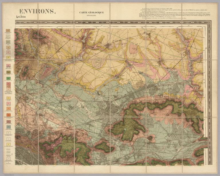
Author
Service Geologique Des Mines (France)
Full Title
(Nord-Ouest) Paris Et Ses Environs. Carte Geologique Detaillee. Carte Topographique De L'Etat Major ... Baundry Et Cie. editeurs du Service de la Carte geologique detaillee de la France, 15, Rue des Saints-Peres a Paris. Erhard freres, imprimeurs, 35 bis, Rue Denfert-Rochereau, Paris. (embossed stamp) Service Geologique Des Mines. Ministere Des Travaux Publics. Mai 1890.
List No
0893.001
Note
This map has incredible detail. 4 sheets, each dissected into 18 sections, mounded and edged with linen. With printed full color by geological formations. Each sheets folds with paste down label on the end sheet reading "Carte Geologique Paris Et Ses Environs. A L'Echelle De 1/40,000. Baudry Et Cie, Editeurs, Paris, 15, rue des Saints-Peres. Liege, 7 rue des Dominicains ..." Outer case is a new tan cloth slip case 21.5x13.5 with "Carte Geologique - Paris Service Geologique 1890" stamped in gilt on the spine.
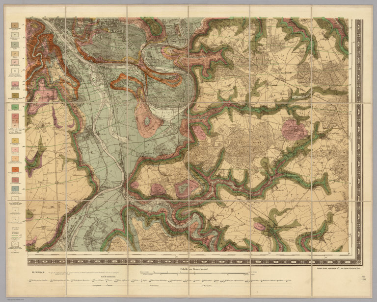
Author
Service Geologique Des Mines (France)
Full Title
(Nord-Est) Paris Et Ses Environs. Carte Geologique Detaillee. Carte Topographique De L'Etat Major ... Baundry Et Cie. editeurs du Service de la Carte geologique detaillee de la France, 15, Rue des Saints-Peres a Paris. Erhard freres, imprimeurs, 35 bis, Rue Denfert-Rochereau, Paris. (embossed stamp) Service Geologique Des Mines. Ministere Des Travaux Publics. Mai 1890.
List No
0893.002
Note
This map has incredible detail. 4 sheets, each dissected into 18 sections, mounded and edged with linen. With printed full color by geological formations. Each sheets folds with paste down label on the end sheet reading "Carte Geologique Paris Et Ses Environs. A L'Echelle De 1/40,000. Baudry Et Cie, Editeurs, Paris, 15, rue des Saints-Peres. Liege, 7 rue des Dominicains ..." Outer case is a new tan cloth slip case 21.5x13.5 with "Carte Geologique - Paris Service Geologique 1890" stamped in gilt on the spine.
Author
Service Geologique Des Mines (France)
Full Title
(Sud-Est) Paris Et Ses Environs. Carte Geologique Detaillee. Carte Topographique De L'Etat Major ... Baundry Et Cie. editeurs du Service de la Carte geologique detaillee de la France, 15, Rue des Saints-Peres a Paris. Erhard freres, imprimeurs, 35 bis, Rue Denfert-Rochereau, Paris. (embossed stamp) Service Geologique Des Mines. Ministere Des Travaux Publics. Mai 1890.
List No
0893.003
Note
This map has incredible detail. 4 sheets, each dissected into 18 sections, mounded and edged with linen. With printed full color by geological formations. Each sheets folds with paste down label on the end sheet reading "Carte Geologique Paris Et Ses Environs. A L'Echelle De 1/40,000. Baudry Et Cie, Editeurs, Paris, 15, rue des Saints-Peres. Liege, 7 rue des Dominicains ..." Outer case is a new tan cloth slip case 21.5x13.5 with "Carte Geologique - Paris Service Geologique 1890" stamped in gilt on the spine.
Author
Service Geologique Des Mines (France)
Full Title
(Sud-Ouest) Paris Et Ses Environs. Carte Geologique Detaillee. Carte Topographique De L'Etat Major ... Baundry Et Cie. editeurs du Service de la Carte geologique detaillee de la France, 15, Rue des Saints-Peres a Paris. Erhard freres, imprimeurs, 35 bis, Rue Denfert-Rochereau, Paris. (embossed stamp) Service Geologique Des Mines. Ministere Des Travaux Publics. Mai 1890.
List No
0893.004
Note
This map has incredible detail. 4 sheets, each dissected into 18 sections, mounded and edged with linen. With printed full color by geological formations. Each sheets folds with paste down label on the end sheet reading "Carte Geologique Paris Et Ses Environs. A L'Echelle De 1/40,000. Baudry Et Cie, Editeurs, Paris, 15, rue des Saints-Peres. Liege, 7 rue des Dominicains ..." Outer case is a new tan cloth slip case 21.5x13.5 with "Carte Geologique - Paris Service Geologique 1890" stamped in gilt on the spine.
Author
[Chamberlin, Thomas Chrowder, 1842-1928, Snyder, Van Vechten & Co.]
Full Title
Geological map of Wisconsin. Compiled by T.C. Chamberlin, State Geologist. Published by Snyder, Van Vechten & Co., Milwaukee. Copyright 1877, by Snyder, Van Vechten & Co.
List No
0936.009
Note
Col. lithographed map.
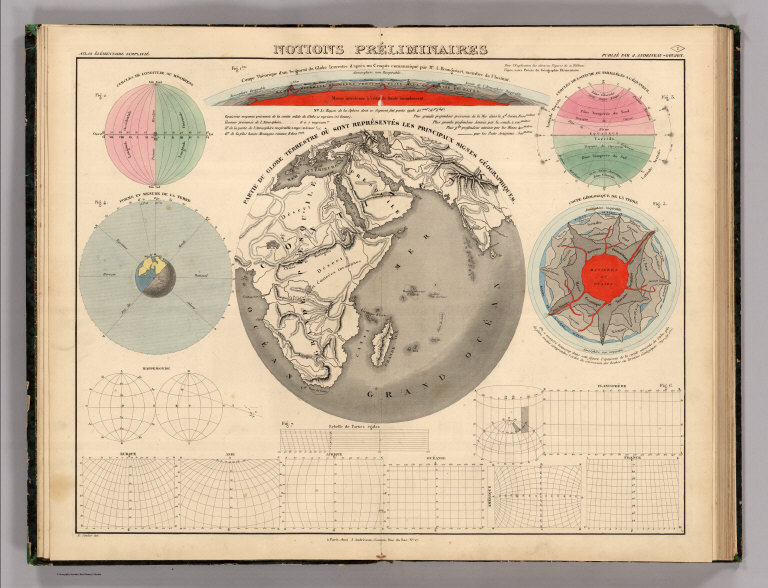
Author
[Andriveau-Goujon, J., Soulier, E.]
Full Title
Notions Preliminaires. Atlas Elementaire Simplifie. Publie par J. Andriveau-Goujon.
List No
0940.002
Note
Shows map projections, symbols, longitude, latitude, and molten core of the earth.
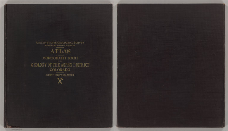
Author
Spurr, Josiah Edward
Full Title
(Covers to) Department Of The Interior, United States Geological Survey, Charles D. Walcott, Director. Atlas To Accompany Monograph XXXI On The Geology Of The Aspen District Colorado By Josiah Edward Spurr, Samuel Franklin Emmons, Geologist In Charge. Washington 1898. Julius Bien & Co. Lith. N.Y.
List No
0942A
Note
Bound in original dark brown cloth covered boards with "United States Geological Survey, Charles D. Walcott, Director. Atlas To Accompany Monograph XXXI On The Geology Of The Aspen District Colorado. Josiah Edward Spurr" stamped in gilt.
Author
Spurr, Josiah Edward
Full Title
(Title Page to) Department Of The Interior, United States Geological Survey, Charles D. Walcott, Director. Atlas To Accompany Monograph XXXI On The Geology Of The Aspen District Colorado By Josiah Edward Spurr, Samuel Franklin Emmons, Geologist In Charge. Washington 1898. Julius Bien & Co. Lith. N.Y.
List No
0942B
Author
Spurr, Josiah Edward
Full Title
(Table of Contents to) Department Of The Interior, United States Geological Survey, Charles D. Walcott, Director. Atlas To Accompany Monograph XXXI On The Geology Of The Aspen District Colorado By Josiah Edward Spurr, Samuel Franklin Emmons, Geologist In Charge. Washington 1898. Julius Bien & Co. Lith. N.Y.
List No
0942C
Author
Spurr, Josiah Edward
Full Title
(Legend to) Department Of The Interior, United States Geological Survey, Charles D. Walcott, Director. Atlas To Accompany Monograph XXXI On The Geology Of The Aspen District Colorado By Josiah Edward Spurr, Samuel Franklin Emmons, Geologist In Charge. Washington 1898. Julius Bien & Co. Lith. N.Y.
List No
0942D
Note
Provides a description of the atlas and geology of the Aspen Mining District, Colorado.
Author
Spurr, Josiah Edward
Full Title
Aspen District Sheet. Geology Sheet VI . U. S. Geological Survey, Charles D. Walcott, Director. Monograph XXXI. A.H. Thompson, Geographer. Morris Bien, Topographer in charge. Triangulation by Morris Bien. Topography by F.F. Grove. Surveyed in 1891. S.F. Emmons, Geologist in charge. Geology by J.E. Spurr. Assistant, G.W. Tower. Julius Bien & Co. Lith. N.Y. (1898)
List No
0942.003
Note
Topography shown by 100-foot contours. Shows streams, mines, roads, trails, and settlements. Geology shown in 16 colored classes, and faults. Shows alignment of cross-sections presented on the subsequent sheet.
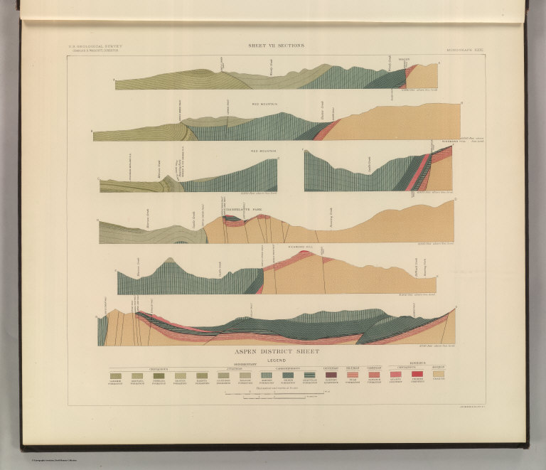
Author
Spurr, Josiah Edward
Full Title
Sheet VII Sections. U. S. Geological Survey, Charles D. Walcott, Director. Monograph XXXI. Julius Bien & Co. Lith. N.Y. (1898)
List No
0942.004
Note
Geology shown in 16 colored classes, and faults.
Author
Spurr, Josiah Edward
Full Title
Aspen Special Sheet. Geology Sheet IX. U. S. Geological Survey, Charles D. Walcott, Director. Monograph XXXI. A.H. Thompson, Geographer. Morris Bien, Topographer in charge. Triangulation by Morris Bien. Topography by F.F. Grove. Surveyed in 1891. S.F. Emmons, Geologist in charge. Geology by J.E. Spurr. Assistant, G.W. Tower. Julius Bien & Co. Lith. N.Y. (1898)
List No
0942.006
Note
Geology shown in color in 11 classes, and faults. Cross section alignments provided in next sheet shown here.
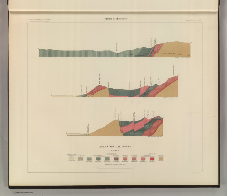
Author
Spurr, Josiah Edward
Full Title
Aspen Special Sheet. Sheet X Sections. U. S. Geological Survey, Charles D. Walcott, Director. Monograph XXXI. Julius Bien & Co. Lith. N.Y. (1898)
List No
0942.007
Note
Geologic cross-sections shown in color in 11 classes, and faults.
Author
Spurr, Josiah Edward
Full Title
Tourtelotte Park Special. Geology Sheet XII. U. S. Geological Survey, Charles D. Walcott, Director. Monograph XXXI. A.H. Thompson, Geographer. Morris Bien, Topographer in charge. Triangulation by Morris Bien. Topography by F.F. Grove. Surveyed in 1891. S.F. Emmons, Geologist in charge. Geology by J.E. Spurr. Assistant, G.W. Tower. Julius Bien & Co. Lith. N.Y. (1898)
List No
0942.009
Note
Geology shown in color with 10 classes of rock, and faults. Shows alignment of cross-sections on following sheets.
Author
Spurr, Josiah Edward
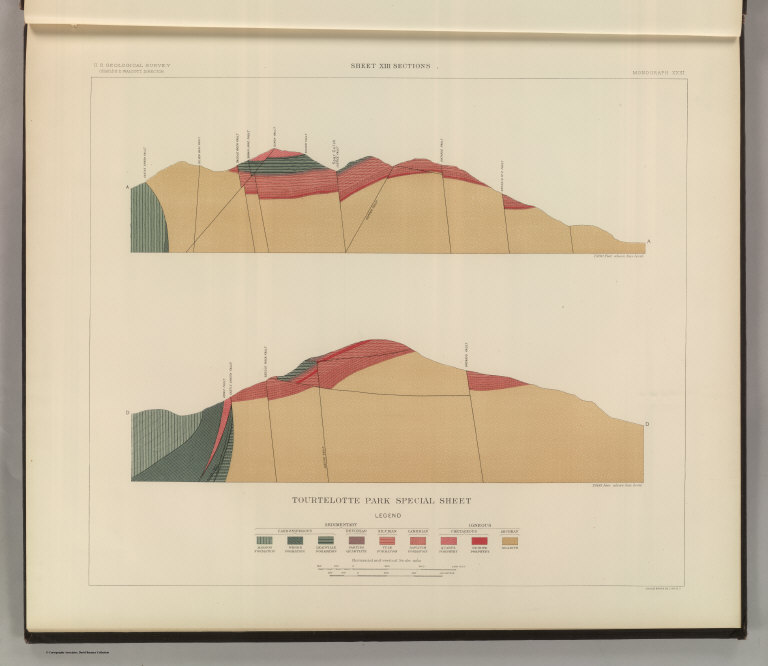
Full Title
Tourtelotte Park Special Sheet. Sheet XIII Sections. U. S. Geological Survey, Charles D. Walcott, Director. Monograph XXXI. Julius Bien & Co. Lith. N.Y. (1898)
List No
0942.010
Note
Geologic cross-sections shown in color in 9 classes, and faults.
Author
Spurr, Josiah Edward
Full Title
Tourtelotte Park Special Sheet. Sheet XIV Sections. U. S. Geological Survey, Charles D. Walcott, Director. Monograph XXXI. Julius Bien & Co. Lith. N.Y. (1898)
List No
0942.011
Note
Geologic cross-sections shown in color in 9 classes, and faults.
Author
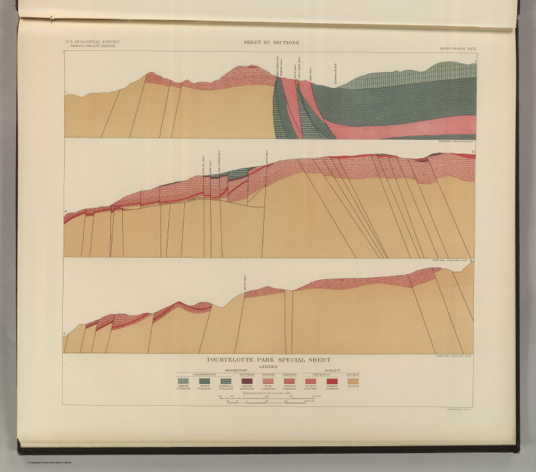
Spurr, Josiah Edward
Full Title
Tourtelotte Park Special Sheet. Sheet XV Sections. U. S. Geological Survey, Charles D. Walcott, Director. Monograph XXXI. Julius Bien & Co. Lith. N.Y. (1898)
List No
0942.012
Note
Geologic cross-sections shown in color in 9 classes, and faults.
Author
Spurr, Josiah Edward
Full Title
Hunter Park Special Sheet. Geology Sheet XVII . U. S. Geological Survey, Charles D. Walcott, Director. Monograph XXXI. A.H. Thompson, Geographer. F.M Douglas, Topographer in charge. Triangulation by E.M. Douglas. Topography by (R.C. McKinney). S.F. Emmons, Geologist in Charge. Geology by J.E. Spurr. Assistant, G.W. Tower. Surveyed in 1893. Julius Bien & Co. Lith. N.Y. (1898)
List No
0942.014
Note
Geology shown in color in 8 classes of rock, and faults. Alignment of cross-sections on next sheet shown.
Author
Spurr, Josiah Edward
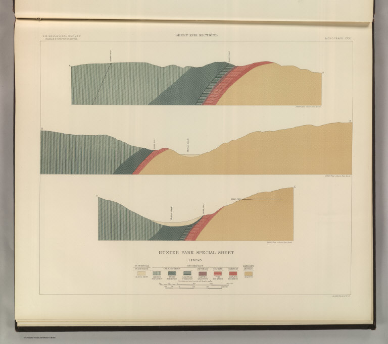
Full Title
Hunter Park Special Sheet. Sheet XVIII Sections. U. S. Geological Survey, Charles D. Walcott, Director. Monograph XXXI. Julius Bien & Co. Lith. N.Y. (1898)
List No
0942.015
Note
Geologic cross-sections shown in color in 8 classes, and faults.
Author
Spurr, Josiah Edward
Full Title
Lenado Special Sheet. Geology Sheet XX . U. S. Geological Survey, Charles D. Walcott, Director. Monograph XXXI. A.H. Thompson, Geographer. F.M Douglas, Topographer in charge. Triangulation by E.M. Douglas. Topography by W.B. Gorse and R.H. Chapman. Surveyed in 1893. S.F. Emmons, Geologist in Charge. Geology by J.E. Spurr. Assistant, G.W. Tower. Julius Bien & Co. Lith. N.Y. (1898)
List No
0942.017
Note
Geology shown in color in 8 classes of rock, and faults. Map and cross sections on one sheet.
Author
Spurr, Josiah Edward
Full Title
Tourtelotte Park Mining District Sheet. Geology Sheet XXI. U. S. Geological Survey, Charles D. Walcott, Director. Monograph XXXI. A.H. Thompson, Geographer. Morris Bien, Topographer in charge. Triangulation by Morris Bien. Topography by F.F. Grove. Surveyed in 1891. S.F. Emmons, Geologist in charge. Geology by J.E. Spurr. Assistant, G.W. Tower. Julius Bien & Co. Lith. N.Y. (1898)
List No
0942.018
Note
Geology shown in color with 10 classes of rock, and faults. Shows alignment of cross-sections on following sheets.
Author
Spurr, Josiah Edward
Full Title
Tourtelotte Park Mining District Sheet. Sheet XXII Sections. U. S. Geological Survey, Charles D. Walcott, Director. Monograph XXXI. Julius Bien & Co. Lith. N.Y. (1898)
List No
0942.019
Note
Geologic cross-sections shown in color in 9 classes, and faults.
Author
Spurr, Josiah Edward
Full Title
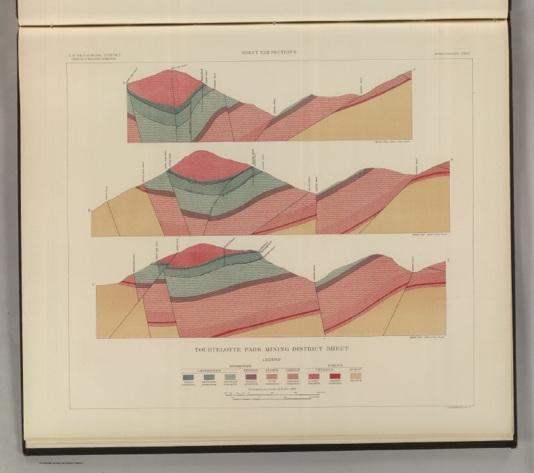
Tourtelotte Park Mining District Sheet. Sheet XXIII Sections. U. S. Geological Survey, Charles D. Walcott, Director. Monograph XXXI. Julius Bien & Co. Lith. N.Y. (1898)
List No
0942.020
Note
Geologic cross-sections shown in color in 9 classes, and faults.
Author
Spurr, Josiah Edward
Full Title
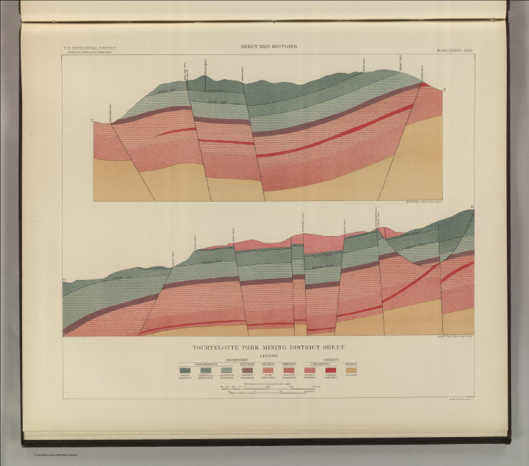
Tourtelotte Park Mining District Sheet. Sheet XXIV Sections. U. S. Geological Survey, Charles D. Walcott, Director. Monograph XXXI. Julius Bien & Co. Lith. N.Y. (1898)
List No
0942.021
Note
Geologic cross-sections shown in color in 9 classes, and faults.
Author
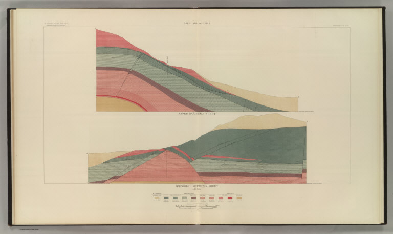
Spurr, Josiah Edward
Full Title
Aspen Mountain Sheet. Geology Sheet XXV. U. S. Geological Survey, Charles D. Walcott, Director. Monograph XXXI. A.H. Thompson, Geographer. Morris Bien, Topographer in charge. Triangulation by Morris Bien. Topography by F.F. Grove. Surveyed in 1891. S.F. Emmons, Geologist in charge. Geology by J.E. Spurr. Assistant, G.W. Tower. Julius Bien & Co. Lith. N.Y. (1898)
List No
0942.022
Note
Geology shown in color with 10 classes of rock, and faults. Shows alignment of cross-sections on following sheet.
Author
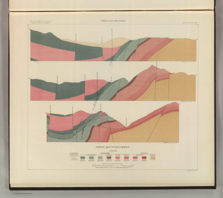
Spurr, Josiah Edward
Full Title
Aspen Mountain Sheet. Sheet XXVI Sections. U. S. Geological Survey, Charles D. Walcott, Director. Monograph XXXI. Julius Bien & Co. Lith. N.Y. (1898)
List No
0942.023
Note
Geologic cross-sections shown in color in 10 classes, and faults.
Author
Spurr, Josiah Edward
Full Title
Smuggler Mountain. Geology Sheet XXVII. U. S. Geological Survey, Charles D. Walcott, Director. Monograph XXXI. A.H. Thompson, Geographer. Morris Bien, Topographer in charge. Triangulation by Morris Bien. Topography by F.F. Grove. Surveyed in 1891. S.F. Emmons, Geologist in charge. Geology by J.E. Spurr. Assistant, G.W. Tower. Julius Bien & Co. Lith. N.Y. (1898)
List No
0942.024
Note
Geology shown in color with 9 classes of rock, and faults. Shows alignment of cross-sections on following sheets.
Author
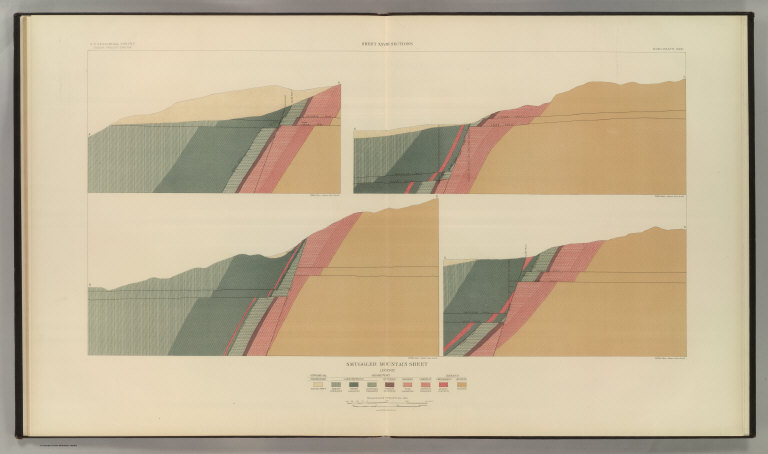
Spurr, Josiah Edward
Full Title
Smuggler Mountain Sheet. Sheet XXVIII Sections. U. S. Geological Survey, Charles D. Walcott, Director. Monograph XXXI. Julius Bien & Co. Lith. N.Y. (1898)
List No
0942.025
Note
Geologic cross-sections shown in color in 9 classes, and faults.
Author
Spurr, Josiah Edward
Full Title
Smuggler Mountain Sheet. Sheet XXIX Sections. U. S. Geological Survey, Charles D. Walcott, Director. Monograph XXXI. Julius Bien & Co. Lith. N.Y. (1898)
List No
0942.026
Note
Geologic cross-sections shown in color in 9 classes, and faults.
Author
Spurr, Josiah Edward
Full Title
Lenado Mining District Sheet. Sheet XXX Sections. U. S. Geological Survey, Charles D. Walcott, Director. Monograph XXXI. Julius Bien & Co. Lith. N.Y. (1898)
List No
0942.027
Note
Geologic map and cross-sections shown in color in 7 classes, and faults.
Author
[Stanford, Edward, Woodward, H.B.]
Full Title
Geological Map of the British Isles by Edward Best. Edward Best, Geological Survey.(in set) Orkney and Shetland Islands.
List No
0949.018
Note
Shows 27 geologic units.
Author
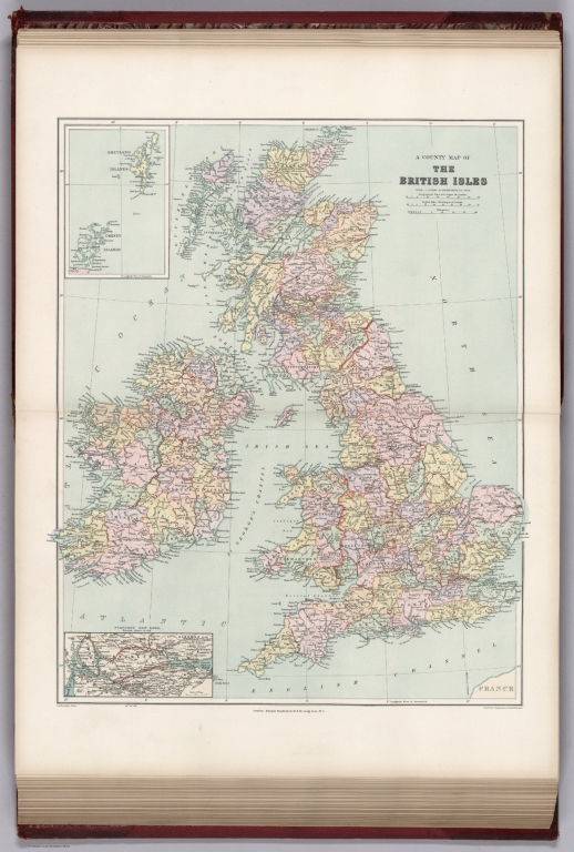
[Stanford, Edward, Woodward, H.B.]
Full Title
A County Map of the British Isles. (inset) Orkney and Shetland Islands.
List No
0949.019
Note
Shows 27 geologic units.
|