|
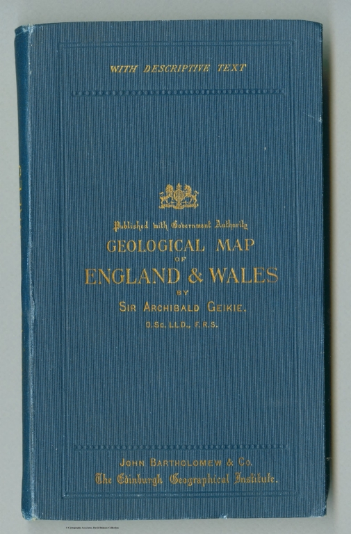
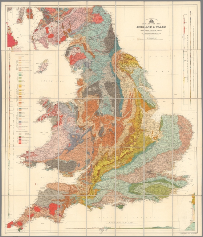
Author
Geikie, Archibald
Full Title
"Geological Map of England and Wales Reduced chiefly from the Ordnance and Geological Surveys under the direction of Sir Archibald Geikie DSc., LLD, FRS, Director General of the Geological Survey. Topography by John Bartholomew F.R.G.S."
List No
15122.001
Author
Geikie, Archibald
Full Title
"Geological Map of England and Wales Reduced chiefly from the Ordnance and Geological Surveys under the direction of Sir Archibald Geikie DSc., LLD, FRS, Director General of the Geological Survey. Topography by John Bartholomew F.R.G.S."
List No
15122.002
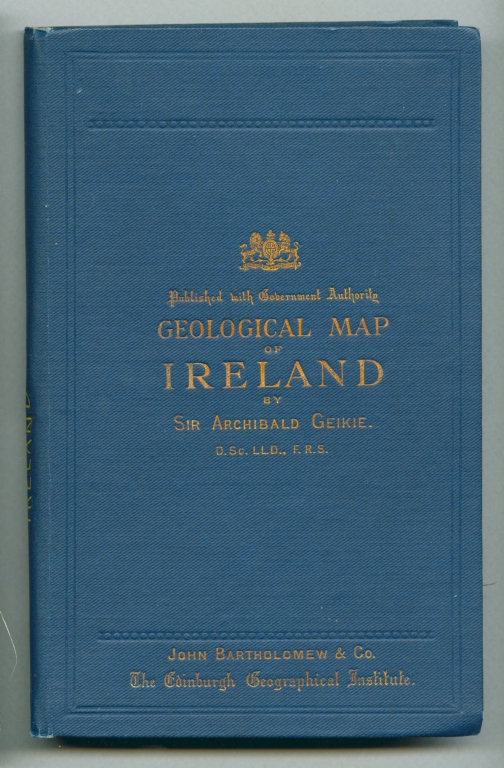
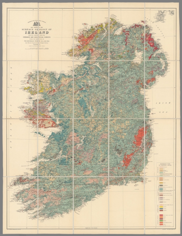
Author
Geikie, Archibald
Full Title
(Covers to) Map Showing the Surface Geology of Ireland. Reduced chiefly from the Ordnance and Geological Surveys under the direction of Sir Archibald Geikie DSc., LLD, FRS, Late Director General of the Geological Survey. Topography by John Bartholomew F.R.G.S."
List No
15123.001
Author
Geikie, Archibald
Full Title
Map Showing the Surface Geology of Ireland. Reduced chiefly from the Ordnance and Geological Surveys under the direction of Sir Archibald Geikie DSc., LLD, FRS, Late Director General of the Geological Survey. Topography by John Bartholomew F.R.G.S."
List No
15123.002
Ravenstein, Ernest George, 1834-1913 Geological Map of England, Wales and the... 1862 15125.002 Related Author
Ravenstein, Ernest George, 1834-1913
Full Title
Geological Map of England, Wales and the Southern part of Scotland drawn from the latest authorities by E G Ravenstein F.R.G.S
List No
15125.002
Note
Date estimated.
Author
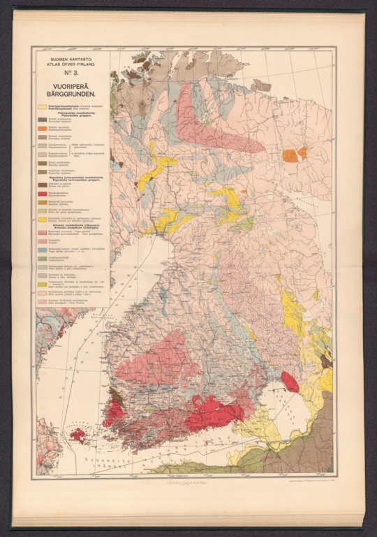
[Suomen Maantieteellinen Seura, Tilgmann, Ferdinand, 1832-1911]
Full Title
No. 3. Vuoriperä. = Bärggrunden. Aktiebolaget F. Tilgmann, Helsingfors 1897.
List No
14366.012
Note
Geologic map of Finland. Features geology in 1897. Also shows political boundaries, cities, railways, bodies of water, drainage, coastlines and islands. Includes latitudinal and longitudinal lines, as well as a legend, bar scale and scale statement given in kilometers. Colored lithograph. Map is 52 x 37 cm, on double sheet 60 x 43 cm. Text presented in parallel Finnish and Swedish.
Englefield, Henry Charles, Sir Bart., 17... Plate 50. Geological map of the Isle of ... 1815 13337.073 Related Author
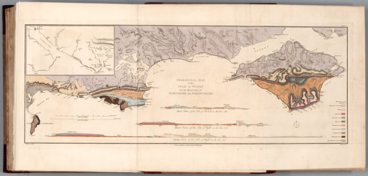
[Englefield, Henry Charles, Sir Bart., 1752-1822, Webster, Thomas]
Full Title
Geological map of the Isle of Wight and the adjacent parts of Hampshire and Dorsetshire. T. Webster delint. J. Walker, Sculpt. London: Published by Payne and Foss. 1815. (to accompany) A description of principal picturesque beauties, antiquities and geological phoenomena of the isle of Wight … 1816.
List No
13337.073
Note
Hand colored geologic folded map, with insets: Southampton to Portsmouth; 3 Geological sections. Included color coded reference to geological formations and compass rose.
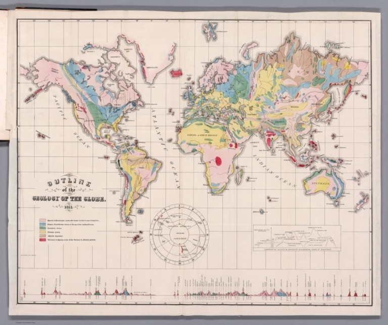
Author
Hitchcock, Edward, 1828-1911
Full Title
Outline of the geology of the globe. 1853. W. C. Sharp's Lith. Boston.
List No
2132.010
Note
Hand-colored, lithographed geologic world map. Shows the major mountain ranges, lakes, drainage and deserts, as well as geological forces and the different strata across the globe, including primary fossiliferous strata, alluvial deposits and volcanoes. Relief shown pictorially. Includes latitudinal and longitudinal lines, as well as a legend. With two inset maps: Supposed Antarctic Continent -- Comparative heights of continents & culminating points of mountains. First inset features Antarctic discoveries, with names of explorers and dates of voyages; second inset compares worldwide mountain elevations. Also, with a profile: [Mountain and volcano heights of the globe]. Map is 47 x 59 cm, on sheet 50 x 61 cm, folded to 20 x 11 cm. First of two maps in Hitchock's Geology of the globe.
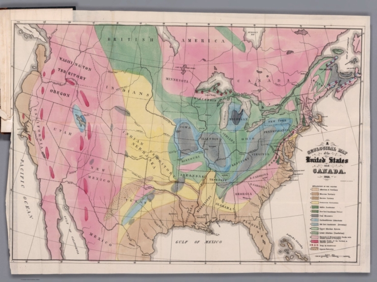
Author
Hitchcock, Edward, 1828-1911
Full Title
A geological map of the United States and Canada. 1853. W. C. Sharp's Lith. Boston.
List No
2132.011
Note
Hand-colored, lithographed geologic map of the United States and Canada. Shows political borders, major mountain ranges, drainage , coastlines and islands, as well as geological strata across the North American continent. Relief shown pictorially. Includes latitudinal and longitudinal lines, as well as a legend and a bar scale. Map is 41 x 61 cm, on sheet 45 x 63 cm, folded to 20 x 11 cm. Second of two maps in Hitchock's Geology of the globe.
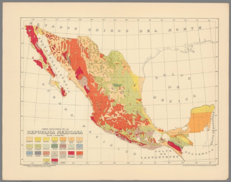
Mexico. Direccion de Estudios Geográfic... Carta geologica de la Republica Mexicana 1921 10559.005 Related Author
Mexico. Direccion de Estudios Geográficos y Climatologicos
Full Title
Carta geologica de la Republica Mexicana. Departamento de Exploraciones y Estudios Geologicos : Secretaria de Industria Comericia y Trabaja. Zincografia de la Direccion de Estadios Geograficos y Climatologicos. ( to accompany) Atlas geografico de la Republica Mexicana 1919-1921.
List No
10559.005
Note
Color map. Includes geological time chart.
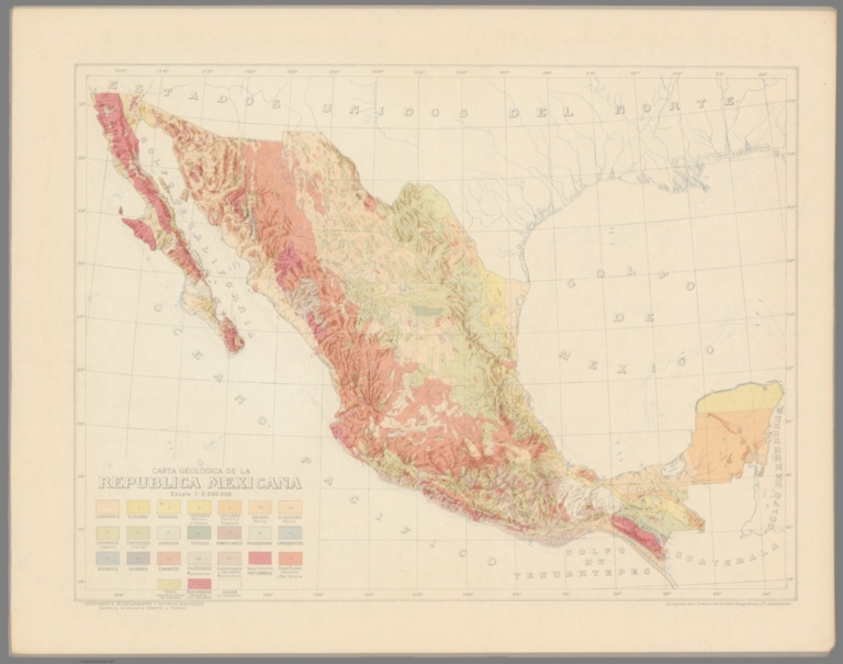
Mexico. Direccion de Estudios Geográfic... Composite: Carta geologica de la Republi... 1921 10559.008 Related Author
Mexico. Direccion de Estudios Geográficos y Climatologicos
Full Title
Composite: Carta geologica de la Republica Mexicana and Relief map overlaid
List No
10559.008
Note
Color map. Includes geological time chart.
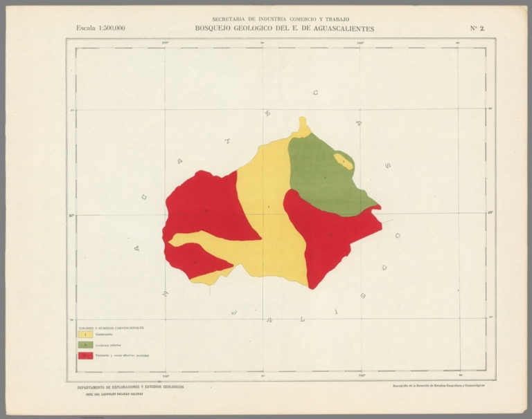
Mexico. Direccion de Estudios Geográfic... No. 2: Bosquejo Geologico Del E. De Agua... 1922 10559.011 Related Author
Mexico. Direccion de Estudios Geográficos y Climatologicos
Full Title
Bosquejo Geologico Del E. De Aguascalientes. Secretaria de Agricultura y Fomento : Direccion de Estadios Geograficos y Climatologicos ... Mexico. 2a. Edicion, 1922. ( to accompany) Atlas geografico de la Republica Mexicana 1919-1921. (on upper margin) No. 2.
List No
10559.011
Note
Geological map.
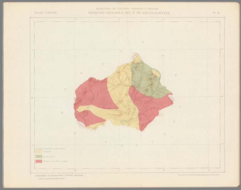
Mexico. Direccion de Estudios Geográfic... Composite: Bosquejo Geologico Del E. De ... 1922 10559.012 Related Author
Mexico. Direccion de Estudios Geográficos y Climatologicos
Full Title
(Composite map of) Bosquejo Geologico Del E. De Aguascalientes and Relief map, Secretaria de Agricultura y Fomento : Direccion de Estadios Geograficos y Climatologicos ... Mexico. 2a. Edicion, 1922. ( to accompany) Atlas geografico de la Republica Mexicana 1919-1921. (on upper margin) No. 2.
List No
10559.012
Note
Geological map and Relief map.
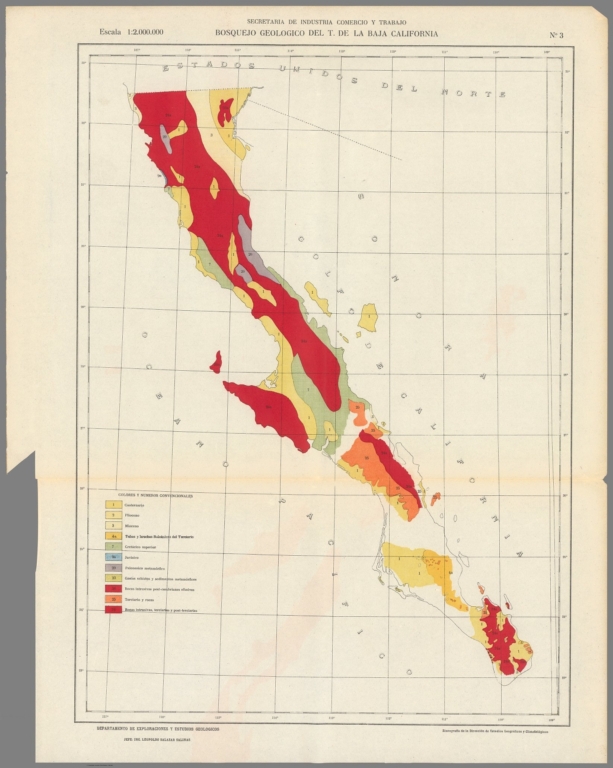
Mexico. Direccion de Estudios Geográfic... No. 3: Bosquejo Geologico Del E. De Baja... 1922 10559.015 Related Author
Mexico. Direccion de Estudios Geográficos y Climatologicos
Full Title
Bosquejo Geologico Del E. De Baja California. Secretaria de Agricultura y Fomento : Direccion de Estadios Geograficos y Climatologicos ... Mexico. 2a. Edicion, 1922. ( to accompany) Atlas geografico de la Republica Mexicana 1919-1921. (on upper margin) No. 2.
List No
10559.015
Note
Geological map.
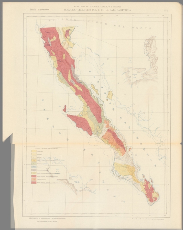
Mexico. Direccion de Estudios Geográfic... Composite: Bosquejo Geologico Del E. De ... 1922 10559.016 Related Author
Mexico. Direccion de Estudios Geográficos y Climatologicos
Full Title
Composite: Bosquejo Geologico Del E. De Baja California and Relief Map Overlaid.
List No
10559.016
Note
Geological map.
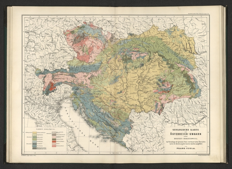
Hölzel, Eduard, 1817-1885; Ed. Hölzel (F... Geologische Karte von Öesterreich-Ungarn... 1887 14348.028 Related Author
[Hölzel, Eduard, 1817-1885, Ed. Hölzel (Firm), Toula, Franz, 1845-1920, Chavanne, Josef, 1846-1902, Toula, Franz, 1845-1920]
Full Title
Geologische Karte von Öesterreich-Ungarn nebst Bosnien-Herzegowina : Auf Grundlage der grossen Franz von Hauer'schen Übersichtskarte mit Benützung der neueren Quellen ausgeführt / von Franz Toula. Ed. Hölzel's geogr. Institut in Wien. Verlag von Ed. Hölzel in Wien.
List No
14348.028
Note
Physical map of Austria-Hungary. Represents the distribution of geology for Austria-Hungary, as well as Bosnia and Herzegovina. Shows political boundaries, cities, railways, valleys, lakes, drainage, coastlines and islands. Includes latitudinal and longitudinal lines, as well as a legend. Colored lithograph. Map is 42 x 57 cm, on double sheet 49 x 65 cm. Descriptive text for Nr. 10 follows map.
Society for the Diffusion of Useful Know... Geological Map of England and Wales. 1872 10911.012 Related Author
Society for the Diffusion of Useful Knowledge (Great Britain)
Full Title
Geological Map of England and Wales.
List No
10911.012
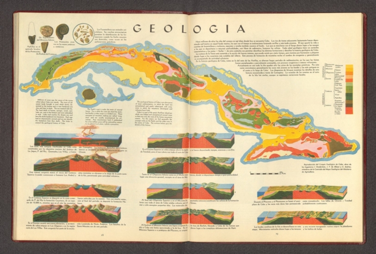
Author
[Canet Alvarez, Gerardo A., 1911-, Raisz, Erwin, 1893-1968, Harvard University. Institute of Geographical Exploration, Cuba. Ministerio de Agricultura]
Full Title
Geologia.
List No
14350.013
Note
Maps showing the geology of Cuba. Title translates to: Geology Features distribution of geological characteristics in the country. With ten cross section views showing the geologic terrain beneath the landscape surface. Includes a legend and illustrations. Accompanied by descriptive text, which appears in Spanish, with English translations.
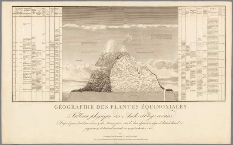
Humboldt, Alexander (1769-1859); Bonplan... Geographie des Plantes Equinoxiales 1805 11083.000 Related Author
[Humboldt, Alexander von, 1769-1859, Bonpland, Aime (1773-1858)]
Full Title
Geographie des Plantes Equinoxiales. Tableau Physique des Andes et Pays voisins, dresse d'apres des observations et des mesures prises sur les lieux depuis le 10(degree) degre de latitude boreale jusquau 10(degree) de latitude australe en 1799, 1800, 1801, 1802 et 1803. Par Alexandre de Humboldt et Aime Bonpland. Esquisse et redige par M. de Humboldt dessine par Schonberger et Turpin a paris en 1805, grave par Bouquet, la lettre par Beauble, imprime par Langlois.
List No
11083.000
Note
Uncolored elevation profile of Equinoctial plants, and geology of Andes Region. Drafted by Humboldt designed by Schonberger and Turpin paris in 1805. Includes 2 tables showing distribution of plants and geology in the area. Shows large number of plant families, genera, and species names corresponding to the vicinity of the equator in America. Relief shown pictorially.
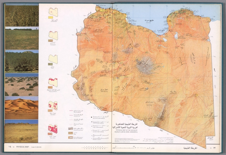
Author
Libya. Maslahat al-Misahah
Full Title
Physical map of the Socialist People's Libyan Arab Jamahiriya. (to accompany) Atlas al-watani lil-Jamahiriyah al-ʻArabiyah al-Libiyah al-Shabiyah al-Ishtirakiyah = National atlas of the Socialist People's Libyan Arab Jamahiriya.
List No
13405.014
Note
Color geological map, in Arabic and English. Shows boundaries, principal cites, roads , tracks, salt marsh, farmlands, deserts, forests and mountains. Includes legend and notes. Relief shown by gradient tints, shading and spot heights. Includes 6 views, with location maps.
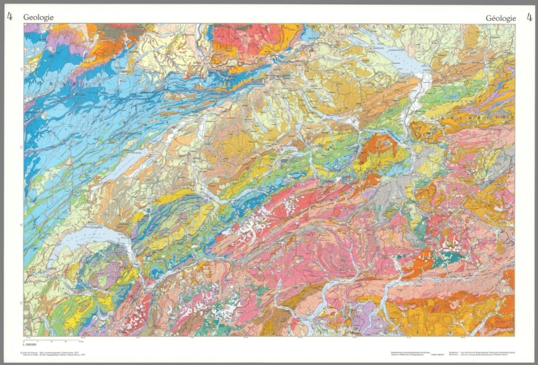
Author
[Imhof, Eduard, 1895-1986, Eidgenössische Landestopographie, Spicher, A. (August), 1914-]
Full Title
Geologie = Géologie. Bearbeitung und kartographische Gestaltung ... : August Spicher. Redaktion ... : Atlas der Schweiz, Eidgenössische Technische Hochschule Zürich ... © Atlas der Schweiz. Eidg. Landestopographie, Wabern-Bern, 1972 ...
List No
14256.034
Note
Colored geological map of Switzerland, numbered 4 within Atlas der Schweiz. On second and third pages of fourth (numbered) folio. Title - in German and French - translates to: [Geology]. Map shows cities and towns, topography, mountains, peak heights, drainage and lakes. Relief shown with contour lines. Includes latitudinal and longitudinal lines, as well as a bar scale and scale statement. Map is 45 x 70 cm, on sheet 52 x 76 cm. "4" in upper left and right corners. Accompanied by descriptive text on first and fourth pages of folio. First folio in a series of two representing the geology of Switzerland (folios 4-4a); subsequent folio contains continued text and a legend associated with map.
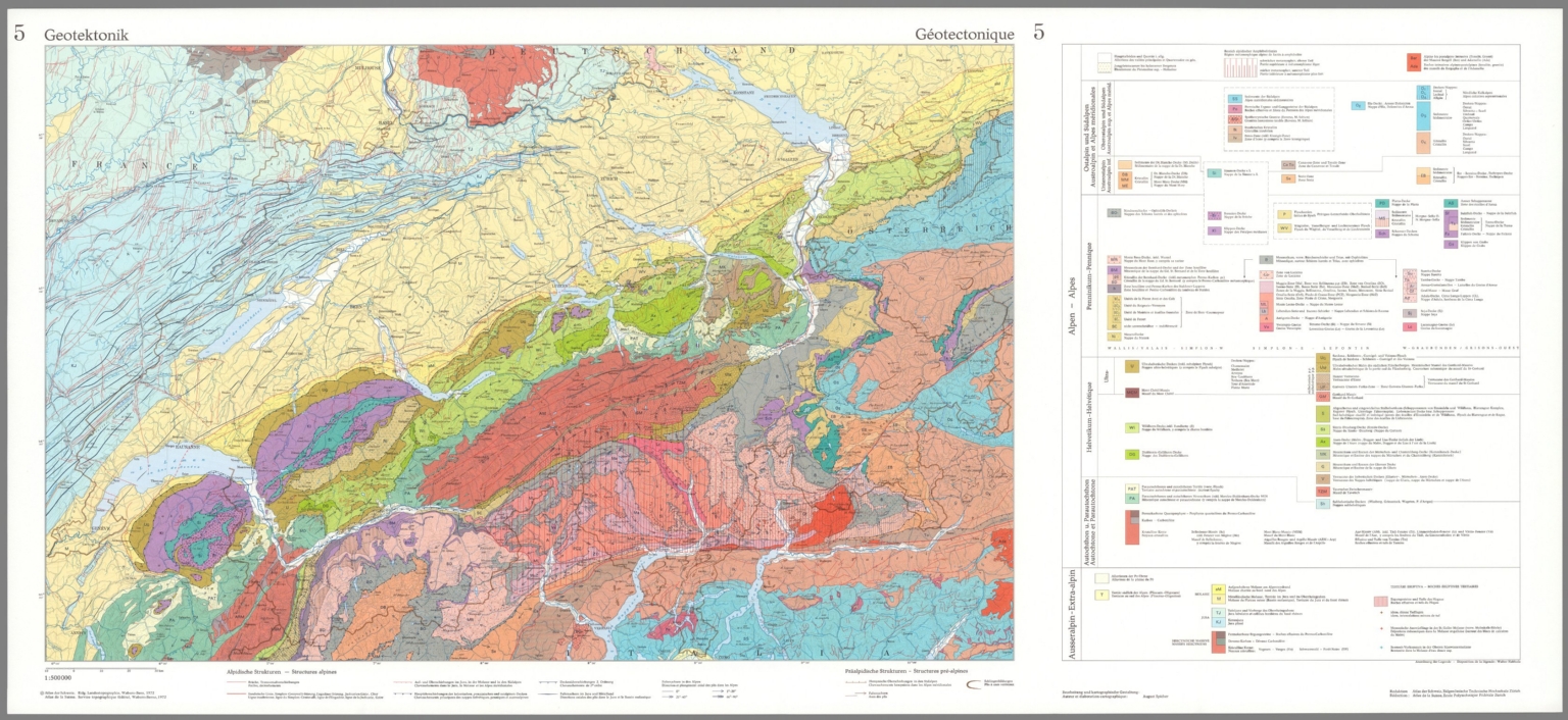
Author
[Imhof, Eduard, 1895-1986, Eidgenössische Landestopographie, Spicher, A. (August), 1914-]
Full Title
Geotektonik = Géotectonique. © Atlas der Schweiz. Eidg. Landestopographie, Wabern-Bern, 1972 ...
List No
14256.040
Note
Colored geological map of Switzerland, numbered 5 within Atlas der Schweiz. On second and third pages of fifth (numbered) folio. Title - in German and French - translates to: [Geotectonics]. Map shows cities and towns, topography, mountains, peak heights, drainage and lakes. Features directions of geotectonic forces with lines and arrows. Relief shown with contour lines. Includes latitudinal and longitudinal lines, as well as a bar scale and scale statement. Map is 45 x 70 cm, on fold-out sheet 51 x 110 cm. Fold-out page Includes legends and explanatory notes. "5" in upper left and center corners. Accompanied by descriptive text on first page of folio, and a profile on fifth and six pages.
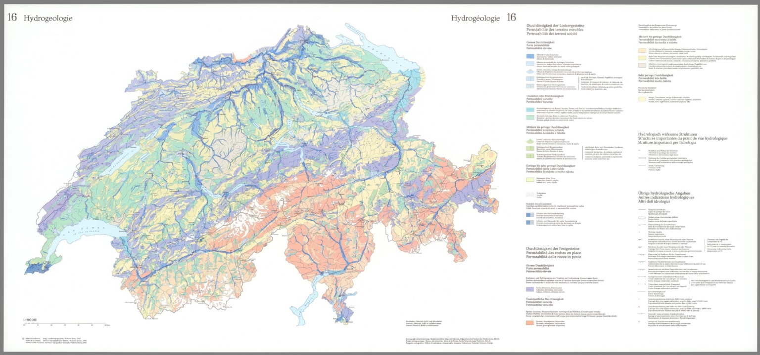
Author
[Imhof, Eduard, 1895-1986, Eidgenössische Landestopographie, Jäckli, H. (Heinrich), Kempf, Th. (Theo), Amberger, G.]
Full Title
Hydrogeologie = Hydrogéolgoie. Bearbeiter: Heinrich Jäckli und Mitarbeiter ... Kartographische Gestaltung: Redaktionsbüro Atlas der Schwiez, Eidgenössischen Technische Hochschule, Zürich ... © Atlas der Schweiz. Eidg. Landestopographie, Wabern-Bern, 1967 ...
List No
14256.076
Note
Colored water map of Switzerland, numbered 16 within Atlas der Schweiz. On second and third pages of sixteenth (numbered) folio. Title - in German and French - translates to: [Hydrogeology]. Map shows the international border, and the distribution and movement of groundwater in the soil and rocks of the Earth's crust. Includes a scale statement. Map is 45 x 70 cm, on fold-out sheet 51 x 110 cm. Fold-out page Includes legends and explanatory notes. "16" in upper left and center corners. Accompanied by descriptive text on first and fifth pages of folio.
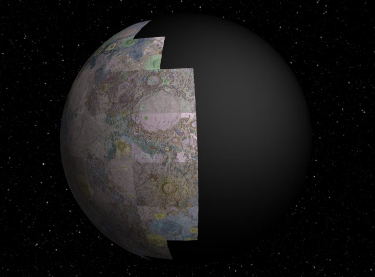
Author
U.S. Geological Survey
Full Title
(Interactive Globe) Sheets 1-44 of the Geologic Atlas of the Moon.
List No
12101.089
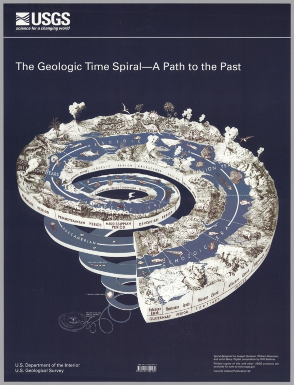
U.S. Geological Survey; Graham, Joseph; ... The Geologic Time Spiral-A Path to the P... 2008 10627.000 Related Author
[U.S. Geological Survey, Graham, Joseph, Newman, William, Stacy, John]
Full Title
The Geologic Time Spiral-A Path to the Past. General Interest Publication 58.
List No
10627.000
Author
[Knipe, James Alexander , Walker, John, Walker, Charles]
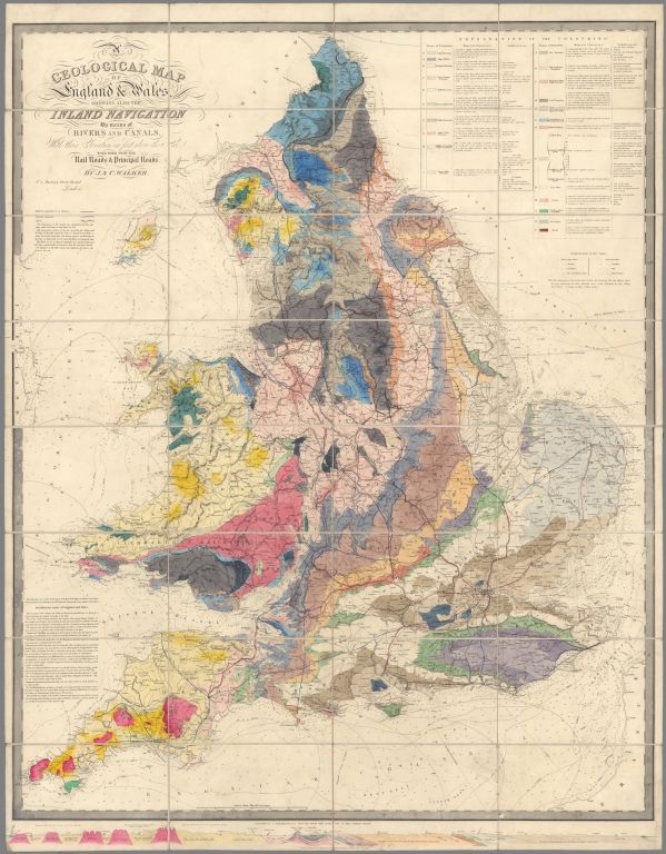
Full Title
Geological Map of England and Wales showing also the Inland navigation by means of Rivers and Canals with their elevation in feet above the sea together with the Rail Roads & Principal Roads by J & C Walker.
List No
10535.002
Note
Map shows mineral types occurring across England, Wales, and southern and central Scotland. Relief shown by hachures. Includes geological and mineralogical sections from Lands End and from the St. George's Channel to the German Ocean.
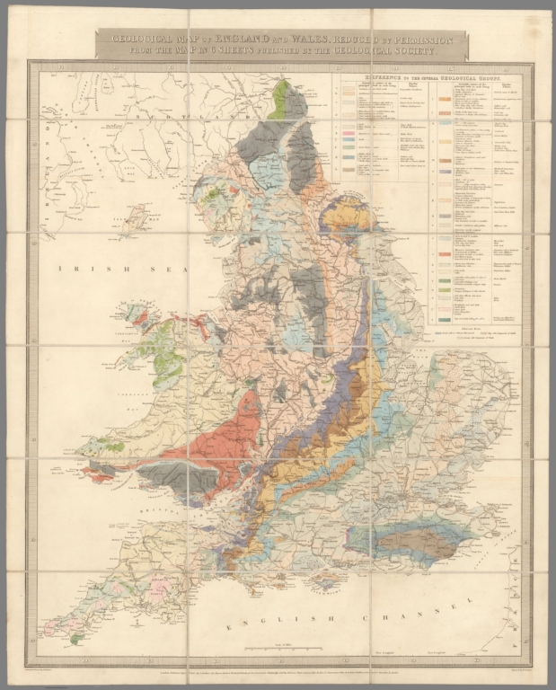
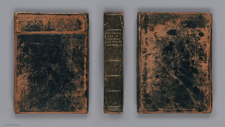
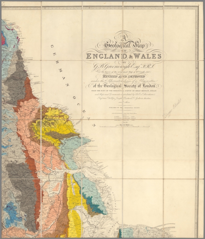
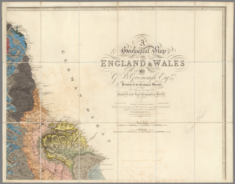
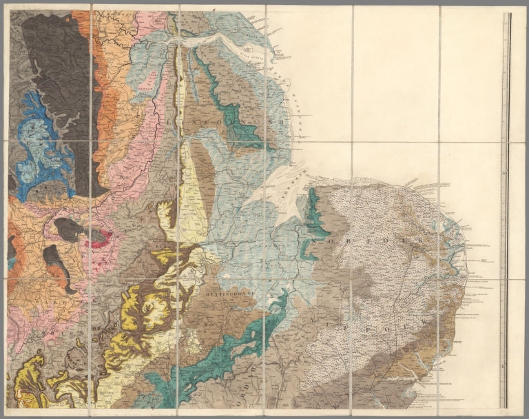
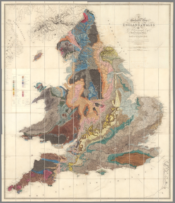
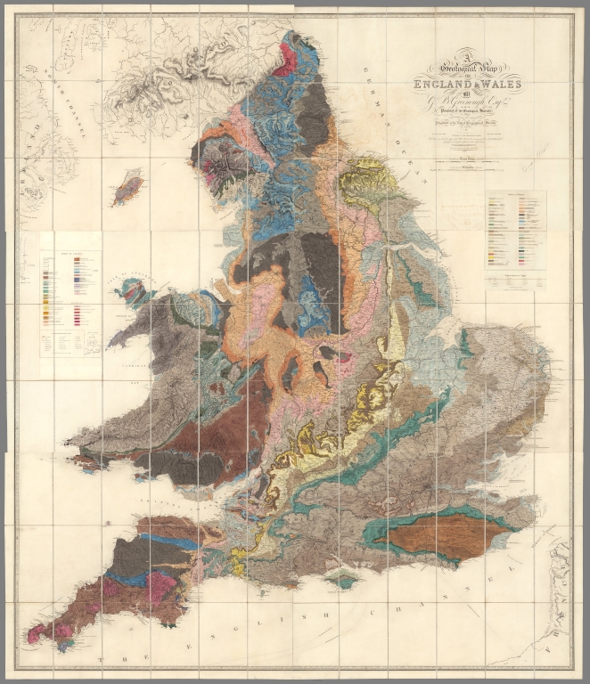
Author
Greenough, George Bellas, (1778-1855)
Full Title
A Geological Map of England and Wales reduced by permission from the map in 6 sheets published by the Geological Society.
List No
10516.002
Note
Reduced from the first edition of Greenough's important large six sheet map published in 1819 in response to William Smith's pioneering Geological map of England and Wales published in 1815. See our copies of the Greenough 1839 second edition (10496.000) and the 1865 final thrid edition (10491.000).
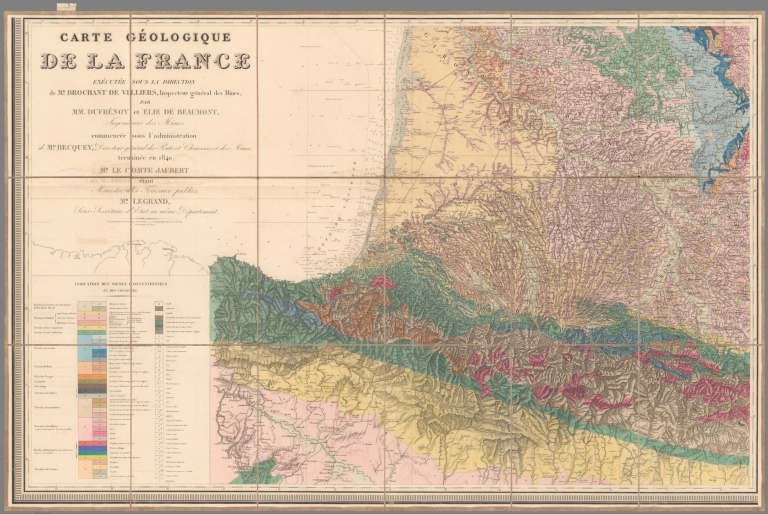
Brochant de Villiers, Andre Jean Marie; ... Sheet 5. Carte Géologique de la France. 1840 10514.010 Related Author
[Brochant de Villiers, Andre Jean Marie, Dufrénoy, A. (Armand), 1792-1857., Élie de Beaumont, Léonce, 1798-1874.]
Full Title
Sheet 5. Carte Géologique de la France. Exécutée sous la direction de Mr. Brochant de Villiers, Inspecteur général des mines, par Mm. Dufrénoy et Elie de Beaumont, ingénieurs des mines. Le dessin du relief a été exécutée par A. Desmadryl. La topographie gravée par C. E. Collin, la lettre par J. M. Hacq.
List No
10514.010
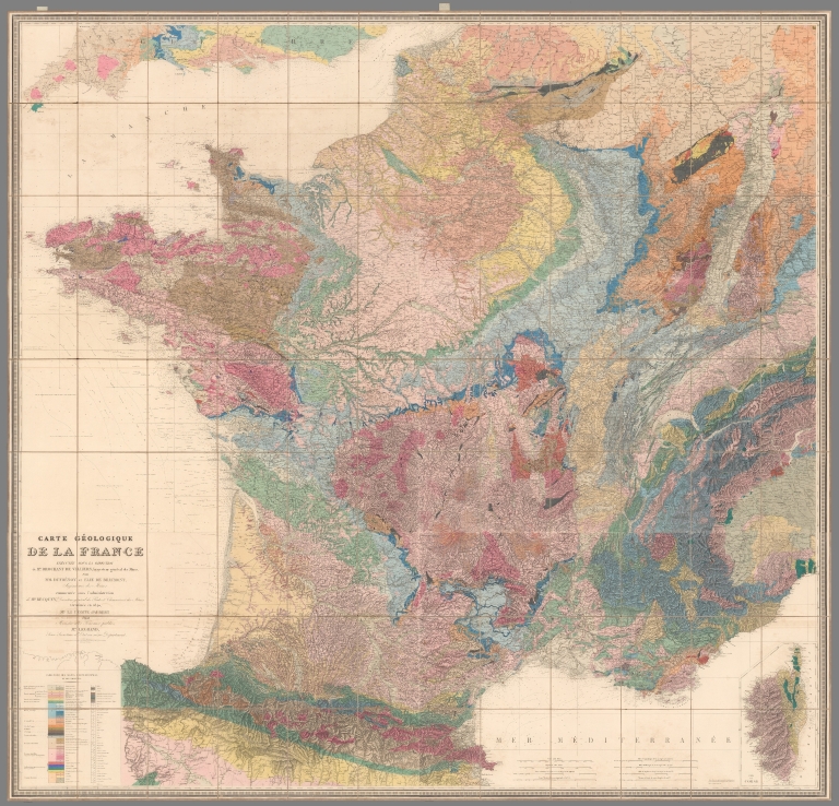
Brochant de Villiers, Andre Jean Marie; ... Composite: Sheets 1- 6. Carte Géologique... 1840 10514.013 Related Author
[Brochant de Villiers, Andre Jean Marie, Dufrénoy, A. (Armand), 1792-1857., Élie de Beaumont, Léonce, 1798-1874.]
Full Title
(Composite map of) Sheets 1- 6. Carte Géologique de la France. Exécutée sous la direction de Mr. Brochant de Villiers, Inspecteur général des mines, par Mm. Dufrénoy et Elie de Beaumont, ingénieurs des mines. Le dessin du relief a été exécutée par A. Desmadryl. La topographie gravée par C. E. Collin, la lettre par J. M. Hacq.
List No
10514.013
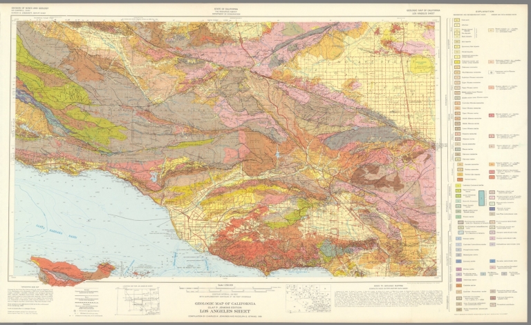
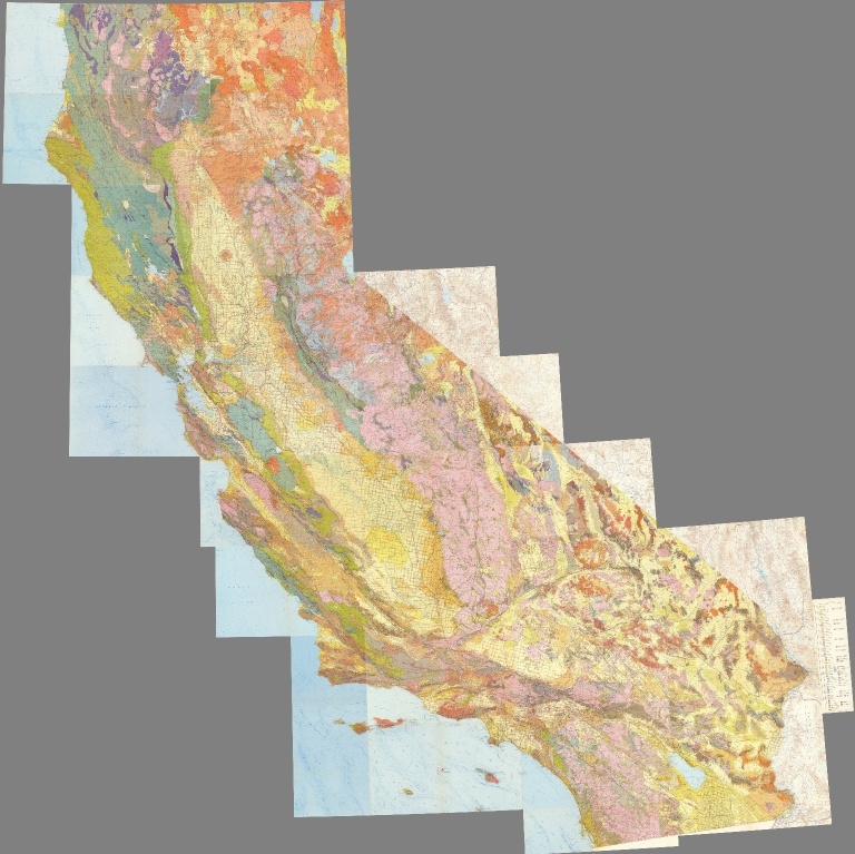
California Division of Mines and Geology Geologic Map of California, Los Angeles ... 1969 6347.037 Related Author
California Division of Mines and Geology
Full Title
Geologic Map of California, Los Angeles Sheet.
List No
6347.037
Note
Full color. Olaf P. Jenkins Edition.
California Division of Mines and Geology Composite Map: Geologic Map of Californi... 1969 6347.114 Related Author
California Division of Mines and Geology
Full Title
(Composite Map) Geologic Map of California.
List No
6347.114
Note
Full color. Olaf P. Jenkins Edition. Individual sheets dated 1958-1969.
Greenough, George Bellas, (1778-1855) Covers: A Physical and Geological Map of... 1865 10491.001 Related Author
Greenough, George Bellas, (1778-1855)
Full Title
(Covers to) A Physical and Geological Map of England and Wales By G.B. Greenough Esq. F.R.S. (on the basis of the original Map of William Smith 1815) Revised and Improved under the Superintendence of a Committee of the Geological Society of London, from the maps of the Geological Survey of Great Britain, 1836-63 and the Maps and Documents contributed by Sir R. I. Murchison, Professor Phillips, Joseph Prestwich, R. Godwin Austen, and others. July 1865.
List No
10491.001
Note
Greenough first published this map in 1820, then a second edition in 1839 (see our 10496.000), and this final third posthumous edition in 1865. Greenough drew heavily on William Smith's Geological map of England and Wales but did not credit him until the third edition. There are several differences between the Greenough and Smith maps: Greenough delineates the topography and Smith does not, and Greenough's scale is 6 miles to the inch vs Smith at 5 miles to the inch. There were also differences underlying the geology of both maps. Greenough made significant revisions to the second edition and to this final third edition. Following the publication of the first 1820 edition, there was a continuing dispute between Greenough and Smith as to Greenough's uncredited use of Smith's map.
Greenough, George Bellas, (1778-1855) N.E. Sheet. A Physical and Geological Ma... 1865 10491.002 Related Author
Greenough, George Bellas, (1778-1855)
Full Title
N.E. Sheet. A Physical and Geological Map of England and Wales By G.B. Greenough Esq. F.R.S. (on the basis of the original Map of William Smith 1815) Revised and Improved under the Superintendence of a Committee of the Geological Society of London, from the maps of the Geological Survey of Great Britain, 1836-63 and the Maps and Documents contributed by Sir R. I. Murchison, Professor Phillips, Joseph Prestwich, R. Godwin Austen, and others. July 1865.
List No
10491.002
Note
Greenough first published this map in 1820, then a second edition in 1839 (see our 10496.000), and this final third posthumous edition in 1865. Greenough drew heavily on William Smith's Geological map of England and Wales but did not credit him until the third edition. There are several differences between the Greenough and Smith maps: Greenough delineates the topography and Smith does not, and Greenough's scale is 6 miles to the inch vs Smith at 5 miles to the inch. There were also differences underlying the geology of both maps. Greenough made significant revisions to the second edition and to this final third edition. Following the publication of the first 1820 edition, there was a continuing dispute between Greenough and Smith as to Greenough's uncredited use of Smith's map.
Greenough, George Bellas, (1778-1855) S.E. Sheet. A Physical and Geological Ma... 1865 10491.005 Related Author
Greenough, George Bellas, (1778-1855)
Full Title
S.E. Sheet. A Physical and Geological Map of England and Wales By G.B. Greenough Esq. F.R.S. (on the basis of the original Map of William Smith 1815) Revised and Improved under the Superintendence of a Committee of the Geological Society of London, from the maps of the Geological Survey of Great Britain, 1836-63 and the Maps and Documents contributed by Sir R. I. Murchison, Professor Phillips, Joseph Prestwich, R. Godwin Austen, and others. July 1865.
List No
10491.005
Note
Greenough first published this map in 1820, then a second edition in 1839 (see our 10496.000), and this final third posthumous edition in 1865. Greenough drew heavily on William Smith's Geological map of England and Wales but did not credit him until the third edition. There are several differences between the Greenough and Smith maps: Greenough delineates the topography and Smith does not, and Greenough's scale is 6 miles to the inch vs Smith at 5 miles to the inch. There were also differences underlying the geology of both maps. Greenough made significant revisions to the second edition and to this final third edition. Following the publication of the first 1820 edition, there was a continuing dispute between Greenough and Smith as to Greenough's uncredited use of Smith's map.
Greenough, George Bellas, (1778-1855) Composite: N.E.,N.W.,S.W.,S.E. Sheets. A... 1865 10491.006 Related Author
Greenough, George Bellas, (1778-1855)
Full Title
(Composite map of) N.E.,N.W.,S.W.,S.E. Sheets. A Physical and Geological Map of England and Wales By G.B. Greenough Esq. F.R.S. (on the basis of the original Map of William Smith 1815) Revised and Improved under the Superintendence of a Committee of the Geological Society of London, from the maps of the Geological Survey of Great Britain, 1836-63 and the Maps and Documents contributed by Sir R. I. Murchison, Professor Phillips, Joseph Prestwich, R. Godwin Austen, and others. July 1865.
List No
10491.006
Note
Greenough first published this map in 1820, then a second edition in 1839 (see our 10496.000), and this final third posthumous edition in 1865. Greenough drew heavily on William Smith's Geological map of England and Wales but did not credit him until the third edition. There are several differences between the Greenough and Smith maps: Greenough delineates the topography and Smith does not, and Greenough's scale is 6 miles to the inch vs Smith at 5 miles to the inch. There were also differences underlying the geology of both maps. Greenough made significant revisions to the second edition and to this final third edition. Following the publication of the first 1820 edition, there was a continuing dispute between Greenough and Smith as to Greenough's uncredited use of Smith's map.
Greenough, George Bellas, (1778-1855) Covers: A Physical and Geological Map of... 1839 10496.001 Related Author
Greenough, George Bellas, (1778-1855)
Full Title
(Covers to) A Physical and Geological Map of England and Wales By G.B. Greenough Esq. President of the Geological Society of London. At its Establishment and at subsequent periods: President of the Royal Geographical Society of London &c. First Edition No. 1st 1819. Second Edition Novr. 1st 1839.
List No
10496.001
Note
Greenough first published this map in 1820, then this second edition in 1839, and a final third posthumous edition in 1865. Greenough drew heavily on William Smith's Geological map of England and Wales but did not credit him until the third edition. There are several differences between the Greenough and Smith maps: Greenough delineates the topography and Smith does not, and Greenough's scale is 6 miles to the inch vs Smith at 5 miles to the inch. There were also differences underlying the geology of both maps. Greenough made significant revisions to this second edition and to the final third edition. Following the publication of the first 1820 edition, there was a continuing dispute between Greenough and Smith as to Greenough's uncredited use of Smith's map. The N.E. sheet is from a different copy as is the Index of Colours which was both pasted on the map in some copies and issued separately in others - both are present here. Although it appears that the index of colors that is pasted onto the W. Sheet of this copy is an early version of the index of colors that appears on the 1865 third edition. It does not actually represent the colors used on the map so may have been added afterwards, incorrectly. The separate sheet Index of Colours is the correct index for colors in this second edition.
Greenough, George Bellas, (1778-1855) N.E. Sheet. A Physical and Geological Ma... 1839 10496.002 Related Author
Greenough, George Bellas, (1778-1855)
Full Title
N.E. Sheet. A Physical and Geological Map of England and Wales By G.B. Greenough Esq. President of the Geological Society of London. At its Establishment and at subsequent periods: President of the Royal Geographical Society of London &c. First Edition No. 1st 1819. Second Edition Novr. 1st 1839.
List No
10496.002
Note
Greenough first published this map in 1820, then this second edition in 1839, and a final third posthumous edition in 1865. Greenough drew heavily on William Smith's Geological map of England and Wales but did not credit him until the third edition. There are several differences between the Greenough and Smith maps: Greenough delineates the topography and Smith does not, and Greenough's scale is 6 miles to the inch vs Smith at 5 miles to the inch. There were also differences underlying the geology of both maps. Greenough made significant revisions to this second edition and to the final third edition. Following the publication of the first 1820 edition, there was a continuing dispute between Greenough and Smith as to Greenough's uncredited use of Smith's map. The N.E. sheet is from a different copy as is the Index of Colours which was both pasted on the map in some copies and issued separately in others - both are present here. Although it appears that the index of colors that is pasted onto the W. Sheet of this copy is an early version of the index of colors that appears on the 1865 third edition. It does not actually represent the colors used on the map so may have been added afterwards, incorrectly. The separate sheet Index of Colours is the correct index for colors in this second edition.
Greenough, George Bellas, (1778-1855) E. Sheet. A Physical and Geological Map ... 1839 10496.004 Related Author
Greenough, George Bellas, (1778-1855)
Full Title
E. Sheet. A Physical and Geological Map of England and Wales By G.B. Greenough Esq. President of the Geological Society of London. At its Establishment and at subsequent periods: President of the Royal Geographical Society of London &c. First Edition No. 1st 1819. Second Edition Novr. 1st 1839.
List No
10496.004
Note
Greenough first published this map in 1820, then this second edition in 1839, and a final third posthumous edition in 1865. Greenough drew heavily on William Smith's Geological map of England and Wales but did not credit him until the third edition. There are several differences between the Greenough and Smith maps: Greenough delineates the topography and Smith does not, and Greenough's scale is 6 miles to the inch vs Smith at 5 miles to the inch. There were also differences underlying the geology of both maps. Greenough made significant revisions to this second edition and to the final third edition. Following the publication of the first 1820 edition, there was a continuing dispute between Greenough and Smith as to Greenough's uncredited use of Smith's map. The N.E. sheet is from a different copy as is the Index of Colours which was both pasted on the map in some copies and issued separately in others - both are present here. Although it appears that the index of colors that is pasted onto the W. Sheet of this copy is an early version of the index of colors that appears on the 1865 third edition. It does not actually represent the colors used on the map so may have been added afterwards, incorrectly. The separate sheet Index of Colours is the correct index for colors in this second edition.
Greenough, George Bellas, (1778-1855) Composite: A Physical and Geological Map... 1839 10496.009 Related Author
Greenough, George Bellas, (1778-1855)
Full Title
(Composite map of) A Physical and Geological Map of England and Wales By G.B. Greenough Esq. President of the Geological Society of London. At its Establishment and at subsequent periods: President of the Royal Geographical Society of London &c. First Edition No. 1st 1819. Second Edition Novr. 1st 1839.
List No
10496.009
Note
Greenough first published this map in 1820, then this second edition in 1839, and a final third posthumous edition in 1865. Greenough drew heavily on William Smith's Geological map of England and Wales but did not credit him until the third edition. There are several differences between the Greenough and Smith maps: Greenough delineates the topography and Smith does not, and Greenough's scale is 6 miles to the inch vs Smith at 5 miles to the inch. There were also differences underlying the geology of both maps. Greenough made significant revisions to this second edition and to the final third edition. Following the publication of the first 1820 edition, there was a continuing dispute between Greenough and Smith as to Greenough's uncredited use of Smith's map. The N.E. sheet is from a different copy as is the Index of Colours which was both pasted on the map in some copies and issued separately in others - both are present here. Although it appears that the index of colors that is pasted onto the W. Sheet of this copy is an early version of the index of colors that appears on the 1865 third edition. It does not actually represent the colors used on the map so may have been added afterwards, incorrectly. The separate sheet Index of Colours is the correct index for colors in this second edition.
Greenough, George Bellas, (1778-1855) Composite: A Physical and Geological Map... 1839 10496.010 Related Author
Greenough, George Bellas, (1778-1855)
Full Title
(Composite map of) A Physical and Geological Map of England and Wales By G.B. Greenough Esq. President of the Geological Society of London. At its Establishment and at subsequent periods: President of the Royal Geographical Society of London &c. First Edition No. 1st 1819. Second Edition Novr. 1st 1839.
List No
10496.010
Note
Note: This composite image has added the original separately printed Index of Colours below the title on the E. Sheet. Greenough first published this map in 1820, then this second edition in 1839, and a final third posthumous edition in 1865. Greenough drew heavily on William Smith's Geological map of England and Wales but did not credit him until the third edition. There are several differences between the Greenough and Smith maps: Greenough delineates the topography and Smith does not, and Greenough's scale is 6 miles to the inch vs Smith at 5 miles to the inch. There were also differences underlying the geology of both maps. Greenough made significant revisions to this second edition and to the final third edition. Following the publication of the first 1820 edition, there was a continuing dispute between Greenough and Smith as to Greenough's uncredited use of Smith's map. The N.E. sheet is from a different copy as is the Index of Colours which was both pasted on the map in some copies and issued separately in others - both are present here. Although it appears that the index of colors that is pasted onto the W. Sheet of this copy is an early version of the index of colors that appears on the 1865 third edition. It does not actually represent the colors used on the map so may have been added afterwards, incorrectly. The separate sheet Index of Colours is the correct index for colors in this second edition.
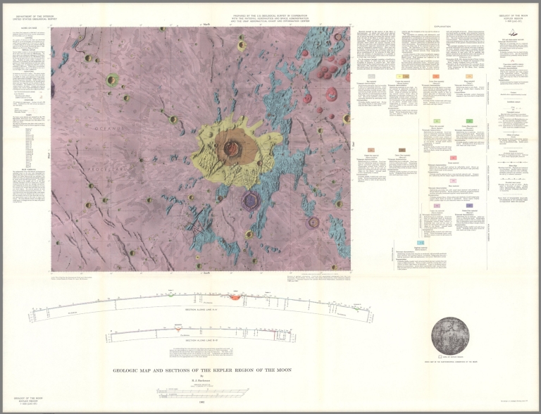
Hackman, R.J.; U.S. Geological Survey Geologic Map and Sections of the Kepler ... 1962 12101.002 Related Author
[Hackman, R.J., U.S. Geological Survey]
Full Title
Geologic Map and Sections of the Kepler Region of the Moon. MAP I - 355 (LAC-57).
List No
12101.002
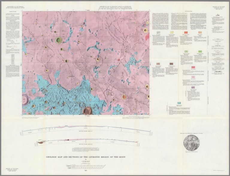
Marshall, C.H.; U.S. Geological Survey Geologic Map and Sections of the Letronn... 1963 12101.004 Related Author
[Marshall, C.H., U.S. Geological Survey]
Full Title
Geologic Map and Sections of the Letronne Region of the Moon. MAP I - 385 (LAC-75).
List No
12101.004
Author
U.S. Geological Survey
Full Title
Index Map of the Earthside Hemisphere of the Moon.
List No
12101.086
Note
Shows the relative positions of the 44 sheets that make up the Geologic Atlas of the Moon. Taken from the Macrobius sheet.
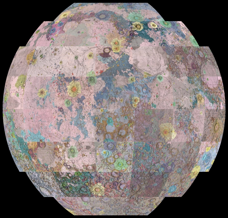
Author
U.S. Geological Survey
Full Title
(Composite map of) Sheets 1-44 of the Geologic Atlas of the Moon.
List No
12101.087
Note
Orthographic Projection.
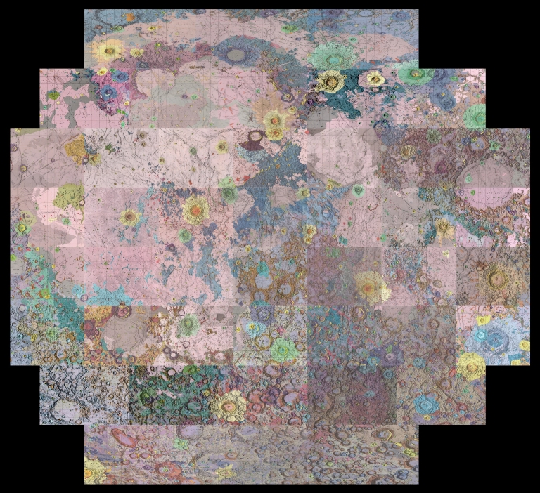
Author
U.S. Geological Survey
Full Title
(Composite map of) Sheets 1-44 of the Geologic Atlas of the Moon.
List No
12101.088
Note
Geographic projection (unprojected)
Author
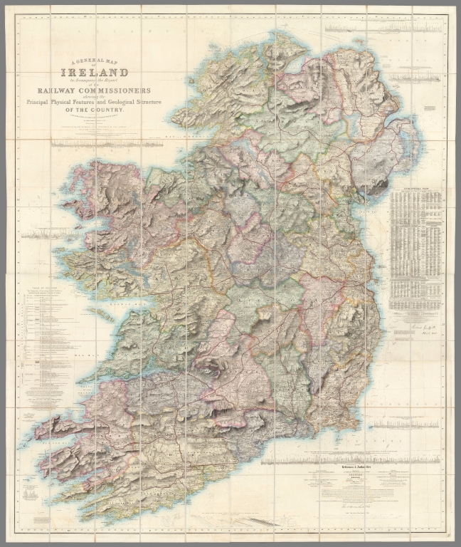
[Ireland, Railway Commissioners, Griffith, Richard John,; Sir; (1784-1878)]
Full Title
(Composite map of) A General Map Of Ireland to Accompany the Report of the Railway Commissioners shewing the Principal Physical Features and Geological Structure Of The Country. Constructed In 1836 And Engraved In 1837-8. The Geology Revised And Improved In 1855. Published And Sold By Hodges & Smith, Dublin, And Longman & Co., London. With whom Copies coloured Geologically are deposited. Price Twenty Shillings Plain ...
List No
0337.006
Note
1st ed. was 1836/7; Signed by Griffith & Larcom (perhaps printed signatures). Not colored Geologically, but politically with the Railroads. Originally published to accompany the Atlas to accompany the second Report of the Railway Commissioners, 1837. Map is in four sheets, each dissected into 20 sections. Full color. Sheets have marbled end papers and fold into a black leather covered slip case 25x18 with "Map Of Ireland. Stanford" stamped in gilt on the spine.
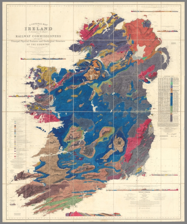
Ireland, Railway Commissioners; Griffith... Composite: Sheets 1-6. A General Map Of ... 1855 10485.007 Related Author
[Ireland, Railway Commissioners, Griffith, Richard John,; Sir; (1784-1878)]
Full Title
Composite map of) Sheets 1-6. A General Map Of Ireland to Accompany the Report of the Railway Commissioners shewing the Principal Physical Features and Geological Structure Of The Country. Constructed In 1836 And Engraved In 1837-8. The Geology Revised And Improved In 1855. Published And Sold By Hodges & Smith, Dublin, And Longman & Co., London. With whom Copies coloured Geologically are deposited. Price Twenty Shillings Plain ...(Geologically colored).
List No
10485.007
Note
1st ed. was 1836/7; Signed by Griffith & Larcom (perhaps printed signatures). Colored Geologically, showing political boundaries and railroads. Originally published to accompany the Atlas to accompany the second Report of the Railway Commissioners, 1837. Map is in six sheets, each dissected into 8 sections. Full color. Sheets have marbled end papers.
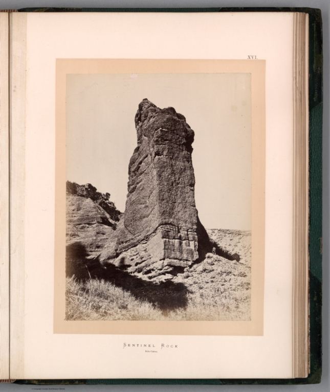
Author
[Hayden, Ferdinand Vandeveer, 1829-1887, Russell, Andrew Joseph, 1830-1902]
Full Title
Sentinel Rock - Echo Canon. (to accompany) Sun pictures of Rocky Mountain scenery ... by F. V. Hayden, ... New York : Julius Bien, 1870.
List No
13389.020
Note
Black and white view, shows rock formations in Echo Canon, Utah.
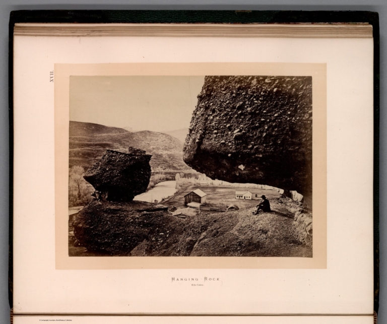
Author
[Hayden, Ferdinand Vandeveer, 1829-1887, Russell, Andrew Joseph, 1830-1902]
Full Title
Hanging Rock : Echo Canon. (to accompany) Sun pictures of Rocky Mountain scenery ... by F. V. Hayden, ... New York : Julius Bien, 1870.
List No
13389.021
Note
Black and white view, shows rock formations and settlements in Echo Canon, Utah.
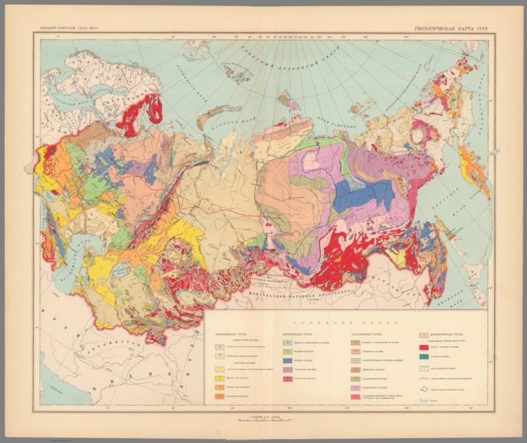
Author
[Gorkin, Aleksandr Fedorovich, Motylev, V.E.]
Full Title
Geologicheskaia karta SSSR. (to accompany) Bolshoi Sovietskii Atlas Mira. Moskva 1937.
List No
11008.105
Note
Color maps on 2 sheets. Showing geological formations in Soviet Union. Includes explanation and color coded reference.
|