|
Author
[McInnes, William, Dowling, D.B., Leach, W.W.]
Full Title
(Title Page Verso to) Copyright, 1913, By Morang & Co., Limited, Toronto, Canada. Murray Printing Co. Limited, Toronto, Canada.
List No
2249.003
Author
[McInnes, William, Dowling, D.B., Leach, W.W.]
Full Title
(Table of Contents to) The Coal Resources Of The World. Atlas. Edited By William McInnes, B.S., F.R.S.C.; D.B. Dowling, B.A.Sc., F.R.S.C., And W.W. Leach, B.A.Sc.; Of The Geological Survey Of Canada. Morang & Co., Limited, Publishers: Toronto, Canada. (seal) Geologorum Conventus Mente Et Malleo. XII 1913 Canada. (on verso) Copyright, 1913, By Morang & Co., Limited, Toronto, Canada. Murray Printing Co. Limited, Toronto, Canada.
List No
2249.004
Author
[McInnes, William, Dowling, D.B., Leach, W.W.]
Full Title
Coal Resources of the World. Hemispheres. Map No. 1. Western Hemisphere. Eastern Hemisphere.
List No
2249.005
Note
Differentiates Tertiary, Mesozoic, and Paleozoic coal fields by color.
Author
Pittman, E.F.
Full Title
Coal Resources of the World. New South Wales, Australia. Map No. 2. Map of New South Wales Showing the Areas Occupied by the Coal Measures. E.F. Pittman, A.R.S.M., Government Geologist.
List No
2249.006
Note
Coal fields labeled in red.
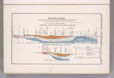
Author
[Pittman, E.F., David, T.W.E.]
Full Title
Coal Resources of the World. New South Wales, Australia. Map No. 3. Geological Sections Showing the Structure of the Main Coal Basin of New South Wales Compiled Chiefly from Surveys by Professor T.W.E. David, C.M.G., B.A., F.R.S., F.G.S. E.F. Pittman, A.R.S.M., Government Geologist. Longitudinal Section from the Clyde River to Singleton. Transverse Section from Rydal to the Coast.
List No
2249.007
Author
Dunstan, B.
Full Title
Coal Resources of the World. Queensland, Australia. Map No. 4. Queensland Showing Principal Coal Areas. B. Dunstan, F.G.S. Government Geologist.
List No
2249.008
Note
Shows railroads.
Author
Woodward, H.P.
Full Title
Coal Resources of the World. West Australia. Map No. 5. Collie Coalfield with Amended Boundaries of the Collie Coal Measure Basin by H.P. Woodward. Assistant Government Geologist.
List No
2249.009
Note
Covers Collie Coal Mining District. Shows locations of longitudinal sections shown on 2249.010.
Full Title
Coal Resources of the World. West Australia. Map No. 6. Collie Coalfield Longitudinal Section.
List No
2249.010
Note
See 2249.009 for location of cross-section.
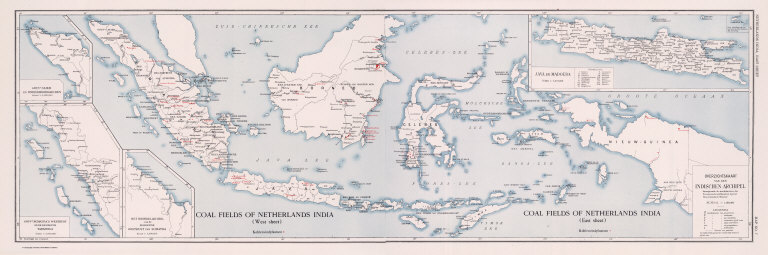
Full Title
Coal Resources of the World. Coal Fields of Netherlands India. (West Sheet) (East Sheet) Overzichtskaart van den Indischen Archipel. Map No. 7.
List No
2249.011
Note
In Dutch.
Full Title
(Composite) Coal Fields of Netherlands India. Overzichtskaart van den Indischen Archipel. Coal Resources of the World. (inset) Gouvt. Atjeh en Onderhoorigheden. (inset) Gouvt. Sumatra's Westkust en de Residentie Tapanoeli. (inset) Het Noordelijk Deel van de Residentie Oostkust van Sumatra. (inset) Java en Madoera.
List No
2249.012
Full Title
Coal Resources of the World. Netherlands India. Map No. 8. Oversichtskaart van het Ombilin Kolenveld.
List No
2249.013
Note
In Dutch.
Full Title
Coal Resources of the World. China. Map No. 9. Map Showing Distribution of Coal in China.
List No
2249.014
Note
Coal mapped in color.
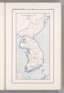
Full Title
Coal Resources of the World. Corea. Map No. 10. Plate I. Map Showing the Distribution of Coal in Corea.
List No
2249.015
Note
Coal in color.
Author
[Kawasaki, H., Tamura, E.]
Full Title
Coal Resources of the World. Corea. Map No. 11. Plate II. Phyong-Yang Coal Field after H. Kawasaki, E. Tamura.
List No
2249.016
Note
In color.
Author
[Ogawa, T., Kido, C.]
Full Title
Coal Resources of the World. Manchuria. Map No. 12. Plate I. Map Showing Showing the Distribution of Coal in Manchuria. (inset) Hsing-King. Plate II. Fu-Shun Coal Field. After T. Ogawa and C. Kido.
List No
2249.017
Note
Two maps on one sheet. Fu-Shun map at 1:85,000.
Full Title
Coal Resources of the World. Manchuria. Map No. 13. Plate III. Section of Coal Seams in Fu-Shun Coal Fields.
List No
2249.018
Full Title
Coal Resources of the World. Japan. Map No. 14. Plate I. Map Showing the Distribution of Coal in Japan. (inset) (Vicinity map of Japan in Asia). (inset) Taiwan.
List No
2249.019
Note
Coal areas shown in color.
Author
Oinouye, Y.
Full Title
Coal Resources of the World. Japan. Map No. 15. Plate II. Ishikari Coal Fields. After Y. Oinouye.
List No
2249.020
Note
Color.
Author
[Kido, C., Suzuki, F., Matsuda, S.]
Full Title
Coal Resources of the World. Japan. Map No. 16. Plate III. Chikuho Coal Field. After F. Suzuki, C. Kido and S. Matsuda.
List No
2249.021
Author
Otsuki, Y.
Full Title
Coal Resources of the World. Japan. Map No. 17. Plate IV. Karatsu and Sasebo Coal Fields. After Y. Otsuki.
List No
2249.022
Note
Coal fields in color.
Full Title
Coal Resources of the World. India. Map No. 18. Coal Fields of India and Adjacent Countries.
List No
2249.023
Note
Coal fields in color.
Full Title
Coal Resources of the World. Turkey. Map No. 19. Asiatic Turkey Showing Location of Known Coal Fields.
List No
2249.024
Note
Coal field locations shown in color.
Full Title
Coal Resources of the World. South Africa. Map No. 20. Section across the Witbank Coalfield.
List No
2249.025
Author
Dowling, D.B.
Full Title
Coal Resources of the World. Canada. Map No. 21. Plate 1. Coal Areas of Canada by D.B. Dowling.
List No
2249.026
Note
Coal areas in color.
Full Title
Coal Resources of the World. Canada. Map No. 22. Plate 2. Coal Fields of Nova Scotia, New Brunswick, Canada.
List No
2249.027
Note
Coal fields shown in color.
Full Title
Coal Resources of the World. Canada. Map No. 23. Plate 3. Sydney Coal Field.
List No
2249.028
Note
Coal shown in color.
Full Title
Coal Resources of the World. Canada. Map No. 27. Plate 8. Southern Vancouver Island, British Columbia.
List No
2249.029
Note
Coal fields in color.
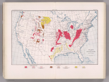
Author
Campbell, Marius R.
Full Title
Coal Resources of the World. United States. Map No. 28. Coal Fields of the United States by Marius R. Campbell.
List No
2249.030
Note
Coal fields shown in color.
Author
Strahan, A.
Full Title
Coal Resources of the World. England and Wales. Map No. 29. Map Showing Visible and Proved Coal Fields of England and Wales prepared under the direction of A. Strahan at the Geological Survey of Great Britain. London 1912.
List No
2249.031
Note
Coal fields in color.
Full Title
Coal Resources of the World. France. Map No. 30. Fig. 2. Carte du Bassin Houiller de Valenciennes. Fig. 3. Coupe E E Passant par Quievrechain. Fig. 4. Coupe D D Passant par Denain. Fig. 5. Coupe C C Passant par l'Escarpelle. Fig. 6. Coupe B B Passant par Meurchin, Lens et Lievin.
List No
2249.032
Note
Scale varies.
Full Title
Coal Resources of the World. France. Map No. 31. Fig. 7. Coupe A A Passant par Bruay. Fig 8. Coupe de Bassin du Boulonnais.... Fig. 10. Carte du Bassin de Ronchamp. Fig. 11. Carte du Bassin de Saint Etienne. Fig. 12. Coupe Transversale du Bassin de Saint-Etienne. Fig. 13. Carte des Bassins de Blanzy, Le Creusot Bert et Forges.
List No
2249.033
Note
Scale varies.
Full Title
Coal Resources of the World. France. Map No. 32. Fig. 14. Carte du Bassin d'Autun - Epinac. Fig. 15. Carte du Bassin de Decize. Fig. 16. Bassins de Commentry, Doyet l'Aumance et Noyant. Fig. 17. Coupe du Gisement de Saint Eloy.
List No
2249.034
Note
Scale varies.
Full Title
Coal Resources of the World. France. Map No. 33. Fig. 18. Carte du Bassin d'Aubin-Decazeville. Fig. 19. Coupe A B du Bassin d'Aubin-Decazeville. Fig. 20. Carte du Bassin de Carmaux-Albi. Fig. 21. Coupe du Bassin de Carmaux-Albi. Fig. 22. Carte du Bassin de Graissessac.
List No
2249.035
Full Title
Coal Resources of the World. France. Map No. 34. Fig. 23. Carte du Bassin d'Alais. Fig. 24. Coupe du Bassin d'Alais par Molieres et la Grand Combe. Fig. 25. Carte Geologique de la Region de la Mure.
List No
2249.036
Note
Scales vary. Color.
Full Title
Coal Resources of the World. France. Map No. 35. Fig. 26. Carte du Bassin de Fuveau. Fig. 27. Coupe S T du Bassin de Fuveau.
List No
2249.037
Note
In color.
Author
de Pann, Charles
Full Title
Coal Resources of the World. Hungary. Map No. 36. Carte des gisements houillers de la Hongrie par Charles de Pann docteur es sciences, 1912. A.M. Foldtani Tarsulat Tulajdona. Metsz. es Nyomt. Posner K. L. es FIA, terkepeszeti muintezete, Budapesten.
List No
2249.038
Note
Coal fields in color.
Author
Petrascheck, W.
Full Title
Coal Resources of the World. Austria. Map No. 37. Karte 1. Ubersichtskarte der Kphlenlager van Oesterreich bearbeitet von Dr. W. Petrascheck.
List No
2249.039
Note
Coal fields in color.
Author
Petrascheck, W.
Full Title
Coal Resources of the World. Austria. Map No. 38. Karte 2. Karte des Trifailer Braunkohlenrevieres ... W. Petrascheck.
List No
2249.040
Author
Petrascheck, W.
Full Title
Coal Resources of the World. Austria. Map No. 39. Karte 3. Ubersichtskarte de Voitsberg - Koflacher Braunkohlenrevieres ... W. Petrascheck.
List No
2249.041
Author
Petrascheck, W.
Full Title
Coal Resources of the World. Austria. Map No. 40. Karte 4. Uebersichts Karte des Teplitz-Brux-Komotauer Braunkohlenrevieres ... W. Petrascheck. Flotz-Profil....
List No
2249.042
Note
Color.
Author
Frieser, A.
Full Title
Coal Resources of the World. Austria. Map No. 41. Karte 5. Flotzkarten des Falkenau-Elbogen-Karlsbader Braunkohlenrevieres ... A. Frieser. Antono Flotz. Agnes Flotz. Josefi Flotz.
List No
2249.043
Author
Frieser, A.
Full Title
Coal Resources of the World. Austria. Map No. 42. Karte 6. Flotzlagerung in den Egerer Braunkohlenmulden ... A. Frieser.
List No
2249.044
Author
Petrascheck, W.
Full Title
Coal Resources of the World. Austria. Map No. 43. Karte 7. Ubersichtskarte des Kladno-Rakonitzer Steinkohlenrevieres ... W. Petrascheck.
List No
2249.045
Note
In color.
Author
Petrascheck, W.
Full Title
Coal Resources of the World. Karte 8. Map No. 44. Karte des Ostrau - Karwin - Krakauer Steinkohlenrevieres entworfen von W. Petrascheck.
List No
2249.046
Note
In color.
Author
Milojkovitch, J.A.
Full Title
Coal Resources of the World. Servia. Map No. 45. Ubersichtskarte der Kohlenvorkommen im Konigreiche Serbien von J.A. Milojkovitch.
List No
2249.047
Full Title
Coal Resources of the World. Roumania. Map No. 46. Esquisse de la distribution des Charbons en Roumanie.
List No
2249.048
Author
Erdmann, Edvard
Full Title
Coal Resources of the World. Sweden. Map No. 47. Geological Map of Skane Compiled by Edvard Erdmann. 1909.
List No
2249.049
Author
[Nathorst, A.G., De Geer, Backlund, Bruce, Hoel]
Full Title
Coal Resources of the World. Spitzbergen (Norway). Map No. 48. Geological Map of Spitzbergen from the Maps of Nordenskiold, De Geer, Tschernyschew, Backlund, Bruce, Hoel, and personal observations by A.G. Nathorst.
List No
2249.050
Note
Color.
Author
Society for the Diffusion of Useful Knowledge (Great Britain)
Full Title
Geological Map of England and Wales.
List No
2326.010
Author
[Campbell, R.A., Worthen, Amos Henry, 1813-1888]
Full Title
Worthens new geological map of Illinois. Prepared expressly for Campbell's Illinois atlas. (Drawn by R.A. Campbell and H.F. Walling). Entered ... 1869 by R.A. Campbell ... Pennsylvania. (1870)
List No
2483.089
Note
Hand colored map. Shows 8 geologic units (Tertiary, Coal measures, Lower Carboniferous, Devonian, Upper Silurian, Cincinnati Group, Trenton Limestone and Calciferous Group). Prime meridians: Greenwich and Washington.
Author
Berghaus, Heinrich
Full Title
Europa in Geologischer Beziehung nach den Hauptmassen der Gebirgs-Formationen. 3te Abtheilung: Geologie, No. 4. Gotha, bei J. Perthes. 1843.
List No
2515.031
Note
A geologic map of Europe showing active volcanoes, and the oldest and newest mountain ranges on the continent. In full color.
Author
Berghaus, Heinrich
Full Title
Die Vulkanischen Erscheinungen Der Atlen Welt, In Und Um Den Atlantischen Ocean. 3te Abtheilung: Geologie, No. 7. Potsdam, gestochen in der geographischen Kunstschule. Gotha, bei J. Perthes, 1839.
List No
2515.034
Note
Map shows the range of volcanic and earthquake activity throughout the world. In outline color are three different earthquake regions with dates of activity ranging from 1755-1838.
Author
Berghaus, Heinrich
Full Title
Specialia vom Vulkan Gurtel des Atlantischen Oceans. 3te Abtheilung: Geologie, No. 8. Gezeichnet von F. Schelle. Gestochen von Joh. Carl Ausfeld. Gotha, J. Perthes, 1839.
List No
2515.035
Note
Thirteen maps showing volcanic activity throughout the Atlantic and Mediterranean Oceans. Detailed outline colored maps are accompanied by drawings of exploding volcanoes, calderas, and volcanic mountain ranges.
Author
Berghaus, Heinrich
Full Title
Karte von dem Vulkan Gurtel und dem Central Gruppen des Grossen Oceans; nach Leopold v. Buch; von Berghaus. Potsdam, 16 Juli 1838. 3te Abtheilung: Geologie, No. 9. Gezeichnet von F. Schelle. In Potsdam Gestochen von K. Kolbe. Gotha, J. Perthes, 1838.
List No
2515.036
Note
Map of the Pacific Ocean showing volcanic and earthquake activity. Circled regions of activity include the Philippines and Central America. In outline color.
Author
Berghaus, Heinrich
Full Title
Die Vulkanreihe von Guatemala, die Landengen von Tehuantepec, Nicaragua und Panama, und die Central Vulkane der Sud See. 3te Abtheilung: Geologie, No. 10. Potsdam, gez. u. gest. in der geogr. Kunstschule. Gotha, bei J. Perthes, 1840.
List No
2515.037
Note
Maps in outline color. Main map is of Central America. Nine inset maps detail the volcanic regions of Central America and the islands in the Pacific Ocean and South Seas. Side views of Costa Rica, Guatemala, and the isthmus of Tehuantepec are included.
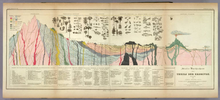
Author
Berghaus, Heinrich
Full Title
Idealer Durchschnitt eines Theils Der Erdrinde. Verfafst von Thomas Webster, F.G.S. &c. Die Pflanzen und Thiere nach der Auswahl und Anordnung des Dr. Buckland gezeichnet von Joseph Fischer. Potsdam, gestochen in der geographischen Kunstschule, die Figuren von J.C. Ausfeld. 3te Abtheilung: Geologie, No. 11. Gotha, J. Perthes, 1841.
List No
2515.038
Note
A full color "ideal" geologic cross section with a detailed key explaining all of the notations on the map. Above the section are numerous drawings of plants, animals, and sea life.
Author
Berghaus, Heinrich
Full Title
Geologische Karte von Deutschland und den anlieg. Landern nach des Bergmeister's H. Credner Zusamenstellung. 1843. 3te Abtheilung: Geologie, No. 12. Gotha, bei J. Perthes.
List No
2515.039
Note
A full color geologic map of Germany accompanied by two keys.
Author
Berghaus, Heinrich
Full Title
Spezial-Karte vom Riesen-Gebirge. 3te Abtheilung: Geologie, No. 13. Gezeichnet u. gestochen in der geogr. Kunstschule zu Potsdam. Gotha, J. Perthes, 1843.
List No
2515.040
Note
Geologic map of the Reisengebirge (or Krkonose, Karkonosze or Giant Mountains) in the Czech Republic and Poland.
Author
Berghaus, Heinrich
Full Title
Geologische Profile von Deutschland im Allgemeinen u. von Riesengebirge im Besondern; Sammt Einer Karte vom Tertiar Becken von Paris. 3te Abtheil: Geologie, No. 14. Gezeichnet von H. Credner. Gest. v. E.G. Edler. Gotha, bei J. Perthes, 1845.
List No
2515.041
Note
A full color geologic map of France and numerous full color geologic cross sections of Germany. A key is included.
Author
Berghaus, Heinrich
Full Title
Vermischtes zur Geologie. 3te Abtheilung: Geologie, No. 15. Potsdam, gez. u. gest. in der geogr. Kunstschule. Gotha, bei J. Perthes, 1844.
List No
2515.042
Note
Miscellaneous geological maps, charts, and information. Some color. Maps include the Quito Plateau, the Himalayas, and the crater on Java. The heights of the Himalayan mountains are shown.
Author
Newberry, John S.
Full Title
Geological map of Ohio by J.S. Newberry, Chief Geologist, 1872. (Published by Stedman, Brown & Lyon, Cincinnati. 1872. Entered ... 1872, by H.F. Walling, and O.W. Gray, and H.H. Lloyd & Co. ... Washington)
List No
2710.002
Note
Col. lithographed map. Includes "Section through northern Ohio," "Section from Cincinnati to Marietta," and explanation of colors.
Author
Wheeler, G.M.
Full Title
(Title Page to) Geological Atlas Projected To Illustrate Geographical Explorations And Surveys West Of The 100th Meridian Of Longitude Prosecuted In Accordance With Acts Of Congress Under The Authority Of The Honorable The Secretary Of War, And The Direction Of Brig. Genl. A.A. Humphreys, Chief Of Engineers, U.S. Army. Embracing Results Of the Different Expeditions Under The Command Of 1st Lieut. Geo. M. Wheeler, Corps Of Engineers. Julius Bien, lith.
List No
2738B
Note
Signed by Ovando Hollister.
Author
Wheeler, G.M.
Full Title
(Cover to) Geographical Explorations And Surveys West Of The 100th Meridian. Geological Atlas. Wheeler. 1874.
List No
2738D
Author
Wheeler, G.M.
Full Title
(Composite map of) All Wheeler Geological Atlas Sheets
List No
2738.116
Note
Composite map of all the Wheeler geological sheets. The map images are projected in GIS on a conic projection with the central meridian at 111 degrees west - matching the original projection of the Wheeler Survey. The index sheet composite shows all the sheet names and dates.
Author
Wheeler, G.M.
Full Title
(Composite map of) Index of all Wheeler Geological Atlas Sheets
List No
2738.117
Note
Composite index map of all the Wheeler geological sheets. The map images are projected in GIS on a conic projection with the central meridian at 111 degrees west - matching the original projection of the Wheeler Survey. The index sheet composite shows all the sheet names and dates, at a lower resolution.
Author
Wheeler, G.M.
Full Title
Central & Western Utah Atlas Sheet Number 50. Weyss, Herman & Aguirre Del. Expeditions of 1872 & 1873, Under the Command of 1st Lieut. Geo. M. Wheeler, Corps of Engineers, U.S. Army. U.S. Geographical Surveys West Of The One Hundredth Meridian.
List No
2738.036
Note
Full color geologic formations shown in crayon on map base used in P1281-64. Salt Lake City placed outside the map border. Color legend provided at right of map.
Author
Wheeler, G.M.
Full Title
Atlas Sheet Number 58. Parts Of E. California, S.E. Nevada, N.W. Arizona & S.W. Utah. Atlas Sheet Number 66. Weyss, Herman & Aguirre, Del. Expeditions of 1872 & 1873, Under the Command of 1st. Lieut. Geo. M. Wheeler, Corps of Engineers, U.S. Army. Geological Assistants: G.K. Gilbert, A.R. Marvine and E.E. Howell. U.S. Geographical Surveys West Of The One-Hundredth Meridian.
List No
2738.045
Note
Two partial atlas sheets on one page. In crayon and showing geological formations in tints. Color legend on outside of each map.
Author
Wheeler, G.M.
Full Title
Southern And Southwestern Utah. Atlas Sheet Number 59. Weyss, Herman & Aguirre, Del's. Expeditions of 1872 & 1873 Under the Command of 1st. Lieut. Geo. M. Wheeler, Corps of Engineers, U.S. Army. Geological Assistants: G.K. Gilbert, A.R. Marvine, E.E. Howell. Explorations & Surveys West Of The One-Hundredth Meridian.
List No
2738.048
Note
In crayon and showing geological formations in full color tints. Legend to the right of map. Top left of map without geologic representation.
Author
Wheeler, G.M.
Full Title
Parts Of Northern & North Western Arizona & Southern Utah, Atlas Sheet No. 67. Weyss, Herman & Lang, Del. Expeditions of 1871, 1872, & 1873. Under the Command of 1st. Lieut. Geo. M. Wheeler, Corps of Engineers, U.S. Army. G.K. Gilbert, A.R. Marvine, E.E. Howell, Geological Assistants. U.S. Geographical Surveys West Of The 100th Meridian.
List No
2738.069
Note
Grand Canyon sheet using crayon as in P1281-118 with full color tint overlay of geologic formations. Legend to the right of the map border.
Author
Wheeler, G.M.
Full Title
Parts of Atlas Sheets Nos. 69(B), 69(D), 77(B) and 78(A). (with) Parts of North Central New Mexico ... Southern Colorado and Northern New Mexico. Issued June 30, 1881. Expeditions of 1873, 1878 and 1879 Under the Command of 1st. Lieut. Geo. M. Wheeler, Corps of Engineers, U.S. Army. Prof. John J. Stevenson, Geological Assistant. U.S. Geographical Surveys West Of The 100th Meridian.
List No
2738.073
Note
Four separate maps with hachures showing geologic formations in full color. Legend included.
Author
Wheeler, G.M.
Full Title
Parts Of Southern Colorado And Northern New Mexico, Atlas Sheet No. 70 (A.). Issued May 7th 1877. 2nd Ed. June 30th 1881. Weyss, Herman & Mahlo Del. Expeditions of 1878 & 1879 Under the Command of 1st. Lieut. Geo. M. Wheeler, Corps of Engineers, U.S. Army. Prof. John J. Stevenson, Geological Assistant. U.S. Geographical Surveys West Of The 100th Meridian.
List No
2738.078
Note
Base map P1281-128 with overlay of geologic formations in full color. Legend along bottom of map sheet.
Author
Wheeler, G.M.
Full Title
Part Of North Central New Mexico-Atlas Sheets No. 70, (C.). Issued May 7th 1877. 2nd. Ed. June 30th, 1881. Weyss, Herman & Lang Del. Expeditions of 1878 & 1879 Under the Command of 1st. Lieut. Geo. M. Wheeler, Corps of Engineers U.S. Army. Prof. John J. Stevenson, Geological Assistant. U.S. Geographical Surveys West Of The 100th Meridian.
List No
2738.081
Note
In hachures as in P1281-132 with geological formations shown in full color.
Author
Wheeler, G.M.
Full Title
Parts Of Central & Western Arizona - Atlas Sheet No. 75. Issued Feb'y. 15 1877. Weyss, Herman & Lang Del. Expeditions of 1871, 1872 & 1873, Under the Command of 1st. Lieut. Geo. M. Wheeler, Corps of Engineers, U.S. Army. Geological Assistants: Prof. Jul. Marcou, G.K. Gilbert, A.R. Marvine. U.S. Geographical Surveys West Of The 100th Meridian.
List No
2738.086
Note
Base map of P1281-140 overlaid with full color representation of geological formations.
Author
Wheeler, G.M.
Full Title
Parts Of Eastern Arizona And Western New Mexico Atlas Sheet No. 76. Issued Feb'y. 15 1877. Weyss, Herman & Lang Del. Expeditions of 1871, 1872 & 1873, Under the Command of 1st. Lieut. Geo. M. Wheeler, Corps of Engineers, U.S. Army. Geological Assistants: G.K. Gilbert, A.R. Marvine, E.E. Howell. U.S. Geographical Surveys West Of The 100th Meridian.
List No
2738.088
Note
Base map P1281-142 showing geological formations in full color. Index to features at right. Ft. Defiance placed outside the top border.
Author
Wheeler, G.M.
Full Title
Parts Of Eastern & Southeastern Arizona, Western & Southwestern New Mexico - Atlas Sheet, No. 83. Issued Feb'y. 15 1877. Weyss, Herman & Lang Del. Expeditions Of 1871 & 1873. Under the Command of 1st. Lieut. Geo. M. Wheeler, Corps of Engineers, U.S. Army. Geological Assistants: G.K. Gilbert, E.E. Howell and Dr. O. Loew. U.S. Geographical Surveys West Of The 100th Meridian.
List No
2738.098
Note
In full color showing geological formations over base map P1281-152. No geologic information for bottom left and upper left corners. C. Lowell (left) and C. Bowie (center) outside lower border. Ft. Bayard outside right border.
Author
Lange, Henry, 1821-1893.
Full Title
Michigan. (with 2 inset maps) Lake Superior (with) Geologische Karte der Isle Royale. H. Lange's Atlas v. Nord Amerika Blatt X. Braunschweig: Verlag v. George Westermann. Lith. Anst. von L. Kraatz in Berlin.
List No
2743.010
Note
Engraved map. Borders hand col. Shows roads, railroads, etc. Relief shown by hachures.
Author
Maclure, William
Full Title
(Title Page to) Observations on the Geology of the United States, explanatory of a Geological Map. By William Maclure. Read January 20th, 1809. (In) Transactions of the American Philosophical Society, Held at Philadelphia, for promoting Useful Knowledge. Volume VI. Published by C. and A. Conrad and Co. Philadelphia. ... Jane Aitken, Printer. 1809.
List No
2749A
Note
1st edition of the first geological map of U.S. A portion of a map of the U.S. by Samuel Lewis is used to make this map. The full sheet of paper was put on a larger plate and pulled, leaving the upper and right side without borders, as issued. Uncut and untrimmed, the map appears here with Maclure's original essay on the geology of the U.S. In 1817 Maclure published an expanded versus of his essay, using the small Melish Map of the U.S. as a base. Maclure was dissatisfied with the Lewis map because of its rendering of the mountains, and an errata slip is attached to the back of p 423 explaining this (and stating that originally it was intended to use a reduction of the Bradley U.S. map). See Marcou 1858 for more discussion of the Lewis map. Maclure did a Paris printing of the article and Map (using a map by Volney as a base) in 1811, in French. The Lewis map is most likely the Map of the U.S. published in the 2nd edition of Carey's American Atlas, 1809 (P-Maps p 876,Walsh). Maclure's map and essay are very rare. There is an inscription on the title page to "Mons. F.A. Michaux-Paris, from his friend..." Map bound into the back of paper covered boards with the title handwritten on the spine. Map in full color by geologic structure.
Author
Maclure, William
Full Title
(Text Page to) Observations on the Geology of the United States, explanatory of a Geological Map. By William Maclure. Read January 20th, 1809. (In) Transactions of the American Philosophical Society, Held at Philadelphia, for promoting Useful Knowledge. Volume VI. Published by C. and A. Conrad and Co. Philadelphia. ... Jane Aitken, Printer. 1809.
List No
2749B
Author
Maclure, William
Full Title
A Map of the United States of America. By Samuel G. Lewis.
List No
2749.001
Author
Hayden, F.V.
Full Title
(Title Page to) Geological Report of the Exploration of the Yellowstone and Missouri Rivers by Dr. F.V. Hayden, Assistant, under the direction of Captain (now Lieut. Col. and Brevet Brig. Gen.) W.F. Raynolds, Corps of Engineers, 1859-'60. Washington: Government Printing Office. 1869.
List No
2769A
Author
Hayden, F.V.
Full Title
U.S. War Department Map Of The Yellowstone And Missouri Rivers And Their Tributaries explored by Capt. W.F. Raynolds Topl. Engrs. and 1st Lieut. H.E. Maynadier 10th Infy. Assistant. 1859-60. To accompany a report to the Bureau of Topographical Engineers. Lt. Col. Harman Bache in charge. Engraved in the Engineer Bureau War Dept. Prepared to accompany the Geological Report of F.V. Hayden M.D. ... Printed by Julius Bien, N.Y.
List No
2769.001
Note
Map from the report of 1869. Striking, full color, large geological map based on Raynold's "Yellowstone" map.
Author
[Andreas, A. T. (Alfred Theodore), 1839-1900, Winchell, N. H. (Newton Horace), 1839-1914]
Full Title
Geological map of Minnesota by N.H. Winchell, State Geologist. (with) Colored to show senatorial districts, apportionment of 1871. (with) Colored to show judicial districts. (with) Colored to show congressional districts. (Published by A.T. Andreas, Lakeside Building, Chicago, 1874. Chas. Shober & Co. Proprietors of Chicago Lith. Co.)
List No
3034.004
Note
Four col. lithographed maps. Geological map includes 2 cross sections and explanation.
Author
[Hitchcock, Charles H. (Charles Henry), 1836-1919, New Hampshire. Geological Survey]
Full Title
(Title Page to) Atlas accompanying the report on the geology of New Hampshire. C.H. Hitchcock, State Geologist. 1878. Julius Bien, New York.
List No
3095A
Note
17 maps and plates as called for in Vol III, p.vii of text. Huge folio atlas with 2 plates of views, 2 facsimiles (Carrigain 1816 and Holland 1784), 1 diagram or Camera view, a 6 sheet Geological Map of the state, a 5 (of 6, as issued) sheet Map of the state's Surface Geology, and a map of the Ammonoosuc Mining District. The upper northwest sheet of the Surface Geology map was not printed because it is entirely of Vermont, except for a tiny part of the lower right corner which was covered by making the uppper northeast sheet about one inch wider in the Surface Geology issue than it is in the Geological (six sheet) issue. The matter is further confused by Sabin calling for 16 plates and Phillips and LeGear calling for 9. Cobb calls for 17 and the most important list, in the text of the report itself, calls for 17. We believe this was the only large folio Geological Atlas made of an eastern state, on the scale of the western survey atlases of Powell, Hayden, Wheeler and King, during the same period. Most maps have printed color although the Ammonoosuc Mining District map is fully hand colored.
Author
[Hitchcock, Charles H. (Charles Henry), 1836-1919, New Hampshire. Geological Survey]
Full Title
(General geological map of New Hampshire, embracing portions of Maine, Vermont, and Quebec. Sheet 1. Julius Bien, New York, 1878)
List No
3095.005
Note
Col. lithographed map. Sheet 1 of 6. Includes explanation and 5 cross sections. Vertical and horizontal scale 2 1/2 miles to an in. Contour inverval 100 ft. Title from Marcou. Explanation is in v. 2, p. 672 of "Geology of New Hampshire."
Author
[Hitchcock, Charles H. (Charles Henry), 1836-1919, New Hampshire. Geological Survey]
Full Title
(General geological map of New Hampshire, embracing portions of Maine, Vermont, and Quebec. Sheet 2. Julius Bien, New York, 1878)
List No
3095.006
Note
Col. lithographed map. Sheet 2 of 6. Includes explanation and 5 cross sections. Vertical and horizontal scale 2 1/2 miles to an in. Contour inverval 100 ft. Title from Marcou. Explanation is in v. 2, p. 672 of "Geology of New Hampshire."
Author
[Hitchcock, Charles H. (Charles Henry), 1836-1919, New Hampshire. Geological Survey]
Full Title
(General geological map of New Hampshire, embracing portions of Maine, Vermont, and Quebec. Sheet 3. Julius Bien, New York, 1878)
List No
3095.007
Note
Col. lithographed map. Sheet 3 of 6. Includes explanation and 4 cross sections. Vertical and horizontal scale 2 1/2 miles to an in. Contour inverval 100 ft. Title from Marcou. Explanation is in v. 2, p. 672 of "Geology of New Hampshire."
Author
[Hitchcock, Charles H. (Charles Henry), 1836-1919, New Hampshire. Geological Survey]
Full Title
(General geological map of New Hampshire, embracing portions of Maine, Vermont, and Quebec. Sheet 4. Julius Bien, New York, 1878)
List No
3095.008
Note
Col. lithographed map. Sheet 4 of 6. Includes explanation and 4 cross sections. Vertical and horizontal scale 2 1/2 miles to an in. Contour inverval 100 ft. Title from Marcou. Explanation is in v. 2, p. 672 of "Geology of New Hampshire."
Author
[Hitchcock, Charles H. (Charles Henry), 1836-1919, New Hampshire. Geological Survey]
Full Title
(General geological map of New Hampshire, embracing portions of Maine, Vermont, and Quebec. Sheet 5. Julius Bien, New York, 1878)
List No
3095.009
Note
Col. lithographed map. Sheet 5 of 6. Includes explanation and 5 cross sections. Vertical and horizontal scale 2 1/2 miles to an in. Contour inverval 100 ft. Title from Marcou. Explanation is in v. 2, p. 672 of "Geology of New Hampshire."
Author
[Hitchcock, Charles H. (Charles Henry), 1836-1919, New Hampshire. Geological Survey]
Full Title
(General geological map of New Hampshire, embracing portions of Maine, Vermont, and Quebec. Sheet 6. Julius Bien, New York, 1878)
List No
3095.010
Note
Col. lithographed map. Sheet 6 of 6. Includes explanation and 5 cross sections. Vertical and horizontal scale 2 1/2 miles to an in. Contour inverval 100 ft. Title from Marcou. Explanation is in v. 2, p. 672 of "Geology of New Hampshire."
Author
[Hitchcock, Charles H. (Charles Henry), 1836-1919, New Hampshire. Geological Survey]
Full Title
(Composite of General geological map of New Hampshire, embracing portions of Maine, Vermont, and Quebec. Julius Bien, New York, 1878)
List No
3095.011
Note
Col. lithographed map on 6 sheets. Each sheet includes explanation and 4-5 cross sections. Vertical and horizontal scale 2 1/2 miles to an in. Contour inverval 100 ft. Title from Marcou. Explanation is in v. 2, p. 672 of "Geology of New Hampshire." Covers adjacent areas of Maine, Vermont and Quebec.
Author
[Hitchcock, Charles H. (Charles Henry), 1836-1919, New Hampshire. Geological Survey]
Full Title
(Topographic and glacial feature map of New Hampshire. Sheet 1. Julius Bien, New York, 1878)
List No
3095.012
Note
Col. lithographed map. Sheet 1 of 5. Shows townships, grants, railroads, areas of glacial striae, lenticular hills, slopes of till, modified drift, etc. Scale (2 1/2 miles to an in.) Contour inverval 100 ft.
Author
[Hitchcock, Charles H. (Charles Henry), 1836-1919, New Hampshire. Geological Survey]
Full Title
(Topographic and glacial feature map of New Hampshire. Sheet 2. Julius Bien, New York, 1878)
List No
3095.013
Note
Col. lithographed map. Sheet 2 of 5. Shows townships, grants, railroads, areas of glacial striae, lenticular hills, slopes of till, modified drift, etc. Scale (2 1/2 miles to an in.) Contour inverval 100 ft.
Author
[Hitchcock, Charles H. (Charles Henry), 1836-1919, New Hampshire. Geological Survey]
Full Title
(Topographic and glacial feature map of New Hampshire. Sheet 3. Julius Bien, New York, 1878)
List No
3095.014
Note
Col. lithographed map. Sheet 3 of 5. Shows townships, grants, railroads, areas of glacial striae, lenticular hills, slopes of till, modified drift, etc. Scale (2 1/2 miles to an in.) Contour inverval 100 ft.
Author
[Hitchcock, Charles H. (Charles Henry), 1836-1919, New Hampshire. Geological Survey]
Full Title
(Topographic and glacial feature map of New Hampshire. Sheet 4. Julius Bien, New York, 1878)
List No
3095.015
Note
Col. lithographed map. Sheet 4 of 5. Shows townships, grants, railroads, areas of glacial striae, lenticular hills, slopes of till, modified drift, etc. Scale (2 1/2 miles to an in.) Contour inverval 100 ft.
Author
[Hitchcock, Charles H. (Charles Henry), 1836-1919, New Hampshire. Geological Survey]
Full Title
(Topographic and glacial feature map of New Hampshire. Sheet 5. Julius Bien, New York, 1878)
List No
3095.016
Note
Col. lithographed map. Sheet 5 of 5. Shows townships, grants, railroads, areas of glacial striae, lenticular hills, slopes of till, modified drift, etc. Scale (2 1/2 miles to an in.) Contour inverval 100 ft.
Author
[Hitchcock, Charles H. (Charles Henry), 1836-1919, New Hampshire. Geological Survey]
Full Title
(Composite of Topographic and glacial feature map of New Hampshire. Sheet 5. Julius Bien, New York, 1878)
List No
3095.017
Note
Col. lithographed map. Sheet 5 of 5. Shows townships, grants, railroads, areas of glacial striae, lenticular hills, slopes of till, modified drift, etc. Scale (2 1/2 miles to an in.) Contour inverval 100 ft. Issued in 5 sheets (6th would have been upper left sheet not covering New Hampshire).
Author
[Hitchcock, Charles H. (Charles Henry), 1836-1919, New Hampshire. Geological Survey]
Full Title
Map of the Ammonoosuc Mining District. (Julius Bien, New York, 1878) The Heliotype Printing Co. 220 Devonshire St., Boston.
List No
3095.018
Note
Hand col. lithographed map. Shows geological units, mines, townships, etc. Contour inverval 100 ft. Oriented with north toward upper left.
Author
[Drioux, Claude-Joseph, Leroy, Charles]
Full Title
France : Hypsometrique : Relief du sol. Par M.Mrs. Drioux et Ch. Leroy. Dessine par Vilpou. ... Grave par F. Dufour. Librairie Classique Eugene Belin Paris. (inset) Corse. (to accompany) Atlas Universel Et Classique De Geographie ...1886. (insets) France geologique . (with inset) Corse; Coupe ideale de l'ecorce terrestre.
List No
3277.032
Note
Color hypsometric and geologic map of France. Includes cross section of the earth's crust. Relief shown by gradient tints and spot heights. Shows terrains, rivers, mountains, etc.
Author
Rogers, Henry Darwin
Full Title
A Geological Map of New Jersey, by Henry D. Rogers, Prof. of Geology in Univ. of Penna. (To accompany the Report on the Geology of N. Jersey,) Jan. 1839. P.S. Duval, Lith. Philada. On Stone by J. Probst.
List No
3346.000
Note
Marcou lists this as the first Geological map of New Jersey. Accompanies Rogers' "Description of the geology of the State of New Jersey, being a final report," Philadelphia, 1840. Report not present here. Rodgers used the Gordon/Tanner map as a base. Full color by geological formation. Relief shown by hachures.
Author
[Blake, William P. (William Phipps), 1826-1910, Hitchcock, Charles H. (Charles Henry), 1836-1919, United States. Census Office]
Full Title
Geological map of the United States compiled by C.H. Hitchcock and W.P. Blake from sources mentioned in the text. 1874. Lith. by J. Bien, N.Y.
List No
3566.010
Note
Colored lithographed map. Shows 9 geologic units.
|