|
REFINE
Browse All : Geology of Lake Superior
1-13 of 13
Author
Owen, David Dale
Full Title
Table I C. Fossil, plants, (?) from the Red Sandstones on the Noethwest shore of Lake Superior. From drawings, by J. Chappellsmith. (on opposite page view by) J. Cappell Smith, del. J.M. Butler. (to accompany) Illustrations to the Geological Report of Wisconsin, Iowa, and Minnesota. (with) Report of a Geological Survey of Wisconsin, Iowa and Minnesota ... 1852.
List No
0690.008
Note
Descriptive list of the specimens and 8 uncolored views.
Author
Owen, David Dale
Full Title
Table I D. Mud Furrows, (?) and impressions of plants (?), in the red sandstones of the northwest shore of Lake Superior. Medal ruled on steel from original specimens. (on opposite page view) by R. Whitechurch & B. P. Newman at J. M. Butler's Establishment. (to accompany) Illustrations to the Geological Report of Wisconsin, Iowa, and Minnesota. (with) Report of a Geological Survey of Wisconsin, Iowa and Minnesota ... 1852.
List No
0690.009
Note
Descriptive list of the specimens and 3 uncolored views.
Author
Owen, David Dale
Full Title
Table II. Trilobites, from F. III., A; Gasteropoda and Brachipoda, from F. II., and F. III., A; Together with Fucoidal impressions, (?) from the red sandstones of Lake Superior. (on opposite page view) D.D. Owen, del. J. M. Butler. (to accompany) Illustrations to the Geological Report of Wisconsin, Iowa, and Minnesota. (with) Report of a Geological Survey of Wisconsin, Iowa and Minnesota ... 1852.
List No
0690.010
Note
Descriptive list of the specimens and 13 uncolored views.
Author
Owen, David Dale
Full Title
General connected section of the rocks exposed on the North shore of Lake Superior between Fond du Lac Superieur and Pigeon Point, as observed during the geological surveys of Wisconsin & Minnesota territory, in the year 1848, 49 & 50, under the direction of David Dale Owen, M.D. United States Geologist. By Richard Owen. (to accompany) Illustrations to the Geological Report of Wisconsin, Iowa, and Minnesota. (with) Report of a Geological Survey of Wisconsin, Iowa and Minnesota ... 1852.
List No
0690.034
Note
Hand color geologic cross section on sheet 31x135 cm. folded to 31x20. with explanation of rock formations.
Author
Owen, David Dale
Full Title
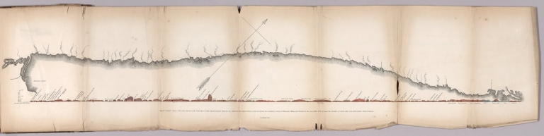
Geological map: Coast view and section of Pigeon Point. By Richard Owen. Engd. on steel by W.H. Dougal, Washington, D.C. Cost section from the West end of Grand Portage Bay to the extremity of Pigeon Point in direction North of East. By Richard Owen. (on upper right margin) Pl.N. (to accompany) Illustrations to the Geological Report of Wisconsin, Iowa, and Minnesota. (with) Report of a Geological Survey of Wisconsin, Iowa and Minnesota ... 1852.
List No
0690.035
Note
Hand color geologic map and cross section, folded to 31x21 cm., with uncolored view of the coast folded to 31x20 cm. On upper right margin Pl.N.
Author
Owen, David Dale
Full Title
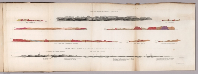
Outline of the hills on Grand Portage of Pigeon River, North of Lake Superior: as seen from hill 650 feet high - 4 1/2 miles north of Grand Portage Bay. (with) Outline of the hills and ridges of the north shore of Lake Superior as seen from the top of the Great Palisade Rock. From an outline by J.G. Norwood. Engraved & printed by J.M. Butler. (to accompany) Illustrations to the Geological Report of Wisconsin, Iowa, and Minnesota. (with) Report of a Geological Survey of Wisconsin, Iowa and Minnesota ... 1852.
List No
0690.036
Note
Hand color geologic cross sections, folded to 31x21 cm., showing geologic formations. With 2 uncolored outline view of hills north shore of Lake Superior showing elevation in feet, Includes detail explanation. On upper right margin Pl. 1 N.
Author
Owen, David Dale
Full Title
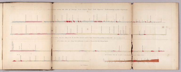
No. 1: Section cross the line of bearing from Pigeon Point Lake Superior, North Westerly, to Lake Saganaga. No. 2: Section from the valley of the St. Croix River near the mount of Upper Pinnette River, northerly, to Rainy Lake. No. 3: Section from near Portage Lake southeasterly to a point on Wisconsin River below Whitney's Rapids. No. 4: (untitled: from Big Bull Falls to Whitney's Mill) No. 5: Section from the mouth of Kinechegakwag Cr. toward Cloquet River. by J.G. Norwood. Engraved & printed by J.M. Butler. (to accompany) Illustrations to the Geological Report of Wisconsin, Iowa, and Minnesota. (with) Report of a Geological Survey of Wisconsin, Iowa and Minnesota ... 1852.
List No
0690.037
Note
5 geologic cross sections, hand colored, folded to 31x21 cm. Includes detail explanation. On upper left margin Pl. 2 N.
Author
Owen, David Dale
Full Title
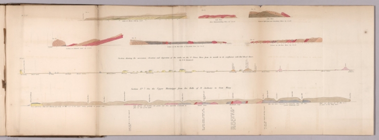
Sec. 1. Section on Mission Creek, by J.G.N. Sec.2. Lake shore above Kamanasisatikag River, by J.G.N. Sec. 3. Lake shore between Split Rock and Gooseberry River, by J.G.N. Sec.4. Section of Palisade River, by J.G.N. Sec 4, S. Section showing the succession, elevation and depression of the rocks on the St. Peters River... By F. B. Shumard. Sec. 5. Section on the west fork of Palisade River, by J.G.N. Sec. 6. Section on Cut-Face River, by J.G.N. Section No. 7, on the upper Mississippi from the falls to St. Anthony to Corw Wing. (to accompany) Illustrations to the Geological Report of Wisconsin, Iowa, and Minnesota. (with) Report of a Geological Survey of Wisconsin, Iowa and Minnesota ... 1852.
List No
0690.038
Note
8 geologic cross sections, hand colored, folded to 31x21 cm. Includes detail explanation. On upper left margin Pl. 3 N.
Author
Owen, David Dale
Full Title
No.1. Section of the summit levels, showing the general elevation of the country between the mouth of Chippewa river and the mouth of Bad River, above lake Superior. No. 2. Section of the summit levels, showing the general elevation of the country between the Mississippi River, at St. Pauls, and St. Louis river ... No. 3. Section of the summit levels, showing the general elevation of the country between the Mississippi river at the outlet of Lake St. Croix and the mouth of Bois Brule river. From Barometrical Measurements make during a Geological Reconnoisance of the Chippewa Land District, under the direction of David Dale Owen, ... and J.G. Norwood ... (to accompany) Illustrations to the Geological Report of Wisconsin, Iowa, and Minnesota. (with) Report of a Geological Survey of Wisconsin, Iowa and Minnesota ... 1852.
List No
0690.039
Note
3 uncolored cross sections, folded to 31x21 cm. Includes detail explanation.
Author
Owen, David Dale
Full Title
Sections accompanying the report of Chas. Whittlesey on the Bad River District of south shore Lake Superior. Elevation principally by Dr. Norwood. Ackerman Lith. 379 Broadway N.Y. (to accompany) Illustrations to the Geological Report of Wisconsin, Iowa, and Minnesota. (with) Report of a Geological Survey of Wisconsin, Iowa and Minnesota ... 1852.
List No
0690.049
Note
4 color cross sections, folded to 31x21 cm. Includes: Section No.1.W. Section from the mouth of Apukwaekan of Flag River, south east by south 55 miles to the head of Tyler's Fork. (with)m Section No.2.W. Section of the rocks from the Maringouin Fork of Bad River ... (with) Section No.3.W. Section from the Falls of the East Fork to Bad River ... (with) Section No.4. W. Section from the mouth of Montreal River ... Includes notes.
Author
Owen, David Dale
Full Title
Sec. 2.N. Section by A. Randall along the line of the 4th. P.M. from Lake Superior to the Mississippi ... (with) Section by A. Randall along the 3rd. correction from the Mississippi R. to 4th. P.M. Sec.3 R. Section of hills at the Chippewe red pipestone locality between the Chippewe and Red Cedar Rivers ... By A. randall. Sec. 1 R. Section on Black river from granite at the Falls to sandstone F.1.a. By A. Randall. (with) Geological section at Falls of St. Anthony. By B.F. Shumard. Ackerman Lith. 379 Broadway N.Y. (to accompany) Illustrations to the Geological Report of Wisconsin, Iowa, and Minnesota. (with) Report of a Geological Survey of Wisconsin, Iowa and Minnesota ... 1852.
List No
0690.050
Note
5 color cross sections, folded to 31x21 cm.
Author
Owen, David Dale
Full Title
Geological map of Wisconsin, Iowa and Minnesota : exhibiting, also, the extension of the Iowa coal-field into Missouri, and its relation to the Illinois coal-field / constructed from observations by the United States Geological Corps, under instructions from the Secretary of the Treasury, by David Dale Owen ; middle, northern and northeastern Minnesota by J.G. Norwood ; the greater part of the southern shore of Lake Superior, in Wisconsin, by Col. Chas. Whittlesey. 1851. Engraved by W. Smith. Washn. (to accompany) Illustrations to the Geological Report of Wisconsin, Iowa, and Minnesota. (with) Report of a Geological Survey of Wisconsin, Iowa and Minnesota ... 1852. Inset: Geological map of the north shore of Lake Superior : on the scale of the original m.s. map. Scale [ca. 1:600,000].
List No
0690.052
Note
Hand colored geological map. Shows geological formations via hand coloring. It also shows the Iowa coal-field extending into northern Missouri and part of the Illinois coal-field. There is excellent detail of watershed and lakes throughout. Includes Table showing geological formation by color.
Author
[Whitney, J.D., Foster, J.W.]
Full Title
Carte geologique du Lac Superieur. Etat De Michigan. Drefsee par M.rs J.W. Fosters et J.D. Whitney geologues des Etats Unia. Annales des Mines, 5e Serie, Tome VII, pages 173 et suivantes. Lemaitre sc. Voyage au Lac Superieur. Geologie. Pl. VI.
List No
5290.000
Note
This is a French issue of the Foster/Whitney geological maps of Lake Superior from the 1849 report (see our #1059). Hand-painted color shows geologic formation in the Lake Superior vicinity.
1-13 of 13
|