|
Author
Arrowsmith, John, 1790-1873
Full Title
The inland navigation, rail roads, geology, and minerlas of England & Wales, by J. Arrowsmith. London, pubd. 15 Feby. 1842, by J. Arrowsmith, 10 Soho Square.
List No
14506.011
Note
Map representing England and Wales. Shows counties, cities, railways, topography, bodies of water, drainage, coastlines and islands. Relief shown with hachures. Includes a legend, table of geological groups, lines of navigation, and latitudinal and longitudinal lines, as well as bar scales given in geographical and English miles. Hand-colored engraving. Map is 63 x 50 cm, on double sheet 68 x 56 cm.
Author
Knipe, James Alexander
Full Title
Geological & Mineralogical Map Of England And Wales, With Parts Of Scotland, Ireland & France, Showing also the Inland Navigation By means of Rivers & Canals, With their Elevation in feet above the Sea, The Rail Roads & Principal Roads, By J.A. Knipe ... T.W. Saunders, 6, Charing Cross) Published By J.A. Knipe, Jany. 1st 1847, and may be had of the Engraver, J. Dower, 6, Cumming Place, Pentonville, London. (Messrs. Grant & Griffith St. Pauls Ch. Yd. (late Harris). Designed and Drawn by J.A. Knipe. Engraved by I. Dower, Pentonville, London. (with 7 inset profiles).
List No
2051.002
Author
Geikie, Archibald
Full Title
"Geological Map of England and Wales Reduced chiefly from the Ordnance and Geological Surveys under the direction of Sir Archibald Geikie DSc., LLD, FRS, Director General of the Geological Survey. Topography by John Bartholomew F.R.G.S."
List No
15122.002
Author
Ravenstein, Ernest George, 1834-1913
Full Title
Geological Map of England, Wales and the Southern part of Scotland drawn from the latest authorities by E G Ravenstein F.R.G.S
List No
15125.002
Note
Date estimated.
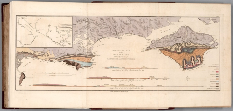
Author
[Englefield, Henry Charles, Sir Bart., 1752-1822, Webster, Thomas]
Full Title
Geological map of the Isle of Wight and the adjacent parts of Hampshire and Dorsetshire. T. Webster delint. J. Walker, Sculpt. London: Published by Payne and Foss. 1815. (to accompany) A description of principal picturesque beauties, antiquities and geological phoenomena of the isle of Wight … 1816.
List No
13337.073
Note
Hand colored geologic folded map, with insets: Southampton to Portsmouth; 3 Geological sections. Included color coded reference to geological formations and compass rose.
Author
Society for the Diffusion of Useful Knowledge (Great Britain)
Full Title
Geological Map of England and Wales.
List No
10911.012
Author
[Knipe, James Alexander , Walker, John, Walker, Charles]
Full Title
Geological Map of England and Wales showing also the Inland navigation by means of Rivers and Canals with their elevation in feet above the sea together with the Rail Roads & Principal Roads by J & C Walker.
List No
10535.002
Note
Map shows mineral types occurring across England, Wales, and southern and central Scotland. Relief shown by hachures. Includes geological and mineralogical sections from Lands End and from the St. George's Channel to the German Ocean.
Author
Greenough, George Bellas, (1778-1855)
Full Title
A Geological Map of England and Wales reduced by permission from the map in 6 sheets published by the Geological Society.
List No
10516.002
Note
Reduced from the first edition of Greenough's important large six sheet map published in 1819 in response to William Smith's pioneering Geological map of England and Wales published in 1815. See our copies of the Greenough 1839 second edition (10496.000) and the 1865 final thrid edition (10491.000).
Author
Greenough, George Bellas, (1778-1855)
Full Title
(Covers to) A Physical and Geological Map of England and Wales By G.B. Greenough Esq. F.R.S. (on the basis of the original Map of William Smith 1815) Revised and Improved under the Superintendence of a Committee of the Geological Society of London, from the maps of the Geological Survey of Great Britain, 1836-63 and the Maps and Documents contributed by Sir R. I. Murchison, Professor Phillips, Joseph Prestwich, R. Godwin Austen, and others. July 1865.
List No
10491.001
Note
Greenough first published this map in 1820, then a second edition in 1839 (see our 10496.000), and this final third posthumous edition in 1865. Greenough drew heavily on William Smith's Geological map of England and Wales but did not credit him until the third edition. There are several differences between the Greenough and Smith maps: Greenough delineates the topography and Smith does not, and Greenough's scale is 6 miles to the inch vs Smith at 5 miles to the inch. There were also differences underlying the geology of both maps. Greenough made significant revisions to the second edition and to this final third edition. Following the publication of the first 1820 edition, there was a continuing dispute between Greenough and Smith as to Greenough's uncredited use of Smith's map.
Author
Greenough, George Bellas, (1778-1855)
Full Title
N.E. Sheet. A Physical and Geological Map of England and Wales By G.B. Greenough Esq. F.R.S. (on the basis of the original Map of William Smith 1815) Revised and Improved under the Superintendence of a Committee of the Geological Society of London, from the maps of the Geological Survey of Great Britain, 1836-63 and the Maps and Documents contributed by Sir R. I. Murchison, Professor Phillips, Joseph Prestwich, R. Godwin Austen, and others. July 1865.
List No
10491.002
Note
Greenough first published this map in 1820, then a second edition in 1839 (see our 10496.000), and this final third posthumous edition in 1865. Greenough drew heavily on William Smith's Geological map of England and Wales but did not credit him until the third edition. There are several differences between the Greenough and Smith maps: Greenough delineates the topography and Smith does not, and Greenough's scale is 6 miles to the inch vs Smith at 5 miles to the inch. There were also differences underlying the geology of both maps. Greenough made significant revisions to the second edition and to this final third edition. Following the publication of the first 1820 edition, there was a continuing dispute between Greenough and Smith as to Greenough's uncredited use of Smith's map.
Author
Greenough, George Bellas, (1778-1855)
Full Title
S.E. Sheet. A Physical and Geological Map of England and Wales By G.B. Greenough Esq. F.R.S. (on the basis of the original Map of William Smith 1815) Revised and Improved under the Superintendence of a Committee of the Geological Society of London, from the maps of the Geological Survey of Great Britain, 1836-63 and the Maps and Documents contributed by Sir R. I. Murchison, Professor Phillips, Joseph Prestwich, R. Godwin Austen, and others. July 1865.
List No
10491.005
Note
Greenough first published this map in 1820, then a second edition in 1839 (see our 10496.000), and this final third posthumous edition in 1865. Greenough drew heavily on William Smith's Geological map of England and Wales but did not credit him until the third edition. There are several differences between the Greenough and Smith maps: Greenough delineates the topography and Smith does not, and Greenough's scale is 6 miles to the inch vs Smith at 5 miles to the inch. There were also differences underlying the geology of both maps. Greenough made significant revisions to the second edition and to this final third edition. Following the publication of the first 1820 edition, there was a continuing dispute between Greenough and Smith as to Greenough's uncredited use of Smith's map.
Author
Greenough, George Bellas, (1778-1855)
Full Title
(Composite map of) N.E.,N.W.,S.W.,S.E. Sheets. A Physical and Geological Map of England and Wales By G.B. Greenough Esq. F.R.S. (on the basis of the original Map of William Smith 1815) Revised and Improved under the Superintendence of a Committee of the Geological Society of London, from the maps of the Geological Survey of Great Britain, 1836-63 and the Maps and Documents contributed by Sir R. I. Murchison, Professor Phillips, Joseph Prestwich, R. Godwin Austen, and others. July 1865.
List No
10491.006
Note
Greenough first published this map in 1820, then a second edition in 1839 (see our 10496.000), and this final third posthumous edition in 1865. Greenough drew heavily on William Smith's Geological map of England and Wales but did not credit him until the third edition. There are several differences between the Greenough and Smith maps: Greenough delineates the topography and Smith does not, and Greenough's scale is 6 miles to the inch vs Smith at 5 miles to the inch. There were also differences underlying the geology of both maps. Greenough made significant revisions to the second edition and to this final third edition. Following the publication of the first 1820 edition, there was a continuing dispute between Greenough and Smith as to Greenough's uncredited use of Smith's map.
Author
Greenough, George Bellas, (1778-1855)
Full Title
(Covers to) A Physical and Geological Map of England and Wales By G.B. Greenough Esq. President of the Geological Society of London. At its Establishment and at subsequent periods: President of the Royal Geographical Society of London &c. First Edition No. 1st 1819. Second Edition Novr. 1st 1839.
List No
10496.001
Note
Greenough first published this map in 1820, then this second edition in 1839, and a final third posthumous edition in 1865. Greenough drew heavily on William Smith's Geological map of England and Wales but did not credit him until the third edition. There are several differences between the Greenough and Smith maps: Greenough delineates the topography and Smith does not, and Greenough's scale is 6 miles to the inch vs Smith at 5 miles to the inch. There were also differences underlying the geology of both maps. Greenough made significant revisions to this second edition and to the final third edition. Following the publication of the first 1820 edition, there was a continuing dispute between Greenough and Smith as to Greenough's uncredited use of Smith's map. The N.E. sheet is from a different copy as is the Index of Colours which was both pasted on the map in some copies and issued separately in others - both are present here. Although it appears that the index of colors that is pasted onto the W. Sheet of this copy is an early version of the index of colors that appears on the 1865 third edition. It does not actually represent the colors used on the map so may have been added afterwards, incorrectly. The separate sheet Index of Colours is the correct index for colors in this second edition.
Author
Greenough, George Bellas, (1778-1855)
Full Title
N.E. Sheet. A Physical and Geological Map of England and Wales By G.B. Greenough Esq. President of the Geological Society of London. At its Establishment and at subsequent periods: President of the Royal Geographical Society of London &c. First Edition No. 1st 1819. Second Edition Novr. 1st 1839.
List No
10496.002
Note
Greenough first published this map in 1820, then this second edition in 1839, and a final third posthumous edition in 1865. Greenough drew heavily on William Smith's Geological map of England and Wales but did not credit him until the third edition. There are several differences between the Greenough and Smith maps: Greenough delineates the topography and Smith does not, and Greenough's scale is 6 miles to the inch vs Smith at 5 miles to the inch. There were also differences underlying the geology of both maps. Greenough made significant revisions to this second edition and to the final third edition. Following the publication of the first 1820 edition, there was a continuing dispute between Greenough and Smith as to Greenough's uncredited use of Smith's map. The N.E. sheet is from a different copy as is the Index of Colours which was both pasted on the map in some copies and issued separately in others - both are present here. Although it appears that the index of colors that is pasted onto the W. Sheet of this copy is an early version of the index of colors that appears on the 1865 third edition. It does not actually represent the colors used on the map so may have been added afterwards, incorrectly. The separate sheet Index of Colours is the correct index for colors in this second edition.
Author
Greenough, George Bellas, (1778-1855)
Full Title
E. Sheet. A Physical and Geological Map of England and Wales By G.B. Greenough Esq. President of the Geological Society of London. At its Establishment and at subsequent periods: President of the Royal Geographical Society of London &c. First Edition No. 1st 1819. Second Edition Novr. 1st 1839.
List No
10496.004
Note
Greenough first published this map in 1820, then this second edition in 1839, and a final third posthumous edition in 1865. Greenough drew heavily on William Smith's Geological map of England and Wales but did not credit him until the third edition. There are several differences between the Greenough and Smith maps: Greenough delineates the topography and Smith does not, and Greenough's scale is 6 miles to the inch vs Smith at 5 miles to the inch. There were also differences underlying the geology of both maps. Greenough made significant revisions to this second edition and to the final third edition. Following the publication of the first 1820 edition, there was a continuing dispute between Greenough and Smith as to Greenough's uncredited use of Smith's map. The N.E. sheet is from a different copy as is the Index of Colours which was both pasted on the map in some copies and issued separately in others - both are present here. Although it appears that the index of colors that is pasted onto the W. Sheet of this copy is an early version of the index of colors that appears on the 1865 third edition. It does not actually represent the colors used on the map so may have been added afterwards, incorrectly. The separate sheet Index of Colours is the correct index for colors in this second edition.
Author
Greenough, George Bellas, (1778-1855)
Full Title
(Composite map of) A Physical and Geological Map of England and Wales By G.B. Greenough Esq. President of the Geological Society of London. At its Establishment and at subsequent periods: President of the Royal Geographical Society of London &c. First Edition No. 1st 1819. Second Edition Novr. 1st 1839.
List No
10496.009
Note
Greenough first published this map in 1820, then this second edition in 1839, and a final third posthumous edition in 1865. Greenough drew heavily on William Smith's Geological map of England and Wales but did not credit him until the third edition. There are several differences between the Greenough and Smith maps: Greenough delineates the topography and Smith does not, and Greenough's scale is 6 miles to the inch vs Smith at 5 miles to the inch. There were also differences underlying the geology of both maps. Greenough made significant revisions to this second edition and to the final third edition. Following the publication of the first 1820 edition, there was a continuing dispute between Greenough and Smith as to Greenough's uncredited use of Smith's map. The N.E. sheet is from a different copy as is the Index of Colours which was both pasted on the map in some copies and issued separately in others - both are present here. Although it appears that the index of colors that is pasted onto the W. Sheet of this copy is an early version of the index of colors that appears on the 1865 third edition. It does not actually represent the colors used on the map so may have been added afterwards, incorrectly. The separate sheet Index of Colours is the correct index for colors in this second edition.
Author
Greenough, George Bellas, (1778-1855)
Full Title
(Composite map of) A Physical and Geological Map of England and Wales By G.B. Greenough Esq. President of the Geological Society of London. At its Establishment and at subsequent periods: President of the Royal Geographical Society of London &c. First Edition No. 1st 1819. Second Edition Novr. 1st 1839.
List No
10496.010
Note
Note: This composite image has added the original separately printed Index of Colours below the title on the E. Sheet. Greenough first published this map in 1820, then this second edition in 1839, and a final third posthumous edition in 1865. Greenough drew heavily on William Smith's Geological map of England and Wales but did not credit him until the third edition. There are several differences between the Greenough and Smith maps: Greenough delineates the topography and Smith does not, and Greenough's scale is 6 miles to the inch vs Smith at 5 miles to the inch. There were also differences underlying the geology of both maps. Greenough made significant revisions to this second edition and to the final third edition. Following the publication of the first 1820 edition, there was a continuing dispute between Greenough and Smith as to Greenough's uncredited use of Smith's map. The N.E. sheet is from a different copy as is the Index of Colours which was both pasted on the map in some copies and issued separately in others - both are present here. Although it appears that the index of colors that is pasted onto the W. Sheet of this copy is an early version of the index of colors that appears on the 1865 third edition. It does not actually represent the colors used on the map so may have been added afterwards, incorrectly. The separate sheet Index of Colours is the correct index for colors in this second edition.
Author
[Ordnance Survey Office, Geikie, Archibald]
Full Title
(Composite of) Sheets 2 - 15. Ordnance Survey of England and Wales.
List No
8742.017
Author
[Geological Survey of Great Britain and Ireland, Great Britain, Ordnance Survey Office]
Full Title
44. Cheltenham.
List No
6913.076
Note
Paper.
Author
Arrowsmith, John
Full Title
The inland navigation, rail roads, geology and minerals of England & Wales, by J. Arrowsmith. London, pubd. 15 Feby. 1834 by J. Arrowsmith, 35 Essex Street, Strand.
List No
0036.005
Note
Engraved map. Geologic units hand colored. Relief shown by hachures. Includes explanation and relief profiles.
Author
[Forbes, Edward, 1815-1854, Johnston, Alexander Keith, 1804-1871]
Full Title
(Covers to) & Palaeontological Map Of The British Islands. By A.K. Johnston, F.R.G.S. From the Sketches & Notes of Professor Edward Forbes F.R.S. Of Kings College London & Of The Government School Of Mines. President Of The Geological Society. Physical Atlas. Geology No. 5. Plate 5. William Blackwood & Sons, Edinburgh & London. Engraved by W. & A.K. Johnston.
List No
0371A
Note
Separately issued plate from the Physical Atlas. Printed in full color. Map is dissected into 12 sections, edged in red cloth and mounted on linen. Folds into black leather covers 28x23.5 with "Palaeontological Map Of The British Islands" stamped in gilt.
Author
[Forbes, Edward, 1815-1854, Johnston, Alexander Keith, 1804-1871]
Full Title
Geological & Palaeontological Map Of The British Islands. By A.K. Johnston, F.R.G.S. From the Sketches & Notes of Professor Edward Forbes F.R.S. Of Kings College London & Of The Government School Of Mines. President Of The Geological Society. Physical Atlas. Geology No. 5. Plate 5. William Blackwood & Sons, Edinburgh & London. Engraved by W. & A.K. Johnston.
List No
0371.001
Note
Separately issued plate from the Physical Atlas. Printed in full color. Map is dissected into 12 sections, edged in red cloth and mounted on linen. Folds into black leather covers 28x23.5 with "Palaeontological Map Of The British Islands" stamped in gilt.
Author
Forbes, Edward, 1815-1854
Full Title
On the Geology and Paleontology of the British Isles. I. Table of Fossiliferous Formations in the British Islands.
List No
0372R
Author
Forbes, Edward, 1815-1854
Full Title
On the Geology and Paleontology of the British Isles. I. Table of Fossiliferous Formations in the British Islands. (continued) II. Distribution of Organized Beings in Time.
List No
0372S
Author
Forbes, Edward, 1815-1854
Full Title
On the Geology and Paleontology of the British Isles. II. Distribution of Organized Beings in Time. (continued)
List No
0372T
Author
[Forbes, Edward, 1815-1854, Johnston, Alexander Keith, 1804-1871]
Full Title
Palaeontological map (British Islands. By A.K. Johnston, F.R.G.S. From the sketches & notes of Professor Edward Forbes, F.R.S. of Kings College London & of the Government School of Mines, President of the Geological Society). Engraved by W. & A.K. Johnston. William Blackwood & Sons, Edinburgh & London. 1st March 1854, (1856)
List No
0372.006
Note
Col. lithographed map. Southern half of "Geological & palaeontological map of the British Islands." Covers Wales and most of England and Ireland. Shows 25 geologic units. Includes notes, tables and illustrations: Types of groups of Ammonites ... after Von Buch & D'Orbigny." "Geology no. 6."
Author
Forbes, Edward, 1815-1854
Full Title
On the Geology and Paleontology of the British Isles. II. Distribution of Organized Beings in Time.
List No
0372U
Author
Forbes, Edward, 1815-1854
Full Title
On the Geology and Paleontology of the British Isles. II. Distribution of Organized Beings in Time. (continued)
List No
0372V
Author
Forbes, Edward, 1815-1854
Full Title
On the Geology and Paleontology of the British Isles. II. Distribution of Organized Beings in Time. (continued)
List No
0372W
Author
Malte-Brun, Conrad, 1775-1826
Full Title
Carte Physique et Mineralogique des Isles Britanniques presentus les Bassins, les principales Montagnes, les Cours d'Eau, les Roches, et les substances Minerales. 1832. Grave par Thierry.
List No
0458.024
Note
Engraved map. Geologic units listed and described in legend and depicted in full color. Major relief depicted with hachures. Rivers, lakes, islands, and basins shown. Includes 2 scales.
Author
[Reynolds, James, Emslie, John]
Full Title
Geological map of England. London. Published by James Reynolds 174 Strand. Decr. 13th. 1849. (inset views) Slate quarries. (with) Coal mining. (with) The Needles Isle of Wight. (with cross section) Section of the Line A-B. (to accompany) Geological Diagrams.
List No
0848.012
Note
Hand color engraved map. Dhowing colour-coded areas of rock formations in England. with note: "Primary series colored blue, Secondary series green, Tertiary series yellow". Includes reference identifying the geologic rock formation, text, and cross section. Chart is one of a series of 44 educational charts drawn and engraved by John Emslie. The first geological map of Britain, indeed of any country in the world, was published by William Smith (1769-1839) in 1815.
Author
[Murchison, Roderick Impey, Sir, 1792-1871, Society for the Diffusion of Useful Knowledge (Great Britain)]
Full Title
Geological map of England and Wales. Published under the superintendence of the Society for the Diffusion of Useful Knowledge. 1843. Arranged by Roderick Impey Murchison ... S.P. Woodward del. Col(oure)d. by T. Malby. J. & C. Walker sculpt. Published by Chapman & Hall 186 Strand Decr. 15th. 1843. (1844)
List No
0890.012
Note
Engraved map. Geologic units hand col. Also shows railroads, canals, navigable rivers and dip of strata.
Author
[Stanford, Edward, Woodward, H.B.]
Full Title
Geological Map of the British Isles by Edward Best. Edward Best, Geological Survey.(in set) Orkney and Shetland Islands.
List No
0949.018
Note
Shows 27 geologic units.
Author
[Stanford, Edward, Woodward, H.B.]
Full Title
A County Map of the British Isles. (inset) Orkney and Shetland Islands.
List No
0949.019
Note
Shows 27 geologic units.
Author
Greenough, George Bellas, (1778-1855)
Full Title
N.W. Sheet. A Physical and Geological Map of England and Wales By G.B. Greenough Esq. F.R.S. (on the basis of the original Map of William Smith 1815) Revised and Improved under the Superintendence of a Committee of the Geological Society of London, from the maps of the Geological Survey of Great Britain, 1836-63 and the Maps and Documents contributed by Sir R. I. Murchison, Professor Phillips, Joseph Prestwich, R. Godwin Austen, and others. July 1865.
List No
10491.003
Note
Greenough first published this map in 1820, then a second edition in 1839 (see our 10496.000), and this final third posthumous edition in 1865. Greenough drew heavily on William Smith's Geological map of England and Wales but did not credit him until the third edition. There are several differences between the Greenough and Smith maps: Greenough delineates the topography and Smith does not, and Greenough's scale is 6 miles to the inch vs Smith at 5 miles to the inch. There were also differences underlying the geology of both maps. Greenough made significant revisions to the second edition and to this final third edition. Following the publication of the first 1820 edition, there was a continuing dispute between Greenough and Smith as to Greenough's uncredited use of Smith's map.
Author
Greenough, George Bellas, (1778-1855)
Full Title
S.W. Sheet. A Physical and Geological Map of England and Wales By G.B. Greenough Esq. F.R.S. (on the basis of the original Map of William Smith 1815) Revised and Improved under the Superintendence of a Committee of the Geological Society of London, from the maps of the Geological Survey of Great Britain, 1836-63 and the Maps and Documents contributed by Sir R. I. Murchison, Professor Phillips, Joseph Prestwich, R. Godwin Austen, and others. July 1865.
List No
10491.004
Note
Greenough first published this map in 1820, then a second edition in 1839 (see our 10496.000), and this final third posthumous edition in 1865. Greenough drew heavily on William Smith's Geological map of England and Wales but did not credit him until the third edition. There are several differences between the Greenough and Smith maps: Greenough delineates the topography and Smith does not, and Greenough's scale is 6 miles to the inch vs Smith at 5 miles to the inch. There were also differences underlying the geology of both maps. Greenough made significant revisions to the second edition and to this final third edition. Following the publication of the first 1820 edition, there was a continuing dispute between Greenough and Smith as to Greenough's uncredited use of Smith's map.
Author
Greenough, George Bellas, (1778-1855)
Full Title
N.W. Sheet. A Physical and Geological Map of England and Wales By G.B. Greenough Esq. President of the Geological Society of London. At its Establishment and at subsequent periods: President of the Royal Geographical Society of London &c. First Edition No. 1st 1819. Second Edition Novr. 1st 1839.
List No
10496.003
Note
Greenough first published this map in 1820, then this second edition in 1839, and a final third posthumous edition in 1865. Greenough drew heavily on William Smith's Geological map of England and Wales but did not credit him until the third edition. There are several differences between the Greenough and Smith maps: Greenough delineates the topography and Smith does not, and Greenough's scale is 6 miles to the inch vs Smith at 5 miles to the inch. There were also differences underlying the geology of both maps. Greenough made significant revisions to this second edition and to the final third edition. Following the publication of the first 1820 edition, there was a continuing dispute between Greenough and Smith as to Greenough's uncredited use of Smith's map. The N.E. sheet is from a different copy as is the Index of Colours which was both pasted on the map in some copies and issued separately in others - both are present here. Although it appears that the index of colors that is pasted onto the W. Sheet of this copy is an early version of the index of colors that appears on the 1865 third edition. It does not actually represent the colors used on the map so may have been added afterwards, incorrectly. The separate sheet Index of Colours is the correct index for colors in this second edition.
Author
Greenough, George Bellas, (1778-1855)
Full Title
W. Sheet. A Physical and Geological Map of England and Wales By G.B. Greenough Esq. President of the Geological Society of London. At its Establishment and at subsequent periods: President of the Royal Geographical Society of London &c. First Edition No. 1st 1819. Second Edition Novr. 1st 1839.
List No
10496.005
Note
Greenough first published this map in 1820, then this second edition in 1839, and a final third posthumous edition in 1865. Greenough drew heavily on William Smith's Geological map of England and Wales but did not credit him until the third edition. There are several differences between the Greenough and Smith maps: Greenough delineates the topography and Smith does not, and Greenough's scale is 6 miles to the inch vs Smith at 5 miles to the inch. There were also differences underlying the geology of both maps. Greenough made significant revisions to this second edition and to the final third edition. Following the publication of the first 1820 edition, there was a continuing dispute between Greenough and Smith as to Greenough's uncredited use of Smith's map. The N.E. sheet is from a different copy as is the Index of Colours which was both pasted on the map in some copies and issued separately in others - both are present here. Although it appears that the index of colors that is pasted onto the W. Sheet of this copy is an early version of the index of colors that appears on the 1865 third edition. It does not actually represent the colors used on the map so may have been added afterwards, incorrectly. The separate sheet Index of Colours is the correct index for colors in this second edition.
Author
Greenough, George Bellas, (1778-1855)
Full Title
S.E. Sheet. A Physical and Geological Map of England and Wales By G.B. Greenough Esq. President of the Geological Society of London. At its Establishment and at subsequent periods: President of the Royal Geographical Society of London &c. First Edition No. 1st 1819. Second Edition Novr. 1st 1839.
List No
10496.006
Note
Greenough first published this map in 1820, then this second edition in 1839, and a final third posthumous edition in 1865. Greenough drew heavily on William Smith's Geological map of England and Wales but did not credit him until the third edition. There are several differences between the Greenough and Smith maps: Greenough delineates the topography and Smith does not, and Greenough's scale is 6 miles to the inch vs Smith at 5 miles to the inch. There were also differences underlying the geology of both maps. Greenough made significant revisions to this second edition and to the final third edition. Following the publication of the first 1820 edition, there was a continuing dispute between Greenough and Smith as to Greenough's uncredited use of Smith's map. The N.E. sheet is from a different copy as is the Index of Colours which was both pasted on the map in some copies and issued separately in others - both are present here. Although it appears that the index of colors that is pasted onto the W. Sheet of this copy is an early version of the index of colors that appears on the 1865 third edition. It does not actually represent the colors used on the map so may have been added afterwards, incorrectly. The separate sheet Index of Colours is the correct index for colors in this second edition.
Author
Greenough, George Bellas, (1778-1855)
Full Title
S.W. Sheet. A Physical and Geological Map of England and Wales By G.B. Greenough Esq. President of the Geological Society of London. At its Establishment and at subsequent periods: President of the Royal Geographical Society of London &c. First Edition No. 1st 1819. Second Edition Novr. 1st 1839.
List No
10496.007
Note
Greenough first published this map in 1820, then this second edition in 1839, and a final third posthumous edition in 1865. Greenough drew heavily on William Smith's Geological map of England and Wales but did not credit him until the third edition. There are several differences between the Greenough and Smith maps: Greenough delineates the topography and Smith does not, and Greenough's scale is 6 miles to the inch vs Smith at 5 miles to the inch. There were also differences underlying the geology of both maps. Greenough made significant revisions to this second edition and to the final third edition. Following the publication of the first 1820 edition, there was a continuing dispute between Greenough and Smith as to Greenough's uncredited use of Smith's map. The N.E. sheet is from a different copy as is the Index of Colours which was both pasted on the map in some copies and issued separately in others - both are present here. Although it appears that the index of colors that is pasted onto the W. Sheet of this copy is an early version of the index of colors that appears on the 1865 third edition. It does not actually represent the colors used on the map so may have been added afterwards, incorrectly. The separate sheet Index of Colours is the correct index for colors in this second edition.
Author
Greenough, George Bellas, (1778-1855)
Full Title
Index of Colours. A Physical and Geological Map of England and Wales By G.B. Greenough Esq. President of the Geological Society of London. At its Establishment and at subsequent periods: President of the Royal Geographical Society of London &c. First Edition No. 1st 1819. Second Edition Novr. 1st 1839.
List No
10496.008
Note
Greenough first published this map in 1820, then this second edition in 1839, and a final third posthumous edition in 1865. Greenough drew heavily on William Smith's Geological map of England and Wales but did not credit him until the third edition. There are several differences between the Greenough and Smith maps: Greenough delineates the topography and Smith does not, and Greenough's scale is 6 miles to the inch vs Smith at 5 miles to the inch. There were also differences underlying the geology of both maps. Greenough made significant revisions to this second edition and to the final third edition. Following the publication of the first 1820 edition, there was a continuing dispute between Greenough and Smith as to Greenough's uncredited use of Smith's map. The N.E. sheet is from a different copy as is the Index of Colours which was both pasted on the map in some copies and issued separately in others - both are present here. Although it appears that the index of colors that is pasted onto the W. Sheet of this copy is an early version of the index of colors that appears on the 1865 third edition. It does not actually represent the colors used on the map so may have been added afterwards, incorrectly. The separate sheet Index of Colours is the correct index for colors in this second edition.
Author
Greenough, George Bellas, (1778-1855)
Full Title
(Covers to) A Geological Map of England and Wales reduced by permission from the map in 6 sheets published by the Geological Society.
List No
10516.001
Note
Reduced from the first edition of Greenough's important large six sheet map published in 1819 in response to William Smith's pioneering Geological map of England and Wales published in 1815. See our copies of the Greenough 1839 second edition (10496.000) and the 1865 final thrid edition (10491.000).
Author
Wyld, James, 1812-1887
Full Title
(Covers to) Map Of The Superficial Geology Of The British Isles, With The Physical And Topographical Features, The Line Of Railways, their Primary and Intermediate Stations, The General Internal Communication Of The Countries, and the Steam Packet Routes, with the Distance from Port to Port. Compiled from Ordnance Surveys, and other Authentic information, By James Wyld, Geographer to the Queen, Charing Cross East. London. Published by Jas. Wyld, Geographer To The Queen & H.R.H. Prince Albert, Charing Cross East. (inset) Shetland Islands.
List No
1245A
Note
Outline color. Map is edged and backed with linen and dissected into 32 sections. Folds with a paste down label on the end sheet reading "Islas Britanicas" in ms, and "Longuet, Sucer. de Simonneau, Graveur-Editeur de Cartes geographiques. Tient aussi toutes les Cartes publiees par le Depot de la Guerre. Paris, Rue De La Paix No. 8 ..." printed in black. Map slips into a new blue cloth covered slip case with "Geology Of The British Isles J. Wyld 1856" stamped in gilt on the spine.
Author
Wyld, James, 1812-1887
Full Title
Map Of The Superficial Geology Of The British Isles, With The Physical And Topographical Features, The Line Of Railways, their Primary and Intermediate Stations, The General Internal Communication Of The Countries, and the Steam Packet Routes, with the Distance from Port to Port. Compiled from Ordnance Surveys, and other Authentic information, By James Wyld, Geographer to the Queen, Charing Cross East. London. Published by Jas. Wyld, Geographer To The Queen & H.R.H. Prince Albert, Charing Cross East. (inset) Shetland Islands.
List No
1245.001
Note
Outline color. Map is edged and backed with linen and dissected into 32 sections. Folds with a paste down label on the end sheet reading "Islas Britanicas" in ms, and "Longuet, Sucer. de Simonneau, Graveur-Editeur de Cartes geographiques. Tient aussi toutes les Cartes publiees par le Depot de la Guerre. Paris, Rue De La Paix No. 8 ..." printed in black. Map slips into a new blue cloth covered slip case with "Geology Of The British Isles J. Wyld 1856" stamped in gilt on the spine.
Author
[Reynolds, James, Emslie, John]
Full Title
Geological map of England. Drawn & Engraved by John Emslie. London, Published by James Reynolds, 174, Strand. Decr. 13th. 1849. (to accompany) Reynolds introduction to natural philosophy. (inset views) Slate quarries. (with) Coal mining. (with cross sections) Section of the London Base. (with) Section of the Line A-B.
List No
13033.026
Note
Hand colored engraved geological map. Shows color-coded areas of rock formations in England. Includes explanatory text and reference to various rocks.
Author
Strahan, A.
Full Title
Coal Resources of the World. England and Wales. Map No. 29. Map Showing Visible and Proved Coal Fields of England and Wales prepared under the direction of A. Strahan at the Geological Survey of Great Britain. London 1912.
List No
2249.031
Note
Coal fields in color.
Author
Society for the Diffusion of Useful Knowledge (Great Britain)
Full Title
Geological Map of England and Wales.
List No
2326.010
Author
Arrowsmith, John
Full Title
The Inland Navigation, Rail Roads, Geology and Minerals of England & Wales, By J. Arrowsmith. (Map) 5. London, Pubd. 15 Feby. 1842, by J. Arrowsmith, 10 Soho Square.
List No
4613.005
Note
Note on map states: "For the list of the several Geological Groups, and Divisions in this map, I have been principally indebted to the splendid Geological Map of England and Wales, by G.B. Greenough Esqr. F.G.S." In full color. Legend shows the geological groups on the map. Four sections of the line of navigation included.
Author
[Best, Edward, Edward Stanford Ltd., Stanford, Edward]
Full Title
Geological map of the British Isles by Edward Best. Edward Best, Geological Survey. London atlas series. Stanford's Geographical Establishment. London : Edward Stanford, 12, 13 & 14 Long Acre, W.C. (1901)
List No
5075.010
Note
Full color. Shows 27 geologic units. Includes inset of the Shetland and Orkney islands. "VIII.87, XI.93."
Author
[Bristow, Henry W., Letts, Son & Co.]
Full Title
Geological map of England & Wales, with leading railways by Henry W. Bristow, F.R.S., F.G.S., Director of the Geological Survey of England and Wales. Letts's popular atlas. Letts, Son & Co. Limited, London. (1883)
List No
5371.007
Note
Colored map. Includes descriptive notes and explanation.
Author
Letts, Son & Co.
Full Title
Geological map of the environs of London. Letts's popular atlas. Letts, Son & Co. Limited, London. (1883)
List No
5371.015
Note
Colored map. Relief shown by hachures. Shows railroads, radial distances from Charing Cross, explanation, etc. "This map can be purchased separately, mounted on a board and varnished for 2/6, or backed with the "Orographical Map" for 3/6.
Author
[Andree, Richard, Times (London, England)]
Full Title
England and Wales Geological map. (Published at the office of "The Times," London, 1900).
List No
6809.017
Note
Color map on 2 sheets. Shows geological formations. settlements, counties, railroads, canals, etc. Prime meridian is Greenwich.
Author
Loader, T. B.
Full Title
Under the patronage of His Majesty, T.B. Loader's scientific and commercial map of England and Wales in which are delineated the canals, rail-roads, & navigable rivers : the extent of the navigation of each river, with the elevations of the canals, together with the geology, and principal situations of the mineral productions. 1834. Published by T.B. Loader, 31 Bedford, St. Covent Garden. Mounted & colored by G. Cross, 98 Dean St. Soho.
List No
6887.000
Note
Color map, dissected and mounted on cloth ; 128 x 103, folded to 23 x 14. Shows rivers, canals, railroads, lighthouses, and roads. Includes geological references and ores, and explanation.
Author
[Geological Survey of Great Britain and Ireland, Great Britain, Ordnance Survey Office]
Full Title
1. Brentwood, NE Quad.
List No
6913.001
Note
Paper on linen.
Author
[Geological Survey of Great Britain and Ireland, Great Britain, Ordnance Survey Office]
Full Title
1. Brentwood, NW Quad.
List No
6913.002
Note
Paper on linen.
Author
[Geological Survey of Great Britain and Ireland, Great Britain, Ordnance Survey Office]
Full Title
1. Brentwood, SE Quad.
List No
6913.003
Note
Paper on linen.
Author
[Geological Survey of Great Britain and Ireland, Great Britain, Ordnance Survey Office]
Full Title
1. Brentwood, SW Quad.
List No
6913.004
Note
Paper.
Author
[Geological Survey of Great Britain and Ireland, Great Britain, Ordnance Survey Office]
Full Title
2. Sheerness.
List No
6913.005
Note
Paper.
Author
[Geological Survey of Great Britain and Ireland, Great Britain, Ordnance Survey Office]
Full Title
3. Canterbury.
List No
6913.007
Note
Folded. Map cut into 28 panels and mounted on linen. Trimmed of most of border and all of margin. Marginalia was clipped and pasted onto map.
Author
[Geological Survey of Great Britain and Ireland, Great Britain, Ordnance Survey Office]
Full Title
4. Denge Ness.
List No
6913.009
Note
Paper.
Author
[Geological Survey of Great Britain and Ireland, Great Britain, Ordnance Survey Office]
Full Title
5. Hastings.
List No
6913.011
Note
Folded. Map cut into 12 panels mounted on linen. Forms a rectangle with a small extended tab at the bottom.
Author
[Geological Survey of Great Britain and Ireland, Great Britain, Ordnance Survey Office]
Full Title
6. Maidstone.
List No
6913.013
Note
Papeer on linen.
Author
[Geological Survey of Great Britain and Ireland, Great Britain, Ordnance Survey Office]
Full Title
7. London.
List No
6913.014
Note
Paper.
Author
[Geological Survey of Great Britain and Ireland, Great Britain, Ordnance Survey Office]
Full Title
8. Dorking.
List No
6913.016
Note
Folded. Map cut into 32 panels and mounted on linen.
Author
[Geological Survey of Great Britain and Ireland, Great Britain, Ordnance Survey Office]
Full Title
9. Brighton.
List No
6913.018
Note
Cut into 4 panels and mounted on linen.
Author
[Geological Survey of Great Britain and Ireland, Great Britain, Ordnance Survey Office]
Full Title
10. Isle of Wight.
List No
6913.020
Note
Paper.
Author
[Geological Survey of Great Britain and Ireland, Great Britain, Ordnance Survey Office]
Full Title
11. Winchester.
List No
6913.021
Note
Paper.
Author
[Geological Survey of Great Britain and Ireland, Great Britain, Ordnance Survey Office]
Full Title
12. Basingstoke.
List No
6913.023
Note
Folded. Map cut into 28 panels and mounted on linen.
Author
[Geological Survey of Great Britain and Ireland, Great Britain, Ordnance Survey Office]
Full Title
13. Oxford.
List No
6913.025
Note
Paper.
Author
[Geological Survey of Great Britain and Ireland, Great Britain, Ordnance Survey Office]
Full Title
14. Devizes.
List No
6913.026
Note
Cut into 4 panels, mounted on linen.
Author
[Geological Survey of Great Britain and Ireland, Great Britain, Ordnance Survey Office]
Full Title
15. Salisbury.
List No
6913.028
Note
Cut into 4 panels, mounted on linen.
Author
[Geological Survey of Great Britain and Ireland, Great Britain, Ordnance Survey Office]
Full Title
16. Poole.
List No
6913.030
Note
Paper.
Author
[Geological Survey of Great Britain and Ireland, Great Britain, Ordnance Survey Office]
Full Title
17. Dorchester.
List No
6913.031
Note
Paper on linen.
Author
[Geological Survey of Great Britain and Ireland, Great Britain, Ordnance Survey Office]
Full Title
18. Sherborne.
List No
6913.033
Note
Folded. Map cut into 15 panels mounted on linen.
Author
[Geological Survey of Great Britain and Ireland, Great Britain, Ordnance Survey Office]
Full Title
19. Bath & Wells.
List No
6913.035
Note
Cut into 4 panels, mounted on linen.
Author
[Geological Survey of Great Britain and Ireland, Great Britain, Ordnance Survey Office]
Full Title
20. Bridgewater.
List No
6913.037
Note
Paper.
Author
[Geological Survey of Great Britain and Ireland, Great Britain, Ordnance Survey Office]
Full Title
21. Tiverton.
List No
6913.038
Note
Date estimated. Paper.
Author
[Geological Survey of Great Britain and Ireland, Great Britain, Ordnance Survey Office]
Full Title
22. Exeter.
List No
6913.040
Note
Date estimated. Cut into 19 panels mounted on muslin. Folded. Panels omitted over the sea; panels do not form a rectangle.
Author
[Geological Survey of Great Britain and Ireland, Great Britain, Ordnance Survey Office]
Full Title
23. Dartmouth.
List No
6913.042
Note
Date estimated. Paper.
Author
[Geological Survey of Great Britain and Ireland, Great Britain, Ordnance Survey Office]
Full Title
24. Plymouth.
List No
6913.043
Note
Paper on linen.
Author
[Geological Survey of Great Britain and Ireland, Great Britain, Ordnance Survey Office]
Full Title
25. Tavistock.
List No
6913.044
Note
Paper on linen.
Author
[Geological Survey of Great Britain and Ireland, Great Britain, Ordnance Survey Office]
Full Title
26. Bideford.
List No
6913.045
Note
Paper on linen.
Author
[Geological Survey of Great Britain and Ireland, Great Britain, Ordnance Survey Office]
Full Title
27. Barnstaple.
List No
6913.046
Note
Date estimated. Paper.
Author
[Geological Survey of Great Britain and Ireland, Great Britain, Ordnance Survey Office]
Full Title
28. Lundy Island.
List No
6913.047
Note
Sheet absent in our collection; image provided by the British Geological Survey. Image contains British Geological Survey materials © NERC 2013. For more information on the Historical Geological Maps of the British Geological Survey and the uses that may be made of these images, see http://www.bgs.ac.uk/data/historicalmaps/home.html
Author
[Geological Survey of Great Britain and Ireland, Great Britain, Ordnance Survey Office]
Full Title
29. Hartland Point.
List No
6913.048
Note
Date estimated. Paper.
Author
[Geological Survey of Great Britain and Ireland, Great Britain, Ordnance Survey Office]
Full Title
30. Camelford.
List No
6913.049
Note
Paper on linen.
Author
[Geological Survey of Great Britain and Ireland, Great Britain, Ordnance Survey Office]
Full Title
31. Truro.
List No
6913.050
Note
Paper on linen.
Author
[Geological Survey of Great Britain and Ireland, Great Britain, Ordnance Survey Office]
Full Title
32. Lizard Head.
List No
6913.051
Note
Date estimated. Paper on linen,
Author
[Geological Survey of Great Britain and Ireland, Great Britain, Ordnance Survey Office]
Full Title
33. Penzance.
List No
6913.052
Note
Paper.
Author
[Geological Survey of Great Britain and Ireland, Great Britain, Ordnance Survey Office]
Full Title
34. Cirencester.
List No
6913.053
Note
Cut into 8 panels mounted on linen.
Author
[Geological Survey of Great Britain and Ireland, Great Britain, Ordnance Survey Office]
Full Title
35. Bristol.
List No
6913.056
Note
Map cut into 16 panels and mounted on linen.
Author
[Geological Survey of Great Britain and Ireland, Great Britain, Ordnance Survey Office]
Full Title
36. Cardiff.
List No
6913.058
Note
Sheet absent in our collection; image provided by the British Geological Survey. Image contains British Geological Survey materials © NERC 2013. For more information on the Historical Geological Maps of the British Geological Survey and the uses that may be made of these images, see http://www.bgs.ac.uk/data/historicalmaps/home.html
Author
[Geological Survey of Great Britain and Ireland, Great Britain, Ordnance Survey Office]
Full Title
37. Swansea.
List No
6913.060
Note
Date estimated. Map cut into 32 panels and mounted on linen.
Author
[Geological Survey of Great Britain and Ireland, Great Britain, Ordnance Survey Office]
Full Title
38. Pembroke.
List No
6913.062
Note
Paper on linen.
Author
[Geological Survey of Great Britain and Ireland, Great Britain, Ordnance Survey Office]
Full Title
39. Smalls Light.
List No
6913.063
Note
Sheet absent in our collection; image provided by the British Geological Survey. Image contains British Geological Survey materials © NERC 2013. For more information on the Historical Geological Maps of the British Geological Survey and the uses that may be made of these images, see http://www.bgs.ac.uk/data/historicalmaps/home.html
Author
[Geological Survey of Great Britain and Ireland, Great Britain, Ordnance Survey Office]
Full Title
40. Haverfordwest.
List No
6913.064
Note
Paper on linen.
Author
[Geological Survey of Great Britain and Ireland, Great Britain, Ordnance Survey Office]
Full Title
41. Caermathen.
List No
6913.065
Note
Paper on linen.
Author
[Geological Survey of Great Britain and Ireland, Great Britain, Ordnance Survey Office]
Full Title
42. Brecon, NE Quad.
List No
6913.067
Note
Date estimated. Map cut into ten panels and mounted on linen.
Author
[Geological Survey of Great Britain and Ireland, Great Britain, Ordnance Survey Office]
Full Title
42. Brechnock, Brecon, NW Quad.
List No
6913.069
Note
Paper on linen.
Author
[Geological Survey of Great Britain and Ireland, Great Britain, Ordnance Survey Office]
Full Title
42. Brecon, SE Quad.
List No
6913.070
Note
Sheet absent in our collection; image provided by the British Geological Survey. Image contains British Geological Survey materials © NERC 2013. For more information on the Historical Geological Maps of the British Geological Survey and the uses that may be made of these images, see http://www.bgs.ac.uk/data/historicalmaps/home.html
|