|
Author
[California. State Earthquake Investigation Commission, U.S. Geological Survey]
Full Title
California, Redlands quadrangle of the U.S. Geological Survey showing the San Andreas Rift. Earthquake Investigation Commission. Andrew B. Graham Co., Lithographers, Washington, D.C. (Carnegie Institution of Washington. 1908)
List No
2130.013
Note
Color. 15-minute topographic quadrangle. Relief shown by contours and spot heights. Covers portions of San Bernardino and Riverside counties.
Author
[California. State Earthquake Investigation Commission, U.S. Geological Survey]
Full Title
California, San Gorgonio quadrangle of the U.S. Geological Survey showing the San Andreas Rift and the Mission Creek Fault. Earthquake Investigation Commission. Andrew B. Graham Co., Lithographers, Washington, D.C. (Carnegie Institution of Washington. 1908)
List No
2130.014
Note
Color. 30-minute topographic quadrangle. Relief shown by contours and spot heights. Covers portions of San Bernardino and Riverside counties.
Author
[California. State Earthquake Investigation Commission, U.S. Geological Survey]
Full Title
California, San Jacinto quadrangle of the U.S. Geological Survey showing the San Andreas Rift, the Mission Creek Fault and the San Jacinto Fault. Earthquake Investigation Commission. Andrew B. Graham Co., Lithographers, Washington, D.C. (Carnegie Institution of Washington. 1908)
List No
2130.015
Note
Color. 30-minute topographic quadrangle. Relief shown by contours and spot heights. Covers portions of Riverside County.
Author
California. State Earthquake Investigation Commission
Full Title
Map of the city of Santa Rosa, Sonoma County, California showing the portions destroyed by the earthquake of April 18, 1906, and by the fire consequent thereto. Earthquake Investigation Commission. A. Hoen & Co., Baltimore. (Carnegie Institution of Washington. 1908)
List No
2130.016
Note
Relief shown by hachures. Shows buildings destroyed by earthquake and following fire.
Author
[California. State Earthquake Investigation Commission, Lawson, Andrew C., Wood, Harry O.]
Full Title
Geological map of the city of San Francisco by Andrew C. Lawson. To accompany the paper by H.O. Wood. Earthquake Investigation Commission. A. Hoen & Co. (Carnegie Institution of Washington. 1908)
List No
2130.017
Note
Color. Relief shown by contours and spot heights. Shows 10 geologic units and original shoreline. "Topography by the Coast and Geodetic Survey." For sections see map 18.
Author
[California. State Earthquake Investigation Commission, Wood, Harry O.]
Full Title
Geological profiles with corresponding intensity curves across the city of San Francisco. To accompany the paper by H.O. Wood. Earthquake Investigation Commission. A. Hoen & Co. (Carnegie Institution of Washington. 1908)
List No
2130.018
Note
Color. Six sections with legend and explanatory note. Shows 10 geologic units. Accompanies map 17.
Author
[California. State Earthquake Investigation Commission, Wood, Harry O.]
Full Title
Map of San Francisco showing distribution of apparent intensity of the earthquake shock by H.O. Wood. Earthquake Investigation Commission. A. Hoen & Co., Baltimore. (Carnegie Institution of Washington. 1908)
List No
2130.019
Note
Color. Relief shown by contours and spot heights. "Topography by the Coast and Geodetic Survey."
Author
California. State Earthquake Investigation Commission
Full Title
Map of the city of San Francisco showing the streets and the burnt area, 1906. Earthquake Investigation Commission. Britton & Rey, engravers, San Francisco. (Carnegie Institution of Washington. 1908)
List No
2130.020
Note
Color. Shows block numbers, tracts, railroads, original shoreline, etc.
Author
[California. State Earthquake Investigation Commission, U.S. Geological Survey]
Full Title
California, San Mateo quadrangle of the U.S. Geological Survey showing the distribution of apparent intensity, the known faults, and the routes examined. Earthquake Investigation Commission. A. Hoen & Co., Baltimore. (Carnegie Institution of Washington. 1908)
List No
2130.021
Note
Color. 15-minute topographic quadrangle. Relief shown by contours and spot heights. Covers portions of San Mateo and San Francisco counties. Rossi-Forel scale.
Author
[California. State Earthquake Investigation Commission, U.S. Geological Survey]
Full Title
California, Santa Cruz quadrangle of the U.S. Geological Survey showing the distribution of apparent intensity, the known faults, the routes examined and the numbered localities referred to in the text. Earthquake Investigation Commission. A. Hoen & Co., Baltimore. (Carnegie Institution of Washington. 1908)
List No
2130.022
Note
Color. 30-minute topographic quadrangle. Relief shown by contours and spot heights. Covers portions of San Mateo, Santa Clara and Santa Cruz counties. Rossi-Forel scale.
Author
California. State Earthquake Investigation Commission
Full Title
Map of California and Nevada showing the distribution of apparent intensity in the region affected by the earthquake of April 18, 1906. Drawn by M. Solem. Earthquake Investigation Commission. A. Hoen & Co., Baltimore. (Carnegie Institution of Washington. 1908)
List No
2130.023
Note
Color. Covers also parts of Oregon and Idaho. Rossi-Forel scale.
Author
California. State Earthquake Investigation Commission
Full Title
Map of the Coast Range Region of Middle California showing the distribution of earth movement on April 18, 1906 as revealed by the displacement of the triangulation stations of the Coast and Geodetic Surveyed, determined by resurvey, 1906-07. Drawn by M. Solem. Earthquake Investigation Commission. A. Hoen & Co., Baltimore. (Carnegie Institution of Washington. 1908)
List No
2130.024
Note
Color. Shows fault of 1906, movement of 1906, successive movements of 1868 and 1906, combined movements of 1868 and 1906, railroads, settlements, etc.
Author
California. State Earthquake Investigation Commission
Full Title
Distribution of earth movement on April 18, 1906 and in 1868 as revealed by the displacement of the triangulation stations of the Coast and Geodetic Surveyed, determined by resurvey, 1906-07. Earthquake Investigation Commission. A. Hoen & Co., Baltimore. (Carnegie Institution of Washington. 1908)
List No
2130.025
Note
Four color maps. Contents: No. 1. Point Arena and vicinity -- No. 2. Fort Ross and vicinity -- No. 3. Tomales Bay -- No. 4. Colma and vicinity.
Author
California. State Earthquake Investigation Commission
Full Title
Seismograms - sheet no. 1. Earthquake Investigation Commission. (Carnegie Institution of Washington. 1908)
List No
2130.026
Note
Black and white reproductions of April 18, 1906 earthquake from various stations.
Author
California. State Earthquake Investigation Commission
Full Title
Seismograms - sheet no. 2. Earthquake Investigation Commission. (Carnegie Institution of Washington. 1908)
List No
2130.027
Note
Black and white reproductions of April 18, 1906 earthquake from various stations.
Author
California. State Earthquake Investigation Commission
Full Title
Seismograms - sheet no. 2A. Earthquake Investigation Commission. (Carnegie Institution of Washington. 1908)
List No
2130.028
Note
Black and white reproductions of April 18, 1906 earthquake from various stations.
Author
California. State Earthquake Investigation Commission
Full Title
Seismograms - sheet no. 3. Earthquake Investigation Commission. Photo. lith. by A. Hoen & Co., Baltimore, Md. (Carnegie Institution of Washington. 1908)
List No
2130.029
Note
Black and white reproductions of April 18, 1906 earthquake from various stations.
Author
California. State Earthquake Investigation Commission
Full Title
Seismograms - sheet no. 4. Earthquake Investigation Commission. Photo lith. by A. Hoen & Co., Baltimore, Md. (Carnegie Institution of Washington. 1908)
List No
2130.030
Note
Black and white reproductions of April 18, 1906 earthquake from various stations.
Author
California. State Earthquake Investigation Commission
Full Title
Seismograms - sheet no. 5. Earthquake Investigation Commission. Photo lith. by A. Hoen & Co., Baltimore, Md. (Carnegie Institution of Washington. 1908)
List No
2130.031
Note
Black and white reproductions of April 18, 1906 earthquake from various stations.
Author
California. State Earthquake Investigation Commission
Full Title
Seismograms - sheet no. 6. Earthquake Investigation Commission. Photo lith. by A. Hoen & Co., Baltimore, Md. (Carnegie Institution of Washington. 1908)
List No
2130.032
Note
Black and white reproductions of April 18, 1906 earthquake from various stations.
Author
California. State Earthquake Investigation Commission
Full Title
Seismograms - sheet no. 7. Earthquake Investigation Commission. Photo lith. by A. Hoen & Co., Baltimore, Md. (Carnegie Institution of Washington. 1908)
List No
2130.033
Note
Black and white reproductions of April 18, 1906 earthquake from various stations.
Author
California. State Earthquake Investigation Commission
Full Title
Seismograms - sheet no. 8. Earthquake Investigation Commission. Photo lith. by A. Hoen & Co., Baltimore, Md. (Carnegie Institution of Washington. 1908)
List No
2130.034
Note
Black and white reproductions of April 18, 1906 earthquake from various stations.
Author
California. State Earthquake Investigation Commission
Full Title
Seismograms - sheet no. 9. Earthquake Investigation Commission. Photo lith. by A. Hoen & Co., Baltimore, Md. (Carnegie Institution of Washington. 1908)
List No
2130.035
Note
Black and white reproductions of April 18, 1906 earthquake from various stations.
Author
California. State Earthquake Investigation Commission
Full Title
Seismograms - sheet no. 10. Earthquake Investigation Commission. Photo lith. by A. Hoen & Co., Baltimore, Md. (Carnegie Institution of Washington. 1908)
List No
2130.036
Note
Black and white reproductions of April 18, 1906 earthquake from various stations.
Author
California. State Earthquake Investigation Commission
Full Title
Seismograms - sheet no. 11. Earthquake Investigation Commission. Photo lith. by A. Hoen & Co., Baltimore, Md. (Carnegie Institution of Washington. 1908)
List No
2130.037
Note
Black and white reproductions of April 18, 1906 earthquake from various stations.
Author
California. State Earthquake Investigation Commission
Full Title
Seismograms - sheet no. 12. Earthquake Investigation Commission. Photo lith. by A. Hoen & Co., Baltimore, Md. (Carnegie Institution of Washington. 1908)
List No
2130.038
Note
Black and white reproductions of April 18, 1906 earthquake from various stations.
Author
California. State Earthquake Investigation Commission
Full Title
Seismograms - sheet no. 13. Earthquake Investigation Commission. Photo lith. by A. Hoen & Co., Baltimore, Md. (Carnegie Institution of Washington. 1908)
List No
2130.039
Note
Black and white reproductions of April 18, 1906 earthquake from various stations.
Author
California. State Earthquake Investigation Commission
Full Title
Seismograms - sheet no. 14. Earthquake Investigation Commission. Photo lith. by A. Hoen & Co., Baltimore, Md. (Carnegie Institution of Washington. 1908)
List No
2130.040
Note
Black and white reproductions of April 18, 1906 earthquake from various stations.
Author
California. State Earthquake Investigation Commission
Full Title
Seismograms - sheet no. 15. Earthquake Investigation Commission. Photo lith. by A. Hoen & Co., Baltimore, Md. (Carnegie Institution of Washington. 1908)
List No
2130.041
Note
Black and white reproductions of April 18, 1906 earthquake from various stations.
Author
Wheeler, G.M.
Full Title
Atlas Sheet Number 58. Parts Of E. California, S.E. Nevada, N.W. Arizona & S.W. Utah. Atlas Sheet Number 66. Weyss, Herman & Aguirre, Del. Expeditions of 1872 & 1873, Under the Command of 1st. Lieut. Geo. M. Wheeler, Corps of Engineers, U.S. Army. Geological Assistants: G.K. Gilbert, A.R. Marvine and E.E. Howell. U.S. Geographical Surveys West Of The One-Hundredth Meridian.
List No
2738.045
Note
Two partial atlas sheets on one page. In crayon and showing geological formations in tints. Color legend on outside of each map.
Author
Becker, George F.
Full Title
Geological Map of the Sulphur Bank District. U.S. Geological Survey. Monograph XIII, Atlas Sheet IV. S.H. Bodfish 1882, J.D. Hoffman 1884, Topographers. Giles Litho. & Liberty Printing Co. Geo. F. Becker, Geologist in charge.
List No
4580.002
Note
Shows in color three classes of rock. Relief shown by 20-foot contour lines. Shows mines, streams, and settlements.
Author
Becker, George F.
Full Title
Geological Map of the Knoxville District. U.S. Geological Survey. Monograph XIII, Atlas Sheet V. Topography by J.D. Hoffman 1883. Geo. F. Becker, Geologist in charge. Topographical Map of the Region of Clear Lake. Compiled by C.F. Hoffmann. Geo. F. Becker, Geologist in charge.
List No
4580.003
Note
Two maps on one sheet. Knoxville District map relief shown with 25-foot contours. Shows in color five classes of rock. Longitude and latitude shown. Scale 1:15,000. Clear Lake Region map shows topography with shaded relief, streams, mines, settlements, and roads. Scale 1:95,000. Outlines of Sulphur Bank District and Knoxville District shown.
Author
Becker, George F.
Full Title
Geological Map of the New Idria District. U.S. Geological Survey. Monograph XIII, Atlas Sheet VI. J.D. Hoffman, Topographer. Giles Litho. & Liberty Printing Co. N.Y. Geo. F. Becker, Geologist in charge.
List No
4580.004
Note
Shows in color three classes of rock. Relief shown by 40-foot contour lines. Shows streams, settlements, mines, trails, and roads.
Author
Becker, George F.
Full Title
Geological Map of the New Almaden Mining District. U.S. Geological Survey. Monograph XIII, Atlas Sheet VII. Topography by S.W. Bodfish and others. Giles Litho. & Liberty Printing Co. N.Y. Geo. F. Becker, Geologist in charge.
List No
4580.005
Note
Shows in color six classes of rock. Relief shown by 20-foot contour lines. Shows streams, settlements, mines, and roads.
Author
Becker, George F.
Full Title
Ore-Bodies and Topography of Mine-Hill, New Almaden. U.S. Geological Survey. Monograph XIII, Atlas Sheet VIII. Compiled by F. Reade 1885. Giles Litho. & Liberty Printing Co. N.Y. Geo. F. Becker, Geologist in charge.
List No
4580.006
Note
Shows in topography with 10-foot contours, ore bodies with cross-hatching, mine dumps with hachures, +streams, roads, tramways, tunnels and shafts.
Author
Becker, George F.
Full Title
Plan of the New Almaden Mine. U.S. Geological Survey. Monograph XIII, Atlas Sheet IX. Compiled by F. Reade 1885. Giles Litho. & Liberty Printing Co. N.Y. Geo. F. Becker, Geologist in charge.
List No
4580.007
Note
Shows depths, tunnels, drifts, galleries, and shafts in brilliant color.
Author
Becker, George F.
Full Title
Longitudinal Section of the South Ore Channel. New Almaden Mine. U.S. Geological Survey. Monograph XIII, Atlas Sheet X. Compiled by F. Reade 1885. Giles Litho. & Liberty Printing Co. N.Y. Geo. F. Becker, Geologist in charge.
List No
4580.008
Note
Shows depths, tunnels, drifts, galleries, and shafts.
Author
Becker, George F.
Full Title
North and South Section , 550 Feet West of Randol Shaft, New Almaden Mine. North and South Section through the Randol Shaft, New Almaden Mine. U.S. Geological Survey. Monograph XIII, Atlas Sheet XI. Compiled by F. Reade 1885. Geo. F. Becker, Geologist in charge.
List No
4580.009
Note
Two vertical sections on one sheet. Shows depths, tunnels, drifts, galleries, and shafts.
Author
Becker, George F.
Full Title
East and West Vertical Section, New Almaden Mine. U.S. Geological Survey. Monograph XIII, Atlas Sheet XII. Compiled by F. Reade 1885. Geo. F. Becker, Geologist in charge.
List No
4580.010
Note
Shows depths, tunnels, drifts, galleries, and shafts.
Author
Becker, George F.
Full Title
Plan of the Clay Walls, New Almaden Mine. U.S. Geological Survey. Monograph XIII, Atlas Sheet XIII. Compiled by F. Reade 1885. Giles Litho. & Liberty Printing Co. N.Y. Geo. F. Becker, Geologist in charge.
List No
4580.011
Note
Shows alignments of clay walls.
Author
California Division of Mines and Geology
Full Title
Geologic Map of California, Alturas Sheet.
List No
6347.009
Note
Full color.
Author
California Division of Mines and Geology
Full Title
Geologic Map of California, Bakersfield Sheet.
List No
6347.013
Note
Full color.
Author
California Division of Mines and Geology
Full Title
Geologic Map of California, Chico Sheet.
List No
6347.017
Note
Full color.
Author
California Division of Mines and Geology
Full Title
Geologic Map of California, Death Valley Sheet.
List No
6347.021
Note
Full color. Olaf P. Jenkins Edition.
Author
California Division of Mines and Geology
Full Title
Geologic Map of California, Fresno Sheet.
List No
6347.025
Note
Full color. Olaf P. Jenkins Edition.
Author
California Division of Mines and Geology
Full Title
Geologic Map of California, Kingman Sheet.
List No
6347.029
Note
Full color. Olaf P. Jenkins Edition.
Author
California Division of Mines and Geology
Full Title
Geologic Map of California, Long Beach Sheet.
List No
6347.033
Note
Full color. Olaf P. Jenkins Edition.
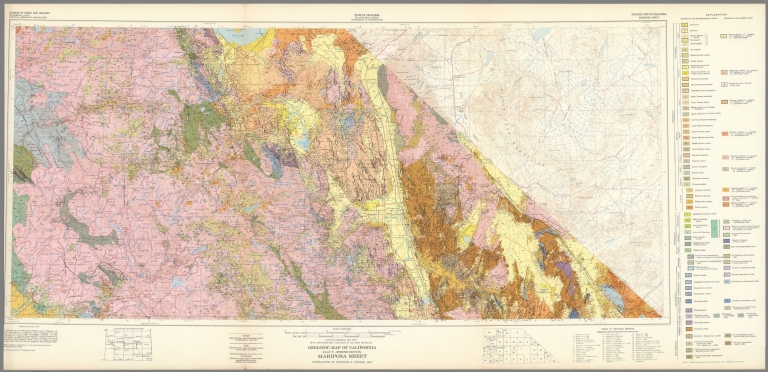
Author
California Division of Mines and Geology
Full Title
Geologic Map of California, Mariposa Sheet.
List No
6347.041
Note
Full color. Olaf P. Jenkins Edition.
Author
California Division of Mines and Geology
Full Title
Geologic Map of California, Needles Sheet.
List No
6347.045
Note
Full color. Olaf P. Jenkins Edition.
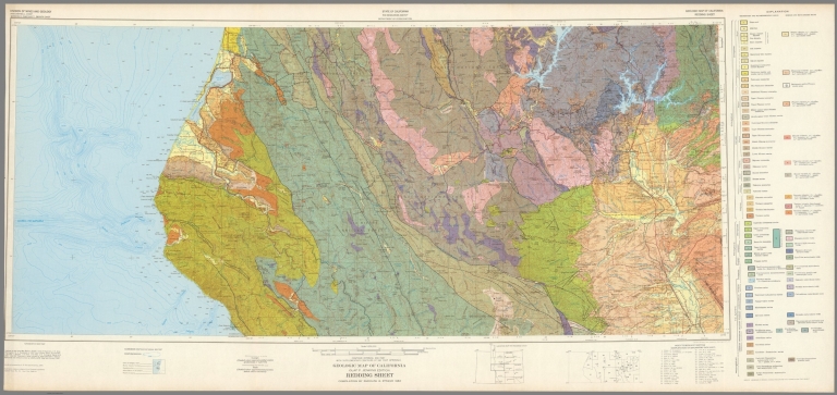
Author
California Division of Mines and Geology
Full Title
Geologic Map of California, Redding Sheet.
List No
6347.049
Note
Full color. Olaf P. Jenkins Edition.
|