|
REFINE
Browse All : Geology of California
1-126 of 126
Author
Jenkins, Olaf P.
Full Title
Sheet No. I Northern Section. Geologic Map of California Prepared by Olaf P. Jenkins Chief Geologist, Geologic Branch
List No
15485.001
Note
Dimensions are sheet size.
Author
Jenkins, Olaf P.
Full Title
Sheet No. II Central Section. Geologic Map of California Prepared by Olaf P. Jenkins Chief Geologist, Geologic Branch
List No
15485.002
Note
Dimensions are sheet size.
Author
Jenkins, Olaf P.
Full Title
Sheet No. III Southwest Coast Section. Geologic Map of California Prepared by Olaf P. Jenkins Chief Geologist, Geologic Branch.
List No
15485.003
Note
Dimensions are sheet size.
Author
Jenkins, Olaf P.
Full Title
Sheet No. IV Geologic Legend. Geologic Map of California Prepared by Olaf P. Jenkins Chief Geologist, Geologic Branch.
List No
15485.004
Note
Dimensions are sheet size.
Author
Jenkins, Olaf P.
Full Title
Sheet No. V East-Central Section. Geologic Map of California Prepared by Olaf P. Jenkins Chief Geologist, Geologic Branch.
List No
15485.005
Note
Dimensions are sheet size.
Author
Jenkins, Olaf P.
Full Title
Sheet No. VI Southern Section. Geologic Map of California Prepared by Olaf P. Jenkins Chief Geologist, Geologic Branch.
List No
15485.006
Note
Dimensions are sheet size.
Author
Jenkins, Olaf P.
Full Title
(Composite map of) Sections I-VI. Geologic Map of California Prepared by Olaf P. Jenkins Chief Geologist, Geologic Branch
List No
15485.007
Note
Dimensions are sheet size.
Author
California Division of Mines and Geology
Full Title
Geologic Map of California, Los Angeles Sheet.
List No
6347.037
Note
Full color. Olaf P. Jenkins Edition.
Author
California Division of Mines and Geology
Full Title
(Composite Map) Geologic Map of California.
List No
6347.114
Note
Full color. Olaf P. Jenkins Edition. Individual sheets dated 1958-1969.
Author
Raymo, Chet
Full Title
(California, Nevada). (to accompany) A geologic and topographic profile of the United States along interstate 80 : by Chet Raymo. 1982. Printed by Hubbard, Northbrook, IL.
List No
13323.006
Note
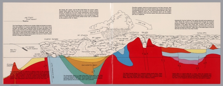
Geologic cross section and map. Covers the area from Pacific Ocean and San Francisco to Carson Sink, showing the volcanic peaks, fault zone, weather system, lakes, drainage, cities and mountains. Includes descriptive text.
Author
Raymo, Chet
Full Title
(Composite). A geologic and topographic profile of the United States along interstate 80 : by Chet Raymo. 1982. Printed by Hubbard, Northbrook, IL.
List No
13323.014
Note
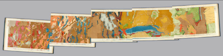
Composite of 8 sheets of geologic cross section and topographic map. Covers the route along Interstate 80 from San Francisco to New York City.
Author
[Uren, Charles Edward, Bradley & Co.]
Full Title
Map of Bradley & Co's ditch property near Alta Station after the slide. E.C. Uren.
List No
11715.000
Note
Hand colored manuscript map of two heavy slides of earth that obstructed the tracks of the Central Pacific Railway near Alta California. From historical records it appears that the map may detail two slides that occurred along the railroad. The largest slide occurred in the Spring of 1866 during construction of the railroad and is shown in the center of the map with damages and repairs to the various ditches that ran through the area. The April 21, 1866 edition of the Dutch Flat Enquirer mentions "LAND SLIDE.—A huge land slide occurred a few days since near Buckley's ranch, just above this place, on the line of the C. P. Railroad, damaging the ditches of the Dutch Flat Water Company to the amount of several thousand dollars, and rendering a change of the railroad bed necessary, which will also cost an immense sum. Nearly a quarter section, extending along a heavy fill of the railroad several hundred yards, suddenly gave way and moved off in a solid body, taking with it ditches, flumes and everything else that obstructed its course, and making a change from the original survey of the railroad at that point imperative. The material that gave way, it seems, was of a soapy or pipe clay formation, and the pressure from the railroad fill is assigned as the cause." We estimate the map was drawn by Uren in 1880, looking back at that 1866 slide and also showing the recent 1880 slide that blocked the tracks in the upper left part of the map. The 1880 slide was recorded in the Scientific American issue Volume 42, noting that hydraulic mining techniques were used to blast away the debris covering the tracks. The map is unusual in showing illustrations of two Chinese Camps near the railroad line. With decorative compass rose, oriented with the north to upper left margin. Map showing railroad, steam engine, two views of Chinese camps, slide areas and views of Flume and water ditches. Date estimated. Uren writes his name on the map as E.C. Uren while we believe he is Charles Edward Uren.
Author
[Berghaus, Heinrich, Berghaus, Hermann, Schmidt, C., Risch, M.]
Full Title
Tieflander. Entw. v. Herm. Berghaus 1883, Ausg. 1887. Gez. v. C. Schmidt u. M. Risch. Gotha: Justus Perthes. (On upper margin) I. Abt. Geologie No. II. Berghaus' physikal atlas No. 2. (to Accompany) Berghaus' Physikalischer Atlas. (Begrundet 1836 durch Heinrich Berghaus) ... Gotha: Justus Perthes. 1892.
List No
4391.013
Note
14 color lithograph maps with insets on 1 sheet. Includes: Die Heutigen Niederlande, with insets: Niederlande in 1. Jahrhundert -- Niederlande in X. Jahrhundert, at scale of 1: 6,000,000. Fen District -- El-Ghor oder das Jordan Thal -- Kaspisches Tiefland und Manytsch Niederrung -- Natron-Seen -- El Fajum -- Nordrand der Libyschen Wuste -- Das Todte Thal -- Colorado-Wuste -- Nordrand der Algerischen Sahara -- Goban n. Paulistischke -- Sud-Australische Seen -- Tiefland Asale -- Assal-See. Relief shown by contours and spot heights. Depth shown by gradient tints and soundings. Prime meridian is Greenwich.
Author
Guillemin-Tarayre, Edmond
Full Title
Carte Panoramique de la Region metallifere de Washoe (Etat de Nevada) par E. Guillemin-Tarayre. Cette carte est executee en projection gnomonique sur l'horizon du Mt. Davidson. Grave chex Erhard, Paris - Impr. Lemercier r. de Seine 57.
List No
11309.000
Note
Early map of Lake Tahoe and the Washoe Mining District on a Gnomonic Projection. One of the earliest geological and mining map of the region. Centered on Virginia City and extending to the Truckee River, Lake Tahoe, the Walker River and the Carson River. The outer ring of mountains locates Sevier Mountain, Pyramid Peak, Mt. Washoe, the Valley of the Carson River, and "Massif Palmyra." Towns named on the map include Washoe City, Fort Churchill, Genoa, Carson, with several dozen mines also named. Relief shown pictorially, by hachures and spot heights. Includes key to geological formation and notes. Guillemin-Tarayre's map is part of a rare set of scientific works published by the French government.
Author
Russell, Israel C. (Israel Cook), 1852-1906.
Full Title
Lake Lahontan : a quaternary lake of northwestern Nevad, by Israel C. Russell. Assisted by A.L. Webster, W.D. Johnson, cartographers ; W.J. McGee. GEO. M. Wright, geologists. Mountain shading, by W.J. Hays. Topography compiled by Eugene Rickseker ... (to accompany) Geological history of Lake Lahontan : a quaternary lake of Northwestern Nevada. (series title) Department of Interior : Monographs of the United States Geological Survey, vol. XI. (on upper margin) U.S. Geological Survey; Lake Lahontan PL. XLVI.
List No
0866.051
Note
Color map. Showing quaternary lakes, existing lakes and playas. Relief shown by contours and shadings. "Contours 1000 feet interval". Shows footprint of buildings and railroads.
Author
[U.S. Geological Survey, Alpha, Tau Rho]
Full Title
Southern California Borderland.
List No
6353.087
Author
King, Clarence
Full Title
(Covers to) Engineer Department U.S.A. Geological and Topographical Atlas Accompanying the Report of the Geological Exploration of the Fortieth Parallel Made by the Authority of the Honorable Secretary of War under the direction of Brig. and Brvt. Major General A.A. Humphreys, Chief of Engineers U.S.A. by Clarence King, U.S. Geologist in Charge, 1876. Julius Bien Lith.
List No
0408A
Author
King, Clarence
Full Title
(Title Page to) Engineer Department U.S.A. Geological and Topographical Atlas Accompanying the Report of the Geological Exploration of the Fortieth Parallel Made by the Authority of the Honorable Secretary of War under the direction of Brig. and Brvt. Major General A.A. Humphreys, Chief of Engineers U.S.A. by Clarence King, U.S. Geologist in Charge, 1876. Julius Bien Lith.
List No
0408B
Note
Magnificent, huge atlas showing the area of the 40th Parallel Survey in topographical and geological maps. Wheat notes: "These are pioneer survey maps, and as such are most interesting. Mapping the West in so broad a cross-section had never before been attempted, a portent of things to come." King, at the age of 25, was made Geologist-in-charge of the Survey in 1867. He was formally ordered "to examine and describe the geological structure, geographical condition and natural resources of a belt of country extending from the 120th meridian eastward to the 105th meridian, along the 40th parallel of latitude with sufficient expansion north and south to include the lines of 'Central' and 'Union Pacific' railroads..." (Wheat). The topographical sheets depict features by brush shading rather than hachuring. In original binding -rare. Bound in green half leather with a label on the front, "Geological and Topographical Atlas Accompanying the Report of the Geological Exploration of the Fortieth Parallel. Clarence King, Geologist in Charge."
Author
King, Clarence
Full Title
(Index Page to) Engineer Department U.S.A. Geological and Topographical Atlas Accompanying the Report of the Geological Exploration of the Fortieth Parallel Made by the Authority of the Honorable Secretary of War under the direction of Brig. and Brvt. Major General A.A. Humphreys, Chief of Engineers U.S.A. by Clarence King, U.S. Geologist in Charge, 1876. Julius Bien Lith.
List No
0408C
Note
Index page includes the list of maps and a legend naming the mapmakers and the basis by which the maps were made.
Author
King, Clarence
Full Title
Nevada Basin. Map V. (Geological)
List No
0408.006
Note
Map in full color with the legends on either side of the maps. Map extends from Argenta, Nevada to the west of Pyramid Lake (Lake Tahoe) in California. Below the map are two geologic cross sections.
Author
King, Clarence
Full Title
(Composite of) Geological Maps I-V, 40th Parallel Survey.
List No
0408.007
Note
Maps in full color with the legends on either side of the maps.
Author
King, Clarence
Full Title
General Sections.
List No
0408.008
Note
In full color. Ten sections shown with the legends on either side of the cross sections.
Author
Russell, Israel C. (Israel Cook), 1852-1906.
Full Title
Tufa domes in Mono Lake, California. (to accompany) Geological history of Lake Lahontan : a quaternary lake of Northwestern Nevada. (series title) Department of Interior : Monographs of the United States Geological Survey, vol. XI. (on upper margin) U.S. Geological Survey; Lake Lahontan PL. XLIII.
List No
0866.048
Note
Uncolored view.
Author
Russell, Israel C. (Israel Cook), 1852-1906.
Full Title
Post - quaternary fault lines. Julius Bien & Co. Lith. (to accompany) Geological history of Lake Lahontan : a quaternary lake of Northwestern Nevada. (series title) Department of Interior : Monographs of the United States Geological Survey, vol. XI. (on upper margin) U.S. Geological Survey; Lake Lahontan PL. XLIV.
List No
0866.049
Note
Color map. Shows railroads. Fault lines shown in red. Relief shown by contours and shadings. Depth shown by isolines.
Author
Russell, Israel C. (Israel Cook), 1852-1906.
Full Title
Post - quaternary fault on the south shore of Humboldt Lake. (to accompany) Geological history of Lake Lahontan : a quaternary lake of Northwestern Nevada. (series title) Department of Interior : Monographs of the United States Geological Survey, vol. XI. (on upper margin) U.S. Geological Survey; Lake Lahontan PL. XLV.
List No
0866.050
Note
Uncolored view.
Author
[Scovel, James L., O'Brien, Emmett J]
Full Title
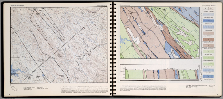
Crystalline Masses. Belted Metamorphic. San Andreas, Calif. (on opposite page) Geologic Map and Cross-Section of San Andreas, Calif.
List No
0889.032
Note
Contour and geologic maps, with text, and location map. Relief shown by contours and spot height.
Author
[Scovel, James L., O'Brien, Emmett J]
Full Title
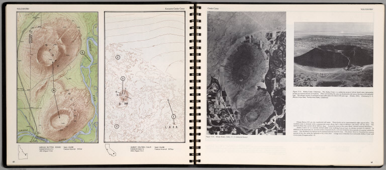
Vulcanism. Extrusive Cinder Cones. Menan Buttes, Idaho. Amboy Cratet, Calif. (on opposite page) Cinder Cones. (Views of) Manon Buttes, Idaho, and Amboy Crater, California.
List No
0889.035
Note
Two contour maps on one page. With location maps. Two views, and text on opposite page. Relief shown by contours and spot height.
Author
[Scovel, James L., O'Brien, Emmett J]
Full Title
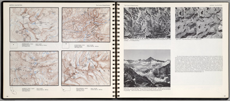
Alpine Glaciation. The Cycle of Glacial Erosion. Georgetown, Colo. Scale 1:62,500. Cloud Peak, Wyo. Scale 1:125,000. Mineral King, Calif. Scale 1:62,500. Phillipsburg, Mont. Scale 1:125,000.(on opposite page three views of )The Cycle of Glacial Erosion.
List No
0889.057
Note
Four on one page, with text, and location map. Includes three views of Georgetown, Colorado; Cloud Peak, Wyoming; and A series of paternoster lakes in a maturely dissected glacial range. Relief shown by contours and spot heights.
Author
[Scovel, James L., O'Brien, Emmett J]
Full Title
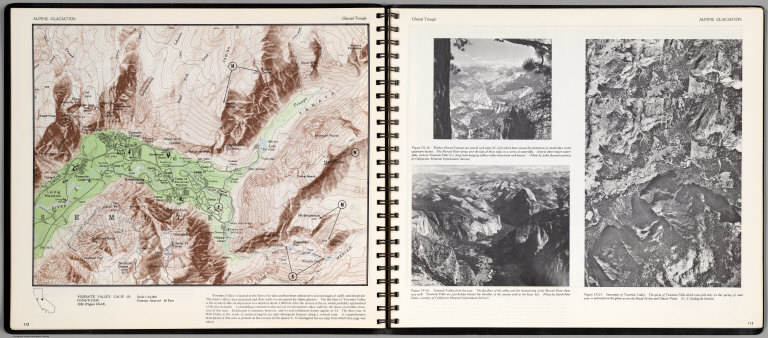
Alpine Glaciation. Glacial Trough. Yosemite Valley, Calif. (S) (on opposite page) Stereopair of Yosemite Valley, (two views) Within Merced Canyon ..., Yosemite Valley from the West ...
List No
0889.060
Note
Color map, with text, and location map. Relief shown by contours and spot heights.
Author
[Scovel, James L., O'Brien, Emmett J]
Full Title
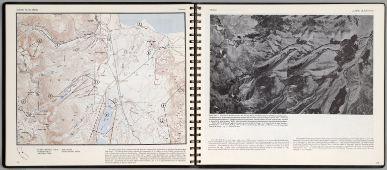
Alpine Glaciation. Moraine. Mono Craters, Calif. (on opposite page) Stereopair of Mono Craters ...
List No
0889.061
Note
Color map, with text, and location map. Relief shown by contours and spot heights.
Author
[Scovel, James L., O'Brien, Emmett J]
Full Title
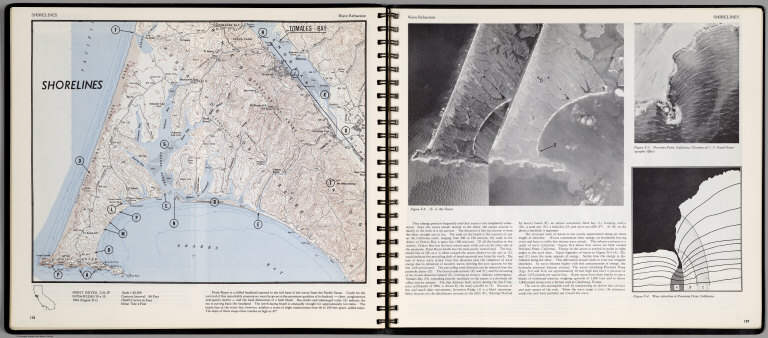
Shorelines. Wave Refraction. Point Reyes, Calif. (on opposite page) Three views.
List No
0889.068
Note
Contour color map, with location map and text. Views: aerial views of Point Reyes, Purisima Point, California, and Wave Fraction at Purisima Point, California. Relief shown by contours and spot heights.
Author
[Scovel, James L., O'Brien, Emmett J]
Full Title
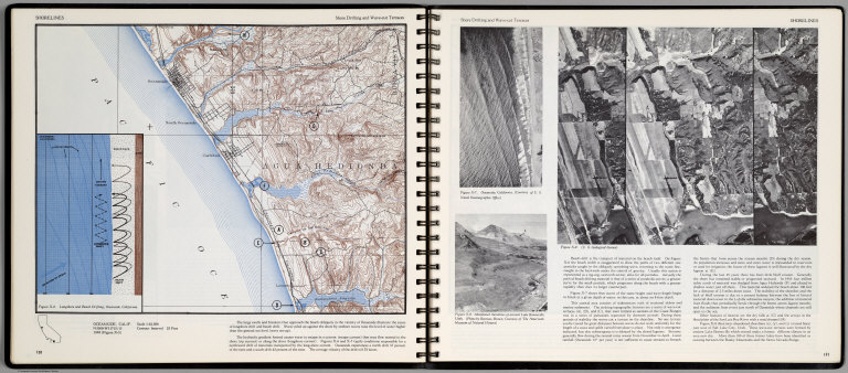
Shorelines. Shore Drifting and Wave-cut Terraces. Oceanside, Calif. (inset) Longshore and Beach Drifting, Oceanside, California. (on opposite page three views).
List No
0889.069
Note
Contour color map, with location map and text. Views: Oceanside, California; Abandoned shorlines of ancient Lake Bonnevile, Utah; and view showing series of wave-cut terraces (A), (B), and (C) ... Relief shown by contours and spot heights.
Author
[Scovel, James L., O'Brien, Emmett J]
Full Title
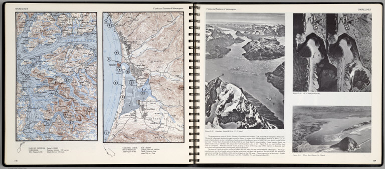
Shorelines. Fiords and Features of Submergence. Narvik, Norway. Cayucos, Calif. Scale 1:62,500. (insets) Providence, R.I., and Outwash Plain before and after water attack. (with three views on opposite page).
List No
0889.073
Note
Two contour color maps, with location map and text. View of Greenland, and two views of Morro Bay, California. Relief shown by contours and spot heights.
Author
[Scovel, James L., O'Brien, Emmett J]
Full Title
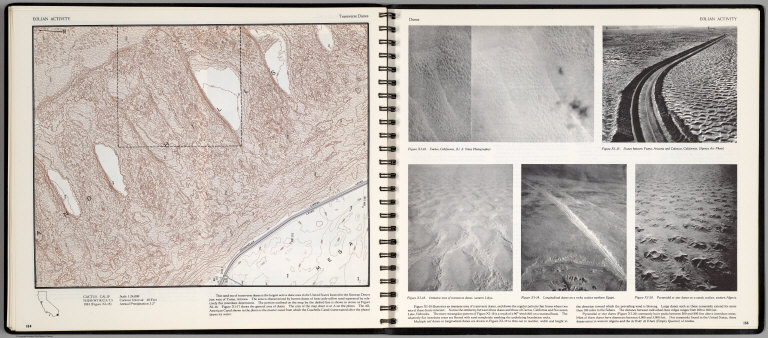
Eolian Activity. Transverse Dunes. Cactus, Calif. (with aerial views on opposite page)
List No
0889.081
Note
Contour color maps, with location map and text. Aerial views: Cactus, California, Dunes between Yuma, Arizona and Calexico, California, Immense area of transverse dunes, western Libya, Longitudinal dunes on a rocky surface northern Egypt, and Pyramid or star dunes on a sandy surface, western Algeria. Relief shown by contours and spot heights.
Author
Berghaus, Hermann
Full Title
Nord-Amerika. Ubersicht von Nord-Amerika. (with) Virginia-Silber-Minen. (with) Das Yosemite-Thal. (with) Landenge von Tehuantepec n. J.C. Spear 1871. (with) Landenge von Nicaragua. (with) Die Krater des Turrialba. (with) Landenge von Panama. (with) Seeboden der New-York-Bay. (with) Popocatepetl. (with) Citlaltepetl. (with) Canons des Colorado. (with) Yellowstone-National-Park. (with) Reykjanes und Geyser nach Th. Thoroddsen. Entw. v. Herm. Berghaus 1886, Ausg. 1887. Nebenkarten gez. v. M. Risch. Gotha: Justus Perthes (1892)
List No
1578.012
Note
Lithographed geologic map, color with 12 inset maps. Relief shown by spot heights. Some inset maps are topographic maps showing relief by hachures and spot heights.
Author
[Branner, John Casper, California. State Earthquake Investigation Commission, Gilbert, G. K., Lawson, Andrew C., Reid, Harry Fielding]
Full Title
(Covers to) Atlas of maps and seismograms accompanying the report of the State Earthquake Investigation Commission upon the California earthquake of April 18, 1906. Andrew C. Lawson, G.K. Gilbert, H.F. Reid, J.C. Branner, A.O. Leuschner, George Davidson, Charles Burckhalter, W.W. Campbell. Carnegie Institution of Washington. Washington, D.C. 1908. (seal) Carnegie Institution of Washington 1902.
List No
2130A
Note
Dark green cloth covered boards with the title embossed in gold on the front cover.
Author
[Branner, John Casper, California. State Earthquake Investigation Commission, Gilbert, G. K., Lawson, Andrew C., Reid, Harry Fielding]
Full Title
(Title Page to) Atlas of maps and seismograms accompanying the report of the State Earthquake Investigation Commission upon the California earthquake of April 18, 1906. Andrew C. Lawson, G.K. Gilbert, H.F. Reid, J.C. Branner, A.O. Leuschner, George Davidson, Charles Burckhalter, W.W. Campbell. Carnegie Institution of Washington. Washington, D.C. 1908. (seal) Carnegie Institution of Washington 1902.
List No
2130B
Note
This atlas accompanied several text volumes (David Rumsey Collection has reproductions) and was the most complete mapping of the great earthquake of 1906. Maps printed in full and partial color. Covers are dark green cloth covered boards with the title embossed in gold on the front cover.
Author
[Branner, John Casper, California. State Earthquake Investigation Commission, Gilbert, G. K., Lawson, Andrew C., Reid, Harry Fielding]
Full Title
(Contents to) Atlas of maps and seismograms accompanying the report of the State Earthquake Investigation Commission upon the California earthquake of April 18, 1906. Andrew C. Lawson, G.K. Gilbert, H.F. Reid, J.C. Branner, A.O. Leuschner, George Davidson, Charles Burckhalter, W.W. Campbell. Carnegie Institution of Washington. Washington, D.C. 1908. (seal) Carnegie Institution of Washington 1902.
List No
2130C
Note
Table of contents.
Author
California. State Earthquake Investigation Commission
Full Title
Geomorphic map of California and Nevada with portions of Oregon and Idaho showing the diastrophic character of the relief, the steep descent from the sub-continental shelf to the floor of the Pacific, and the more important known faults. Earthquake Investigation Commission. Drawn by M. Solem. A. Hoen & Co., Baltimore. (Carnegie Institution of Washington, 1908)
List No
2130.001
Note
Color. Relief shown by hachures; depths by bathymetric isolines. Shows railways, towns, counties and drainage.
Author
California. State Earthquake Investigation Commission
Full Title
Map of a portion of the coast of California showing the San Andreas Rift from Point Arena to Fort Ross and the trace of the fault of April 18, 1906. Earthquake Investigation Commission. Julius Bien & Co., N.Y. (Carnegie Institution of Washington. 1908)
List No
2130.002
Note
Color. Also shows settlements, townships and sections, roads and drainage. "Compiled from the official maps of Sonoma and Mendocino Counties."
Author
[California. State Earthquake Investigation Commission, Matthes, Francois E.]
Full Title
Detail map of a typical portion of the San Andreas Rift near Fort Ross, Sonoma County, California showing its geomorphic features and the trace of the fault by Francois E. Matthes. Earthquake Investigation Commission. A. Hoen & Co., Baltimore. (Carnegie Institution of Washington. 1908)
List No
2130.003
Note
Color. Contour interval 5 ft. Shows roads, trails, houses, fences, ponds, streams, marshes, etc. Inset: Index map.
Author
California. State Earthquake Investigation Commission
Full Title
Map of the region about San Francisco Bay showing the relation of the city of San Francisco to the San Andreas Rift, the fault of April 18, 1906 and the fault of October 21, 1868. Earthquake Investigation Commission. Julius Bien & Co., Lith., N.Y. (Carnegie Institution of Washington. 1908)
List No
2130.004
Note
Color. Relief shown by contours and spot heights; depths by soundings and isoline. "Topography by the C. and G. Survey and the U.S. Geological Survey."
Author
California. State Earthquake Investigation Commission
Full Title
Map of a portion of the Coast Ranges of California showing the San Andreas Rift. Earthquake Investigation Commission. Julius Bien & Co., Lith., N.Y. (Carnegie Institution of Washington. 1908)
List No
2130.005
Note
Color. Contour interval 500 ft. Shows settlements, railroads, etc.
Author
[California. State Earthquake Investigation Commission, U.S. Geological Survey]
Full Title
California, Mt. Pinos quadrangle of the U.S. Geological Survey showing the San Andreas Rift. Earthquake Investigation Commission. (Carnegie Institution of Washington. 1908)
List No
2130.006
Note
Color. 30-minute topographic quadrangle. Relief shown by contours and spot heights. Covers portions of Ventura, Kern and Santa Barbara counties.
Author
[California. State Earthquake Investigation Commission, U.S. Geological Survey]
Full Title
California, Tejon quadrangle of the U.S. Geological Survey showing the San Andreas Rift. Earthquake Investigation Commission. (Carnegie Institution of Washington. 1908)
List No
2130.007
Note
Color. 30-minute topographic quadrangle. Relief shown by contours and spot heights. Covers portions of Kern, Los Angeles and Ventura counties.
Author
[California. State Earthquake Investigation Commission, U.S. Geological Survey]
Full Title
California, Palmdale quadrangle of the U.S. Geological Survey showing the San Andreas Rift. Earthquake Investigation Commission. A. Hoen & Co., Baltimore. (Carnegie Institution of Washington. 1908)
List No
2130.008
Note
Color. 30-minute topographic quadrangle. Relief shown by contours and spot heights. Covers portions of Kern and Los Angeles counties.
Author
[California. State Earthquake Investigation Commission, U.S. Geological Survey]
Full Title
California, Rock Creek quadrangle of the U.S. Geological Survey showing the San Andreas Rift. Earthquake Investigation Commission. Andrew B. Graham Co., Lithographers, Washington, D.C. (Carnegie Institution of Washington. 1908)
List No
2130.009
Note
Color. 15-minute topographic quadrangle. Relief shown by contours and spot heights. In Los Angeles County.
Author
[California. State Earthquake Investigation Commission, U.S. Geological Survey]
Full Title
California, San Antonio quadrangle of the U.S. Geological Survey showing the San Andreas Rift. Earthquake Investigation Commission. Andrew B. Graham Co., Lithographers, Washington, D.C. (Carnegie Institution of Washington. 1908)
List No
2130.010
Note
Color. 15-minute topographic quadrangle. Relief shown by contours and spot heights. Covers portions of Los Angeles and San Bernardino counties.
Author
[California. State Earthquake Investigation Commission, U.S. Geological Survey]
Full Title
California, Hesperia quadrangle of the U.S. Geological Survey showing the San Andreas Rift. Earthquake Investigation Commission. Andrew B. Graham Co., Lithographers, Washington, D.C. (Carnegie Institution of Washington. 1908)
List No
2130.011
Note
Color. 15-minute topographic quadrangle. Relief shown by contours and spot heights. Covers portion of San Bernardino County.
Author
[California. State Earthquake Investigation Commission, U.S. Geological Survey]
Full Title
California, San Bernardino quadrangle of the U.S. Geological Survey showing the San Andreas Rift. Earthquake Investigation Commission. Andrew B. Graham Co., Lithographers, Washington, D.C. (Carnegie Institution of Washington. 1908)
List No
2130.012
Note
Color. 15-minute topographic quadrangle. Relief shown by contours and spot heights. Covers portions of San Bernardino and Riverside counties.
Author
[California. State Earthquake Investigation Commission, U.S. Geological Survey]
Full Title
California, Redlands quadrangle of the U.S. Geological Survey showing the San Andreas Rift. Earthquake Investigation Commission. Andrew B. Graham Co., Lithographers, Washington, D.C. (Carnegie Institution of Washington. 1908)
List No
2130.013
Note
Color. 15-minute topographic quadrangle. Relief shown by contours and spot heights. Covers portions of San Bernardino and Riverside counties.
Author
[California. State Earthquake Investigation Commission, U.S. Geological Survey]
Full Title
California, San Gorgonio quadrangle of the U.S. Geological Survey showing the San Andreas Rift and the Mission Creek Fault. Earthquake Investigation Commission. Andrew B. Graham Co., Lithographers, Washington, D.C. (Carnegie Institution of Washington. 1908)
List No
2130.014
Note
Color. 30-minute topographic quadrangle. Relief shown by contours and spot heights. Covers portions of San Bernardino and Riverside counties.
Author
[California. State Earthquake Investigation Commission, U.S. Geological Survey]
Full Title
California, San Jacinto quadrangle of the U.S. Geological Survey showing the San Andreas Rift, the Mission Creek Fault and the San Jacinto Fault. Earthquake Investigation Commission. Andrew B. Graham Co., Lithographers, Washington, D.C. (Carnegie Institution of Washington. 1908)
List No
2130.015
Note
Color. 30-minute topographic quadrangle. Relief shown by contours and spot heights. Covers portions of Riverside County.
Author
California. State Earthquake Investigation Commission
Full Title
Map of the city of Santa Rosa, Sonoma County, California showing the portions destroyed by the earthquake of April 18, 1906, and by the fire consequent thereto. Earthquake Investigation Commission. A. Hoen & Co., Baltimore. (Carnegie Institution of Washington. 1908)
List No
2130.016
Note
Relief shown by hachures. Shows buildings destroyed by earthquake and following fire.
Author
[California. State Earthquake Investigation Commission, Lawson, Andrew C., Wood, Harry O.]
Full Title
Geological map of the city of San Francisco by Andrew C. Lawson. To accompany the paper by H.O. Wood. Earthquake Investigation Commission. A. Hoen & Co. (Carnegie Institution of Washington. 1908)
List No
2130.017
Note
Color. Relief shown by contours and spot heights. Shows 10 geologic units and original shoreline. "Topography by the Coast and Geodetic Survey." For sections see map 18.
Author
[California. State Earthquake Investigation Commission, Wood, Harry O.]
Full Title
Geological profiles with corresponding intensity curves across the city of San Francisco. To accompany the paper by H.O. Wood. Earthquake Investigation Commission. A. Hoen & Co. (Carnegie Institution of Washington. 1908)
List No
2130.018
Note
Color. Six sections with legend and explanatory note. Shows 10 geologic units. Accompanies map 17.
Author
[California. State Earthquake Investigation Commission, Wood, Harry O.]
Full Title
Map of San Francisco showing distribution of apparent intensity of the earthquake shock by H.O. Wood. Earthquake Investigation Commission. A. Hoen & Co., Baltimore. (Carnegie Institution of Washington. 1908)
List No
2130.019
Note
Color. Relief shown by contours and spot heights. "Topography by the Coast and Geodetic Survey."
Author
California. State Earthquake Investigation Commission
Full Title
Map of the city of San Francisco showing the streets and the burnt area, 1906. Earthquake Investigation Commission. Britton & Rey, engravers, San Francisco. (Carnegie Institution of Washington. 1908)
List No
2130.020
Note
Color. Shows block numbers, tracts, railroads, original shoreline, etc.
Author
[California. State Earthquake Investigation Commission, U.S. Geological Survey]
Full Title
California, San Mateo quadrangle of the U.S. Geological Survey showing the distribution of apparent intensity, the known faults, and the routes examined. Earthquake Investigation Commission. A. Hoen & Co., Baltimore. (Carnegie Institution of Washington. 1908)
List No
2130.021
Note
Color. 15-minute topographic quadrangle. Relief shown by contours and spot heights. Covers portions of San Mateo and San Francisco counties. Rossi-Forel scale.
Author
[California. State Earthquake Investigation Commission, U.S. Geological Survey]
Full Title
California, Santa Cruz quadrangle of the U.S. Geological Survey showing the distribution of apparent intensity, the known faults, the routes examined and the numbered localities referred to in the text. Earthquake Investigation Commission. A. Hoen & Co., Baltimore. (Carnegie Institution of Washington. 1908)
List No
2130.022
Note
Color. 30-minute topographic quadrangle. Relief shown by contours and spot heights. Covers portions of San Mateo, Santa Clara and Santa Cruz counties. Rossi-Forel scale.
Author
California. State Earthquake Investigation Commission
Full Title
Map of California and Nevada showing the distribution of apparent intensity in the region affected by the earthquake of April 18, 1906. Drawn by M. Solem. Earthquake Investigation Commission. A. Hoen & Co., Baltimore. (Carnegie Institution of Washington. 1908)
List No
2130.023
Note
Color. Covers also parts of Oregon and Idaho. Rossi-Forel scale.
Author
California. State Earthquake Investigation Commission
Full Title
Map of the Coast Range Region of Middle California showing the distribution of earth movement on April 18, 1906 as revealed by the displacement of the triangulation stations of the Coast and Geodetic Surveyed, determined by resurvey, 1906-07. Drawn by M. Solem. Earthquake Investigation Commission. A. Hoen & Co., Baltimore. (Carnegie Institution of Washington. 1908)
List No
2130.024
Note
Color. Shows fault of 1906, movement of 1906, successive movements of 1868 and 1906, combined movements of 1868 and 1906, railroads, settlements, etc.
Author
California. State Earthquake Investigation Commission
Full Title
Distribution of earth movement on April 18, 1906 and in 1868 as revealed by the displacement of the triangulation stations of the Coast and Geodetic Surveyed, determined by resurvey, 1906-07. Earthquake Investigation Commission. A. Hoen & Co., Baltimore. (Carnegie Institution of Washington. 1908)
List No
2130.025
Note
Four color maps. Contents: No. 1. Point Arena and vicinity -- No. 2. Fort Ross and vicinity -- No. 3. Tomales Bay -- No. 4. Colma and vicinity.
Author
California. State Earthquake Investigation Commission
Full Title
Seismograms - sheet no. 1. Earthquake Investigation Commission. (Carnegie Institution of Washington. 1908)
List No
2130.026
Note
Black and white reproductions of April 18, 1906 earthquake from various stations.
Author
California. State Earthquake Investigation Commission
Full Title
Seismograms - sheet no. 2. Earthquake Investigation Commission. (Carnegie Institution of Washington. 1908)
List No
2130.027
Note
Black and white reproductions of April 18, 1906 earthquake from various stations.
Author
California. State Earthquake Investigation Commission
Full Title
Seismograms - sheet no. 2A. Earthquake Investigation Commission. (Carnegie Institution of Washington. 1908)
List No
2130.028
Note
Black and white reproductions of April 18, 1906 earthquake from various stations.
Author
California. State Earthquake Investigation Commission
Full Title
Seismograms - sheet no. 3. Earthquake Investigation Commission. Photo. lith. by A. Hoen & Co., Baltimore, Md. (Carnegie Institution of Washington. 1908)
List No
2130.029
Note
Black and white reproductions of April 18, 1906 earthquake from various stations.
Author
California. State Earthquake Investigation Commission
Full Title
Seismograms - sheet no. 4. Earthquake Investigation Commission. Photo lith. by A. Hoen & Co., Baltimore, Md. (Carnegie Institution of Washington. 1908)
List No
2130.030
Note
Black and white reproductions of April 18, 1906 earthquake from various stations.
Author
California. State Earthquake Investigation Commission
Full Title
Seismograms - sheet no. 5. Earthquake Investigation Commission. Photo lith. by A. Hoen & Co., Baltimore, Md. (Carnegie Institution of Washington. 1908)
List No
2130.031
Note
Black and white reproductions of April 18, 1906 earthquake from various stations.
Author
California. State Earthquake Investigation Commission
Full Title
Seismograms - sheet no. 6. Earthquake Investigation Commission. Photo lith. by A. Hoen & Co., Baltimore, Md. (Carnegie Institution of Washington. 1908)
List No
2130.032
Note
Black and white reproductions of April 18, 1906 earthquake from various stations.
Author
California. State Earthquake Investigation Commission
Full Title
Seismograms - sheet no. 7. Earthquake Investigation Commission. Photo lith. by A. Hoen & Co., Baltimore, Md. (Carnegie Institution of Washington. 1908)
List No
2130.033
Note
Black and white reproductions of April 18, 1906 earthquake from various stations.
Author
California. State Earthquake Investigation Commission
Full Title
Seismograms - sheet no. 8. Earthquake Investigation Commission. Photo lith. by A. Hoen & Co., Baltimore, Md. (Carnegie Institution of Washington. 1908)
List No
2130.034
Note
Black and white reproductions of April 18, 1906 earthquake from various stations.
Author
California. State Earthquake Investigation Commission
Full Title
Seismograms - sheet no. 9. Earthquake Investigation Commission. Photo lith. by A. Hoen & Co., Baltimore, Md. (Carnegie Institution of Washington. 1908)
List No
2130.035
Note
Black and white reproductions of April 18, 1906 earthquake from various stations.
Author
California. State Earthquake Investigation Commission
Full Title
Seismograms - sheet no. 10. Earthquake Investigation Commission. Photo lith. by A. Hoen & Co., Baltimore, Md. (Carnegie Institution of Washington. 1908)
List No
2130.036
Note
Black and white reproductions of April 18, 1906 earthquake from various stations.
Author
California. State Earthquake Investigation Commission
Full Title
Seismograms - sheet no. 11. Earthquake Investigation Commission. Photo lith. by A. Hoen & Co., Baltimore, Md. (Carnegie Institution of Washington. 1908)
List No
2130.037
Note
Black and white reproductions of April 18, 1906 earthquake from various stations.
Author
California. State Earthquake Investigation Commission
Full Title
Seismograms - sheet no. 12. Earthquake Investigation Commission. Photo lith. by A. Hoen & Co., Baltimore, Md. (Carnegie Institution of Washington. 1908)
List No
2130.038
Note
Black and white reproductions of April 18, 1906 earthquake from various stations.
Author
California. State Earthquake Investigation Commission
Full Title
Seismograms - sheet no. 13. Earthquake Investigation Commission. Photo lith. by A. Hoen & Co., Baltimore, Md. (Carnegie Institution of Washington. 1908)
List No
2130.039
Note
Black and white reproductions of April 18, 1906 earthquake from various stations.
Author
California. State Earthquake Investigation Commission
Full Title
Seismograms - sheet no. 14. Earthquake Investigation Commission. Photo lith. by A. Hoen & Co., Baltimore, Md. (Carnegie Institution of Washington. 1908)
List No
2130.040
Note
Black and white reproductions of April 18, 1906 earthquake from various stations.
Author
California. State Earthquake Investigation Commission
Full Title
Seismograms - sheet no. 15. Earthquake Investigation Commission. Photo lith. by A. Hoen & Co., Baltimore, Md. (Carnegie Institution of Washington. 1908)
List No
2130.041
Note
Black and white reproductions of April 18, 1906 earthquake from various stations.
Author
Wheeler, G.M.
Full Title
Atlas Sheet Number 58. Parts Of E. California, S.E. Nevada, N.W. Arizona & S.W. Utah. Atlas Sheet Number 66. Weyss, Herman & Aguirre, Del. Expeditions of 1872 & 1873, Under the Command of 1st. Lieut. Geo. M. Wheeler, Corps of Engineers, U.S. Army. Geological Assistants: G.K. Gilbert, A.R. Marvine and E.E. Howell. U.S. Geographical Surveys West Of The One-Hundredth Meridian.
List No
2738.045
Note
Two partial atlas sheets on one page. In crayon and showing geological formations in tints. Color legend on outside of each map.
Author
Becker, George F.
Full Title
Geological Map of the Sulphur Bank District. U.S. Geological Survey. Monograph XIII, Atlas Sheet IV. S.H. Bodfish 1882, J.D. Hoffman 1884, Topographers. Giles Litho. & Liberty Printing Co. Geo. F. Becker, Geologist in charge.
List No
4580.002
Note
Shows in color three classes of rock. Relief shown by 20-foot contour lines. Shows mines, streams, and settlements.
Author
Becker, George F.
Full Title
Geological Map of the Knoxville District. U.S. Geological Survey. Monograph XIII, Atlas Sheet V. Topography by J.D. Hoffman 1883. Geo. F. Becker, Geologist in charge. Topographical Map of the Region of Clear Lake. Compiled by C.F. Hoffmann. Geo. F. Becker, Geologist in charge.
List No
4580.003
Note
Two maps on one sheet. Knoxville District map relief shown with 25-foot contours. Shows in color five classes of rock. Longitude and latitude shown. Scale 1:15,000. Clear Lake Region map shows topography with shaded relief, streams, mines, settlements, and roads. Scale 1:95,000. Outlines of Sulphur Bank District and Knoxville District shown.
Author
Becker, George F.
Full Title
Geological Map of the New Idria District. U.S. Geological Survey. Monograph XIII, Atlas Sheet VI. J.D. Hoffman, Topographer. Giles Litho. & Liberty Printing Co. N.Y. Geo. F. Becker, Geologist in charge.
List No
4580.004
Note
Shows in color three classes of rock. Relief shown by 40-foot contour lines. Shows streams, settlements, mines, trails, and roads.
Author
Becker, George F.
Full Title
Geological Map of the New Almaden Mining District. U.S. Geological Survey. Monograph XIII, Atlas Sheet VII. Topography by S.W. Bodfish and others. Giles Litho. & Liberty Printing Co. N.Y. Geo. F. Becker, Geologist in charge.
List No
4580.005
Note
Shows in color six classes of rock. Relief shown by 20-foot contour lines. Shows streams, settlements, mines, and roads.
Author
Becker, George F.
Full Title
Ore-Bodies and Topography of Mine-Hill, New Almaden. U.S. Geological Survey. Monograph XIII, Atlas Sheet VIII. Compiled by F. Reade 1885. Giles Litho. & Liberty Printing Co. N.Y. Geo. F. Becker, Geologist in charge.
List No
4580.006
Note
Shows in topography with 10-foot contours, ore bodies with cross-hatching, mine dumps with hachures, +streams, roads, tramways, tunnels and shafts.
Author
Becker, George F.
Full Title
Plan of the New Almaden Mine. U.S. Geological Survey. Monograph XIII, Atlas Sheet IX. Compiled by F. Reade 1885. Giles Litho. & Liberty Printing Co. N.Y. Geo. F. Becker, Geologist in charge.
List No
4580.007
Note
Shows depths, tunnels, drifts, galleries, and shafts in brilliant color.
Author
Becker, George F.
Full Title
Longitudinal Section of the South Ore Channel. New Almaden Mine. U.S. Geological Survey. Monograph XIII, Atlas Sheet X. Compiled by F. Reade 1885. Giles Litho. & Liberty Printing Co. N.Y. Geo. F. Becker, Geologist in charge.
List No
4580.008
Note
Shows depths, tunnels, drifts, galleries, and shafts.
Author
Becker, George F.
Full Title
North and South Section , 550 Feet West of Randol Shaft, New Almaden Mine. North and South Section through the Randol Shaft, New Almaden Mine. U.S. Geological Survey. Monograph XIII, Atlas Sheet XI. Compiled by F. Reade 1885. Geo. F. Becker, Geologist in charge.
List No
4580.009
Note
Two vertical sections on one sheet. Shows depths, tunnels, drifts, galleries, and shafts.
Author
Becker, George F.
Full Title
East and West Vertical Section, New Almaden Mine. U.S. Geological Survey. Monograph XIII, Atlas Sheet XII. Compiled by F. Reade 1885. Geo. F. Becker, Geologist in charge.
List No
4580.010
Note
Shows depths, tunnels, drifts, galleries, and shafts.
Author
Becker, George F.
Full Title
Plan of the Clay Walls, New Almaden Mine. U.S. Geological Survey. Monograph XIII, Atlas Sheet XIII. Compiled by F. Reade 1885. Giles Litho. & Liberty Printing Co. N.Y. Geo. F. Becker, Geologist in charge.
List No
4580.011
Note
Shows alignments of clay walls.
Author
California Division of Mines and Geology
Full Title
Geologic Map of California, Alturas Sheet.
List No
6347.009
Note
Full color.
Author
California Division of Mines and Geology
Full Title
Geologic Map of California, Bakersfield Sheet.
List No
6347.013
Note
Full color.
Author
California Division of Mines and Geology
Full Title
Geologic Map of California, Chico Sheet.
List No
6347.017
Note
Full color.
Author
California Division of Mines and Geology
Full Title
Geologic Map of California, Death Valley Sheet.
List No
6347.021
Note
Full color. Olaf P. Jenkins Edition.
Author
California Division of Mines and Geology
Full Title
Geologic Map of California, Fresno Sheet.
List No
6347.025
Note
Full color. Olaf P. Jenkins Edition.
Author
California Division of Mines and Geology
Full Title
Geologic Map of California, Kingman Sheet.
List No
6347.029
Note
Full color. Olaf P. Jenkins Edition.
Author
California Division of Mines and Geology
Full Title
Geologic Map of California, Long Beach Sheet.
List No
6347.033
Note
Full color. Olaf P. Jenkins Edition.
Author
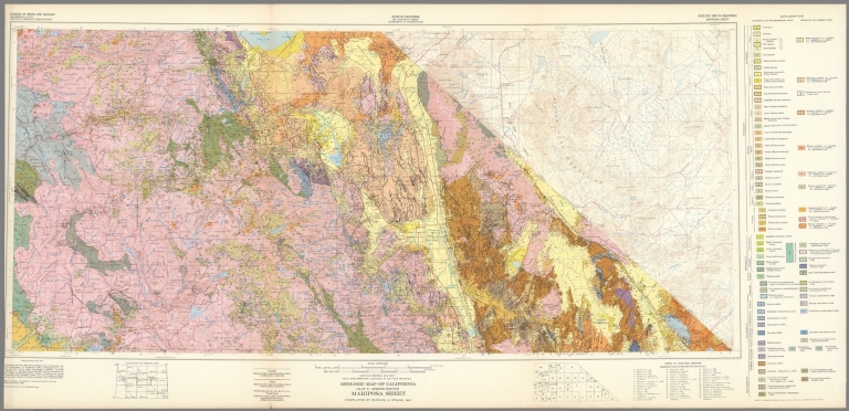
California Division of Mines and Geology
Full Title
Geologic Map of California, Mariposa Sheet.
List No
6347.041
Note
Full color. Olaf P. Jenkins Edition.
Author
California Division of Mines and Geology
Full Title
Geologic Map of California, Needles Sheet.
List No
6347.045
Note
Full color. Olaf P. Jenkins Edition.
Author
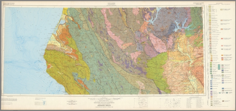
California Division of Mines and Geology
Full Title
Geologic Map of California, Redding Sheet.
List No
6347.049
Note
Full color. Olaf P. Jenkins Edition.
Author
California Division of Mines and Geology
Full Title
Geologic Map of California, Sacramento Sheet.
List No
6347.053
Note
Full color. Olaf P. Jenkins Edition.
Author
California Division of Mines and Geology
Full Title
Geologic Map of California, Salton Sea Sheet.
List No
6347.057
Note
Full color. Olaf P. Jenkins Edition.
Author
California Division of Mines and Geology
Full Title
Geologic Map of California, San Bernadino Sheet.
List No
6347.061
Note
Full color. Olaf P. Jenkins Edition.
Author
California Division of Mines and Geology
Full Title
Geologic Map of California, San Diego - El Centro Sheet.
List No
6347.065
Note
Full color. Olaf P. Jenkins Edition.
Author
California Division of Mines and Geology
Full Title
Geologic Map of California, San Francisco Sheet.
List No
6347.069
Note
Full color. Olaf P. Jenkins Edition.
Author
California Division of Mines and Geology
Full Title
Geologic Map of California, San Jose Sheet.
List No
6347.073
Note
Full color. Olaf P. Jenkins Edition.
Author
California Division of Mines and Geology
Full Title
Geologic Map of California, San Luis Obisbo Sheet.
List No
6347.077
Note
Full color. Olaf P. Jenkins Edition.
Author
California Division of Mines and Geology
Full Title
Geologic Map of California, Santa Ana Sheet.
List No
6347.081
Note
Full color. Olaf P. Jenkins Edition.
Author
California Division of Mines and Geology
Full Title
Geologic Map of California, Santa Cruz Sheet.
List No
6347.085
Note
Full color. Olaf P. Jenkins Edition.
Author
California Division of Mines and Geology
Full Title
Geologic Map of California, Santa Maria Sheet.
List No
6347.089
Note
Full color. Olaf P. Jenkins Edition.
Author
California Division of Mines and Geology
Full Title
Geologic Map of California, Santa Rosa Sheet.
List No
6347.093
Note
Full color. Olaf P. Jenkins Edition.
Author
California Division of Mines and Geology
Full Title
Geologic Map of California, Trona Sheet.
List No
6347.097
Note
Full color. Olaf P. Jenkins Edition.
Author
California Division of Mines and Geology
Full Title
Geologic Map of California, Ukiah Sheet.
List No
6347.101
Note
Full color. Olaf P. Jenkins Edition.
Author
California Division of Mines and Geology
Full Title
Geologic Map of California, Walker Lake Sheet.
List No
6347.105
Note
Full color. Olaf P. Jenkins Edition.
Author
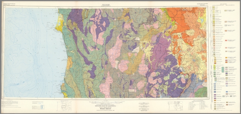
California Division of Mines and Geology
Full Title
Geologic Map of California, Weed Sheet.
List No
6347.109
Note
Full color. Olaf P. Jenkins Edition.
Author
California Division of Mines and Geology
Full Title
Geologic Map of California, Westwood Sheet.
List No
6347.113
Note
Full color. Olaf P. Jenkins Edition.
Author
[U.S. Geological Survey, Alpha, Tau Rho]
Full Title
Eastern Murray Fracture Zone and Transverse Ranges.
List No
6353.082
Author
[U.S. Geological Survey, Alpha, Tau Rho, Gerin, Marybeth]
Full Title
Oblique Map of the Northern California Continental Margin.
List No
6353.083
Author
[U.S. Geological Survey, Alpha, Tau Rho]
Full Title
Oblique Map of Southern California, Santa Barbara to San Deigo.
List No
6353.088
Author
[U.S. Geological Survey, Alpha, Tau Rho]
Full Title
Southern California Borderland Oblique Map of the Northwestern Part.
List No
6353.089
Author
[U.S. Geological Survey, Alpha, Tau Rho]
Full Title
Ventura-Oxnard Offshore.
List No
6353.091
Author
[Jennings, Charles W., California Division of Mines and Geology]
Full Title
Fault Map of California , w/ locations of Volcanoes, Thermal Springs, and Thermal Wells.
List No
7014.000
Note
Suitable for use in a seminar room; viewable up to 20 feet. Language(s): English. Map is plasticized paper. Mounted on wood rods. Prime Meridian is Greenwich. Projection is not specified. Topics include: seismic faults, volcanoes, thermal springs and wells, hydrography, county boundaries, transportation routes, cities. Department of Geography, University of California at Berkeley, Call Number 611-B-3.
Author
[Jennings, Charles W., Strand, R.G., Rogers, T.H.]
Full Title
Geologic Map of California.
List No
7035.000
Note
Suitable for use in a standard classroom; viewable up to 40 feet. Language(s): English. Map is paper. Mounted on wood rods. Projection is not specified. Department of Geography, University of California at Berkeley, Call Number 611-B-2.
Author
[Allan Cartography, Dynamic Graphics, Inc.]
Full Title
Tectonic California. Dynamic Graphics, Inc. ... Berkeley, California 94705 ....
List No
7869.000
Note
Shows California and Nevada and marine topography and the San Andreas Fault now and 5 million years in the past and future.
Author
Raisz, Erwin
Full Title
Landforms of California and Nevada from W.W. Atwood: Physiographic Provinces of North America. Ginn & Co. Boston, Mass. by Erwin Raisz. (inset) Major Landforms Regions.
List No
7943.011
Note
Revised edition 1965.
Author
Raisz, Erwin
Full Title
Landforms of California and Nevada from W.W. Atwood: Physiographic Provinces of North America. Ginn & Co. Boston, Mass. by Erwin Raisz. (inset) Major Landforms Regions.
List No
7943.012
Note
Revised edition 1961.
1-126 of 126
|