|
Author
Arrowsmith, John, 1790-1873
Full Title
The inland navigation, rail roads, geology, and minerlas of England & Wales, by J. Arrowsmith. London, pubd. 15 Feby. 1842, by J. Arrowsmith, 10 Soho Square.
List No
14506.011
Note
Map representing England and Wales. Shows counties, cities, railways, topography, bodies of water, drainage, coastlines and islands. Relief shown with hachures. Includes a legend, table of geological groups, lines of navigation, and latitudinal and longitudinal lines, as well as bar scales given in geographical and English miles. Hand-colored engraving. Map is 63 x 50 cm, on double sheet 68 x 56 cm.
Author
[Sydow, Emil von., 1812-1873, Wagner, Hermann, 1840-1929]
Full Title
Tektonik und Geologie der Erde. Gotha : Justus Perthes. Sydow-Wagners method. Schul-Atlas XXIII.
List No
13559.023
Note
Tectonic map of the world, with 4 insets at the scale of 1:100,000,000. Including: North America; South America; Africa; Australia and Indonesia. Showing principal tectonic regions. Includes color coded tectonic classification for continental and oceanic.
Author
[Sydow, Emil von., 1812-1873, Wagner, Hermann, 1840-1929]
Full Title
Europa : Ubersicht des relief. Gotha : Justus Perthes. Sydow-Wagners method. Schul-Atlas. XXII.
List No
13559.039
Note
Geologic map of Europe. Bonnesche projektion.
Author
[Sydow, Emil von., 1812-1873, Wagner, Hermann, 1840-1929]
Full Title
Europa : Geologie, Tektonic. Gotha : Justus Perthes. Sydow-Wagners method. Schul-Atlas. XXIII.
List No
13559.041
Note
Geologic map of Europe, Bonnesche projektion. With inset map: Tektonische Karte. Includes color coded reference to rock formations and land features.
Author
[Sydow, Emil von., 1812-1873, Wagner, Hermann, 1840-1929]
Full Title
Tektonik und Geologie der Erde. Gotha : Justus Perthes. Sydow-Wagners method. Schul-Atlas. XXI.
List No
13557.024
Note
Tectonic map of the world, with 4 insets at the scale of 1:100,000,000: North America; South America; Africa; Australia and Indonesia. Showing principal tectonic regions. Includes color coded tectonic classification for continental and oceanic.
Author
[Sydow, Emil von., 1812-1873, Wagner, Hermann, 1840-1929]
Full Title
Europa : übersicht des relief. Gotha : Justus Perthes. Sydow-Wagners method. Schul-Atlas. XXI.
List No
13557.044
Note
Geologic map of Europe. Relief shown by gradient tints, hachures and spot heights. Depth shown by bathymetric tints, isolines and soundings. Bonnesche projektion.
Author
[Sydow, Emil von., 1812-1873, Wagner, Hermann, 1840-1929]
Full Title
Europa : Geologie, Tektonic. Gotha : Justus Perthes. Sydow-Wagners method. Schul-Atlas. XXI.
List No
13557.046
Note
Geologic map of Europe, Bonnesche projektion. With inset map: Tektonische Karte. Includes color coded reference to rock formations and land features.
Author
[Sydow, Emil von., 1812-1873, Wagner, Hermann, 1840-1929]
Full Title
Mitteleuropa : Geologische Karte. Gotha : Justus Perthes. Sydow-Wagners method. Schul-Atlas : 21 Auflage. 1940.
List No
13557.060
Note
Geologic map of Central Europe. Vereinfachte Kegelprojektion. Includes color coded reference to rock formations and land features.
Author
[Sydow, Emil von., 1812-1873, Wagner, Hermann, 1840-1929]
Full Title
Mitteleuropa : Klima, Morphologie. Gotha : Justus Perthes. Sydow-Wagners method. Schul-Atlas. XXI.
List No
13557.063
Note
4 maps of Central Europe on 1 sheet, Vereinfachte Kegelprojektion. Showing the temperature and precipitation, and structure of the land surface.
Author
Imhof, Eduard, 1895-1986
Full Title
Geologie.
List No
14401.023
Note
Map of Switzerland, featuring geology, in 1969. Shows different rock types and mineral extraction sites, as well as bodies of water and drainage. Includes a legend, bar scale and scale statement. Colored lithograph. Map is 17 x 29 cm, on sheet 22 x 33 cm. Appears in section entitled Schweiz : Thematische Karten [= Switzerland : Thematic Maps].
Author
Imhof, Eduard, 1895-1986
Full Title
Geologie.
List No
14401.030
Note
Map of the Alpine countries - Austria, France, Germany, Italy, Liechtenstein, Monaco, Slovenia, and Switzerland - featuring geology, in 1969. Also shows cities, bodies of water, drainage, coastlines, islands and water depths. Includes latitudinal and longitudinal lines, a legend, bar scale and scale statement. Colored lithograph. Map is 28 x 39 cm, on double sheet 33 x 44 cm. Appears in section entitled Alpenländer und Österreich [= Alpine countries and Austria].
Author
Society for the Diffusion of Useful Knowledge (Great Britain)
Full Title
Geological Map of England and Wales.
List No
10911.012
Author
[Gorkin, Aleksandr Fedorovich, Motylev, V.E.]
Full Title
Geologicheskaia karta SSSR. (to accompany) Bolshoi Sovietskii Atlas Mira. Moskva 1937.
List No
11008.105
Note
Color maps on 2 sheets. Showing geological formations in Soviet Union. Includes explanation and color coded reference.
Author
[Meyer, Herrmann Julius, 1826-1909., Ravenstein, Ludwig]
Full Title
(Composite Map) Hohenschichten-Karte von Deutschland in 4 blattern. L. Ravenstein dir. Corr. I. Bibliographischen Instituts zu Hildburghausen. Stich. v. F. Runge. (to accompany) Meyer's Hand-Atlas ... 1872.
List No
13324.022
Note
Sheets 1-4 of the elevation layers of Germany.
Author
[Johnston, Alexander Keith, 1804-1871, Boue, Ami]
Full Title
The Geological Structure of the Globe according to Ami Boue. (insets) Elie de Beaumont's Chart of the Elevations of Mountains. Illustrations of the Synchronism if Parallel Chains. The Principal Mountains of the World.
List No
12509.011
Author
Arrowsmith, John
Full Title
The inland navigation, rail roads, geology and minerals of England & Wales, by J. Arrowsmith. London, pubd. 15 Feby. 1834 by J. Arrowsmith, 35 Essex Street, Strand.
List No
0036.005
Note
Engraved map. Geologic units hand colored. Relief shown by hachures. Includes explanation and relief profiles.
Author
Arrowsmith, John
Full Title
Scotland, by J. Arrowsmith. London, pubd. 15 Feby. 1834 by J. Arrowsmith, 35 Essex Street, Strand.
List No
0036.006
Note
Engraved map. County boundaries hand colored. Relief shown by hachures.
Author
Hitchcock, Charles H.
Full Title
Gray's Atlas Map of the United States Showing the Principal Geological Formations by Cha's. H. Hitchcock, Ph.D. Professor of Geology in Dartmouth College. 1873.
List No
0310.018
Author
Malte-Brun, Conrad, 1775-1826
Full Title
Carte Geologique d'Europe. Dressee par J.J.N. Huot, d'apres les travaux de M.M.A. Boue d'Omalius d'Halloy, de Buch et autres geologistes. No. 20 bis. Grave par Thierry. (1837)
List No
0458.023
Note
Engraved map. Geologic units listed in legend and depicted in full color. Major relief depicted with hachures. Rivers, lakes, islands, and regions shown. Includes 4 scales.
Author
Malte-Brun, Conrad, 1775-1826
Full Title
Carte Physique et Mineralogique des Isles Britanniques presentus les Bassins, les principales Montagnes, les Cours d'Eau, les Roches, et les substances Minerales. 1832. Grave par Thierry.
List No
0458.024
Note
Engraved map. Geologic units listed and described in legend and depicted in full color. Major relief depicted with hachures. Rivers, lakes, islands, and basins shown. Includes 2 scales.
Author
Malte-Brun, Conrad, 1775-1826
Full Title
Carte Physique et Mineralogique de la France presentant les Versans, les Bassins, les Montagnes, les Grandes Limites des Vegetation, la Pente des Principaux Cours d'Eau, les Roches, et les Substances Minerales, que recele son Sol. 1832. No. 21. Grave par Thierry.
List No
0458.025
Note
Engraved map. Geologic units listed and described in legend and depicted in full color. Major relief depicted with hachures. Rivers, lakes, islands, watersheds, and basins shown. Includes 2 scales. Inset of Corsica.
Author
Malte-Brun, Conrad, 1775-1826
Full Title
Coupes Geologiques. Coupe des terraines entre Paris et Colmar. Coupes des terraines dans les Pyrenees. Coupe des terrains entre le Cumberland et Durham (angleterre.) Coupe des terrains dans le Derbyshire. No. 20bis. Grave par Thierry.
List No
0458.026
Note
Engraved. Geologic units listed and described in legend and depicted in full color. Cross-sections in northern France, Pyrenees, and England.
Author
[Desbuissons, L.E., Migeon, J.]
Full Title
France Geologique. Grave par Lecocq. Dresse Sous La Direction De J. Migeon Par Ch. Lacoste. Les Eaux par Fontaine. Ecrit par A. Bizet. (1892). Fillatreau del. and Barbier sc. (for vignette).
List No
0507.019
Note
Full color by rock type. Relief shown by hachures. Vignette of Grotte de Royat. Inset of Corsica.
Author
Polish Army Topography Service
Full Title
Geology. Tectonics. Pergamon World Atlas. Pergamon Press, Ltd. & P.W.N. Poland 1967. Sluzba Topograficzna W.P.
List No
0737.020
Note
Two maps. Lands classified by geologic periods. Tectonic features in 33 categories, both continental and oceanic.
Author
Polish Army Topography Service
Full Title
Quaternary. Geomorphology. Pergamon World Atlas. Pergamon Press, Ltd. & P.W.N. Poland 1967. Sluzba Topograficzna W.P.
List No
0737.021
Note
Two maps. Includes maximum extent of ice sheets and mountain glaciation. Shows various types of deposits such as glacial, fluvial, marine, and colluvial. Geomorphology map provides landforms such as loess, sedimentary plateaus, volcanic rocks, alpine mountains, etc.
Author
[Murchison, Roderick Impey, Sir, 1792-1871, Society for the Diffusion of Useful Knowledge (Great Britain)]
Full Title
Geological map of England and Wales. Published under the superintendence of the Society for the Diffusion of Useful Knowledge. 1843. Arranged by Roderick Impey Murchison ... S.P. Woodward del. Col(oure)d. by T. Malby. J. & C. Walker sculpt. Published by Chapman & Hall 186 Strand Decr. 15th. 1843. (1844)
List No
0890.012
Note
Engraved map. Geologic units hand col. Also shows railroads, canals, navigable rivers and dip of strata.
Author
[Andriveau-Goujon, J., Soulier, E.]
Full Title
Notions Preliminaires. Atlas Elementaire Simplifie. Publie par J. Andriveau-Goujon.
List No
0940.002
Note
Shows map projections, symbols, longitude, latitude, and molten core of the earth.
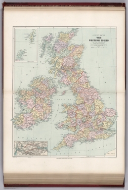
Author
[Stanford, Edward, Woodward, H.B.]
Full Title
Geological Map of the British Isles by Edward Best. Edward Best, Geological Survey.(in set) Orkney and Shetland Islands.
List No
0949.018
Note
Shows 27 geologic units.
Author
[Stanford, Edward, Woodward, H.B.]
Full Title
A County Map of the British Isles. (inset) Orkney and Shetland Islands.
List No
0949.019
Note
Shows 27 geologic units.
Author
[Gorkin, Aleksandr Fedorovich, Motylev, V.E.]
Full Title
Vulkanov i vulkanizma. (with) Mirovaya karta epitsentrov katastroficheskikh i razrushitel'nykh zemletriasenii. (to accompany) Bolshoi Sovietskii Atlas Mira. Moskva 1937.
List No
11008.035
Note
2 color maps on 2 sheets. Showing volcanoes and volcanic activity of the world, with map showing the world's epicenters of catastrophic and destructive earthquakes. Includes color coded reference.
Author
[Gorkin, Aleksandr Fedorovich, Motylev, V.E.]
Full Title
Geologicheskaia karta mira. (with) Mirovaia karta mestorozhdenii poleznykh iskopaemykh. (to accompany) Bolshoi Sovietskii Atlas Mira. Moskva 1937.
List No
11008.037
Note
2 color maps on 2 sheets with inset diagram. Showing geological features and mineral deposit of the world. Includes color coded reference.
Author
[Gorkin, Aleksandr Fedorovich, Motylev, V.E.]
Full Title
Karta magnitnykh sklonenii SSSR. (with) Seysmicheskaia karta SSSR. (to accompany) Bolshoi Sovietskii Atlas Mira. Moskva 1937.
List No
11008.103
Note
2 color maps on 2 sheets. Showing distribution of the magnetic declination and seismic activities in Soviet Union. Includes explanation and color coded reference.
Author
[Gorkin, Aleksandr Fedorovich, Motylev, V.E.]
Full Title
Geologicheskaia karta Evropeyskoy chasti SSSR. (inset) Zemlia Novaia. (to accompany) Bolshoi Sovietskii Atlas Mira. Moskva 1937.
List No
11008.107
Note
Color geological map of Russia in Europe on 2 sheets. Includes inset map, geological time table, explanation and color coded reference.
Author
[Gorkin, Aleksandr Fedorovich, Motylev, V.E.]
Full Title
Chetvertichnye oledeneniia yevropeyskoy chasti SSSR. (inset) Zemlia Novaia. (with) Geomorfologicheskaia karta yevropeyskoi chasti SSSR. (to accompany) Bolshoi Sovietskii Atlas Mira. Moskva 1937.
List No
11008.111
Note
2 color maps of European Russia on 2 sheets. Showing quaternary deposits and Geomorphological features. Includes inset map, text, explanation and color coded and numeric references.
Author
[Gorkin, Aleksandr Fedorovich, Motylev, V.E.]
Full Title
Geologicheskaia karta Kavkaza. (with) Geomorfologicheskaia karta Kavkaza. (to accompany) Bolshoi Sovietskii Atlas Mira. Moskva 1937.
List No
11008.113
Note
2 color maps of Caucasus on 2 sheets. Showing geological and Geomorphological features. Includes text, explanation and color coded references.
Author
[Gorkin, Aleksandr Fedorovich, Motylev, V.E.]
Full Title
Geologicheskaia karta Urala. (with) Poleznye iskopayemye Urala. (to accompany) Bolshoi Sovietskii Atlas Mira. Moskva 1937.
List No
11008.115
Note
2 color maps on 2 sheets. Showing geological and mineral resources of Ural Mountains. Includes color coded references and color diagram.
Author
Meyer, Joseph, 1796-1856
Full Title
Mittelamerica Mit Den Specialkarten Uber : Die Vulkanreihe von Guatemala, die Landengen von Tehuantepec, Nicaragua und Panama, und die Central Vulkane der Sud See. Stahlstich (Direction v. Kleinknecht) aus der Schweinfurter Geographischen Graviranstalt des Bibliographischen Instituts zu Hildburghausen, Amsterdam, Paris und Philadelphia. (in upper margin) Meyer's Zeitung Atlas. No. 91. (to accompany) Neuester Zeitungs-Atlas fur Alte und Neue Erdkunde. Herausgegeben von J. Meyer.
List No
11652.099
Note
Engraved outline hand color map, with six elevation profiles and 8 inset maps: Gran Lago di Nicaragua. Der Isthmus von Panama. Die Landenge von Tehuantepec und Goazaculaco. Galapagos. Hawaii Archipelagus oder Sandwich Inseln. Waihu, Ostern I. Mendanas Archipelag. Societaets Inseln. Freundschaftliche Inseln. Shows boundaries, cities and towns. Relief shown by hachures. Prime meridian is Paris.
Author
Marmocchi, Francesco Constantino, 1805-1858
Full Title
Geografia Fisica. Ordine naturale de terreni. (to accompany) Atlante di geografia universale ... Di F.C. Marmocchi. Firenze : per Vincenzo Batelli e Compagni 1842.
List No
11713.054
Note
Colored table of geological periods and geologic Formations.
Author
Marmocchi, Francesco Constantino, 1805-1858
Full Title
Geografia Fisica. Stato de Terreni Moderni, teriari ed Ammonici. (to accompany) Atlante di geografia universale ... Di F.C. Marmocchi. Firenze : per Vincenzo Batelli e Compagni 1842.
List No
11713.055
Note
Colored cross-section of the land and table. Showing 3 states of geological formations: I. Terreni Moderni. II. Terreni Teriari. III. Terreni Ammonici.
Author
Marmocchi, Francesco Constantino, 1805-1858
Full Title
Geografia Fisica. Stato deTerreni Emilisi. (to accompany) Atlante di geografia universale ... Di F.C. Marmocchi. Firenze : per Vincenzo Batelli e Compagni 1842.
List No
11713.056
Note
Colored cross-section of the land and table. Showing 3 state of geological formations: IV. Terreni Emilisi.
Author
Marmocchi, Francesco Constantino, 1805-1858
Full Title
Geografia Fisica. Stato de Terreni Agalisi e Piroidi. (to accompany) Atlante di geografia universale ... Di F.C. Marmocchi. Firenze : per Vincenzo Batelli e Compagni 1842.
List No
11713.057
Note
Colored cross-section of the land and table. Showing 3 state of geological formations: V. Tni. Agalisi . VI. Terr. Piroidi.
Author
Marmocchi, Francesco Constantino, 1805-1858
Full Title
Geografia Fisica. Stato del Globo nelle sue Diverse Eta. (to accompany) Atlante di geografia universale ... Di F.C. Marmocchi. Firenze : per Vincenzo Batelli e Compagni 1842.
List No
11713.058
Note
Colored cross-section of the interior structure of the Earth. Includes notes.
Author
Marmocchi, Francesco Constantino, 1805-1858
Full Title
Geografia Fisica. Idee di Alessandro Humboldt, e di Giuseppe Marzari - Pencati, sulla disposizione dei diversi terreni ond e formala la corteccia esplorata della terra ... (to accompany) Atlante di geografia universale ... Di F.C. Marmocchi. Firenze : per Vincenzo Batelli e Compagni 1842.
List No
11713.059
Note
Engraved 10 cross-section of the Earth's crust, with the geological time table. based on Alexnader von Humboldt and Giuseppe Marzari-Pencati's idea, presented by F.C. Marmocchi.
Author
Marmocchi, Francesco Constantino, 1805-1858
Full Title
Geografia Fisica. Geografia dei vulcani accesi ed estinti. (to accompany) Atlante di geografia universale ... Di F.C. Marmocchi. Firenze : per Vincenzo Batelli e Compagni 1842.
List No
11713.060
Note
Engraved hand colored map of the world. Showing active and extinct volcanoes in the world.
Author
[Ewald, Ludwig 1813-1881, Bauerkeller, Georg Leonhart]
Full Title
No. 11. Gliederung und Lagerungs verhaeltnisse der Gebirgsformationen.
List No
12189.033
Author
[Ewald, Ludwig 1813-1881, Bauerkeller, Georg Leonhart]
Full Title
No. 12. Deutschland ... Geognostische Ubersichtskarte.
List No
12189.034
Author
[Ewald, Ludwig 1813-1881, Bauerkeller, Georg Leonhart]
Full Title
No. 13. Veraenderungen der Erdoberflaeche in historischer Zeit.
List No
12189.035
Author
[Ewald, Ludwig 1813-1881, Bauerkeller, Georg Leonhart]
Full Title
No. 14. Die Gletscher der Alpen.
List No
12189.036
Note
Bottom edge shows a diagram with the lengths of the glaciers of the Alps.
Author
[Ewald, Ludwig 1813-1881, Bauerkeller, Georg Leonhart]
Full Title
No. 12. Deutschland und das Alpen-Gebiet ... Geognostische Uebersichtkarte.
List No
12189.116
Author
[Johnston, Alexander Keith, 1804-1871, Berghaus]
Full Title
The Phenomena of Volcanic Action Showing the Regions visited by Earthquakes and the Distribution of Volcanoes over the Globe. (insets) Principal Volcanic Series of the New World. Principal Volcanic Series of the Old World. Iceland. Sandwich Islands. Canary Islands. Greek Islands. Lower Italy.
List No
12509.030
Author
[Johnston, Alexander Keith, 1804-1871, von Bach, Leopold, von Humboldt, Alexander, Swinburne, C.H., Mueller, Salomon]
Full Title
Comparative Views of Remarkable Geological Phenomena. (insets) Island of Teneriffe. Vesuvius and Etna. South Keeling Islands. Crater of Cedee. Graham Island. Arthurs Seat. Ascension Island. Pichincha and Antisana.
List No
12509.034
Author
[Meyer, Herrmann Julius, 1826-1909., Ravenstein, Ludwig]
Full Title
Hohenschichten-Karte von Deutschland in 4 blattern. Bearbeitel von L. Ravenstein. L. Ravenstein dir. Corr. I. Bibliographischen Instituts zu Hildburghausen. Stich. v. F. Runge. (to accompany) Meyer's Hand-Atlas ... 1872.
List No
13324.018
Note
One of 4 sheets. Color map of the elevation layers of Germany, with inset: Ideales profil sur Erklaurung der Hohenschichten und deren Farben. Map showing mountain heights. Relief shown by gradient tints. Prime meridian is Ferro.
Author
[Meyer, Herrmann Julius, 1826-1909., Ravenstein, Ludwig]
Full Title
Hohenschichten-Karte von Deutschland, Nordostliches blatt. L. Ravenstein dir. Corr. I. Bibliographischen Instituts zu Hildburghausen. Stich. v. F. Runge. (to accompany) Meyer's Hand-Atlas ... 1872.
List No
13324.019
Note
Two of 4 sheets. Color map of the elevation layers of Germany, Northeast sheet, with inset: Ideales profil sur Erklaurung der Hohenschichten. Relief shown by gradient tints. Prime meridian is Ferro.
Author
[Meyer, Herrmann Julius, 1826-1909., Ravenstein, Ludwig]
Full Title
Hohenschichten-Karte von Deutschland, Sudwestliches blatt. L. Ravenstein dir. Corr. I. Bibliographischen Instituts zu Hildburghausen. Stich. v. F. Runge. (to accompany) Meyer's Hand-Atlas ... 1872.
List No
13324.020
Note
Three of 4 sheets. Color map of the elevation layers of Germany, Southwest sheet, with inset: Ideales profil sur Erklaurung der Hohenschichten. Relief shown by gradient tints. Prime meridian is Ferro.
Author
[Meyer, Herrmann Julius, 1826-1909., Ravenstein, Ludwig]
Full Title
Hohenschichten-Karte von Deutschland, Sudostliches blatt. L. Ravenstein dir. Corr. I. Bibliographischen Instituts zu Hildburghausen. Stich. v. F. Runge. (to accompany) Meyer's Hand-Atlas ... 1872.
List No
13324.021
Note
Four of 4 sheets. Color map of the elevation layers of Germany, Southeast sheet, with inset: Ideales profil sur Erklaurung der Hohenschichten. Relief shown by gradient tints. Prime meridian is Ferro.
Author
[Sydow, Emil von., 1812-1873, Wagner, Hermann, 1840-1929]
Full Title
Tektonik und Geologie der Erde. Gotha : Justus Perthes. Sydow-Wagners method. Schul-Atlas XXII.
List No
13558.023
Note
Tectonic map of the world, with 4 insets at the scale of 1:100,000,000: North America; South America; Africa; Australia and Indonesia. Showing principal tectonic regions. Includes color coded tectonic classification for continental and oceanic.
Author
[Sydow, Emil von., 1812-1873, Wagner, Hermann, 1840-1929]
Full Title
Europa : übersicht des relief. Gotha : Justus Perthes. Sydow-Wagners method. Schul-Atlas. XXII.
List No
13558.039
Note
Geologic map of Europe. Bonnesche projektion.
Author
[Sydow, Emil von., 1812-1873, Wagner, Hermann, 1840-1929]
Full Title
Europa : Geologie, Tektonic. Gotha : Justus Perthes. Sydow-Wagners method. Schul-Atlas. XXII.
List No
13558.041
Note
Geologic map of Europe, Bonnesche projektion. With inset map: Tektonische Karte. Includes color coded reference to rock formations and land features.
Author
[Sydow, Emil von., 1812-1873, Wagner, Hermann, 1840-1929]
Full Title
Mitteleuropa : Geologische Karte. Gotha : Justus Perthes. Sydow-Wagners method. Schul-Atlas. XXII.
List No
13558.054
Note
Geologic map of Central Europe. Vereinfachte Kegelprojektion. Includes color coded reference to rock formations and land features.
Author
[Sydow, Emil von., 1812-1873, Wagner, Hermann, 1840-1929]
Full Title
Mitteleuropa : Klima, Morphologie. Gotha : Justus Perthes. Sydow-Wagners method. Schul-Atlas. XXII.
List No
13558.057
Note
4 maps of Central Europe on 1 sheet, Vereinfachte Kegelprojektion. Showing the temperature and precipitation, and structure of the land surface.
Author
[Sydow, Emil von., 1812-1873, Wagner, Hermann, 1840-1929]
Full Title
Asien: Ubersicht des Reliefs, der politischen Verhaltnisse und Hauptverkehrswege. Gotha : Justus Perthes. Sydow-Wagners method. Schul-Atlas. XXII.
List No
13558.117
Note
Map of Asia. Showing relief, the political boundaries and main traffic routes. Bonne'sche Projektion.
Author
[Sydow, Emil von., 1812-1873, Wagner, Hermann, 1840-1929]
Full Title
Nordamerika : Sonderkarten zur Landerkunde. Gotha : Justus Perthes. Sydow-Wagners method. Schul-Atlas. XXII.
List No
13558.139
Note
10 maps on 1 sheet, in variable scale. Showing climate, industry, geological and soil condition in North America.
Author
[Sydow, Emil von., 1812-1873, Wagner, Hermann, 1840-1929]
Full Title
Mitteleuropa : Geologische Karte. Mitteleuropa : Geologische Karte. Gotha : Justus Perthes. Sydow-Wagners method. Schul-Atlas. XXIII.
List No
13559.054
Note
Geologic map of Central Europe. Vereinfachte Kegelprojektion. Includes color coded reference to rock formations and land features.
Author
[Sydow, Emil von., 1812-1873, Wagner, Hermann, 1840-1929]
Full Title
Mitteleuropa : Klima, Morphologie. Gotha : Justus Perthes. Sydow-Wagners method. Schul-Atlas. XXIII.
List No
13559.057
Note
4 maps of Central Europe on 1 sheet, Vereinfachte Kegelprojektion. Showing the temperature and precipitation, and structure of the land surface.
Author
[Sydow, Emil von., 1812-1873, Wagner, Hermann, 1840-1929]
Full Title
Asien: Ubersicht des Reliefs, der politischen Verhaltnisse und Hauptverkehrswege. Sydow-Wagners methodischer Sydow-Wagners method. Schul-Atlas. XXIII.
List No
13559.123
Note
Map of Asia. Showing relief, the political boundaries and main traffic routes. Bonne'sche Projektion.
Author
[Sydow, Emil von., 1812-1873, Wagner, Hermann, 1840-1929]
Full Title
Nordamerika : Sonderkarten zur Landerkunde. Gotha : Justus Perthes. Sydow-Wagners method. Schul-Atlas. XXIII.
List No
13559.147
Note
10 maps on 1 sheet, in variable scale. Showing climate, industry, geology and soil condition in North America.
Author
Stanford, Edward, 1827-1904
Full Title
9. A geological map of the British Isles. London: Edward Stanford, 55 Charing Cross, S.W. Stanford's Geographical Establishment.
List No
14053.067
Note
Geological map of the British Isles, in colored lithograph. Shows railways, drainage, and geological character of land. Includes a legend indicating geological periods (tertiary, cretaceous, jurassic, etc.), as well as two bar scales. With inset: Shetland Islands. 59 x 46 cm, on sheet 71 x 55 cm. In Vol. II.
Author
Imhof, Eduard, 1895-1986
Full Title
Geologie.
List No
14401.066
Note
Map of Europe, featuring geology, in 1969. Also shows bodies of water, drainage, coastlines, islands and water depths. Includes latitudinal and longitudinal lines, a legend, bar scale and scale statement. Colored lithograph. Map is 17 x 29 cm, on sheet 22 x 33 cm. Appears in section entitled Europa [= Europe].
Author
[Andree, Richard, Scobel, Albert]
Full Title
Mitteleuropa, Geologische Übersicht. Okt. 1905. Bearb. v. R. Kocher (die geolog. Formationen nach der internationalen Karte von Europa). Lithogr. v. W. Ketterer, O. Simon u. A. Wagner.
List No
1463.023
Note
Color map. Shows geologic formation and geologic timetable. Prime meridian is Greenwich.
Full Title
Vulkane und Koralleninseln. (Richard Andree. Herausgegeben von der Geographischen Anstalt von Velhagen & Klasing in Leipzig. 1881)
List No
1494.004
Note
Color map. Insets: Der Aetna -- Der Vesuv -- Pico de Teyde auf Teneriffa -- Mangarewa oder Gambier Id. -- Mount Wellington auf dem Isthmus v. Auckland in Neu-Seeland -- Santorin -- Nord-Friesland um 1240 und jetzt. Includes 3 sections.
Author
Hammond, C.S.
Full Title
Resource-Relief Map of North America. 1415. Resource-Relief Map of South America. 3415. Resource-Relief Map of Africa. 2415. Resource-Relief Map of Asia. 5415.
List No
1954.007
Note
Set of four black and white maps titled separately.
Author
Hammond, C.S.
Full Title
Iron. Coal. Petroleum. Tin and Copper. Tobacco and Cocoa. Strategic Minerals. Self-Sufficiency in Raw Materials. Maps of Comparative Geography. Europe. Australia and New Zealand.
List No
1954.012
Note
Six black and white maps. One diagram. Eight color maps. Comparative geography covered vegetation, population distribution, physical, and climate.
Author
[Instituto Geographico di Agostini, Bayer, Herbert]
Full Title
Elementi di Geologia.
List No
2170.004
Note
Elements of geology and geomorphology shown.
Author
[Instituto Geographico di Agostini, Bayer, Herbert]
Full Title
Plisfero Tettonico.
List No
2170.005
Note
Elements of tectonics, seismicity, glaciation, and vulcanology shown.
Author
[Instituto Geographico di Agostini, Bayer, Herbert]
Full Title
Europa.
List No
2170.024
Note
Eight maps of Europe showing tectonics, geology, climate, peoples, and population.
Author
[Instituto Geographico di Agostini, Bayer, Herbert]
Full Title
Italia Fisica. (insets) Geologia and Densita di Popolazione.
List No
2170.027
Note
Relief shown as combined hachures, shaded relief, and hypsometric tints; bathymetry also tinted.
Author
Society for the Diffusion of Useful Knowledge (Great Britain)
Full Title
Geological Map of England and Wales.
List No
2326.010
Author
[Campbell, R.A., Worthen, Amos Henry, 1813-1888]
Full Title
Worthens new geological map of Illinois. Prepared expressly for Campbell's Illinois atlas. (Drawn by R.A. Campbell and H.F. Walling). Entered ... 1869 by R.A. Campbell ... Pennsylvania. (1870)
List No
2483.089
Note
Hand colored map. Shows 8 geologic units (Tertiary, Coal measures, Lower Carboniferous, Devonian, Upper Silurian, Cincinnati Group, Trenton Limestone and Calciferous Group). Prime meridians: Greenwich and Washington.
Author
Berghaus, Heinrich
Full Title
Europa in Geologischer Beziehung nach den Hauptmassen der Gebirgs-Formationen. 3te Abtheilung: Geologie, No. 4. Gotha, bei J. Perthes. 1843.
List No
2515.031
Note
A geologic map of Europe showing active volcanoes, and the oldest and newest mountain ranges on the continent. In full color.
Author
Berghaus, Heinrich
Full Title
Die Vulkanischen Erscheinungen Der Atlen Welt, In Und Um Den Atlantischen Ocean. 3te Abtheilung: Geologie, No. 7. Potsdam, gestochen in der geographischen Kunstschule. Gotha, bei J. Perthes, 1839.
List No
2515.034
Note
Map shows the range of volcanic and earthquake activity throughout the world. In outline color are three different earthquake regions with dates of activity ranging from 1755-1838.
Author
Berghaus, Heinrich
Full Title
Specialia vom Vulkan Gurtel des Atlantischen Oceans. 3te Abtheilung: Geologie, No. 8. Gezeichnet von F. Schelle. Gestochen von Joh. Carl Ausfeld. Gotha, J. Perthes, 1839.
List No
2515.035
Note
Thirteen maps showing volcanic activity throughout the Atlantic and Mediterranean Oceans. Detailed outline colored maps are accompanied by drawings of exploding volcanoes, calderas, and volcanic mountain ranges.
Author
Berghaus, Heinrich
Full Title
Karte von dem Vulkan Gurtel und dem Central Gruppen des Grossen Oceans; nach Leopold v. Buch; von Berghaus. Potsdam, 16 Juli 1838. 3te Abtheilung: Geologie, No. 9. Gezeichnet von F. Schelle. In Potsdam Gestochen von K. Kolbe. Gotha, J. Perthes, 1838.
List No
2515.036
Note
Map of the Pacific Ocean showing volcanic and earthquake activity. Circled regions of activity include the Philippines and Central America. In outline color.
Author
Berghaus, Heinrich
Full Title
Die Vulkanreihe von Guatemala, die Landengen von Tehuantepec, Nicaragua und Panama, und die Central Vulkane der Sud See. 3te Abtheilung: Geologie, No. 10. Potsdam, gez. u. gest. in der geogr. Kunstschule. Gotha, bei J. Perthes, 1840.
List No
2515.037
Note
Maps in outline color. Main map is of Central America. Nine inset maps detail the volcanic regions of Central America and the islands in the Pacific Ocean and South Seas. Side views of Costa Rica, Guatemala, and the isthmus of Tehuantepec are included.
Author
Berghaus, Heinrich
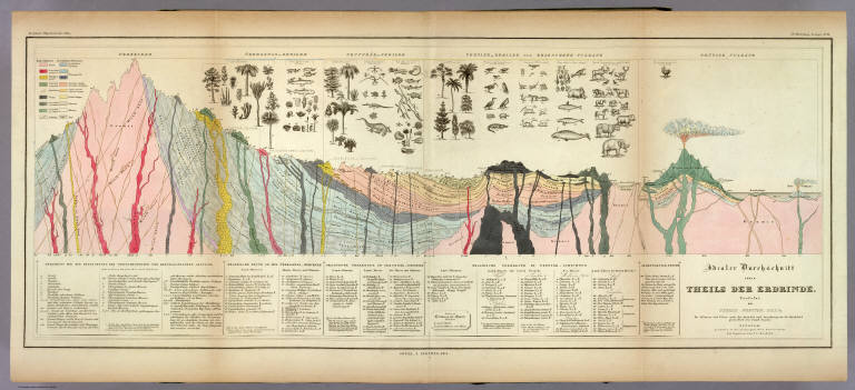
Full Title
Idealer Durchschnitt eines Theils Der Erdrinde. Verfafst von Thomas Webster, F.G.S. &c. Die Pflanzen und Thiere nach der Auswahl und Anordnung des Dr. Buckland gezeichnet von Joseph Fischer. Potsdam, gestochen in der geographischen Kunstschule, die Figuren von J.C. Ausfeld. 3te Abtheilung: Geologie, No. 11. Gotha, J. Perthes, 1841.
List No
2515.038
Note
A full color "ideal" geologic cross section with a detailed key explaining all of the notations on the map. Above the section are numerous drawings of plants, animals, and sea life.
Author
Berghaus, Heinrich
Full Title
Geologische Karte von Deutschland und den anlieg. Landern nach des Bergmeister's H. Credner Zusamenstellung. 1843. 3te Abtheilung: Geologie, No. 12. Gotha, bei J. Perthes.
List No
2515.039
Note
A full color geologic map of Germany accompanied by two keys.
Author
Berghaus, Heinrich
Full Title
Spezial-Karte vom Riesen-Gebirge. 3te Abtheilung: Geologie, No. 13. Gezeichnet u. gestochen in der geogr. Kunstschule zu Potsdam. Gotha, J. Perthes, 1843.
List No
2515.040
Note
Geologic map of the Reisengebirge (or Krkonose, Karkonosze or Giant Mountains) in the Czech Republic and Poland.
Author
Berghaus, Heinrich
Full Title
Geologische Profile von Deutschland im Allgemeinen u. von Riesengebirge im Besondern; Sammt Einer Karte vom Tertiar Becken von Paris. 3te Abtheil: Geologie, No. 14. Gezeichnet von H. Credner. Gest. v. E.G. Edler. Gotha, bei J. Perthes, 1845.
List No
2515.041
Note
A full color geologic map of France and numerous full color geologic cross sections of Germany. A key is included.
Author
Berghaus, Heinrich
Full Title
Vermischtes zur Geologie. 3te Abtheilung: Geologie, No. 15. Potsdam, gez. u. gest. in der geogr. Kunstschule. Gotha, bei J. Perthes, 1844.
List No
2515.042
Note
Miscellaneous geological maps, charts, and information. Some color. Maps include the Quito Plateau, the Himalayas, and the crater on Java. The heights of the Himalayan mountains are shown.
Author
[Drioux, Claude-Joseph, Leroy, Charles]
Full Title
France : Hypsometrique : Relief du sol. Par M.Mrs. Drioux et Ch. Leroy. Dessine par Vilpou. ... Grave par F. Dufour. Librairie Classique Eugene Belin Paris. (inset) Corse. (to accompany) Atlas Universel Et Classique De Geographie ...1886. (insets) France geologique . (with inset) Corse; Coupe ideale de l'ecorce terrestre.
List No
3277.032
Note
Color hypsometric and geologic map of France. Includes cross section of the earth's crust. Relief shown by gradient tints and spot heights. Shows terrains, rivers, mountains, etc.
Author
[Gray, Ormando Willis, Hitchcock, Charles H. (Charles Henry), 1836-1919]
Full Title
Gray's Geological Map of the United States by Charles H. Hitchcock PhD, Professor of Geology in Dartmouth College. Philadelphia: O.W. Gray & SOn.
List No
3888.070
Note
Prime meridians Washington D.C. and Greenwich. Relief shown by hachures.
Author
[Brue, Adrien Hubert, 1786-1832, Levasseur, E.]
Full Title
Mappemonde projectee sur l'Horizon de Paris et de Antipode. Mappemonde sur la Projection Polaire. Dresse par A. Brue, Geographe. Reoue par E. Levasseur, Membre de l'Institut, Institut Geographique de Paris. Ch. Delagrave. Editeurs de la Societe de Geographie. 58 Rue des Ecoles. Atlas Universel en 67 feuilles No. 18.
List No
4607.018
Note
Two sets of hemispheres; one map of geology with hemispheres centered on Paris and its antipode; second map in polar projection showing watersheds of oceans. Relief shown by hachures.
Author
Arrowsmith, John
Full Title
The Inland Navigation, Rail Roads, Geology and Minerals of England & Wales, By J. Arrowsmith. (Map) 5. London, Pubd. 15 Feby. 1842, by J. Arrowsmith, 10 Soho Square.
List No
4613.005
Note
Note on map states: "For the list of the several Geological Groups, and Divisions in this map, I have been principally indebted to the splendid Geological Map of England and Wales, by G.B. Greenough Esqr. F.G.S." In full color. Legend shows the geological groups on the map. Four sections of the line of navigation included.
Author
Gray, Ormando Willis
Full Title
Gray's Atlas Map of the United States Showing the Principal Geological Formations by Cha's. H. Hitchcock, Ph.D.,Professor of Geology in Dartmouth College.
List No
4740.011
Note
Prime meridians Washington D.C. and Greenwich. Relief shown by hachures.
Author
Dussieux, L.
Full Title
64. Croquis d'une Carte Geologique de la France.
List No
4759.064
Note
Full color.
Author
[Dechen, H. von (Heinrich), 1800-1889, Hughes, William, 1817-1876, Meyer, Joseph, 1796-1856]
Full Title
Geognostische Karte von Central- und West-Europa einschlieslich der Britischen Inseln, Frankreich, Deutschland und der Nachbarlander. Mit Zugrundlage der Karte von Dr. H. von Dechen, Professor der Berliner Universitat, und der Werke der eminentesten europaischen Geologen, entworfen von W. Hughes, F.R.G.S. mit verbesserungen u. Berichtigungen von J. Meyer. 1844. Gez. v. Jos. Graessl. Stich, Druck und Verlag des Bibliographischen Instituts zu Hildburghausen, (1860)
List No
4807.011
Note
Engraved map on 2 sheets. Geologic units hand col. Relief shown by spot heights. Inset map: Forsetzung von Schottland. Some place names and geologic units also in English. Contents: I. Westl. Haelfte -- II. Oestl. Haelfte. Titles in margin: Geognostische Karte v. Mittel-Europa. "Meyer's Handatlas No. 29 ... 30." David Rumsey Collection copy mounted as 1 sheet.
Author
Johnson, A.J.
Full Title
Johnson's World, Showing the Distribution of the Characteristic Forest Trees, Principal Useful Plants and Minerals. By Prof. A. Guyot. Published by A. J. Johnson, New York. 13. Entered according to the Act of Congress, in the year 1870, by A.J. Johnson in the Clerk's Office of the District Court of the United States for the Southern District of New York.
List No
4828.018
Note
Engraved color map, and two insets of mineral distributions.
Author
Johnson, Alvin Jewett, 1827-1884.
Full Title
Johnson's physical map, showing the principal mountains, plateaus & plains of the world. No. I. By Prof. A. Guyot. Published by A.J. Johnson & Son N.Y. (inset profiles) comparative altitude of principal mountains and tablelands of the World. Johnson's world, showing the lines of equal magnetic declination. Epoch 1858. No. II. Johnson's world, showing the course of the tidal-wave in the three great oceans, and distribution of volcanoes. No. III. Johnson's world, showing the distribution of the principal races of man. By Prof. A. Guyot. Entered ... 1870, by A.J. Johnson ... New York. (to accompany) Johnson's New Illustrated Family Atlas Of The World ... MDCCCLXXX (1880).
List No
4830.057
Note
4 physical maps of the world on 1 sheet, 64x44. No. I: 31x42, showing lowlands, highlands and highest lands. Relief shown by hachures. Includes legend and inset profiles. Accompanied by three maps No. II-IV:41.5x28.5, showing world's races, ocean current and volcanoes, and magnetic declination.
Author
[Best, Edward, Edward Stanford Ltd., Stanford, Edward]
Full Title
Geological map of the British Isles by Edward Best. Edward Best, Geological Survey. London atlas series. Stanford's Geographical Establishment. London : Edward Stanford, 12, 13 & 14 Long Acre, W.C. (1901)
List No
5075.010
Note
Full color. Shows 27 geologic units. Includes inset of the Shetland and Orkney islands. "VIII.87, XI.93."
Author
[Bristow, Henry W., Letts, Son & Co.]
Full Title
Geological map of England & Wales, with leading railways by Henry W. Bristow, F.R.S., F.G.S., Director of the Geological Survey of England and Wales. Letts's popular atlas. Letts, Son & Co. Limited, London. (1883)
List No
5371.007
Note
Colored map. Includes descriptive notes and explanation.
Author
Letts, Son & Co.
Full Title
Geological map of the environs of London. Letts's popular atlas. Letts, Son & Co. Limited, London. (1883)
List No
5371.015
Note
Colored map. Relief shown by hachures. Shows railroads, radial distances from Charing Cross, explanation, etc. "This map can be purchased separately, mounted on a board and varnished for 2/6, or backed with the "Orographical Map" for 3/6.
|