|
REFINE
Browse All : Geology and Separate Map
1-217 of 217
Author
[Geological Survey (U.S.), Conant, Louis C., Goudarzi, Gus H.]
Full Title
Geologic map of the Kingdom of Libya = خريطة جيولوجية للمملكة الليبية = Kharīṭah jiyūlūjīyah lil-Mamlakah al-Lībyah. Compiled by Louis C. Conant and Gus H. Goudarzi under the joint sponsership of the Kingdom of Libya and the Agency for International Development, U. S. Department of State. 1964. Department of Interior, United States Geological Survey. Kingdom of Libya. Ministries of National Economy, Petroleum Affairs, and Industry. Miscellaneous Geological Investigations, Map 1-350 A.
List No
13541.002
Note
Color geological map of Libya. Published by the U.S. Geological Survey, Washington, D.C., 1964.
Author
[Verbeek, Rogier Diederik Marius (1845 - 1926), Fennema, Reinder (1849 – 1897)]
Full Title
(Composite map of) A. I - D. X Geologische kaart van Java en Madoera in 26 Bladen. Opgenomen door de Hoofdingenieurs van het Mijnwezen Dr. R.D.M. Verbeek en R. Fennema met medewerking van de Topografen J.G. de Groot en M.H.A. Voorsmit, de Opzieners bij het Mijnwezen J.F. de Corte en H.P.J. Naumann en den teekenaar A.L.E. Gaston in de jaren 1886-1894.
List No
15561.030
Author
[Stöcklin, J., Nabavi, M. H., Sazman-i Zaminshinasi-i Kishvar Cartographic Section]
Full Title
Tectonic map of Irān
List No
15726.001
Author
[Verbeek, Rogier Diederik Marius (1845 - 1926), Fennema, Reinder (1849 – 1897)]
Full Title
(Title page to) Geologische kaart van Java en Madoera in 26 Bladen. Opgenomen door de Hoofdingenieurs van het Mijnwezen Dr. R.D.M. Verbeek en R. Fennema met medewerking van de Topografen J.G. de Groot en M.H.A. Voorsmit, de Opzieners bij het Mijnwezen J.F. de Corte en H.P.J. Naumann en den teekenaar A.L.E. Gaston in de jaren 1886-1894.
List No
15561.001
Author
[Verbeek, Rogier Diederik Marius (1845 - 1926), Fennema, Reinder (1849 – 1897)]
Full Title
(Composite map of) A. I - D. X Geologische kaart van Java en Madoera in 26 Bladen. Opgenomen door de Hoofdingenieurs van het Mijnwezen Dr. R.D.M. Verbeek en R. Fennema met medewerking van de Topografen J.G. de Groot en M.H.A. Voorsmit, de Opzieners bij het Mijnwezen J.F. de Corte en H.P.J. Naumann en den teekenaar A.L.E. Gaston in de jaren 1886-1894.
List No
15561.029
Author
[Verbeek, Rogier Diederik Marius (1845 - 1926), Fennema, Reinder (1849 – 1897)]
Full Title
(Keysheet to) Geologische kaart van Java en Madoera in 26 Bladen. Opgenomen door de Hoofdingenieurs van het Mijnwezen Dr. R.D.M. Verbeek en R. Fennema met medewerking van de Topografen J.G. de Groot en M.H.A. Voorsmit, de Opzieners bij het Mijnwezen J.F. de Corte en H.P.J. Naumann en den teekenaar A.L.E. Gaston in de jaren 1886-1894.
List No
15561.002
Author
[Verbeek, Rogier Diederik Marius (1845 - 1926), Fennema, Reinder (1849 – 1897)]
Full Title
A. I Geologische kaart van Java en Madoera in 26 Bladen. Opgenomen door de Hoofdingenieurs van het Mijnwezen Dr. R.D.M. Verbeek en R. Fennema met medewerking van de Topografen J.G. de Groot en M.H.A. Voorsmit, de Opzieners bij het Mijnwezen J.F. de Corte en H.P.J. Naumann en den teekenaar A.L.E. Gaston in de jaren 1886-1894.
List No
15561.003
Author
[Verbeek, Rogier Diederik Marius (1845 - 1926), Fennema, Reinder (1849 – 1897)]
Full Title
A. II Geologische kaart van Java en Madoera in 26 Bladen. Opgenomen door de Hoofdingenieurs van het Mijnwezen Dr. R.D.M. Verbeek en R. Fennema met medewerking van de Topografen J.G. de Groot en M.H.A. Voorsmit, de Opzieners bij het Mijnwezen J.F. de Corte en H.P.J. Naumann en den teekenaar A.L.E. Gaston in de jaren 1886-1894.
List No
15561.004
Author
[Verbeek, Rogier Diederik Marius (1845 - 1926), Fennema, Reinder (1849 – 1897)]
Full Title
A.III Geologische kaart van Java en Madoera in 26 Bladen. Opgenomen door de Hoofdingenieurs van het Mijnwezen Dr. R.D.M. Verbeek en R. Fennema met medewerking van de Topografen J.G. de Groot en M.H.A. Voorsmit, de Opzieners bij het Mijnwezen J.F. de Corte en H.P.J. Naumann en den teekenaar A.L.E. Gaston in de jaren 1886-1894.
List No
15561.005
Author
[Verbeek, Rogier Diederik Marius (1845 - 1926), Fennema, Reinder (1849 – 1897)]
Full Title
A. IV Geologische kaart van Java en Madoera in 26 Bladen. Opgenomen door de Hoofdingenieurs van het Mijnwezen Dr. R.D.M. Verbeek en R. Fennema met medewerking van de Topografen J.G. de Groot en M.H.A. Voorsmit, de Opzieners bij het Mijnwezen J.F. de Corte en H.P.J. Naumann en den teekenaar A.L.E. Gaston in de jaren 1886-1894.
List No
15561.006
Author
[Verbeek, Rogier Diederik Marius (1845 - 1926), Fennema, Reinder (1849 – 1897)]
Full Title
A. VI en A. VII Geologische kaart van Java en Madoera in 26 Bladen. Opgenomen door de Hoofdingenieurs van het Mijnwezen Dr. R.D.M. Verbeek en R. Fennema met medewerking van de Topografen J.G. de Groot en M.H.A. Voorsmit, de Opzieners bij het Mijnwezen J.F. de Corte en H.P.J. Naumann en den teekenaar A.L.E. Gaston in de jaren 1886-1894.
List No
15561.007
Author
[Verbeek, Rogier Diederik Marius (1845 - 1926), Fennema, Reinder (1849 – 1897)]
Full Title
B. I Geologische kaart van Java en Madoera in 26 Bladen. Opgenomen door de Hoofdingenieurs van het Mijnwezen Dr. R.D.M. Verbeek en R. Fennema met medewerking van de Topografen J.G. de Groot en M.H.A. Voorsmit, de Opzieners bij het Mijnwezen J.F. de Corte en H.P.J. Naumann en den teekenaar A.L.E. Gaston in de jaren 1886-1894.
List No
15561.008
Author
[Verbeek, Rogier Diederik Marius (1845 - 1926), Fennema, Reinder (1849 – 1897)]
Full Title
B. II en C. II Geologische kaart van Java en Madoera in 26 Bladen. Opgenomen door de Hoofdingenieurs van het Mijnwezen Dr. R.D.M. Verbeek en R. Fennema met medewerking van de Topografen J.G. de Groot en M.H.A. Voorsmit, de Opzieners bij het Mijnwezen J.F. de Corte en H.P.J. Naumann en den teekenaar A.L.E. Gaston in de jaren 1886-1894.
List No
15561.009
Author
[Verbeek, Rogier Diederik Marius (1845 - 1926), Fennema, Reinder (1849 – 1897)]
Full Title
B. III Geologische kaart van Java en Madoera in 26 Bladen. Opgenomen door de Hoofdingenieurs van het Mijnwezen Dr. R.D.M. Verbeek en R. Fennema met medewerking van de Topografen J.G. de Groot en M.H.A. Voorsmit, de Opzieners bij het Mijnwezen J.F. de Corte en H.P.J. Naumann en den teekenaar A.L.E. Gaston in de jaren 1886-1894.
List No
15561.010
Author
[Verbeek, Rogier Diederik Marius (1845 - 1926), Fennema, Reinder (1849 – 1897)]
Full Title
B. IV Geologische kaart van Java en Madoera in 26 Bladen. Opgenomen door de Hoofdingenieurs van het Mijnwezen Dr. R.D.M. Verbeek en R. Fennema met medewerking van de Topografen J.G. de Groot en M.H.A. Voorsmit, de Opzieners bij het Mijnwezen J.F. de Corte en H.P.J. Naumann en den teekenaar A.L.E. Gaston in de jaren 1886-1894.
List No
15561.011
Author
[Verbeek, Rogier Diederik Marius (1845 - 1926), Fennema, Reinder (1849 – 1897)]
Full Title
B. V Geologische kaart van Java en Madoera in 26 Bladen. Opgenomen door de Hoofdingenieurs van het Mijnwezen Dr. R.D.M. Verbeek en R. Fennema met medewerking van de Topografen J.G. de Groot en M.H.A. Voorsmit, de Opzieners bij het Mijnwezen J.F. de Corte en H.P.J. Naumann en den teekenaar A.L.E. Gaston in de jaren 1886-1894.
List No
15561.012
Author
[Verbeek, Rogier Diederik Marius (1845 - 1926), Fennema, Reinder (1849 – 1897)]
Full Title
B. VI Geologische kaart van Java en Madoera in 26 Bladen. Opgenomen door de Hoofdingenieurs van het Mijnwezen Dr. R.D.M. Verbeek en R. Fennema met medewerking van de Topografen J.G. de Groot en M.H.A. Voorsmit, de Opzieners bij het Mijnwezen J.F. de Corte en H.P.J. Naumann en den teekenaar A.L.E. Gaston in de jaren 1886-1894.
List No
15561.013
Author
[Verbeek, Rogier Diederik Marius (1845 - 1926), Fennema, Reinder (1849 – 1897)]
Full Title
B. VII Geologische kaart van Java en Madoera in 26 Bladen. Opgenomen door de Hoofdingenieurs van het Mijnwezen Dr. R.D.M. Verbeek en R. Fennema met medewerking van de Topografen J.G. de Groot en M.H.A. Voorsmit, de Opzieners bij het Mijnwezen J.F. de Corte en H.P.J. Naumann en den teekenaar A.L.E. Gaston in de jaren 1886-1894.
List No
15561.014
Author
[Verbeek, Rogier Diederik Marius (1845 - 1926), Fennema, Reinder (1849 – 1897)]
Full Title
B. VIII Geologische kaart van Java en Madoera in 26 Bladen. Opgenomen door de Hoofdingenieurs van het Mijnwezen Dr. R.D.M. Verbeek en R. Fennema met medewerking van de Topografen J.G. de Groot en M.H.A. Voorsmit, de Opzieners bij het Mijnwezen J.F. de Corte en H.P.J. Naumann en den teekenaar A.L.E. Gaston in de jaren 1886-1894.
List No
15561.015
Author
[Verbeek, Rogier Diederik Marius (1845 - 1926), Fennema, Reinder (1849 – 1897)]
Full Title
B. IX Geologische kaart van Java en Madoera in 26 Bladen. Opgenomen door de Hoofdingenieurs van het Mijnwezen Dr. R.D.M. Verbeek en R. Fennema met medewerking van de Topografen J.G. de Groot en M.H.A. Voorsmit, de Opzieners bij het Mijnwezen J.F. de Corte en H.P.J. Naumann en den teekenaar A.L.E. Gaston in de jaren 1886-1894.
List No
15561.016
Author
[Verbeek, Rogier Diederik Marius (1845 - 1926), Fennema, Reinder (1849 – 1897)]
Full Title
B. X Geologische kaart van Java en Madoera in 26 Bladen. Opgenomen door de Hoofdingenieurs van het Mijnwezen Dr. R.D.M. Verbeek en R. Fennema met medewerking van de Topografen J.G. de Groot en M.H.A. Voorsmit, de Opzieners bij het Mijnwezen J.F. de Corte en H.P.J. Naumann en den teekenaar A.L.E. Gaston in de jaren 1886-1894.
List No
15561.017
Author
[Verbeek, Rogier Diederik Marius (1845 - 1926), Fennema, Reinder (1849 – 1897)]
Full Title
C. III Geologische kaart van Java en Madoera in 26 Bladen. Opgenomen door de Hoofdingenieurs van het Mijnwezen Dr. R.D.M. Verbeek en R. Fennema met medewerking van de Topografen J.G. de Groot en M.H.A. Voorsmit, de Opzieners bij het Mijnwezen J.F. de Corte en H.P.J. Naumann en den teekenaar A.L.E. Gaston in de jaren 1886-1894.
List No
15561.018
Author
[Verbeek, Rogier Diederik Marius (1845 - 1926), Fennema, Reinder (1849 – 1897)]
Full Title
C. IV Geologische kaart van Java en Madoera in 26 Bladen. Opgenomen door de Hoofdingenieurs van het Mijnwezen Dr. R.D.M. Verbeek en R. Fennema met medewerking van de Topografen J.G. de Groot en M.H.A. Voorsmit, de Opzieners bij het Mijnwezen J.F. de Corte en H.P.J. Naumann en den teekenaar A.L.E. Gaston in de jaren 1886-1894.
List No
15561.019
Author
[Verbeek, Rogier Diederik Marius (1845 - 1926), Fennema, Reinder (1849 – 1897)]
Full Title
C. V Geologische kaart van Java en Madoera in 26 Bladen. Opgenomen door de Hoofdingenieurs van het Mijnwezen Dr. R.D.M. Verbeek en R. Fennema met medewerking van de Topografen J.G. de Groot en M.H.A. Voorsmit, de Opzieners bij het Mijnwezen J.F. de Corte en H.P.J. Naumann en den teekenaar A.L.E. Gaston in de jaren 1886-1894.
List No
15561.020
Author
[Verbeek, Rogier Diederik Marius (1845 - 1926), Fennema, Reinder (1849 – 1897)]
Full Title
C. VI Geologische kaart van Java en Madoera in 26 Bladen. Opgenomen door de Hoofdingenieurs van het Mijnwezen Dr. R.D.M. Verbeek en R. Fennema met medewerking van de Topografen J.G. de Groot en M.H.A. Voorsmit, de Opzieners bij het Mijnwezen J.F. de Corte en H.P.J. Naumann en den teekenaar A.L.E. Gaston in de jaren 1886-1894.
List No
15561.021
Author
[Verbeek, Rogier Diederik Marius (1845 - 1926), Fennema, Reinder (1849 – 1897)]
Full Title
C. VII en D. VII Geologische kaart van Java en Madoera in 26 Bladen. Opgenomen door de Hoofdingenieurs van het Mijnwezen Dr. R.D.M. Verbeek en R. Fennema met medewerking van de Topografen J.G. de Groot en M.H.A. Voorsmit, de Opzieners bij het Mijnwezen J.F. de Corte en H.P.J. Naumann en den teekenaar A.L.E. Gaston in de jaren 1886-1894.
List No
15561.022
Author
[Verbeek, Rogier Diederik Marius (1845 - 1926), Fennema, Reinder (1849 – 1897)]
Full Title
C. VIII Geologische kaart van Java en Madoera in 26 Bladen. Opgenomen door de Hoofdingenieurs van het Mijnwezen Dr. R.D.M. Verbeek en R. Fennema met medewerking van de Topografen J.G. de Groot en M.H.A. Voorsmit, de Opzieners bij het Mijnwezen J.F. de Corte en H.P.J. Naumann en den teekenaar A.L.E. Gaston in de jaren 1886-1894.
List No
15561.023
Author
[Verbeek, Rogier Diederik Marius (1845 - 1926), Fennema, Reinder (1849 – 1897)]
Full Title
C. IX Geologische kaart van Java en Madoera in 26 Bladen. Opgenomen door de Hoofdingenieurs van het Mijnwezen Dr. R.D.M. Verbeek en R. Fennema met medewerking van de Topografen J.G. de Groot en M.H.A. Voorsmit, de Opzieners bij het Mijnwezen J.F. de Corte en H.P.J. Naumann en den teekenaar A.L.E. Gaston in de jaren 1886-1894.
List No
15561.024
Author
[Verbeek, Rogier Diederik Marius (1845 - 1926), Fennema, Reinder (1849 – 1897)]
Full Title
C. X Geologische kaart van Java en Madoera in 26 Bladen. Opgenomen door de Hoofdingenieurs van het Mijnwezen Dr. R.D.M. Verbeek en R. Fennema met medewerking van de Topografen J.G. de Groot en M.H.A. Voorsmit, de Opzieners bij het Mijnwezen J.F. de Corte en H.P.J. Naumann en den teekenaar A.L.E. Gaston in de jaren 1886-1894.
List No
15561.025
Author
[Verbeek, Rogier Diederik Marius (1845 - 1926), Fennema, Reinder (1849 – 1897)]
Full Title
D. VIII Geologische kaart van Java en Madoera in 26 Bladen. Opgenomen door de Hoofdingenieurs van het Mijnwezen Dr. R.D.M. Verbeek en R. Fennema met medewerking van de Topografen J.G. de Groot en M.H.A. Voorsmit, de Opzieners bij het Mijnwezen J.F. de Corte en H.P.J. Naumann en den teekenaar A.L.E. Gaston in de jaren 1886-1894.
List No
15561.026
Author
[Verbeek, Rogier Diederik Marius (1845 - 1926), Fennema, Reinder (1849 – 1897)]
Full Title
D. IX Geologische kaart van Java en Madoera in 26 Bladen. Opgenomen door de Hoofdingenieurs van het Mijnwezen Dr. R.D.M. Verbeek en R. Fennema met medewerking van de Topografen J.G. de Groot en M.H.A. Voorsmit, de Opzieners bij het Mijnwezen J.F. de Corte en H.P.J. Naumann en den teekenaar A.L.E. Gaston in de jaren 1886-1894.
List No
15561.027
Author
[Verbeek, Rogier Diederik Marius (1845 - 1926), Fennema, Reinder (1849 – 1897)]
Full Title
D. X Geologische kaart van Java en Madoera in 26 Bladen. Opgenomen door de Hoofdingenieurs van het Mijnwezen Dr. R.D.M. Verbeek en R. Fennema met medewerking van de Topografen J.G. de Groot en M.H.A. Voorsmit, de Opzieners bij het Mijnwezen J.F. de Corte en H.P.J. Naumann en den teekenaar A.L.E. Gaston in de jaren 1886-1894.
List No
15561.028
Author
Jenkins, Olaf P.
Full Title
Sheet No. I Northern Section. Geologic Map of California Prepared by Olaf P. Jenkins Chief Geologist, Geologic Branch
List No
15485.001
Note
Dimensions are sheet size.
Author
Jenkins, Olaf P.
Full Title
Sheet No. II Central Section. Geologic Map of California Prepared by Olaf P. Jenkins Chief Geologist, Geologic Branch
List No
15485.002
Note
Dimensions are sheet size.
Author
Jenkins, Olaf P.
Full Title
Sheet No. III Southwest Coast Section. Geologic Map of California Prepared by Olaf P. Jenkins Chief Geologist, Geologic Branch.
List No
15485.003
Note
Dimensions are sheet size.
Author
Jenkins, Olaf P.
Full Title
Sheet No. IV Geologic Legend. Geologic Map of California Prepared by Olaf P. Jenkins Chief Geologist, Geologic Branch.
List No
15485.004
Note
Dimensions are sheet size.
Author
Jenkins, Olaf P.
Full Title
Sheet No. V East-Central Section. Geologic Map of California Prepared by Olaf P. Jenkins Chief Geologist, Geologic Branch.
List No
15485.005
Note
Dimensions are sheet size.
Author
Jenkins, Olaf P.
Full Title
Sheet No. VI Southern Section. Geologic Map of California Prepared by Olaf P. Jenkins Chief Geologist, Geologic Branch.
List No
15485.006
Note
Dimensions are sheet size.
Author
Jenkins, Olaf P.
Full Title
(Composite map of) Sections I-VI. Geologic Map of California Prepared by Olaf P. Jenkins Chief Geologist, Geologic Branch
List No
15485.007
Note
Dimensions are sheet size.
Author
[Shikhelibeyli [Shiklinski], E. Sh., Memmedov, E. V.]
Full Title
SSSRI Nazirlər Soveti Yaninda Bas Geodeziya və Kartoqrafiya Idarəsi [i.e. The Chief Administration of Geodesy and Cartography Under the Council of Ministers of the USSR]
List No
15271.000
Author
[Shikhelibeyli [Shiklinski], E. Sh., Memmedov, E. V.]
Full Title
SSSRI Nazirlər Soveti Yaninda Bas Geodeziya və Kartoqrafiya Idarəsi [i.e. The Chief Administration of Geodesy and Cartography Under the Council of Ministers of the USSR]
List No
15272.000
Author
[Humboldt, Alexander von, 1769-1859, Bonpland, Aime (1773-1858)]
Full Title
Geographie des Plantes Equinoxiales. Tableau Physique des Andes et Pays voisins, dresse d'apres des observations et des mesures prises sur les lieux depuis le 10(degree) degre de latitude boreale jusquau 10(degree) de latitude australe en 1799, 1800, 1801, 1802 et 1803. Par Alexandre de Humboldt et Aime Bonpland. Esquisse et redige par M. de Humboldt dessine par Schonberger et Turpin a paris en 1805, grave par Bouquet, la lettre par Beauble, imprime par Langlois.
List No
11083.000
Note
Uncolored elevation profile of Equinoctial plants, and geology of Andes Region. Drafted by Humboldt designed by Schonberger and Turpin paris in 1805. Includes 2 tables showing distribution of plants and geology in the area. Shows large number of plant families, genera, and species names corresponding to the vicinity of the equator in America. Relief shown pictorially.
Author
U.S. Geological Survey
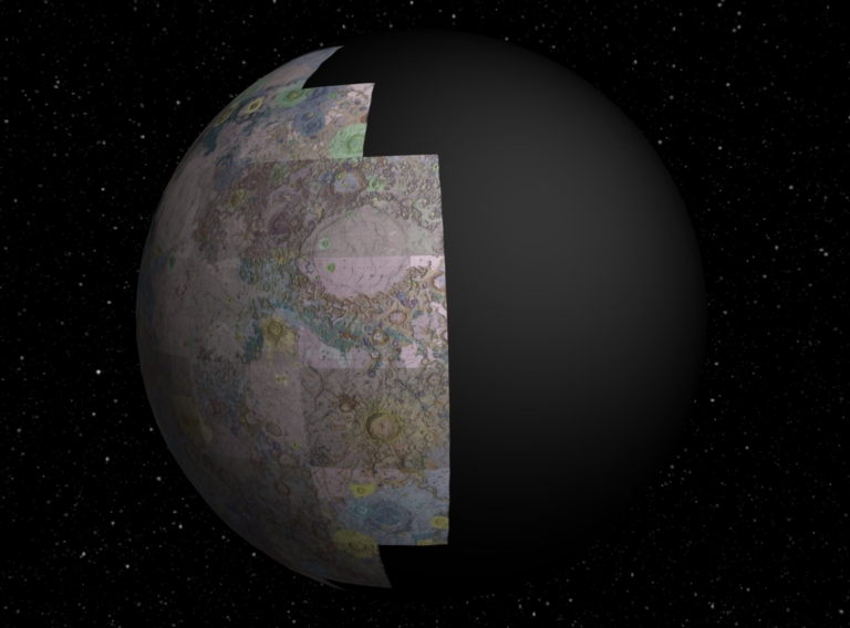
Full Title
(Interactive Globe) Sheets 1-44 of the Geologic Atlas of the Moon.
List No
12101.089
Author
[Hackman, R.J., U.S. Geological Survey]
Full Title
Geologic Map and Sections of the Kepler Region of the Moon. MAP I - 355 (LAC-57).
List No
12101.002
Author
[Marshall, C.H., U.S. Geological Survey]
Full Title
Geologic Map and Sections of the Letronne Region of the Moon. MAP I - 385 (LAC-75).
List No
12101.004
Author
U.S. Geological Survey
Full Title
Index Map of the Earthside Hemisphere of the Moon.
List No
12101.086
Note
Shows the relative positions of the 44 sheets that make up the Geologic Atlas of the Moon. Taken from the Macrobius sheet.
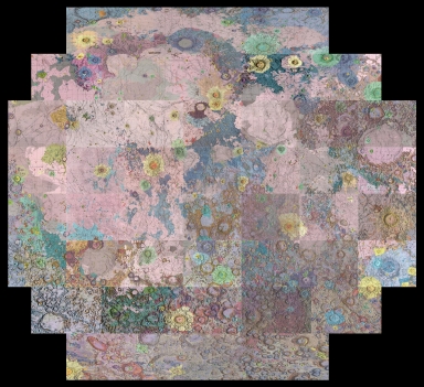
Author
U.S. Geological Survey
Full Title
(Composite map of) Sheets 1-44 of the Geologic Atlas of the Moon.
List No
12101.087
Note
Orthographic Projection.
Author
U.S. Geological Survey
Full Title
(Composite map of) Sheets 1-44 of the Geologic Atlas of the Moon.
List No
12101.088
Note
Geographic projection (unprojected)
Author
[Sayar, Ahmet Malik, Kenan, Damat]
Full Title
(Geological map of Anatolia). by Damat Kenan. Ahmet Malik . Contantinople, Matabb-i Amire, 1336 (1920).
List No
13288.000
Note
"Rare and Important – the first proper geological map of Turkey; a large, separately published work created by the professors Damat Kenan and Ahmet Malik Sayar, issued by the imperial printer in 1920 during the twilight of the Ottoman Empire, forming the foundation for scientific and commercial discovery during the upcoming Turkish Republican Era; printed in Ottoman Turkish text with resplendent original colours. This rare, large-format separately published work is the first comprehensive geological map of Turkey. Based upon the most recent and accurate field reconnaissance, it was compiled by the prominent academics Damat Kenan and Ahmet Malik Sayer, and was published by the Matbaa-ı Amire, the imperial state printer, in 1920, on the eve of the collapse of the Ottoman Empire. With text entirely in Ottoman Turkish script, and employing especially rich lithographed colours, the map embraces the western three-quarters of Anatolia (to a point just to the east of Trabzon); all of Cyprus; parts of Northern Syria and Lebanon, to a point south down just past Homs and Tripoli; as well as Eastern Thrace. The map brilliantly showcases the unusually complex geology of the region which lies along the Alpine-Himalayan tectonic belt, identifying 14 distinct geological zones, each coloured in their own resplendent hue. Additionally, symbols identify innumerable locations of mineral deposits, mines and quarries concerning 22 different minerals. Importantly, it notes the locations of major harbours, as well as delineating the region’s railroads (including the largely complete Baghdad Railway, which was to connect Constantinople with Baghdad), which were vital to bringing minerals to market. While geological maps of certain Turkish locales, as well as rough geological sketch maps of the greater region already existed, the present work provides the first comprehensive and accurate overview of the geology and mining industry in Anatolia and adjacent regions. It formed the foundation for the study of geology, as well as a key for resource development in Turkey over the coming years. Notably, the present map vitally assisted the production of the first statistical-mining atlas of Turkey, اطلاسي احصائياتي معدن [Maden Ihsaiyati Atlasi / Mining Atlas of Turkey] (Ankara, 1924), published for the ministry of trade; please see link: https://www.pahor.de/turkey-statistical-mining-atlas-maden-ihsaiyati-atlasi-mining-atlas-ofturkey-2887.html Historical Context: The Rise of Turkey out of the Ottoman Ashes While World War I (1914-8) prefigured the demise of the Ottoman Empire, it is a common Western misconception that Turkey simply ‘collapsed’ and resigned itself to defeat. On the contrary, while most Turks accepted that the Ottoman Empire, with its vast Arab-majority provinces, was not to survive, they were reenergised by the dream of creating a new nation focused upon Constantinople and Anatolia. While the victorious Entente Powers (mainly Britain, France and Italy, along with Greece) vowed to dismember Anatolia into zones of foreign occupation, many Turks had other ideas. Mustafa Kemal Pasha (1881 - 1938), later known as ‘Atatürk’, a former Ottoman army officer and hero of the Gallipoli Campaign, rallied Turkish nationalist forces during the Turkish War of Independence (1919-22). By 1922, he succeeded in both removing the foreign occupation of Anatolia, Constantinople and Eastern Thrace, while abolishing the Ottoman Empire. In 1923, he proclaimed the Republic of Turkey, serving as its folding president for the next 15 years, whereby he did much to modernize and strengthen the new nation. He is rightly remembered as one of the most visionary and successful World leaders of the 20th Century. The present map, while still made under the outgoing Ottoman regime, was created with the new ‘Kemalist’ can-do spirit in mind. Turkish intellectuals, such as Kenan and Sayar, knew that the new Turkish state that would arise out of the ashes of the Ottoman Empire, would need to exploit its significant natural resource wealth to build a modern industrial economy, to both keep the people employed and to support the military. The present map would have been vitally useful for strategic planning, to identify the locations of mines and quarries, as well as the means of transporting minerals to refineries and markets. Curiously, the present map omits the easternmost quarter of Anatolia. This is since the political fate of the region was then disputed, while it was difficult for geologists to survey the area. In 1920, the France and Britain still claimed zones of influence over the area, while promising to give much of it to an independent Armenian state. Moreover, the location of the Soviet boundary in the region was still in doubt. As it would turn out, Atatürk would settle the location of the Soviet-Turkish boundary with Lenin in 1921, while placing almost all Eastern Anatolia under Turkish rule, a reality internationally recognized by 1923. The authors of the map were the most respected authorities on mining and geology of their era. Damat Kenan, was a professor of mining at the Darülfünun (later known as the University of Istanbul). He co-authored the map with his younger colleague, Ahmet Malik Sayar (1892 - 1965), then a lecturer at the Darülfünun, as well as an instructor at the Halkalı School of Agriculture. The French-educated Sayar, who went on the publish numerous seminal academic studies, was subsequently recognized at the greatest Turkish geologist of the 20th Century. A Note on Rarity The present map is very rare; we cannot trace any institutional examples outside of Turkey. References: SALT Research Centre (Istanbul): APLAMK001; Şahap Nazmi Coşkunlar, Yeni yayınlar: Aylik bibliyografya dergisi, vols. 10-11 (1965), p. 385. Cf. On Professor Sayar: https://www.jmo.org.tr/resimler/ekler/827d1ec626c891d_ek.pdf " (Alex Johnson)
Author
[Staszic, Stanisław, 1755-1826, Hoffmann]
Full Title
(Composite Map)Carta Geologica totius Poloniae, Moldaviae, Transilvaniae et partis Hungariae et Valachiae. Inventa per Staszic, anno 1806. Hoffmann delin't. Frey sculp't.
List No
13273.005
Note
Composite map of sheets A-D.
Author
[Staszic, Stanisław, 1755-1826, Hoffmann]
Full Title
Carta Geologica totius Poloniae, Moldaviae, Transilvaniae et partis Hungariae et Valachiae. Inventa per Staszic, anno 1806. Hoffmann delin't. Frey sculp't.
List No
13273.006
Note
Sheet E: untitled hand colored geological profile of Poland and High Tatra Mountains.
Author
Delesse, Achille
Full Title
Carte geologique souterraine de la ville de Paris, publiee d’apres les ordres de M. le baron G. E. Haussmann, senateur, prefet de la Seine conformement a la deliberation du Conseil municipal du 8 novembre 1857 et executee par M. Delesse, ingenieur des mines, inspecteur des carrieres du departement de la Seine. 1858. Chromolith. Lernercier, Paris.
List No
11944.000
Note
Lithographed geological map of Paris on sheet 94x131, dissected into 18 sections, backed with linen folded to 33x23. drawn up by M. Delesse, at the request of the prefect of Seine Haussmann, was published under the auspices of the Department of the Inspectorate General of the Quarries of the City of Paris. Showing streets, footprint of major buildings, geological sections. Includes explanation, legend in color, and geological sections, drawn by Al. Babinski. Chromolithographed by Lernercier. Printed in Paris.
Author
[Willis, Bailey, Stose, George Willis, Geological Survey (U.S.)]
Full Title
(Composite map) Geologic map of North America. Compiled by the United States Geological Survey in cooperation with the Geological Survey of Canada and Instituto Geologico de Mexico ; under the supervision of Bailey Willis and George W. Stose. 1911. Geologic drafting by Henry S. Selden. Engraved and printed by the U.S. Geological Survey. (insets) Aleutian Islands. (with) Windward Islands. (at the margin) Professional paper 71. U.S. Geological Survey, George Otis Smith, Director.
List No
11746.005
Note
Composite map of sheets 1A-D: U.S.G.S. Professional paper 71.
Author
[Uren, Charles Edward, Bradley & Co.]
Full Title
Map of Bradley & Co's ditch property near Alta Station after the slide. E.C. Uren.
List No
11715.000
Note
Hand colored manuscript map of two heavy slides of earth that obstructed the tracks of the Central Pacific Railway near Alta California. From historical records it appears that the map may detail two slides that occurred along the railroad. The largest slide occurred in the Spring of 1866 during construction of the railroad and is shown in the center of the map with damages and repairs to the various ditches that ran through the area. The April 21, 1866 edition of the Dutch Flat Enquirer mentions "LAND SLIDE.—A huge land slide occurred a few days since near Buckley's ranch, just above this place, on the line of the C. P. Railroad, damaging the ditches of the Dutch Flat Water Company to the amount of several thousand dollars, and rendering a change of the railroad bed necessary, which will also cost an immense sum. Nearly a quarter section, extending along a heavy fill of the railroad several hundred yards, suddenly gave way and moved off in a solid body, taking with it ditches, flumes and everything else that obstructed its course, and making a change from the original survey of the railroad at that point imperative. The material that gave way, it seems, was of a soapy or pipe clay formation, and the pressure from the railroad fill is assigned as the cause." We estimate the map was drawn by Uren in 1880, looking back at that 1866 slide and also showing the recent 1880 slide that blocked the tracks in the upper left part of the map. The 1880 slide was recorded in the Scientific American issue Volume 42, noting that hydraulic mining techniques were used to blast away the debris covering the tracks. The map is unusual in showing illustrations of two Chinese Camps near the railroad line. With decorative compass rose, oriented with the north to upper left margin. Map showing railroad, steam engine, two views of Chinese camps, slide areas and views of Flume and water ditches. Date estimated. Uren writes his name on the map as E.C. Uren while we believe he is Charles Edward Uren.
Author
[Ministerstvo geologii, VSEGEI, Krasny, L. I., Fedynsky, V.V., Soviet Union. Ministerstvo geologii.]
Full Title
(Composite map) Karta seismichnosti tikhookeanskogo podvizhnogo poiasa i Tikhogo Okeana (1896-1968) = The map of the seismicity of the Pacific mobile belt and the Pacific Ocean. Editor in L.I. Krasny, V.V. Fedymsky ... 1973. Ministry of Geology of the USSR = Ministerstova Geologii SSSR. Moscva 1976.
List No
11601.010
Note
Composite of sheets 1-9, color map of the Pacific Ocean in 9 sheets, each 65x76. Map was made in 1973, this is 1976 edition in Russian and English. Showing the seismic activities measured between 1896 and 1968. The map shows the seismic activity and plate tectonics of the entire Pacific region, including North and South America and the islands of Southeast Asia. Includes legend, tables, notations and graphs. Relief shown by contours and spot height.
Author
Congres Geologique International, Commission de la Carte Geologique de Monde, Sous-Commission de la Carte Tectonique du Monde
Full Title
(Composite Map). Carte Tectonique Internationale de L'Europe.
List No
9053.017
Note
Author: Commission for the Geological Map of the World. Subcommission for the Tectonic Map of the World.
Author
[Kozlov, V.V., Nauchno-issledovatelʹskaia laboratoriia geologii zarubezhnykh stran]
Full Title
(Composite of) Tektonicheskaia karta luny : Tectonic map of the moon : Carte tectonique de la lune. (At head of title): Ministerstvo geologii SSSR. Nauchno issledovatelskaia laboratoriiia geologii zarubezhnykh stran. NILZarubezhgeologiia.
List No
11138.003
Note
Digital composite map of the Lunar geology,104x127 on 2 sheets, each 104x66. Title and text in Russian, English and French. Showing principal tectonic regions, structural patterns, regions of ocean tectogenesis, linear structural forms, etc. Includes: North polar region ; South polar region : 1:15,000,000 ; index to named locations ; Diagram of the main materials used. Zakaz 443-d.
Author
Guillemin-Tarayre, Edmond
Full Title
Carte Panoramique de la Region metallifere de Washoe (Etat de Nevada) par E. Guillemin-Tarayre. Cette carte est executee en projection gnomonique sur l'horizon du Mt. Davidson. Grave chex Erhard, Paris - Impr. Lemercier r. de Seine 57.
List No
11309.000
Note
Early map of Lake Tahoe and the Washoe Mining District on a Gnomonic Projection. One of the earliest geological and mining map of the region. Centered on Virginia City and extending to the Truckee River, Lake Tahoe, the Walker River and the Carson River. The outer ring of mountains locates Sevier Mountain, Pyramid Peak, Mt. Washoe, the Valley of the Carson River, and "Massif Palmyra." Towns named on the map include Washoe City, Fort Churchill, Genoa, Carson, with several dozen mines also named. Relief shown pictorially, by hachures and spot heights. Includes key to geological formation and notes. Guillemin-Tarayre's map is part of a rare set of scientific works published by the French government.
Author
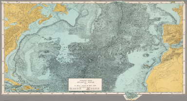
[Heezen, Bruce C., Tharp, Marie]
Full Title
Physiographic Diagram, Atlantic Ocean (Sheet 1).
List No
6368.000
Note
Date from WorldCat. Color.
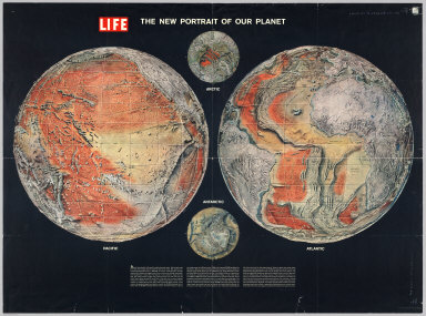
Author
Time Inc.
Full Title
The New Portrait of our Planet. Life.
List No
6369.000
Note
A Life magazine publication. Hemispheric projection.
Author
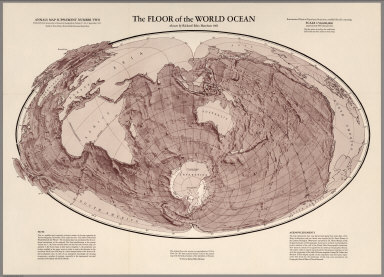
Harrison, Richard Edes
Full Title
The Floor of the World Ocean.
List No
6370.000
Note
Modified Briesmeister Elliptical Equal-Area Projection. Map Supplement Number Two, Annals of the Association of American Geographers, Volume 51, No.3, September 1961.
Author
[Kozlov, V.V., Nauchno-issledovatelʹskaia laboratoriia geologii zarubezhnykh stran]
Full Title
Tektonicheskaia karta luny : Tectonic map of the moon : Carte tectonique de la lune. (At head of title): Ministerstvo geologii SSSR. Nauchno issledovatelskaia laboratoriiia geologii zarubezhnykh stran. NILZarubezhgeologiia.
List No
11138.001
Note
One color map of the Lunar geology,104x127 on 2 sheets, each 104x66. Title and text in Russian, English and French. Showing principal tectonic regions, structural patterns, regions of ocean tectogenesis, linear structural forms, etc. Includes: North polar region ; South polar region : 1:15,000,000 ; index to named locations ; Diagram of the main materials used. Zakaz 443-d.
Author
[Kozlov, V.V., Nauchno-issledovatelʹskaia laboratoriia geologii zarubezhnykh stran]
Full Title
Tektonicheskaia karta luny : Tectonic map of the moon : Carte tectonique de la lune. (At head of title): Ministerstvo geologii SSSR. Nauchno issledovatelskaia laboratoriiia geologii zarubezhnykh stran. NILZarubezhgeologiia.
List No
11138.002
Note
One color map of the Lunar geology,104x127 on 2 sheets, each 104x66. Title and text in Russian, English and French. Showing principal tectonic regions, structural patterns, regions of ocean tectogenesis, linear structural forms, etc. Includes: North polar region ; South polar region : 1:15,000,000 ; index to named locations ; Diagram of the main materials used. Zakaz 443-d.
Author
National Iranian Oil Company
Full Title
National Iranian Oil Company : Geological map of Iran 1:2500000. Compiled by Geological staff of the Iran Oil Company. Based on the Iranian Oil Company's field work and photogeology and all other available information up to 1957. Copyright by National Iranian Oil Company. Orell Fussli Zurich.
List No
11182.000
Note
Color geological map of Iran. Relief shown by contours and spot heights. Includes geological symbols with explanatory notes. "Projection: Adjusted from polyconic projection of international 1:1,000,000 map of the earth."
Author
[Freytag & Berndt, Fritz, Max]
Full Title
Freytag & Berndt's Tektonische Schul Wandkarte der Erde. Druck und Verlag der kartogr. Anstalt G. Greytag & Berndt A.G., Wien. Bearbeitet von Prof. Dr. Max Fritz. (upper left sheet)
List No
11209.001
Note
Colored tectonic map of the World on 4 sheets 154x219, sheets 80x110. One of the earliest maps to illustrate the theory of Plate Tectonics, coming just 14 years after the theory was first proposed and 3 years before Arthur Holmes first proposed the thermal convection theory which would ultimately underpin the generally accepted theory of continental drift. shows the areas of volcanic and earthquake activity, geographical boundaries and major cities. Includes color coded reference. Depths shown by contours and gradient tints.
Author
[Freytag & Berndt, Fritz, Max]
Full Title
Freytag & Berndt's Tektonische Schul Wandkarte der Erde. Druck und Verlag der kartogr. Anstalt G. Greytag & Berndt A.G., Wien. Bearbeitet von Prof. Dr. Max Fritz. (upper right sheet)
List No
11209.002
Note
Colored tectonic map of the World on 4 sheets 154x219, sheets 80x110. One of the earliest maps to illustrate the theory of Plate Tectonics, coming just 14 years after the theory was first proposed and 3 years before Arthur Holmes first proposed the thermal convection theory which would ultimately underpin the generally accepted theory of continental drift. shows the areas of volcanic and earthquake activity, geographical boundaries and major cities. Includes color coded reference. Depths shown by contours and gradient tints.
Author
[Freytag & Berndt, Fritz, Max]
Full Title
Freytag & Berndt's Tektonische Schul Wandkarte der Erde. Druck und Verlag der kartogr. Anstalt G. Greytag & Berndt A.G., Wien. Bearbeitet von Prof. Dr. Max Fritz. (lower left sheet)
List No
11209.003
Note
Colored tectonic map of the World on 4 sheets 154x219, sheets 80x110. One of the earliest maps to illustrate the theory of Plate Tectonics, coming just 14 years after the theory was first proposed and 3 years before Arthur Holmes first proposed the thermal convection theory which would ultimately underpin the generally accepted theory of continental drift. shows the areas of volcanic and earthquake activity, geographical boundaries and major cities. Includes color coded reference. Depths shown by contours and gradient tints.
Author
[Freytag & Berndt, Fritz, Max]
Full Title
Freytag & Berndt's Tektonische Schul Wandkarte der Erde. Druck und Verlag der kartogr. Anstalt G. Greytag & Berndt A.G., Wien. Bearbeitet von Prof. Dr. Max Fritz. lower right sheet)
List No
11209.004
Note
Colored tectonic map of the World on 4 sheets 154x219, sheets 80x110. One of the earliest maps to illustrate the theory of Plate Tectonics, coming just 14 years after the theory was first proposed and 3 years before Arthur Holmes first proposed the thermal convection theory which would ultimately underpin the generally accepted theory of continental drift. shows the areas of volcanic and earthquake activity, geographical boundaries and major cities. Includes color coded reference. Depths shown by contours and gradient tints.
Author
[Freytag & Berndt, Fritz, Max]
Full Title
Freytag & Berndt's Tektonische Schul Wandkarte der Erde. Druck und Verlag der kartogr. Anstalt G. Greytag & Berndt A.G., Wien. Bearbeitet von Prof. Dr. Max Fritz.
List No
11209.005
Note
Colored tectonic map of the World on 4 sheets 154x219, sheets 80x110. One of the earliest maps to illustrate the theory of Plate Tectonics, coming just 14 years after the theory was first proposed and 3 years before Arthur Holmes first proposed the thermal convection theory which would ultimately underpin the generally accepted theory of continental drift. shows the areas of volcanic and earthquake activity, geographical boundaries and major cities. Includes color coded reference. Depths shown by contours and gradient tints.
Author
[Ministerstvo geologii, VSEGEI, Krasny, L. I., Fedynsky, V.V., Soviet Union. Ministerstvo geologii.]
Full Title
Karta seismichnosti tikhookeanskogo podvizhnogo poiasa i Tikhogo Okeana (1896-1968) = The map of the seismicity of the Pacific mobile belt and the Pacific Ocean. Editor in L.I. Krasny, V.V. Fedymsky ... 1973. Ministry of Geology of the USSR = Ministerstova Geologii SSSR. Moscva 1976.
List No
11601.001
Note
1 color map of the Pacific Ocean in 9 sheets, each 65x76. Map was made in 1973, this is 1976 edition in Russian and English. Showing the seismic activities measured between 1896 and 1968. The map shows the seismic activity and plate tectonics of the entire Pacific region, including North and South America and the islands of Southeast Asia. Includes legend, tables, notations and graphs. Relief shown by contours and spot height.
Author
[Ministerstvo geologii, VSEGEI, Krasny, L. I., Fedynsky, V.V., Soviet Union. Ministerstvo geologii.]
Full Title
Karta seismichnosti tikhookeanskogo podvizhnogo poiasa i Tikhogo Okeana (1896-1968) = The map of the seismicity of the Pacific mobile belt and the Pacific Ocean. Editor in L.I. Krasny, V.V. Fedymsky ... 1973. Ministry of Geology of the USSR = Ministerstova Geologii SSSR. Moscva 1976.
List No
11601.002
Note
1 color map of the Pacific Ocean in 9 sheets, each 65x76. Map was made in 1973, this is 1976 edition in Russian and English. Showing the seismic activities measured between 1896 and 1968. The map shows the seismic activity and plate tectonics of the entire Pacific region, including North and South America and the islands of Southeast Asia. Includes legend, tables, notations and graphs. Relief shown by contours and spot height.
Author
[Ministerstvo geologii, VSEGEI, Krasny, L. I., Fedynsky, V.V., Soviet Union. Ministerstvo geologii.]
Full Title
Karta seismichnosti tikhookeanskogo podvizhnogo poiasa i Tikhogo Okeana (1896-1968) = The map of the seismicity of the Pacific mobile belt and the Pacific Ocean. Editor in L.I. Krasny, V.V. Fedymsky ... 1973. Ministry of Geology of the USSR = Ministerstova Geologii SSSR. Moscva 1976.
List No
11601.003
Note
1 color map of the Pacific Ocean in 9 sheets, each 65x76. Map was made in 1973, this is 1976 edition in Russian and English. Showing the seismic activities measured between 1896 and 1968. The map shows the seismic activity and plate tectonics of the entire Pacific region, including North and South America and the islands of Southeast Asia. Includes legend, tables, notations and graphs. Relief shown by contours and spot height.
Author
[Ministerstvo geologii, VSEGEI, Krasny, L. I., Fedynsky, V.V., Soviet Union. Ministerstvo geologii.]
Full Title
Karta seismichnosti tikhookeanskogo podvizhnogo poiasa i Tikhogo Okeana (1896-1968) = The map of the seismicity of the Pacific mobile belt and the Pacific Ocean. Editor in L.I. Krasny, V.V. Fedymsky ... 1973. Ministry of Geology of the USSR = Ministerstova Geologii SSSR. Moscva 1976.
List No
11601.004
Note
1 color map of the Pacific Ocean in 9 sheets, each 65x76. Map was made in 1973, this is 1976 edition in Russian and English. Showing the seismic activities measured between 1896 and 1968. The map shows the seismic activity and plate tectonics of the entire Pacific region, including North and South America and the islands of Southeast Asia. Includes legend, tables, notations and graphs. Relief shown by contours and spot height.
Author
[Ministerstvo geologii, VSEGEI, Krasny, L. I., Fedynsky, V.V., Soviet Union. Ministerstvo geologii.]
Full Title
Karta seismichnosti tikhookeanskogo podvizhnogo poiasa i Tikhogo Okeana (1896-1968) = The map of the seismicity of the Pacific mobile belt and the Pacific Ocean. Editor in L.I. Krasny, V.V. Fedymsky ... 1973. Ministry of Geology of the USSR = Ministerstova Geologii SSSR. Moscva 1976.
List No
11601.005
Note
1 color map of the Pacific Ocean in 9 sheets, each 65x76. Map was made in 1973, this is 1976 edition in Russian and English. Showing the seismic activities measured between 1896 and 1968. The map shows the seismic activity and plate tectonics of the entire Pacific region, including North and South America and the islands of Southeast Asia. Includes legend, tables, notations and graphs. Relief shown by contours and spot height.
Author
[Ministerstvo geologii, VSEGEI, Krasny, L. I., Fedynsky, V.V., Soviet Union. Ministerstvo geologii.]
Full Title
Karta seismichnosti tikhookeanskogo podvizhnogo poiasa i Tikhogo Okeana (1896-1968) = The map of the seismicity of the Pacific mobile belt and the Pacific Ocean. Editor in L.I. Krasny, V.V. Fedymsky ... 1973. Ministry of Geology of the USSR = Ministerstova Geologii SSSR. Moscva 1976.
List No
11601.006
Note
1 color map of the Pacific Ocean in 9 sheets, each 65x76. Map was made in 1973, this is 1976 edition in Russian and English. Showing the seismic activities measured between 1896 and 1968. The map shows the seismic activity and plate tectonics of the entire Pacific region, including North and South America and the islands of Southeast Asia. Includes legend, tables, notations and graphs. Relief shown by contours and spot height.
Author
[Ministerstvo geologii, VSEGEI, Krasny, L. I., Fedynsky, V.V., Soviet Union. Ministerstvo geologii.]
Full Title
Karta seismichnosti tikhookeanskogo podvizhnogo poiasa i Tikhogo Okeana (1896-1968) = The map of the seismicity of the Pacific mobile belt and the Pacific Ocean. Editor in L.I. Krasny, V.V. Fedymsky ... 1973. Ministry of Geology of the USSR = Ministerstova Geologii SSSR. Moscva 1976.
List No
11601.007
Note
1 color map of the Pacific Ocean in 9 sheets, each 65x76. Map was made in 1973, this is 1976 edition in Russian and English. Showing the seismic activities measured between 1896 and 1968. The map shows the seismic activity and plate tectonics of the entire Pacific region, including North and South America and the islands of Southeast Asia. Includes legend, tables, notations and graphs. Relief shown by contours and spot height.
Author
[Ministerstvo geologii, VSEGEI, Krasny, L. I., Fedynsky, V.V., Soviet Union. Ministerstvo geologii.]
Full Title
Karta seismichnosti tikhookeanskogo podvizhnogo poiasa i Tikhogo Okeana (1896-1968) = The map of the seismicity of the Pacific mobile belt and the Pacific Ocean. Editor in L.I. Krasny, V.V. Fedymsky ... 1973. Ministry of Geology of the USSR = Ministerstova Geologii SSSR. Moscva 1976.
List No
11601.008
Note
1 color map of the Pacific Ocean in 9 sheets, each 65x76. Map was made in 1973, this is 1976 edition in Russian and English. Showing the seismic activities measured between 1896 and 1968. The map shows the seismic activity and plate tectonics of the entire Pacific region, including North and South America and the islands of Southeast Asia. Includes legend, tables, notations and graphs. Relief shown by contours and spot height.
Author
[Ministerstvo geologii, VSEGEI, Krasny, L. I., Fedynsky, V.V., Soviet Union. Ministerstvo geologii.]
Full Title
Karta seismichnosti tikhookeanskogo podvizhnogo poiasa i Tikhogo Okeana (1896-1968) = The map of the seismicity of the Pacific mobile belt and the Pacific Ocean. Editor in L.I. Krasny, V.V. Fedymsky ... 1973. Ministry of Geology of the USSR = Ministerstova Geologii SSSR. Moscva 1976.
List No
11601.009
Note
1 color map of the Pacific Ocean in 9 sheets, each 65x76. Map was made in 1973, this is 1976 edition in Russian and English. Showing the seismic activities measured between 1896 and 1968. The map shows the seismic activity and plate tectonics of the entire Pacific region, including North and South America and the islands of Southeast Asia. Includes legend, tables, notations and graphs. Relief shown by contours and spot height.
Author
[Willis, Bailey, Stose, George Willis, Geological Survey (U.S.)]
Full Title
Geologic map of North America. Compiled by the United States Geological Survey in cooperation with the Geological Survey of Canada and Instituto Geologico de Mexico ; under the supervision of Bailey Willis and George W. Stose. 1911. Geologic drafting by Henry S. Selden. Engraved and printed by the U.S. Geological Survey. (insets) Aleutian Islands. (with) Windward Islands. (at the margin) Professional paper 71. U.S. Geological Survey, George Otis Smith, Director.
List No
11746.001
Note
1 map on 4 sheers, 200x152, backed with linen. To accompany U.S. Geological Survey Professional paper 71, Plate 1A- D. Title from plate 1C. Includes legend of geological periods in color, keyed to map. Showing geological formations and place names.
Author
[Willis, Bailey, Stose, George Willis, Geological Survey (U.S.)]
Full Title
Geologic map of North America. Compiled by the United States Geological Survey in cooperation with the Geological Survey of Canada and Instituto Geologico de Mexico ; under the supervision of Bailey Willis and George W. Stose. 1911. Geologic drafting by Henry S. Selden. Engraved and printed by the U.S. Geological Survey. (insets) Aleutian Islands. (with) Windward Islands. (at the margin) Professional paper 71. U.S. Geological Survey, George Otis Smith, Director.
List No
11746.002
Note
1 map on 4 sheers, 200x152, backed with linen. To accompany U.S. Geological Survey Professional paper 71, Plate 1A- D. Title from plate 1C. Includes legend of geological periods in color, keyed to map. Showing geological formations and place names.
Author
[Willis, Bailey, Stose, George Willis, Geological Survey (U.S.)]
Full Title
Geologic map of North America. Compiled by the United States Geological Survey in cooperation with the Geological Survey of Canada and Instituto Geologico de Mexico ; under the supervision of Bailey Willis and George W. Stose. 1911. Geologic drafting by Henry S. Selden. Engraved and printed by the U.S. Geological Survey. (insets) Aleutian Islands. (with) Windward Islands. (at the margin) Professional paper 71. U.S. Geological Survey, George Otis Smith, Director.
List No
11746.003
Note
1 map on 4 sheers, 200x152, backed with linen. To accompany U.S. Geological Survey Professional paper 71, Plate 1A- D. Title from plate 1C. Includes legend of geological periods in color, keyed to map. Showing geological formations and place names.
Author
[Willis, Bailey, Stose, George Willis, Geological Survey (U.S.)]
Full Title
Geologic map of North America. Compiled by the United States Geological Survey in cooperation with the Geological Survey of Canada and Instituto Geologico de Mexico ; under the supervision of Bailey Willis and George W. Stose. 1911. Geologic drafting by Henry S. Selden. Engraved and printed by the U.S. Geological Survey. (insets) Aleutian Islands. (with) Windward Islands. (at the margin) Professional paper 71. U.S. Geological Survey, George Otis Smith, Director.
List No
11746.004
Note
1 map on 4 sheers, 200x152, backed with linen. To accompany U.S. Geological Survey Professional paper 71, Plate 1A- D. Title from plate 1C. Includes legend of geological periods in color, keyed to map. Showing geological formations and place names.
Author
Oppenheim, Victor
Full Title
Mapa Geologico do Brasil Meridional, Sedimentos e Derrames de Balsaltos Gondwanicos (southern sheet).
List No
12012.001
Author
Oppenheim, Victor
Full Title
Mapa Geologico do Brasil Meridional, Sedimentos e Derrames de Balsaltos Gondwanicos (northern sheet).
List No
12012.002
Author
Oppenheim, Victor
Full Title
(Composite Map) Mapa Geologico do Brasil Meridional, Sedimentos e Derrames de Balsaltos Gondwanicos.
List No
12012.003
Author
Oppenheim, Victor
Full Title
First Generalized Geologic Compilation Map of Colombia.
List No
12013.000
Author
Beudant, Francois-Sulpice 1787-1850
Full Title
Carte Geologique de la Hongrie et de la Transylvanie avec une partie des pays limitrophes,
List No
12071.000
Author
[Eggleton, R.E., U.S. Geological Survey]
Full Title
Geologic Map of the Riphaeus Mountains Region of the Moon. MAP I - 458 (LAC-76).
List No
12101.006
Author
[Carr, M.H., U.S. Geological Survey]
Full Title
Geologic Map and Section of the Timocharis of the Moon. MAP I - 462 (LAC-40).
List No
12101.008
Author
[Hackman, R.J., U.S. Geological Survey]
Full Title
Geologic Map of the Montes Apenninus Region of the Moon. MAP I - 463 (LAC-41).
List No
12101.010
Author
[Moore, H.J., U.S. Geological Survey]
Full Title
Geologic Map of the Aristarchus Region of the Moon. MAP I - 465 (LAC-39).
List No
12101.012
Author
[Trask, N.J.; Titley, S.R., U.S. Geological Survey]
Full Title
Geologic Map of Pitatus Region of the Moon. MAP I - 485 (LAC-94).
List No
12101.014
Author
[Carr, M.H., U.S. Geological Survey]
Full Title
Geologic Map of the Mare Serenitatus Region of the Moon. MAP I - 489 (LAC-42).
List No
12101.016
Author
[McCauley, John F., U.S. Geological Survey]
Full Title
Geologic Map of the Hevelius Region of the Moon. MAP I - 491 (LAC-56).
List No
12101.018
Author
[Titley, S.R., U.S. Geological Survey]
Full Title
Geologic Map of the Mare Humorum Region of the Moon. MAP I - 495 (LAC 93).
List No
12101.020
Author
[Morris, Elliot C., U.S. Geological Survey, Wilhelms, Don E.]
Full Title
Geologic Map of Julius Caesar Quadrangle of the Moon. MAP I - 510 (LAC-60).
List No
12101.022
Author
[Schmitt, H.H., U.S. Geological Survey, Trask, N.J., Shoemaker, E.M.]
Full Title
Geologic Map of the Copernicus Quadrangle of the Moon. MAP I - 515 (LAC-58).
List No
12101.024
Author
[Moore, H.J., U.S. Geological Survey]
Full Title
Geologic Map of the Seleucus Quadrangle of the Moon. MAP I - 527 (LAC-38).
List No
12101.026
Author
[Milton, Daniel J., U.S. Geological Survey]
Full Title
Geologic Map of the Theopilus Quadrangle of the Moon. MAP I - 546 (LAC-78).
List No
12101.028
Author
[Wilhelms, Don E., U.S. Geological Survey]
Full Title
Geologic Map of the Mare Vaporum Quadrangle of the Moon. MAP I - 548 (LAC 59).
List No
12101.030
Author
[Howard, Keith A., U.S. Geological Survey, Masursky, Harold]
Full Title
Geologic Map of the Ptolemaeus Quadrangle of the Moon. MAP I - 566 (LAC-77; RLC-13).
List No
12101.032
Author
[McCauley, John F., U.S. Geological Survey]
Full Title
Geologic Map of the Alphonsus GA of the Moon. MAP I - 586 (RLC 15).
List No
12101.034
Author
[Carr, Michael H., U.S. Geological Survey]
Full Title
Geologic Map of the Alphonsus Region of the Moon. MAP I - 599 (RLC-14).
List No
12101.036
Author
[Schaber, Gerald G., U.S. Geological Survey]
Full Title
Geologic Map of the Sinus Iridum Quadrangle of the Moon. MAP I - 602 (LAC 24).
List No
12101.038
Author
[Ulrich, G.E., U.S. Geological Survey]
Full Title
Geologic Map of the J. Herschel Quadrangle of the Moon. MAP I - 604 (LAC-11).
List No
12101.040
Author
[Page, N.J., U.S. Geological Survey]
Full Title
Geologic Map of the Cassini Quadrangle of the Moon. MAP I - 666 (LAC-25)
List No
12101.042
Author
[Rowan, L.C., U.S. Geological Survey]
Full Title
Geologic Map of the Rupes Altai Quadrangle of the Moon. MAP I - 690 (LAC 96).
List No
12101.044
Author
[Offield, Terry W., U.S. Geological Survey]
Full Title
Geologic Map of the Schiller Quadrangle of the Moon. MAP I - 691 (LAC 125).
List No
12101.046
Author
[Stuart-Alexander, Desiree E., U.S. Geological Survey]
Full Title
Geologic Map of the Rheita Quadrangle of the Moon. MAP I - 694 (LAC-114).
List No
12101.048
Author
[Scott, David H., U.S. Geological Survey]
Full Title
Geologic Map of the Maurolycus Quadrangle of the Moon. MAP I - 695 (LAC 113).
List No
12101.050
Author
[M'Gonigle, John W., U.S. Geological Survey, Schleicher, David]
Full Title
Geologic Map of the Plato Quadrangle of the Moon. MAP I - 701 (LAC-12).
List No
12101.052
Author
[Mutch, Thomas A., U.S. Geological Survey, Sunders, R. Stephen]
Full Title
Geologic Map of the Hommel Quadrangle of the Moon. MAP I - 702 (LAC 127).
List No
12101.054
Author
[Scott, David H., U.S. Geological Survey]
Full Title
Geologic Map of the Eudoxus Quadrangle of the Moon. MAP I - 705 (LAC-26).
List No
12101.056
Author
[Cummings, David, U.S. Geological Survey]
Full Title
Geologic Map of the Clavius Quadrangle of the Moon. MAP I - 706 (LAC-126).
List No
12101.058
Author
[Casella, Clarence J., U.S. Geological Survey, Binder, Alan B.]
Full Title
Geologic Map of the Cleomedes Quadrangle of the Moon. MAP I - 707 (LC 44).
List No
12101.060
Author
[Pohn, H.A., U.S. Geological Survey]
Full Title
Geologic Map of the Tycho Quadrangle of the Moon. MAP I - 713 (LAC 112).
List No
12101.062
Author
[Elston, Donald P., U.S. Geological Survey]
Full Title
Geologic Map of the Colombo Quadrangle of the Moon. MAP I - 714 (LAC-79).
List No
12101.064
Author
[Stuart-Alexander, Desiree E., U.S. Geological Survey, Tabor, Rowland W.]
Full Title
Geologic Map of the Fracastorius Quadrangle of the Moon. MAP I - 720 (LAC-97).
List No
12101.066
Author
[Wilhelms, Don E., U.S. Geological Survey]
Full Title
Geologic Map of the Taruntius Quadrangle of the Moon. MAP I - 722 (LAC-61).
List No
12101.068
Author
[Lucchitta, Baerbel Koesters, U.S. Geological Survey]
Full Title
Geologic Map of the Aristoteles Quadrangle of the Moon. MAP I - 725 (LAC-13).
List No
12101.070
Author
[Hodges, Carroll Ann, U.S. Geological Survey]
Full Title
Geologic Map of the Langrenus Quadrangle of the Moon. MAP I - 739 (LAC-80).
List No
12101.072
Author
[Scott, D.H., U.S. Geological Survey, Pohn, H.A.]
Full Title
Geologic Map of the Macrobius Quadrangle of the Moon. MAP I - 799 (LAC-43).
List No
12101.074
Author
[Pike, Richard J., U.S. Geological Survey]
Full Title
Geologic Map of the Rima Hyginus Region of the Moon. MAP I - 945.
List No
12101.076
Author
[Holt, H. E., U.S. Geological Survey]
Full Title
Geologic Map of the Purbach Quadrangle of the Moon.
List No
12101.077
Note
Image is courtesy of the online Geologic Atlas of the Moon maintained by the Lunar and Planetary Institute
Author
[Scott, D.H., U.S. Geological Survey, Eggleton, R.E.]
Full Title
Geologic Map of the Rumker Quadrangle of the Moon.
List No
12101.078
Note
Image is courtesy of the online Geologic Atlas of the Moon maintained by the Lunar and Planetary Institute
Author
[Grolier, Maurice J., U.S. Geological Survey]
Full Title
Geologic Map of the Geminus Quadrangle of the Moon.
List No
12101.079
Note
Image is courtesy of the online Geologic Atlas of the Moon maintained by the Lunar and Planetary Institute
Author
[Olson, Annable B., U.S. Geological Survey, Williams, Don E.]
Full Title
Geologic Map of the Undarem Quadrangle of the Moon.
List No
12101.080
Note
Image is courtesy of the online Geologic Atlas of the Moon maintained by the Lunar and Planetary Institute
Author
[McCauley, John F., U.S. Geological Survey]
Full Title
Geologic Map of the Grimaldi Quadrangle of the Moon.
List No
12101.081
Note
Image is courtesy of the online Geologic Atlas of the Moon maintained by the Lunar and Planetary Institute
Author
[Wilshire, H. G., U.S. Geological Survey]
Full Title
Geologic Map of the Byrgius Quadrangle of the Moon.
List No
12101.082
Note
Image is courtesy of the online Geologic Atlas of the Moon maintained by the Lunar and Planetary Institute
Author
[Hodges, Carroll Ann, U.S. Geological Survey]
Full Title
Geologic Map of the Petavius Quadrangle of the Moon.
List No
12101.083
Note
Image is courtesy of the online Geologic Atlas of the Moon maintained by the Lunar and Planetary Institute
Author
[Saunders, R. S., U.S. Geological Survey, Wilhelms, Don E.]
Full Title
Geologic Map of the Wilhelm Quadrangle of the Moon.
List No
12101.084
Note
Image is courtesy of the online Geologic Atlas of the Moon maintained by the Lunar and Planetary Institute
Author
[Karlstrom, N.V., U.S. Geological Survey]
Full Title
Geologic Map of the Schickard Quadrangle of the Moon.
List No
12101.085
Note
Image is courtesy of the online Geologic Atlas of the Moon maintained by the Lunar and Planetary Institute
Author
[Hackman, Robert J., U.S. Geological Survey]
Full Title
Engineer Special Study of the Surface of the Moon. Generalized Photogeologic Map of the Moon. Miscellaneous Geologic Investigations (1 of 4).
List No
12102.002
Note
Colored.
Author
[Hackman, Robert J., U.S. Geological Survey]
Full Title
Engineer Special Study of the Surface of the Moon. Lunar Rays. Miscellaneous Geologic Investigations (2 of 4).
List No
12102.003
Author
[Hackman, Robert J., U.S. Geological Survey, Mason, Arnold C.]
Full Title
Engineer Special Study of the Surface of the Moon. Physiographic Divisions of the Moon. Miscellaneous Geologic Investigations (3 of 4).
List No
12102.004
Author
Featherstonhaugh, George William
Full Title
A map of a portion of the Indian country lying east and west of the Mississippi River to the forty sixth degree of north latitude from personal observation made in the autumn of 1835 and recent authentic documents. Constructed for the Topographical Bureau by G.W.F., U.S. Geolt.
List No
13044.000
Note
Land grants map. Shows lands ceded by Indians tribes, lands inhabitation by Indians by tribe, land grants, Indian reservations, land districts, portage points, boundary claims, towns and Indian villages, rivers and lakes.
Author
[Staszic, Stanisław, 1755-1826, Hoffmann]
Full Title
Carta Geologica totius Poloniae, Moldaviae, Transilvaniae et partis Hungariae et Valachiae. Inventa per Staszic, anno 1806. Hoffmann delin't. Frey sculp't.
List No
13273.001
Note
Hand colored map Sheet A. Includes decorative title casrtouche and legend.
Author
[Staszic, Stanisław, 1755-1826, Hoffmann]
Full Title
Carta Geologica totius Poloniae, Moldaviae, Transilvaniae et partis Hungariae et Valachiae. Inventa per Staszic, anno 1806. Hoffmann delin't. Frey sculp't.
List No
13273.002
Note
Hand colored map Sheet B.
Author
[Staszic, Stanisław, 1755-1826, Hoffmann]
Full Title
Carta Geologica totius Poloniae, Moldaviae, Transilvaniae et partis Hungariae et Valachiae. Inventa per Staszic, anno 1806. Hoffmann delin't. Frey sculp't.
List No
13273.003
Note
Hand colored map Sheet C.
Author
[Staszic, Stanisław, 1755-1826, Hoffmann]
Full Title
Carta Geologica totius Poloniae, Moldaviae, Transilvaniae et partis Hungariae et Valachiae. Inventa per Staszic, anno 1806. Hoffmann delin't. Frey sculp't.
List No
13273.004
Note
Hand colored map Sheet D.
Author
Rogers, Henry Darwin
Full Title
A Geological Map of New Jersey, by Henry D. Rogers, Prof. of Geology in Univ. of Penna. (To accompany the Report on the Geology of N. Jersey,) Jan. 1839. P.S. Duval, Lith. Philada. On Stone by J. Probst.
List No
3346.000
Note
Marcou lists this as the first Geological map of New Jersey. Accompanies Rogers' "Description of the geology of the State of New Jersey, being a final report," Philadelphia, 1840. Report not present here. Rodgers used the Gordon/Tanner map as a base. Full color by geological formation. Relief shown by hachures.
Author
[Franks, Theo., Brady's Bend Iron Co.]
Full Title
Topographical & Geological Map Of The Property Belonging To The Brady's Bend Iron Co. Located In Armstrong County Pa. by Theo. Franks Civil Engineer. From Plan drawn by R. Jennings, Brady's Bend. Wm Schuchman, lith. 3d St, Pittsburgh, Pa. (inset) Geological Section From Notes By Prof. Shepherd.
List No
5002.000
Note
This remarkable large map shows in great detail the works of the Brandy's Bend Iron Co. on the Allegheny River northeast of Pittsburgh. The scale is large and the map is subtly colored. All the buildings, tracks, roads and Collieries are delineated. There is a "Geological Section from Notes by Prof. Shepherd" showing the land on which the Iron Company is built. Two vignettes show the imposing buildings. Why this map was made is not clear, certainly not for general consumption, but perhaps for investors or others specifically interested in the Companies facilities. The date is estimated. Scale 300 feet to an inch.
Author
[Whitney, J.D., Foster, J.W.]
Full Title
Carte geologique du Lac Superieur. Etat De Michigan. Drefsee par M.rs J.W. Fosters et J.D. Whitney geologues des Etats Unia. Annales des Mines, 5e Serie, Tome VII, pages 173 et suivantes. Lemaitre sc. Voyage au Lac Superieur. Geologie. Pl. VI.
List No
5290.000
Note
This is a French issue of the Foster/Whitney geological maps of Lake Superior from the 1849 report (see our #1059). Hand-painted color shows geologic formation in the Lake Superior vicinity.
Author
[Hayden, F.V., U.S. Geological and Geographical Survey of the Territories]
Full Title
Part of Central Wyoming, U.S. Geological and Geographical Survey of the Territories ; F.V. Hayden, U.S. Geologist in Charge. F.M. Endlich , Geological Assistant. George B. Chittenden, C. F. Topographical Assistant. Surveyed in 1877.
List No
5942.000
Note
Full color geologic map. Shows geologic formations and sedimentary chart. Relief by shown by contours and spot heights. " Contour interval 200 feet". "57" on the Lower right margin. To accompany the Survey's 12th annual report (1878).
Author
[U.S. Geological and Geographical Survey of the Territories, Hayden,Ferdinand Vandeveer]
Full Title
Parts of Western Wyoming and Southeastern Idaho. U.S. Geological and Geographical Survey of the Territories ; F.V. Hayden, U.S. Geologist in Charge. O. St. John, Geological Assistant. Gustavus R Bechler; Fred A Clark; Topographical Assistants. Surveyed in 1877 & 78.
List No
5944.000
Note
Full color geologic map. Shows geologic formations and sedimentary chart. Relief by shown by contours and spot heights. " Contour interval 200 feet". "45" on the Lower right margin. To accompany the Survey's 12th annual report (1878).
Author
[U.S. Geological and Geographical Survey of the Territories, Hayden,Ferdinand Vandeveer]
Full Title
Preliminary Geological Map of the Yellowstone National Park. Department of the Interior, U.S. Geological and Geographical Survey of the Territories ; F.V. Hayden, U.S. Geologist in Charge ; W.H. Holmes, Geological Assistant ; Primary Triangulation by A.D. Wilson ; Secondary Triangulation and Topography by Henry Gannett. Surveyed in 1878. Julius Bien, Lith.
List No
5947.000
Note
Full color map. Relief shown by contours and spot heights. Depths shown by soundings. Includes sedimentary charts, and notes. No. 6 on verso. To accompany the Survey's 12th annual report (1878).
Author
[U.S. Geological and Geographical Survey of the Territories, Hayden,Ferdinand Vandeveer]
Full Title
Geological Map of Portions of Wyoming, Idaho and Utah. Department of the Interior, U.S. Geological and Geographical Survey of the Territories ; F.V. Hayden, U.S. Geologist in Charge ; Geology by A C Peale; Orestes St John; F.M. Endlich. Julius Bien, Lith., N.Y.
List No
5948.000
Note
Full color map. Relief shown by hachures and spot heights. Includes sedimentary charts. To accompany the Survey's 12th annual report (1878).
Author
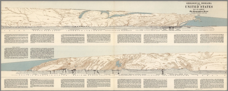
Lobeck, A. K.
Full Title
Geological Diorama of the United States. By A.K. Lobeck, The Geographical Press, Columbia University, New York, 1949.
List No
6095.000
Author
Loader, T. B.
Full Title
Under the patronage of His Majesty, T.B. Loader's scientific and commercial map of England and Wales in which are delineated the canals, rail-roads, & navigable rivers : the extent of the navigation of each river, with the elevations of the canals, together with the geology, and principal situations of the mineral productions. 1834. Published by T.B. Loader, 31 Bedford, St. Covent Garden. Mounted & colored by G. Cross, 98 Dean St. Soho.
List No
6887.000
Note
Color map, dissected and mounted on cloth ; 128 x 103, folded to 23 x 14. Shows rivers, canals, railroads, lighthouses, and roads. Includes geological references and ores, and explanation.
Author
[Allan Cartography, Dynamic Graphics, Inc.]
Full Title
Tectonic California. Dynamic Graphics, Inc. ... Berkeley, California 94705 ....
List No
7869.000
Note
Shows California and Nevada and marine topography and the San Andreas Fault now and 5 million years in the past and future.
Author
Raisz, Erwin
Full Title
The World in Armadillo.
List No
7943.001
Note
Date estimated.
Author
Raisz, Erwin
Full Title
(World). Relief drawing.
List No
7943.002
Note
Denoyer Semi-elliptical projection. Publisher: Chicago: Denoyer-Geppert Co.
Author
Raisz, Erwin
Full Title
The Pattern of World Agriculture.
List No
7943.003
Note
Basemap by Vernor C. Finch. Prepared at the Inst. of Geographical Exploration, Harvard University, for the Yearbook of Agriculture (U.S. Department of Agriculture), 1941. After D.S. Whittlesey by Erwin Raisz, 2nd ed. 1955.
Author
Raisz, Erwin
Full Title
Landform Map of Canada prepared for the Environmental Protection Section of the Office of the U.S. Quartermaster General by Erwin Raisz in 1950. Hydrography by Robert L. Williams. (inset) Canada in the Northern Hemisphere.
List No
7943.004
Note
Lambert Conformal Conic Projection. Prepared at the Institute of Geographical Exploration, Harvard University, Cambridge, Mass. in 1949.
Author
Raisz, Erwin
Full Title
Landform Map of Canada prepared for the Environmental Protection Section of the Office of the U.S. Quartermaster General by Erwin Raisz in 1950. Hydrography by Robert L. Williams. (inset) Canada in the Northern Hemisphere.
List No
7943.005
Note
Lambert Conformal Conic Projection. Prepared at the Institute of Geographical Exploration, Harvard University, Cambridge, Mass. in 1949.
Author
Raisz, Erwin
Full Title
Landforms of the United States by Erwin Raisz to Accompany Atwood's "Physiographic Provinces of North America". (inset) Physiographic Provinces.
List No
7943.006
Note
6th revised edition.
Author
Raisz, Erwin
Full Title
Landforms of the United States by Erwin Raisz to Accompany Atwood's "Physiographic Provinces of North America". (inset) Physiographic Provinces.
List No
7943.007
Note
6th revised edition. Lacks the box showing physiographic symbols.
Author
Raisz, Erwin
Full Title
Landforms of the Northwestern States. Prepared at the Institute of Geographical Exploration, Harvard University, Cambridge, Mass. by Erwin Raisz 1941.
List No
7943.008
Author
Raisz, Erwin
Full Title
Landforms of the Northwestern States. Prepared at the Institute of Geographical Exploration, Harvard University by Erwin Raisz 1941.
List No
7943.009
Note
3rd revised edition.
Author
Raisz, Erwin
Full Title
Landform Map of Alaska by Erwin Raisz. Originally prepared for the Environmental Protection Section, Office of the Quartermaster General. Hydrography by Robert L. Williams. (inset) Location of Alaska in the Northern Hemisphere.
List No
7943.010
Note
2nd revised edition.
Author
Raisz, Erwin
Full Title
Landforms of California and Nevada from W.W. Atwood: Physiographic Provinces of North America. Ginn & Co. Boston, Mass. by Erwin Raisz. (inset) Major Landforms Regions.
List No
7943.011
Note
Revised edition 1965.
Author
Raisz, Erwin
Full Title
Landforms of California and Nevada from W.W. Atwood: Physiographic Provinces of North America. Ginn & Co. Boston, Mass. by Erwin Raisz. (inset) Major Landforms Regions.
List No
7943.012
Note
Revised edition 1961.
Author
Raisz, Erwin
Full Title
Land and Water of the United States.
List No
7943.013
Note
Date estimated. Color. Major drainages.
Author
Raisz, Erwin
Full Title
Landform outline map of the United States with adjacent parts of Canada and Mexico by Erwin Raisz without lettering.
List No
7943.014
Author
Raisz, Erwin
Full Title
Landforms of Central America.
List No
7943.015
Author
Raisz, Erwin
Full Title
Central America Land Forms by Erwin Raisz. Census Atlas Maps of Latin America Map 1. Part 1A. Census Atlas Project, U.S. Bureau of the Census, Department of Commerce, in Cooperation withthe Foreign Operations Administration. OCIS 6-55.1.
List No
7943.016
Author
Raisz, Erwin
Full Title
Greater Antilles.
List No
7943.017
Author
Raisz, Erwin
Full Title
Landforms of Mexico. Prepared for the Geography Branch of the Office of Naval Research by Erwin Raisz. (insets) Physiographic Provinces. States and Territories.
List No
7943.018
Note
2nd corrected edition 1964.
Author
Raisz, Erwin
Full Title
Venezuela Landforms, E. Raisz.
List No
7943.019
Author
Raisz, Erwin
Full Title
Landform Map of North Africa by Erwin Raisz. Basemap Prepared for Environmental Protection Branch, Office of the Quartermaster General. (inset) Political Divisions, Landform Regions.
List No
7943.020
Author
Raisz, Erwin
Full Title
Italy.
List No
7943.021
Author
Raisz, Erwin
Full Title
Landforms of Europe by Edwin Raisz. (insets) Physiographic Provinces. Europe during the Ice Ages.
List No
7943.022
Author
Raisz, Erwin
Full Title
Landform Map of England. Prepared by Erwin Raisz, 107 Washington Ave., Cambridge, Mass. 02140.
List No
7943.023
Note
2nd revised edition. Original 1948.
Author
Raisz, Erwin
Full Title
Landforms of Asia by Erwin Raisz. (inset) (Political Map of Asia).
List No
7943.024
Author
Raisz, Erwin
Full Title
Japan.
List No
7943.025
Author
Raisz, Erwin
Full Title
Landforms of China by Erwin Raisz 1955 from G.B. Cressey: Land of the 500 Million, McGraw-Hill Book Co, 1955.
List No
7943.026
Author
Raisz, Erwin
Full Title
Landforms of the Near East. Base Map Prepared for Environmental Protection Section, Office of the Quartermaster General. By Erwin Raisz 1951. Prepared at the Institute of Geographical Exploration of Harvard University in Cambridge Mass. (insets) Reliability. (Coverage). Political Divisions. Landform Regions.
List No
7943.027
Author
Raisz, Erwin
Full Title
Landforms of the Arabia. Prepared for Environmental Protection Section, Office of the Quartermaster General by Erwin Raisz. Prepared at the Institute of Geographical Exploration of Harvard University in Cambridge Mass. (insets) Reliability. (Political Divisions. Landform Regions.
List No
7943.028
Note
Date estimated.
Author
Raisz, Erwin
Full Title
Landforms of the United States by Erwin Raisz to Accompany Atwood's "Physiographic Provinces of North America". (inset) Physiographic Provinces.
List No
7943.031
Note
6th revised edition.
Author
Raisz, Erwin
Full Title
Landforms of China by Erwin Raisz 1955 from G.B. Cressey: Land of the 500 Million, McGraw-Hill Book Co, 1955.
List No
7943.032
Author
Raisz, Erwin
Full Title
Landforms of Europe by Edwin Raisz. (insets) Physiographic Provinces. Europe during the Ice Ages.
List No
7943.033
Author
Raisz, Erwin
Full Title
Africa. By permission of the McGraw-Hill Encyclopedia of Science and Technology.
List No
7943.034
Note
Date estimated.
Author
[Raisz, Erwin, Mills, Christopher]
Full Title
Landforms of Michigan by Erwin Raisz and Christopher Mills. (insets) Regions. Successive Ice Fronts & Moraines.
List No
7943.035
Author
[Raisz, Erwin, Mills, Christopher]
Full Title
Landforms of Utah by Erwin Raisz.
List No
7943.036
Note
Includes cross section.
Author
[Raisz, Erwin, Mills, Christopher]
Full Title
Physiographic Map of Tennessee. Map from "The Geography of Tennessee" published by Ginn and Co.
List No
7943.037
Note
Date estimated. Includes cross section.
Author
I. Pekoy & Sia.
Full Title
Pagkosmios Geofysicos Chartes. Ekdoseis Pekoy. (on verso) Pagkosmios Politikos Chartes. (Cover title) Pagkosmios Chartes : Politikos - Geofysicos , Paragogikos. Ekdoseis: I. Pekoy & Sia. 02/01/01.
List No
8312.003
Note
Two maps, full color on one sheet, 70x98, both sides, folded into pictorial paper covers 25x17.5, with title: Pagkosmios Chartes : Politikos - Geofysicos, Paragogikos, with imprint on verso. Political geophysical and production map of the world. Published by I. Pekoy and Company. Include international time zones on lower borders. Political map includes flag of the countries on lower and left margins, shows political divisions, capitals, state boundaries on some countries, major cities, roads, rivers, productions, etc. Relief and depth shown by gradient tints.
Author
Congres Geologique International, Commission de la Carte Geologique de Monde, Sous-Commission de la Carte Tectonique du Monde
Full Title
(Covers and Title Page to) Feuille 1. Carte Tectonique Internationale de L'Europe. Congres Geologique International, Commission de la Carte Geologique de Monde, Sous-Commission de la Carte Tectonique du Monde. 1:2,500,000. 1962.
List No
9053.001
Note
Author: Commission for the Geological Map of the World. Subcommission for the Tectonic Map of the World.
Author
Congres Geologique International, Commission de la Carte Geologique de Monde, Sous-Commission de la Carte Tectonique du Monde
Full Title
Feuille 2. Carte Tectonique Internationale de L'Europe.
List No
9053.002
Note
Author: Commission for the Geological Map of the World. Subcommission for the Tectonic Map of the World.
Author
Congres Geologique International, Commission de la Carte Geologique de Monde, Sous-Commission de la Carte Tectonique du Monde
Full Title
Feuille 3. Carte Tectonique Internationale de L'Europe.
List No
9053.003
Note
Author: Commission for the Geological Map of the World. Subcommission for the Tectonic Map of the World.
Author
Congres Geologique International, Commission de la Carte Geologique de Monde, Sous-Commission de la Carte Tectonique du Monde
Full Title
Feuille 4. Carte Tectonique Internationale de L'Europe.
List No
9053.004
Note
Author: Commission for the Geological Map of the World. Subcommission for the Tectonic Map of the World.
Author
Congres Geologique International, Commission de la Carte Geologique de Monde, Sous-Commission de la Carte Tectonique du Monde
Full Title
Feuille 5. Carte Tectonique Internationale de L'Europe.
List No
9053.005
Note
Author: Commission for the Geological Map of the World. Subcommission for the Tectonic Map of the World.
Author
Congres Geologique International, Commission de la Carte Geologique de Monde, Sous-Commission de la Carte Tectonique du Monde
Full Title
Feuille 6. Carte Tectonique Internationale de L'Europe.
List No
9053.006
Note
Author: Commission for the Geological Map of the World. Subcommission for the Tectonic Map of the World.
Author
Congres Geologique International, Commission de la Carte Geologique de Monde, Sous-Commission de la Carte Tectonique du Monde
Full Title
Feuille 7. Carte Tectonique Internationale de L'Europe.
List No
9053.007
Note
Author: Commission for the Geological Map of the World. Subcommission for the Tectonic Map of the World.
Author
Congres Geologique International, Commission de la Carte Geologique de Monde, Sous-Commission de la Carte Tectonique du Monde
Full Title
Feuille 8. Carte Tectonique Internationale de L'Europe.
List No
9053.008
Note
Author: Commission for the Geological Map of the World. Subcommission for the Tectonic Map of the World.
Author
Congres Geologique International, Commission de la Carte Geologique de Monde, Sous-Commission de la Carte Tectonique du Monde
Full Title
Feuille 9. Carte Tectonique Internationale de L'Europe.
List No
9053.009
Note
Author: Commission for the Geological Map of the World. Subcommission for the Tectonic Map of the World.
Author
Congres Geologique International, Commission de la Carte Geologique de Monde, Sous-Commission de la Carte Tectonique du Monde
Full Title
Feuille 10. Carte Tectonique Internationale de L'Europe.
List No
9053.010
Note
Author: Commission for the Geological Map of the World. Subcommission for the Tectonic Map of the World.
Author
Congres Geologique International, Commission de la Carte Geologique de Monde, Sous-Commission de la Carte Tectonique du Monde
Full Title
Feuille 11. Carte Tectonique Internationale de L'Europe.
List No
9053.011
Note
Author: Commission for the Geological Map of the World. Subcommission for the Tectonic Map of the World.
Author
Congres Geologique International, Commission de la Carte Geologique de Monde, Sous-Commission de la Carte Tectonique du Monde
Full Title
Feuille 12. Carte Tectonique Internationale de L'Europe.
List No
9053.012
Note
Author: Commission for the Geological Map of the World. Subcommission for the Tectonic Map of the World.
Author
Congres Geologique International, Commission de la Carte Geologique de Monde, Sous-Commission de la Carte Tectonique du Monde
Full Title
Feuille 13. Carte Tectonique Internationale de L'Europe.
List No
9053.013
Note
Author: Commission for the Geological Map of the World. Subcommission for the Tectonic Map of the World.
Author
Congres Geologique International, Commission de la Carte Geologique de Monde, Sous-Commission de la Carte Tectonique du Monde
Full Title
Feuille 14. Carte Tectonique Internationale de L'Europe.
List No
9053.014
Note
Author: Commission for the Geological Map of the World. Subcommission for the Tectonic Map of the World.
Author
Congres Geologique International, Commission de la Carte Geologique de Monde, Sous-Commission de la Carte Tectonique du Monde
Full Title
Feuille 15. Carte Tectonique Internationale de L'Europe.
List No
9053.015
Note
Author: Commission for the Geological Map of the World. Subcommission for the Tectonic Map of the World.
Author
Congres Geologique International, Commission de la Carte Geologique de Monde, Sous-Commission de la Carte Tectonique du Monde
Full Title
Feuille 16. Carte Tectonique Internationale de L'Europe.
List No
9053.016
Note
Author: Commission for the Geological Map of the World. Subcommission for the Tectonic Map of the World.
Author
[Bernard, Augustin, de Flotte de Roquevaire, R.]
Full Title
Atlas d'Algerie et de Tunis. Republique Francaise, Gouvernement General de L'Algerie. Direction de l'Agriculture, du Commerce et de la Colonization, Service Cartographique. Par Augustin Bernard (et) R. de Flotte de Roquevaire. Ouvrage publie avec la participation du Gouvernement Tunisien. Alger. Jules Carbonel. Paris. Emile Larose.
List No
9091.001
Author
[Bernard, Augustin, de Flotte de Roquevaire, R.]
Full Title
(Text Page) Introduction.
List No
9091.002
Author
[Bernard, Augustin, de Flotte de Roquevaire, R.]
Full Title
(Text Page) I. - Carte Geologique. (Index Map) Fig. 1. Etat d'avancement de la carte geologique.
List No
9091.003
Author
[Bernard, Augustin, de Flotte de Roquevaire, R.]
Full Title
(Text Page) I. - Carte Geologique. (Map) Fig. 2. La region de Colum-Bechar. Fig. 3. La mer de l'Eocine inferieur.
List No
9091.004
Author
[Bernard, Augustin, de Flotte de Roquevaire, R.]
Full Title
(Text Page) I. - Carte Geologique. (Map) Fig. 4. La mer du Miocene inferieur. (Geologic Cross-Section) Fig. 5. Profils geologiques par Oran, Alger, Constantine et Tabarka.
List No
9091.005
Author
[Bernard, Augustin, de Flotte de Roquevaire, R.]
Full Title
(Text Page) I. - Carte Geologique. (Map) Fig. 6. Frequence de tremblements de terre. Fig. 7. Lignes directries de la tectonique.
List No
9091.006
Author
[Bernard, Augustin, de Flotte de Roquevaire, R.]
Full Title
Atlas d'Algerie. Carte Geologique. (inset) Environs d'Alger.
List No
9091.007
Author
[Marcou, Jules, Ziegler, Jakob Melchior]
Full Title
Geological map of the world by Jules Marcou ; constructed by J. M. Ziegler. Second edition. Zurich J. Wurster & Co., Publishers. 1875. London: Edward Stanford; Paris: F. Savy. Milano, Napoli, Pisa. Ulrico Hoepli. = Carte geologique de la Terre par par Jules Marcou ; construite par J. M. Ziegler. 2e. edition. Zurich J. Wurster & Cie. Editeurs. 1875. Top: Lith. Anst. von Wurster-Randegger & Cie. in Winterthur.
List No
9971.002
Note
Color map 120x181, on 8 sheets, in soft paper covers, 71x51, with paste down label " Carte geologique de la Terre = Geological map of the world. Prime meridians are Greenwich and Ferro. Covers: 1. Western North America --2. Eastern North America -3. Europe. 4. Asia. 5. Eastern Oceania. 6. South America. 7. Africa. 8. Southeast Asia and western Oceania. Includes table of colors and explanation.
Author
[Marcou, Jules, Ziegler, Jakob Melchior]
Full Title
Geological map of the world by Jules Marcou ; constructed by J. M. Ziegler. Second edition. Zurich J. Wurster & Co., Publishers. 1875. London: Edward Stanford; Paris: F. Savy. Milano, Napoli, Pisa. Ulrico Hoepli. = Carte geologique de la Terre par par Jules Marcou ; construite par J. M. Ziegler. 2e. edition. Zurich J. Wurster & Cie. Editeurs. 1875. Top: Lith. Anst. von Wurster-Randegger & Cie. in Winterthur.
List No
9971.003
Note
Color map 120x181, on 8 sheets, in soft paper covers, 71x51, with paste down label " Carte geologique de la Terre = Geological map of the world. Prime meridians are Greenwich and Ferro. Covers: 1. Western North America --2. Eastern North America -3. Europe. 4. Asia. 5. Eastern Oceania. 6. South America. 7. Africa. 8. Southeast Asia and western Oceania. Includes table of colors and explanation.
Author
[Marcou, Jules, Ziegler, Jakob Melchior]
Full Title
Geological map of the world by Jules Marcou ; constructed by J. M. Ziegler. Second edition. Zurich J. Wurster & Co., Publishers. 1875. London: Edward Stanford; Paris: F. Savy. Milano, Napoli, Pisa. Ulrico Hoepli. = Carte geologique de la Terre par par Jules Marcou ; construite par J. M. Ziegler. 2e. edition. Zurich J. Wurster & Cie. Editeurs. 1875. Top: Lith. Anst. von Wurster-Randegger & Cie. in Winterthur.
List No
9971.004
Note
Color map 120x181, on 8 sheets, in soft paper covers, 71x51, with paste down label " Carte geologique de la Terre = Geological map of the world. Prime meridians are Greenwich and Ferro. Covers: 1. Western North America --2. Eastern North America -3. Europe. 4. Asia. 5. Eastern Oceania. 6. South America. 7. Africa. 8. Southeast Asia and western Oceania. Includes table of colors and explanation.
Author
[Marcou, Jules, Ziegler, Jakob Melchior]
Full Title
Geological map of the world by Jules Marcou ; constructed by J. M. Ziegler. Second edition. Zurich J. Wurster & Co., Publishers. 1875. London: Edward Stanford; Paris: F. Savy. Milano, Napoli, Pisa. Ulrico Hoepli. = Carte geologique de la Terre par par Jules Marcou ; construite par J. M. Ziegler. 2e. edition. Zurich J. Wurster & Cie. Editeurs. 1875. Top: Lith. Anst. von Wurster-Randegger & Cie. in Winterthur.
List No
9971.005
Note
Color map 120x181, on 8 sheets, in soft paper covers, 71x51, with paste down label " Carte geologique de la Terre = Geological map of the world. Prime meridians are Greenwich and Ferro. Covers: 1. Western North America --2. Eastern North America -3. Europe. 4. Asia. 5. Eastern Oceania. 6. South America. 7. Africa. 8. Southeast Asia and western Oceania. Includes table of colors and explanation.
Author
[Marcou, Jules, Ziegler, Jakob Melchior]
Full Title
Geological map of the world by Jules Marcou ; constructed by J. M. Ziegler. Second edition. Zurich J. Wurster & Co., Publishers. 1875. London: Edward Stanford; Paris: F. Savy. Milano, Napoli, Pisa. Ulrico Hoepli. = Carte geologique de la Terre par par Jules Marcou ; construite par J. M. Ziegler. 2e. edition. Zurich J. Wurster & Cie. Editeurs. 1875. Top: Lith. Anst. von Wurster-Randegger & Cie. in Winterthur.
List No
9971.006
Note
Color map 120x181, on 8 sheets, in soft paper covers, 71x51, with paste down label " Carte geologique de la Terre = Geological map of the world. Prime meridians are Greenwich and Ferro. Covers: 1. Western North America --2. Eastern North America -3. Europe. 4. Asia. 5. Eastern Oceania. 6. South America. 7. Africa. 8. Southeast Asia and western Oceania. Includes table of colors and explanation.
Author
[Marcou, Jules, Ziegler, Jakob Melchior]
Full Title
Geological map of the world by Jules Marcou ; constructed by J. M. Ziegler. Second edition. Zurich J. Wurster & Co., Publishers. 1875. London: Edward Stanford; Paris: F. Savy. Milano, Napoli, Pisa. Ulrico Hoepli. = Carte geologique de la Terre par par Jules Marcou ; construite par J. M. Ziegler. 2e. edition. Zurich J. Wurster & Cie. Editeurs. 1875. Top: Lith. Anst. von Wurster-Randegger & Cie. in Winterthur.
List No
9971.007
Note
Color map 120x181, on 8 sheets, in soft paper covers, 71x51, with paste down label " Carte geologique de la Terre = Geological map of the world. Prime meridians are Greenwich and Ferro. Covers: 1. Western North America --2. Eastern North America -3. Europe. 4. Asia. 5. Eastern Oceania. 6. South America. 7. Africa. 8. Southeast Asia and western Oceania. Includes table of colors and explanation.
Author
[Marcou, Jules, Ziegler, Jakob Melchior]
Full Title
Geological map of the world by Jules Marcou ; constructed by J. M. Ziegler. Second edition. Zurich J. Wurster & Co., Publishers. 1875. London: Edward Stanford; Paris: F. Savy. Milano, Napoli, Pisa. Ulrico Hoepli. = Carte geologique de la Terre par par Jules Marcou ; construite par J. M. Ziegler. 2e. edition. Zurich J. Wurster & Cie. Editeurs. 1875. Top: Lith. Anst. von Wurster-Randegger & Cie. in Winterthur.
List No
9971.008
Note
Color map 120x181, on 8 sheets, in soft paper covers, 71x51, with paste down label " Carte geologique de la Terre = Geological map of the world. Prime meridians are Greenwich and Ferro. Covers: 1. Western North America --2. Eastern North America -3. Europe. 4. Asia. 5. Eastern Oceania. 6. South America. 7. Africa. 8. Southeast Asia and western Oceania. Includes table of colors and explanation.
Author
[Marcou, Jules, Ziegler, Jakob Melchior]
Full Title
Geological map of the world by Jules Marcou ; constructed by J. M. Ziegler. Second edition. Zurich J. Wurster & Co., Publishers. 1875. London: Edward Stanford; Paris: F. Savy. Milano, Napoli, Pisa. Ulrico Hoepli. = Carte geologique de la Terre par par Jules Marcou ; construite par J. M. Ziegler. 2e. edition. Zurich J. Wurster & Cie. Editeurs. 1875. Top: Lith. Anst. von Wurster-Randegger & Cie. in Winterthur.
List No
9971.009
Note
Color map 120x181, on 8 sheets, in soft paper covers, 71x51, with paste down label " Carte geologique de la Terre = Geological map of the world. Prime meridians are Greenwich and Ferro. Covers: 1. Western North America --2. Eastern North America -3. Europe. 4. Asia. 5. Eastern Oceania. 6. South America. 7. Africa. 8. Southeast Asia and western Oceania. Includes table of colors and explanation.
1-217 of 217
|

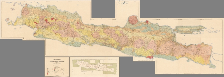


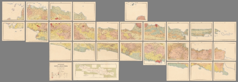
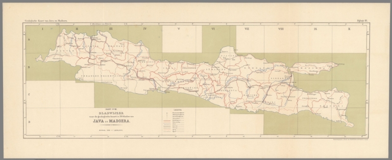


![SSSRI Nazirlər Soveti Yaninda Bas Geodeziya və Kartoqrafiya Idarəsi [i.e. The Chief Administration of Geodesy and Cartography Under the Council of Ministers of the USSR]](https://www.davidrumsey.com/rumsey/Size2/RUMSEY~8~1/199/15271000.jpg)
![SSSRI Nazirlər Soveti Yaninda Bas Geodeziya və Kartoqrafiya Idarəsi [i.e. The Chief Administration of Geodesy and Cartography Under the Council of Ministers of the USSR]](https://www.davidrumsey.com/rumsey/Size2/RUMSEY~8~1/199/15272000.jpg)