|
REFINE
Browse All : Geology and Roads
1-10 of 10
Author
Raymo, Chet
Full Title
(California, Nevada). (to accompany) A geologic and topographic profile of the United States along interstate 80 : by Chet Raymo. 1982. Printed by Hubbard, Northbrook, IL.
List No
13323.006
Note
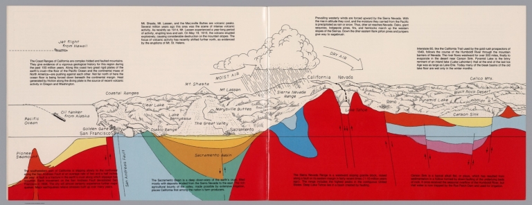
Geologic cross section and map. Covers the area from Pacific Ocean and San Francisco to Carson Sink, showing the volcanic peaks, fault zone, weather system, lakes, drainage, cities and mountains. Includes descriptive text.
Author
Raymo, Chet
Full Title
(New York). (to accompany) A geologic and topographic profile of the United States along interstate 80 : by Chet Raymo. 1982. Printed by Hubbard, Northbrook, IL.
List No
13323.012
Note
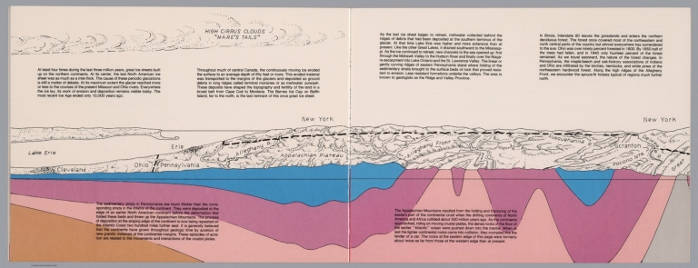
Geologic cross section and topographic map. Covers from Cleveland, Ohio to Delaware. Showing weather system, dunes, ridges and major cities. Includes descriptive text.
Author
Raymo, Chet
Full Title
(Composite). A geologic and topographic profile of the United States along interstate 80 : by Chet Raymo. 1982. Printed by Hubbard, Northbrook, IL.
List No
13323.014
Note
Composite of 8 sheets of geologic cross section and topographic map. Covers the route along Interstate 80 from San Francisco to New York City.
Author
Raymo, Chet
Full Title
(Nevada, Utah). (to accompany) A geologic and topographic profile of the United States along interstate 80 : by Chet Raymo. 1982. Printed by Hubbard, Northbrook, IL.
List No
13323.007
Note
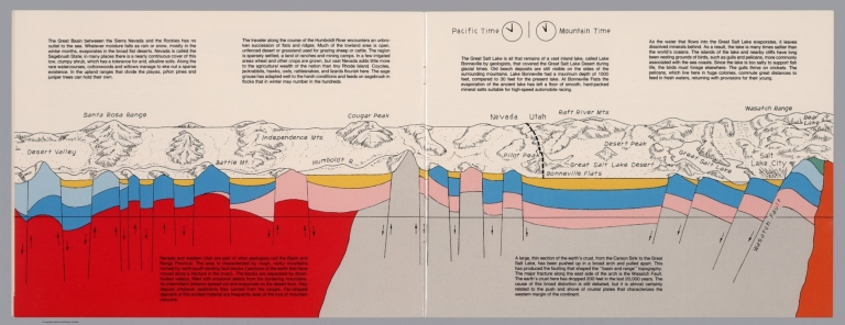
Geologic cross section and map. Covers the Great Basin between Sierra Nevada and the Rockies. Showing the earth's crust from the Carson Sink to the Great Salt Lake. Relief shown pictorially. Includes time zone clocks, showing Pacific standard time and Mountain standard time. Includes descriptive text.
Author
Raymo, Chet
Full Title
(Utah, Wayoming). (to accompany) A geologic and topographic profile of the United States along interstate 80 : by Chet Raymo. 1982. Printed by Hubbard, Northbrook, IL.
List No
13323.008
Note
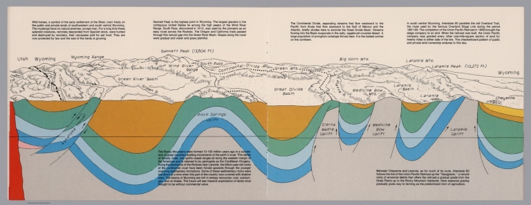
Geologic cross section and map of Utah to Wyoming. Covers the area southwestern and south central Wyoming, showing the earth's crust, drainage and mountains. Relief shown pictorially and spot heights. "In the south central Wyoming, Interstate 80 parallels the Overland Trail". Includes descriptive text.
Author
Raymo, Chet
Full Title
(Great Plains, Nebraska). (to accompany) A geologic and topographic profile of the United States along interstate 80 : by Chet Raymo. 1982. Printed by Hubbard, Northbrook, IL.
List No
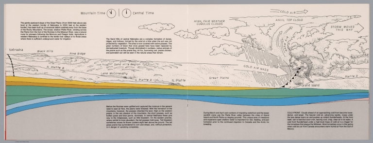
13323.009
Note
Geologic cross section and topographic map of Great Plains, Nebraska. Showing weather system, dunes, ridges and vegetation. Relief shown pictorially. Includes time zone clocks, showing Mountain standard time and Central standard time. Includes descriptive text.
Author
Raymo, Chet
Full Title
(Nebraska, Iowa, Wisconsin). (to accompany) A geologic and topographic profile of the United States along interstate 80 : by Chet Raymo. 1982. Printed by Hubbard, Northbrook, IL.
List No
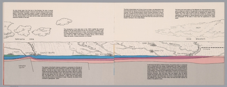
13323.010
Note
Geologic cross section and topographic map. Covers Lincoln, Nebraska to Davenport, Iowa and part of Illinois . Showing weather system, dunes, ridges and major cities. Includes descriptive text.
Author
Raymo, Chet
Full Title
(Illinois, Michigan). (to accompany) A geologic and topographic profile of the United States along interstate 80 : by Chet Raymo. 1982. Printed by Hubbard, Northbrook, IL.
List No
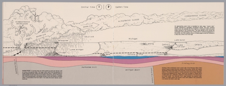
13323.011
Note
Geologic cross section and topographic map. Covers Illinois and Michigan, part of Indiana and Ohio . Showing weather system, dunes, ridges and major cities. Includes time zone clocks, showing Central standard time and Eastern standard time. Includes descriptive text.
Author
Raymo, Chet
Full Title
(New York, Connecticut, Atlantic Ocean). (to accompany) A geologic and topographic profile of the United States along interstate 80 : by Chet Raymo. 1982. Printed by Hubbard, Northbrook, IL.
List No
13323.013
Note
Geologic cross section and topographic map. Covers from Catskill Mts, New York to Atlantic Ocean. Showing weather system, rivers, ridges and major cities. Relief shown by hachures. Includes descriptive text.
Author
Paz Soldan, Mariano Felipe, 1821-1886
Full Title
Linea que representa los temblores sentidos en Arequipa desde hasta 1845. Corte vertical del camino del Pacifico al Huallaga. Corte vertical del camino de Arica al Cuzco. Plano del Pongo de Manseriche. Vista segun el corte vertical. Paz Soldan. Geografia del Peru. Grabado por Delamare, Paris, Calle St. Andre des Arts 45. Paris, Imp. Janson, r. Antne. Dubois, 6. (Paris: Libreria de Augusto Durand, 1865)
List No
4363.068
Note
Lithographed graph, 2 profiles, map and view on sheet. Map shows relief by hachures and landform drawings. Scale of Pongo de Manseriche map (ca. 1:54,000)
1-10 of 10
|