|
REFINE
Browse All : Geology and Physical and Atlas Map of Alaska
1-4 of 4
Author
[Scovel, James L., O'Brien, Emmett J]
Full Title
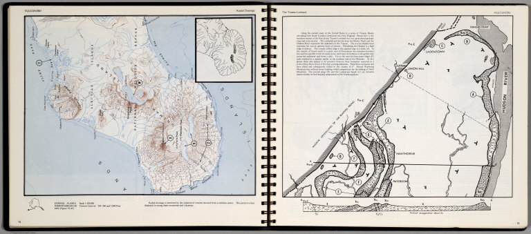
Vulcanism. Radial Drainage. Unimak, Alaska. (on opposite page) The Traiassic Lowland.
List No
0889.040
Note
Contour map, with a cross-section on opposite page. With location map, and text. Relief shown by contours and spot heights. Depth shown by soundings and isolines.
Author
[Scovel, James L., O'Brien, Emmett J]
Full Title
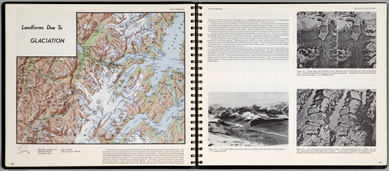
Landforms due to Glaciation. Active Glaciation. Seward, Alaska. (S). (on opposite page) Alpine Glaciation.
List No
0889.056
Note
Color maps with text, and location map. Includes three views of Talkeetna Mountains, Portage Glacier, and Unnamed glacier just north of Spencer glacier. Relief shown by contours and spot heights.
Author
[Geological Survey (U.S.), Denny, Charles Storrow, 1911-]
Full Title
Glacial geology of North America -- Glacial geology representing Alaska -- Glacial geology of conterminous United States / compiled by Charles S. Denny, U. S. Geological Survey, 1965.
List No
14359.055
Note
Three physical maps of North America, the United States and Alaska, featuring glacial geology, as of 1965. Maps show glaciation, political boundaries, bodies of water, drainage, coastlines and islands. Maps include legends, latitudinal and longitudinal lines, as well as bar scales and scale statements. First map presented with Lambert Azimuthal Equal Area Projection; second and third maps with Albers Equal Area Projection. Colored lithograph. Together, maps are 39 x 31 cm, on sheet 49 x 35 cm. Accompanying descriptive text on page 73. Maps appear in Special subject maps section, subsection Physical : Geology.
Author
Berghaus, Hermann
Full Title
Gletscherkarte. Entw. v. Herm. Berghaus 1885, Ausg. 1888. Gez. v. M. Risch. Gest. v. O. Hess, Berge v. F. Kogel. Gotha: Justus Perthes (1892)
List No
1578.006
Note
21 lithographed maps on 1 sheet, color. Relief shown by hachures and spot heights. Contents: Inlandeis des Frederickshaab-Gletschers nach J.A.D. Jensen -- Gronlandisches Binnen-Eis -- Justedals Bra -- Jotun Fjeld -- Berner Oberland -- Gletscher des Halbinsel Kenai (Alaska) -- Aus dem sudlichen Gronland n. G. Holm -- Gletscher des Mount Tacoma (nach dem Northern Transcontinental Survey) von Bailey Willis -- Gletscher des Mount Shasta (nach dem U.S. Geological Survey) von J.S. Diller -- Gletscher von Oisans -- Nevado de Chillan nach A. Philippi -- San Rafael Gletscher -- Oetzthaler Gruppe -- Glockner Gruppe -- Ross-Gletscher (Sud-Georgien) -- Gletscher des Adai Choch (Kaukasus) nach M. v. Dechy -- Hohe von Schneegrenzen und Gletscher-Enden -- Gletscher des Kasbek -- Serafschan Gletscher (Turkestan) nach I.W. Muschketow -- Neuseelandische Alpen nach R. v. Lendenfield.
1-4 of 4
|