|
Author
Berghaus, Hermann
Full Title
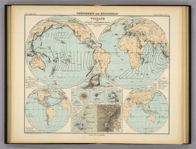
Thatigkeit des Erdinnern. Vulkane und Strand-veranderungen in Mollweide's flachenrechter Erdansicht. Entw. v. Herm. Berghaus 1885, Ausg. 1888. Gotha: Justus Perthes (1892)
List No
1578.003
Note
Lithographed map, color. Ancillary maps: Jan Mayer, nordlichster Vulkan -- Erdbeben-Gebiete westliche -- Ostliche Erdbeben-Gebiete -- Insel Augustin (Tschernabura) -- Stromboli (Liparische Inseln) thatigster Vulkan -- Santorin (Kykladen) -- Sunda Strasse -- Tengger-Gebirge & Semiru.
Author
[Berghaus, Hermann, Luddecke, Richard, Rohrbach, C.]
Full Title
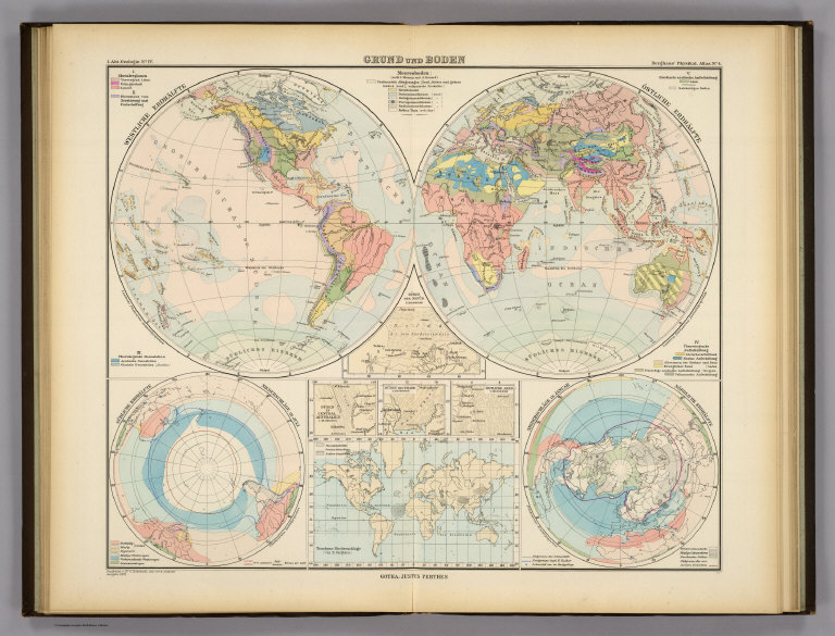
Grund und Boden. Bearbeitet v. Dr. C. Rohrbach, Red. v. Dr. R. Luddecke. Ausgabe 1892. Gotha: Justus Perthes (1892)
List No
1578.004
Note
Lithographed map, color. Ancillary maps: Dunen des Nefud -- Sudliche Erdhalfte, Niederschlage im Juli -- Niederschlage im Januar, Nordliche Erdhalfte -- Dunen in Central Australien -- Dunen des Tharr -- Ostliche Areg -- Trockene Niederschlage.
Author
Berghaus, Hermann
Full Title
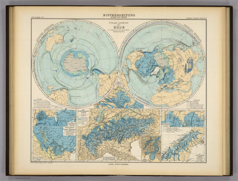
Eisverbreitung, einst und jetzt. Polar Ansicht der Erde in Lambert's flachenrechter Azimuthal-projection. (with) Der Rhein-Gletscher nach A. Favre. (with) Der Rhone Gletscher nach A. Falsan. (with) Seen-Gebiet in Nord-Amerika nach Chamberlin und Wright. (with) Die Europaischen Alpen. (with) Iseo-Gletscher nach Stroppani. (with) Der Loisach- und Inn-Gletscher n. Penck & Bayberger. (with) Die Sudlichen Alpen (Neu-Seeland) nach J. v. Haast. Entw. v. Herm. Berghaus 1884, Ausg. 1886. Gotha: Justus Perthes (1892)
List No
1578.005
Note
Lithographed map, color.
Author
Berghaus, Hermann
Full Title
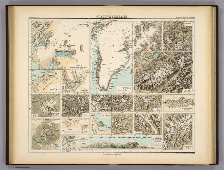
Gletscherkarte. Entw. v. Herm. Berghaus 1885, Ausg. 1888. Gez. v. M. Risch. Gest. v. O. Hess, Berge v. F. Kogel. Gotha: Justus Perthes (1892)
List No
1578.006
Note
21 lithographed maps on 1 sheet, color. Relief shown by hachures and spot heights. Contents: Inlandeis des Frederickshaab-Gletschers nach J.A.D. Jensen -- Gronlandisches Binnen-Eis -- Justedals Bra -- Jotun Fjeld -- Berner Oberland -- Gletscher des Halbinsel Kenai (Alaska) -- Aus dem sudlichen Gronland n. G. Holm -- Gletscher des Mount Tacoma (nach dem Northern Transcontinental Survey) von Bailey Willis -- Gletscher des Mount Shasta (nach dem U.S. Geological Survey) von J.S. Diller -- Gletscher von Oisans -- Nevado de Chillan nach A. Philippi -- San Rafael Gletscher -- Oetzthaler Gruppe -- Glockner Gruppe -- Ross-Gletscher (Sud-Georgien) -- Gletscher des Adai Choch (Kaukasus) nach M. v. Dechy -- Hohe von Schneegrenzen und Gletscher-Enden -- Gletscher des Kasbek -- Serafschan Gletscher (Turkestan) nach I.W. Muschketow -- Neuseelandische Alpen nach R. v. Lendenfield.
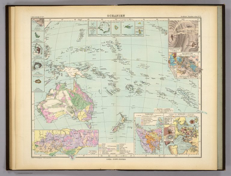
Author
Berghaus, Hermann
Full Title
Oceanien. (with) Victoria nach Brough Smyth. (with) Tasmanien nach R.M. Johnston und C.P. Sprent. (with) Landenge von Auckland n.v. Hochstetter. (with) Das Seenland (Neu-Seeland) nach d. 10. Juni 1886. (with) Hawaii-Vulkane veranderungen bis 1886. Entw. v. H. Berghaus 1886, Ausg. 1888. Gotha: Justus Perthes (1892)
List No
1578.014
Note
Lithographed geologic map, color, with 19 insets. Small inset maps not given in full title: Honolulu (Sandwich-Inseln) -- Makatea (Tuamotu-Gruppe) -- Bolabola (Gesellschafts-Inseln) -- Totoya (Viti-Inseln) -- Niuafu (Tonga-Inseln) -- Tova Riff (Viti In.) -- Vuata Vatua (Ono In.) -- Nukufetau (der Ellice Gruppe) -- Taiara (Tuamotu In.) -- Washington -- Jervis -- Enderbury (Phoenix In.) -- Roto-Mahana der warme See vor d. 10. Juni 1886 -- Maunga Rei.
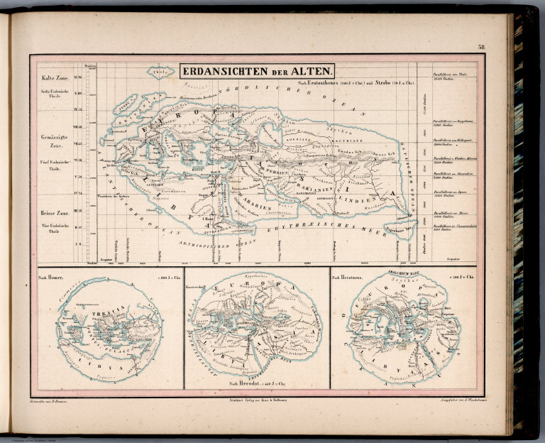
Author
Bromme, Traugott
Full Title
38. Erdansichten der Alten. Nach Eratosthenes (200 J. v. Chr.) und Strabo (20 J. n. Chr.). Entworfen von Tr. Bromme. Ausgefuhrt v. E. Winckelmann. Stuttgart. Verlag von Krais & Hoffman. (to accompany) Atlas zur Physik der Welt. (with second title page) Atlas zu Alex. v. Humboldt's Kosmos ... Bromme. (with 3 insets).
List No
1615.043
Note
Outline color map, with insets. Showing the Earth in ancient history.
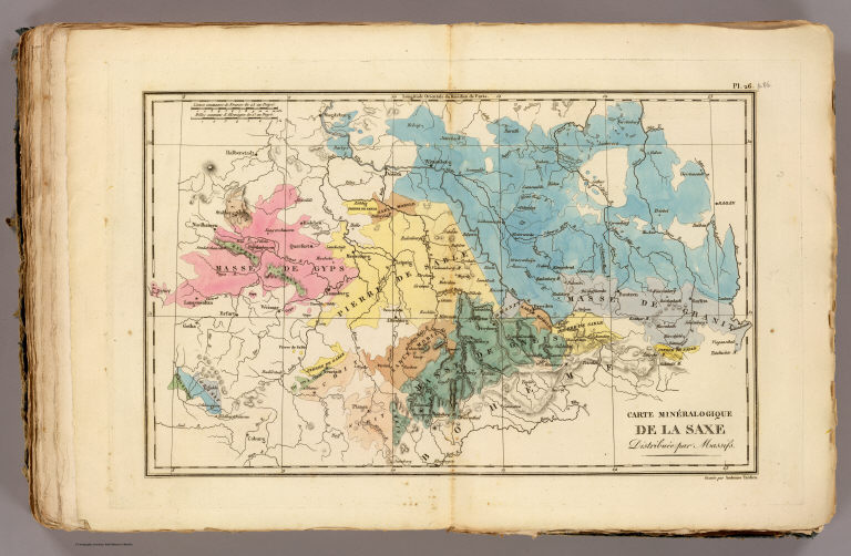
Author
[Bory de Saint-Vincent, M. (Jean Baptiste GeneviFve Marcellin), 1778-1846, Desmarest, Nicolas, 1725-1815, Vincent]
Full Title
Carte mineralogique de la Saxe. Distribuee par massifs. Gravee par Ambroise Tardieu. (A Paris, Chez Mme. veuve Agasse, Imprimeur-Libraire, rue des Poitevins, no. 6. M.DCCCXXVII)
List No
1801.025
Note
Hand col. Engraved map. Relief shown by hachures. Shows geology. David Rumsey Collection copy has "p. 86" added in pencil.
Author
[Bory de Saint-Vincent, M. (Jean Baptiste GeneviFve Marcellin), 1778-1846, Desmarest, Nicolas, 1725-1815, Vincent]
Full Title
Coupe perpendiculaire d'un point du Plateau de St. Pierre. Grande entree sous le Fort St. Pierre, vue de la route de Kanne. Entree de cryptes sous Lichtenberg, avec les orgues geologiques qu'on y voit. Dessine par Bory de St. Vincent. Grave par Ambroise Tardieu. (A Paris, Chez Mme. veuve Agasse, Imprimeur-Libraire, rue des Poitevins, no. 6. M.DCCCXXVII)
List No
1801.027
Note
Engraved cross section and 2 views. Numbered 1-3.
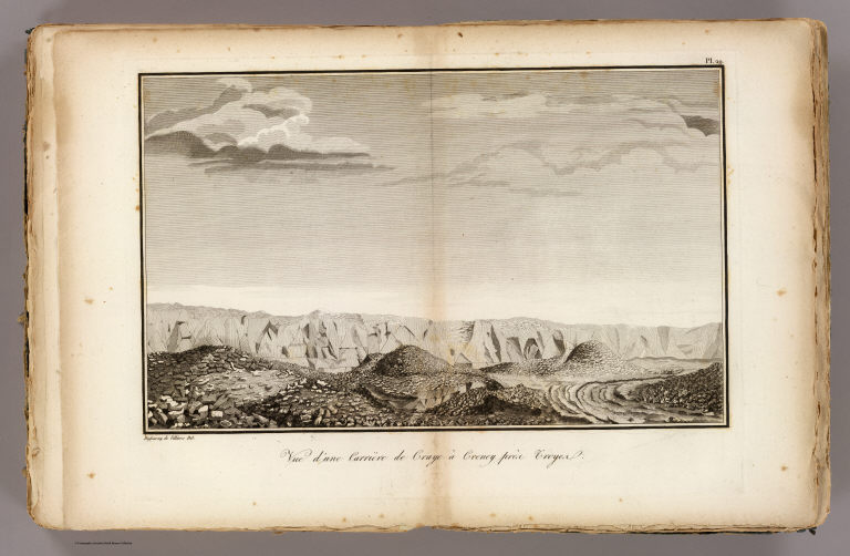
Author
[Bory de Saint-Vincent, M. (Jean Baptiste GeneviFve Marcellin), 1778-1846, Desmarest, Nicolas, 1725-1815, Vincent]
Full Title
Vue d'une carriere de craye a Creney pres Troyes. Dufourny de Villiers del. (A Paris, Chez Mme. veuve Agasse, Imprimeur-Libraire, rue des Poitevins, no. 6. M.DCCCXXVII)
List No
1801.028
Note
Engraved view.
Author
[Bory de Saint-Vincent, M. (Jean Baptiste GeneviFve Marcellin), 1778-1846, Desmarest, Nicolas, 1725-1815, Vincent]
Full Title
Premier age du Volcan de Mascareigne en 1760. Cratere et sommet du Vesuve le 29 Octobre 1767. Grave par Ambroise Tardieu. (A Paris, Chez Mme. veuve Agasse, Imprimeur-Libraire, rue des Poitevins, no. 6. M.DCCCXXVII)
List No
1801.033
Note
Two engraved views.
Author
[Bory de Saint-Vincent, M. (Jean Baptiste GeneviFve Marcellin), 1778-1846, Desmarest, Nicolas, 1725-1815, Vincent]
Full Title
Cratere du Mont Vesuve, avant l'eruption de 1767. Cratere Dolomieu, Ile de Mascareigne, dans la nuit du 27 au 28 Octobre 1801. Grave par Ambroise Tardieu. (A Paris, Chez Mme. veuve Agasse, Imprimeur-Libraire, rue des Poitevins, no. 6. M.DCCCXXVII)
List No
1801.034
Note
Two engraved views.
Author
[Bory de Saint-Vincent, M. (Jean Baptiste GeneviFve Marcellin), 1778-1846, Desmarest, Nicolas, 1725-1815, Vincent]
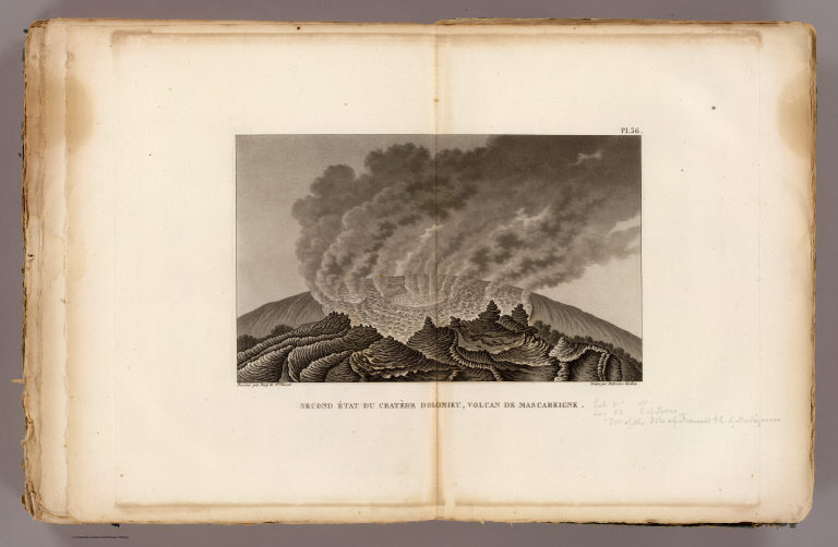
Full Title
Second etat du cratere Dolomieu, volcan de Mascareigne. Dessine par Bory de St. Vincent. Grave par Ambroise Tardieu. (A Paris, Chez Mme. veuve Agasse, Imprimeur-Libraire, rue des Poitevins, no. 6. M.DCCCXXVII)
List No
1801.035
Note
Engraved view. David Rumsey Collection copy has annotations in pencil.
Author
[Bory de Saint-Vincent, M. (Jean Baptiste GeneviFve Marcellin), 1778-1846, Desmarest, Nicolas, 1725-1815, Vincent]
Full Title
Mamelon Central, volcan de Mascareigne. Cratere Bory, volcan de Mascareigne. Dessine par Bory de St. Vincent. Grave par Ambroise Tardieu. (A Paris, Chez Mme. veuve Agasse, Imprimeur-Libraire, rue des Poitevins, no. 6. M.DCCCXXVII)
List No
1801.036
Note
Two engraved views.
Author
[Bory de Saint-Vincent, M. (Jean Baptiste GeneviFve Marcellin), 1778-1846, Desmarest, Nicolas, 1725-1815, Vincent]
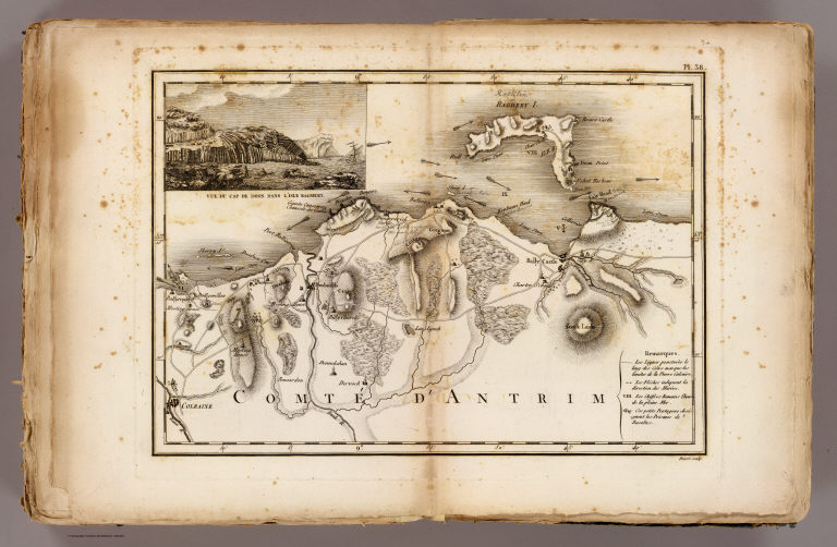
Full Title
Comte d'Antrim. (with) Vue du Cap de Doon dans l'isle Raghery. Poiret sculp. (A Paris, Chez Mme. veuve Agasse, Imprimeur-Libraire, rue des Poitevins, no. 6. M.DCCCXXVII)
List No
1801.037
Note
Engraved map. Relief shown by hachures. Shows roads, harbors, submerged limestone, columnar basalt, currents, etc. David Rumsey Collection copy includes annotations in pencil.
Author
[Bory de Saint-Vincent, M. (Jean Baptiste GeneviFve Marcellin), 1778-1846, Desmarest, Nicolas, 1725-1815, Vincent]
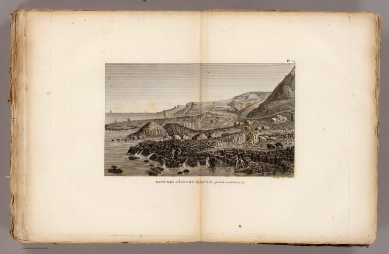
Full Title
Pave des Geans en Irlande, cote occidental. Grave par Ambroise Tardieu. (A Paris, Chez Mme. veuve Agasse, Imprimeur-Libraire, rue des Poitevins, no. 6. M.DCCCXXVII)
List No
1801.038
Note
Engraved view. Includes human figures and boats.
Author
[Bory de Saint-Vincent, M. (Jean Baptiste GeneviFve Marcellin), 1778-1846, Desmarest, Nicolas, 1725-1815, Vincent]
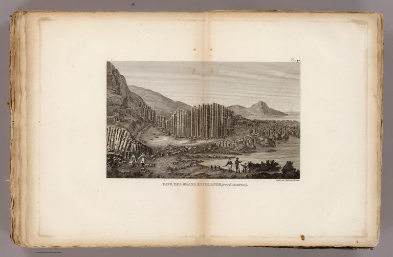
Full Title
Pave des Geans en Irlande, cote oriental. Grave par Ambroise Tardieu. (A Paris, Chez Mme. veuve Agasse, Imprimeur-Libraire, rue des Poitevins, no. 6. M.DCCCXXVII)
List No
1801.039
Note
Engraved view. Includes human figures.
Author
[Bory de Saint-Vincent, M. (Jean Baptiste GeneviFve Marcellin), 1778-1846, Desmarest, Nicolas, 1725-1815, Vincent]
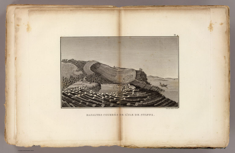
Full Title
Basaltes courbes de l'Ile de Staffa. Grave par Ambroise Tardieu. (A Paris, Chez Mme. veuve Agasse, Imprimeur-Libraire, rue des Poitevins, no. 6. M.DCCCXXVII)
List No
1801.040
Note
Engraved view. Includes human figures and boats.
Author
[Bory de Saint-Vincent, M. (Jean Baptiste GeneviFve Marcellin), 1778-1846, Desmarest, Nicolas, 1725-1815, Vincent]
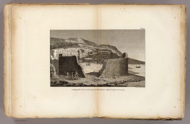
Full Title
Cirque volcanique d'Ashna Crogs, Ile de Mull. Grave par Ambroise Tardieu. (A Paris, Chez Mme. veuve Agasse, Imprimeur-Libraire, rue des Poitevins, no. 6. M.DCCCXXVII)
List No
1801.041
Note
Engraved view. Includes human figures and boat.
Author
[Bory de Saint-Vincent, M. (Jean Baptiste GeneviFve Marcellin), 1778-1846, Desmarest, Nicolas, 1725-1815, Vincent]
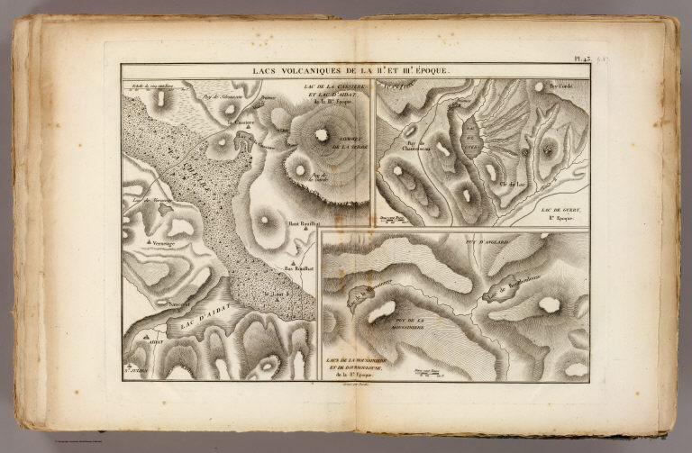
Full Title
Lacs volcaniques de la IIe. et IIIe. epoque. Grave par Berthe. (A Paris, Chez Mme. veuve Agasse, Imprimeur-Libraire, rue des Poitevins, no. 6. M.DCCCXXVII)
List No
1801.042
Note
Three engraved maps. Relief shown by hachures. Contents: Lac de la Cassiere et Lac d'Aidat de la IIIe. epoque -- Lac de Guery, IIe. Epoque -- Lacs de la Moussiniere et de Bourboulouse, de la IIe. epoque. David Rumsey Collection copy has "p. 87" added in pencil.
Author
[Bory de Saint-Vincent, M. (Jean Baptiste GeneviFve Marcellin), 1778-1846, Desmarest, Nicolas, 1725-1815, Vincent]
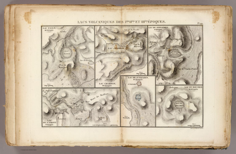
Full Title
Lacs volcaniques de la Iere, IIeme. et IIIeme. epoques. Grave par Ambroise Tardieu. (A Paris, Chez Mme. veuve Agasse, Imprimeur-Libraire, rue des Poitevins, no. 6. M.DCCCXXVII)
List No
1801.043
Note
Six engraved maps. Relief shown by hachures. Contents: Lac Paven, IIIe. epoque -- Lac Chambon, IIIe. epoque -- Lac de Servieres, Ie. epoque -- Lac de St. Front, IIe. epoque -- Lac de St. Paulien, IIe. epoque -- Lac du Bouchet, IIe. epoque.
Author
[Bory de Saint-Vincent, M. (Jean Baptiste GeneviFve Marcellin), 1778-1846, Desmarest, Nicolas, 1725-1815, Vincent]
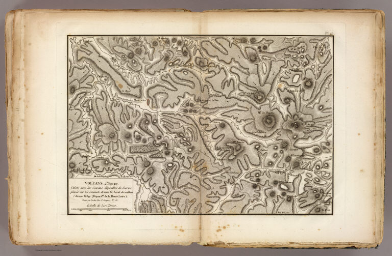
Full Title
Volcans. 2e. epoque. Culots avec les courans depouilles de Scories places sur les sommets de tous les bords des vallons, Ancien Velay, Departnt. de la Haute Loire. Grave par Berthe, Rue St. Jacques, No. 66. (A Paris, Chez Mme. veuve Agasse, Imprimeur-Libraire, rue des Poitevins, no. 6. M.DCCCXXVII)
List No
1801.044
Note
Engraved map. Relief shown by hachures.
Author
[Bory de Saint-Vincent, M. (Jean Baptiste GeneviFve Marcellin), 1778-1846, Desmarest, Nicolas, 1725-1815, Vincent]
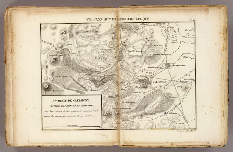
Full Title
Volcans IIIeme. et derniere epoque. Environs de Clermont, crateres de Pariou et de Graveniere, avec leurs courans de lave couverts de Scories, et l'indication des Sources, aux extremites de ces courans. Grave par Ambroise Tardieu. (A Paris, Chez Mme. veuve Agasse, Imprimeur-Libraire, rue des Poitevins, no. 6. M.DCCCXXVII)
List No
1801.045
Note
Engraved map. Relief shown by hachures.
Author
[Bory de Saint-Vincent, M. (Jean Baptiste GeneviFve Marcellin), 1778-1846, Desmarest, Nicolas, 1725-1815, Vincent]
Full Title
Carte conjecturale de l'Atlantide d'apres le Colonel Bory de St. Vincent, dans ses Essais sur les Iles Fortunees. Grave par Berthe. (A Paris, Chez Mme. veuve Agasse, Imprimeur-Libraire, rue des Poitevins, no. 6. M.DCCCXXVII)
List No
1801.046
Note
Engraved map. Relief shown by hachures. Shows modern and ancient names. Prime meridian: Paris. David Rumsey Collection copy has "p. 104 to 108" added in pencil.
Dutton, Clarence E. (Clarence Edward), 1... Map of portions of Utah and Arizona show... 1879 2080.004 Related Author
[Dutton, Clarence E. (Clarence Edward), 1841-1912, Geographical and Geological Survey of the Rocky Mountain Region (U.S.)]
Full Title
Map of portions of Utah and Arizona showing the arrangement of faults and flexures in the Kaibabs and high plateaus. Dept. of the Interior, U.S. G. and G. Survey, J.W. Powell in charge. Atlas sheet no. 4, Geology of the high plateaus of Utah by Capt. C.E. Dutton, U.S.A. (Julius Bien, Lith., New York, 1879)
List No
2080.004
Note
Lithographed map. Relief shown by hachures.
Branner, John Casper; California. State ... Cover: Atlas California earthquake, Apri... 1908 2130A Related Author
[Branner, John Casper, California. State Earthquake Investigation Commission, Gilbert, G. K., Lawson, Andrew C., Reid, Harry Fielding]
Full Title
(Covers to) Atlas of maps and seismograms accompanying the report of the State Earthquake Investigation Commission upon the California earthquake of April 18, 1906. Andrew C. Lawson, G.K. Gilbert, H.F. Reid, J.C. Branner, A.O. Leuschner, George Davidson, Charles Burckhalter, W.W. Campbell. Carnegie Institution of Washington. Washington, D.C. 1908. (seal) Carnegie Institution of Washington 1902.
List No
2130A
Note
Dark green cloth covered boards with the title embossed in gold on the front cover.
Branner, John Casper; California. State ... Title Page: Atlas California earthquake,... 1908 2130B Related Author
[Branner, John Casper, California. State Earthquake Investigation Commission, Gilbert, G. K., Lawson, Andrew C., Reid, Harry Fielding]
Full Title
(Title Page to) Atlas of maps and seismograms accompanying the report of the State Earthquake Investigation Commission upon the California earthquake of April 18, 1906. Andrew C. Lawson, G.K. Gilbert, H.F. Reid, J.C. Branner, A.O. Leuschner, George Davidson, Charles Burckhalter, W.W. Campbell. Carnegie Institution of Washington. Washington, D.C. 1908. (seal) Carnegie Institution of Washington 1902.
List No
2130B
Note
This atlas accompanied several text volumes (David Rumsey Collection has reproductions) and was the most complete mapping of the great earthquake of 1906. Maps printed in full and partial color. Covers are dark green cloth covered boards with the title embossed in gold on the front cover.
Branner, John Casper; California. State ... Contents: Atlas California earthquake, A... 1908 2130C Related Author
[Branner, John Casper, California. State Earthquake Investigation Commission, Gilbert, G. K., Lawson, Andrew C., Reid, Harry Fielding]
Full Title
(Contents to) Atlas of maps and seismograms accompanying the report of the State Earthquake Investigation Commission upon the California earthquake of April 18, 1906. Andrew C. Lawson, G.K. Gilbert, H.F. Reid, J.C. Branner, A.O. Leuschner, George Davidson, Charles Burckhalter, W.W. Campbell. Carnegie Institution of Washington. Washington, D.C. 1908. (seal) Carnegie Institution of Washington 1902.
List No
2130C
Note
Table of contents.
California. State Earthquake Investigati... Geomorphic map, California, Nevada, port... 1908 2130.001 Related Author
California. State Earthquake Investigation Commission
Full Title
Geomorphic map of California and Nevada with portions of Oregon and Idaho showing the diastrophic character of the relief, the steep descent from the sub-continental shelf to the floor of the Pacific, and the more important known faults. Earthquake Investigation Commission. Drawn by M. Solem. A. Hoen & Co., Baltimore. (Carnegie Institution of Washington, 1908)
List No
2130.001
Note
Color. Relief shown by hachures; depths by bathymetric isolines. Shows railways, towns, counties and drainage.
California. State Earthquake Investigati... Coast of California showing San Andreas ... 1908 2130.002 Related Author
California. State Earthquake Investigation Commission
Full Title
Map of a portion of the coast of California showing the San Andreas Rift from Point Arena to Fort Ross and the trace of the fault of April 18, 1906. Earthquake Investigation Commission. Julius Bien & Co., N.Y. (Carnegie Institution of Washington. 1908)
List No
2130.002
Note
Color. Also shows settlements, townships and sections, roads and drainage. "Compiled from the official maps of Sonoma and Mendocino Counties."
Author
[California. State Earthquake Investigation Commission, Matthes, Francois E.]
Full Title
Detail map of a typical portion of the San Andreas Rift near Fort Ross, Sonoma County, California showing its geomorphic features and the trace of the fault by Francois E. Matthes. Earthquake Investigation Commission. A. Hoen & Co., Baltimore. (Carnegie Institution of Washington. 1908)
List No
2130.003
Note
Color. Contour interval 5 ft. Shows roads, trails, houses, fences, ponds, streams, marshes, etc. Inset: Index map.
California. State Earthquake Investigati... San Francisco Bay showing San Andreas Ri... 1908 2130.004 Related Author
California. State Earthquake Investigation Commission
Full Title
Map of the region about San Francisco Bay showing the relation of the city of San Francisco to the San Andreas Rift, the fault of April 18, 1906 and the fault of October 21, 1868. Earthquake Investigation Commission. Julius Bien & Co., Lith., N.Y. (Carnegie Institution of Washington. 1908)
List No
2130.004
Note
Color. Relief shown by contours and spot heights; depths by soundings and isoline. "Topography by the C. and G. Survey and the U.S. Geological Survey."
California. State Earthquake Investigati... Coast Ranges showing San Andreas Rift. 1908 2130.005 Related Author
California. State Earthquake Investigation Commission
Full Title
Map of a portion of the Coast Ranges of California showing the San Andreas Rift. Earthquake Investigation Commission. Julius Bien & Co., Lith., N.Y. (Carnegie Institution of Washington. 1908)
List No
2130.005
Note
Color. Contour interval 500 ft. Shows settlements, railroads, etc.
California. State Earthquake Investigati... Mt. Pinos quadrangle showing San Andreas... 1908 2130.006 Related Author
[California. State Earthquake Investigation Commission, U.S. Geological Survey]
Full Title
California, Mt. Pinos quadrangle of the U.S. Geological Survey showing the San Andreas Rift. Earthquake Investigation Commission. (Carnegie Institution of Washington. 1908)
List No
2130.006
Note
Color. 30-minute topographic quadrangle. Relief shown by contours and spot heights. Covers portions of Ventura, Kern and Santa Barbara counties.
California. State Earthquake Investigati... Tejon quadrangle showing San Andreas Rif... 1908 2130.007 Related Author
[California. State Earthquake Investigation Commission, U.S. Geological Survey]
Full Title
California, Tejon quadrangle of the U.S. Geological Survey showing the San Andreas Rift. Earthquake Investigation Commission. (Carnegie Institution of Washington. 1908)
List No
2130.007
Note
Color. 30-minute topographic quadrangle. Relief shown by contours and spot heights. Covers portions of Kern, Los Angeles and Ventura counties.
California. State Earthquake Investigati... Palmdale quadrangle showing San Andreas ... 1908 2130.008 Related Author
[California. State Earthquake Investigation Commission, U.S. Geological Survey]
Full Title
California, Palmdale quadrangle of the U.S. Geological Survey showing the San Andreas Rift. Earthquake Investigation Commission. A. Hoen & Co., Baltimore. (Carnegie Institution of Washington. 1908)
List No
2130.008
Note
Color. 30-minute topographic quadrangle. Relief shown by contours and spot heights. Covers portions of Kern and Los Angeles counties.
California. State Earthquake Investigati... Rock Creek quadrangle showing San Andrea... 1908 2130.009 Related Author
[California. State Earthquake Investigation Commission, U.S. Geological Survey]
Full Title
California, Rock Creek quadrangle of the U.S. Geological Survey showing the San Andreas Rift. Earthquake Investigation Commission. Andrew B. Graham Co., Lithographers, Washington, D.C. (Carnegie Institution of Washington. 1908)
List No
2130.009
Note
Color. 15-minute topographic quadrangle. Relief shown by contours and spot heights. In Los Angeles County.
California. State Earthquake Investigati... San Antonio quadrangle showing San Andre... 1908 2130.010 Related Author
[California. State Earthquake Investigation Commission, U.S. Geological Survey]
Full Title
California, San Antonio quadrangle of the U.S. Geological Survey showing the San Andreas Rift. Earthquake Investigation Commission. Andrew B. Graham Co., Lithographers, Washington, D.C. (Carnegie Institution of Washington. 1908)
List No
2130.010
Note
Color. 15-minute topographic quadrangle. Relief shown by contours and spot heights. Covers portions of Los Angeles and San Bernardino counties.
California. State Earthquake Investigati... Hesperia quadrangle showing San Andreas ... 1908 2130.011 Related Author
[California. State Earthquake Investigation Commission, U.S. Geological Survey]
Full Title
California, Hesperia quadrangle of the U.S. Geological Survey showing the San Andreas Rift. Earthquake Investigation Commission. Andrew B. Graham Co., Lithographers, Washington, D.C. (Carnegie Institution of Washington. 1908)
List No
2130.011
Note
Color. 15-minute topographic quadrangle. Relief shown by contours and spot heights. Covers portion of San Bernardino County.
California. State Earthquake Investigati... San Bernardino quadrangle showing San An... 1908 2130.012 Related Author
[California. State Earthquake Investigation Commission, U.S. Geological Survey]
Full Title
California, San Bernardino quadrangle of the U.S. Geological Survey showing the San Andreas Rift. Earthquake Investigation Commission. Andrew B. Graham Co., Lithographers, Washington, D.C. (Carnegie Institution of Washington. 1908)
List No
2130.012
Note
Color. 15-minute topographic quadrangle. Relief shown by contours and spot heights. Covers portions of San Bernardino and Riverside counties.
California. State Earthquake Investigati... Redlands quadrangle showing San Andreas ... 1908 2130.013 Related Author
[California. State Earthquake Investigation Commission, U.S. Geological Survey]
Full Title
California, Redlands quadrangle of the U.S. Geological Survey showing the San Andreas Rift. Earthquake Investigation Commission. Andrew B. Graham Co., Lithographers, Washington, D.C. (Carnegie Institution of Washington. 1908)
List No
2130.013
Note
Color. 15-minute topographic quadrangle. Relief shown by contours and spot heights. Covers portions of San Bernardino and Riverside counties.
California. State Earthquake Investigati... San Gorgonio quadrangle showing San Andr... 1908 2130.014 Related Author
[California. State Earthquake Investigation Commission, U.S. Geological Survey]
Full Title
California, San Gorgonio quadrangle of the U.S. Geological Survey showing the San Andreas Rift and the Mission Creek Fault. Earthquake Investigation Commission. Andrew B. Graham Co., Lithographers, Washington, D.C. (Carnegie Institution of Washington. 1908)
List No
2130.014
Note
Color. 30-minute topographic quadrangle. Relief shown by contours and spot heights. Covers portions of San Bernardino and Riverside counties.
California. State Earthquake Investigati... San Jacinto quadrangle showing San Andre... 1908 2130.015 Related Author
[California. State Earthquake Investigation Commission, U.S. Geological Survey]
Full Title
California, San Jacinto quadrangle of the U.S. Geological Survey showing the San Andreas Rift, the Mission Creek Fault and the San Jacinto Fault. Earthquake Investigation Commission. Andrew B. Graham Co., Lithographers, Washington, D.C. (Carnegie Institution of Washington. 1908)
List No
2130.015
Note
Color. 30-minute topographic quadrangle. Relief shown by contours and spot heights. Covers portions of Riverside County.
California. State Earthquake Investigati... Santa Rosa, portions destroyed by earthq... 1908 2130.016 Related Author
California. State Earthquake Investigation Commission
Full Title
Map of the city of Santa Rosa, Sonoma County, California showing the portions destroyed by the earthquake of April 18, 1906, and by the fire consequent thereto. Earthquake Investigation Commission. A. Hoen & Co., Baltimore. (Carnegie Institution of Washington. 1908)
List No
2130.016
Note
Relief shown by hachures. Shows buildings destroyed by earthquake and following fire.
California. State Earthquake Investigati... San Mateo quadrangle showing intensity, ... 1908 2130.021 Related Author
[California. State Earthquake Investigation Commission, U.S. Geological Survey]
Full Title
California, San Mateo quadrangle of the U.S. Geological Survey showing the distribution of apparent intensity, the known faults, and the routes examined. Earthquake Investigation Commission. A. Hoen & Co., Baltimore. (Carnegie Institution of Washington. 1908)
List No
2130.021
Note
Color. 15-minute topographic quadrangle. Relief shown by contours and spot heights. Covers portions of San Mateo and San Francisco counties. Rossi-Forel scale.
California. State Earthquake Investigati... Santa Cruz quadrangle showing intensity,... 1908 2130.022 Related Author
[California. State Earthquake Investigation Commission, U.S. Geological Survey]
Full Title
California, Santa Cruz quadrangle of the U.S. Geological Survey showing the distribution of apparent intensity, the known faults, the routes examined and the numbered localities referred to in the text. Earthquake Investigation Commission. A. Hoen & Co., Baltimore. (Carnegie Institution of Washington. 1908)
List No
2130.022
Note
Color. 30-minute topographic quadrangle. Relief shown by contours and spot heights. Covers portions of San Mateo, Santa Clara and Santa Cruz counties. Rossi-Forel scale.
California. State Earthquake Investigati... California, Nevada showing intensity. 1908 2130.023 Related Author
California. State Earthquake Investigation Commission
Full Title
Map of California and Nevada showing the distribution of apparent intensity in the region affected by the earthquake of April 18, 1906. Drawn by M. Solem. Earthquake Investigation Commission. A. Hoen & Co., Baltimore. (Carnegie Institution of Washington. 1908)
List No
2130.023
Note
Color. Covers also parts of Oregon and Idaho. Rossi-Forel scale.
California. State Earthquake Investigati... Coast Range Middle California distributi... 1908 2130.024 Related Author
California. State Earthquake Investigation Commission
Full Title
Map of the Coast Range Region of Middle California showing the distribution of earth movement on April 18, 1906 as revealed by the displacement of the triangulation stations of the Coast and Geodetic Surveyed, determined by resurvey, 1906-07. Drawn by M. Solem. Earthquake Investigation Commission. A. Hoen & Co., Baltimore. (Carnegie Institution of Washington. 1908)
List No
2130.024
Note
Color. Shows fault of 1906, movement of 1906, successive movements of 1868 and 1906, combined movements of 1868 and 1906, railroads, settlements, etc.
California. State Earthquake Investigati... Distribution of earth movement, April 18... 1908 2130.025 Related Author
California. State Earthquake Investigation Commission
Full Title
Distribution of earth movement on April 18, 1906 and in 1868 as revealed by the displacement of the triangulation stations of the Coast and Geodetic Surveyed, determined by resurvey, 1906-07. Earthquake Investigation Commission. A. Hoen & Co., Baltimore. (Carnegie Institution of Washington. 1908)
List No
2130.025
Note
Four color maps. Contents: No. 1. Point Arena and vicinity -- No. 2. Fort Ross and vicinity -- No. 3. Tomales Bay -- No. 4. Colma and vicinity.
Author
California. State Earthquake Investigation Commission
Full Title
Seismograms - sheet no. 1. Earthquake Investigation Commission. (Carnegie Institution of Washington. 1908)
List No
2130.026
Note
Black and white reproductions of April 18, 1906 earthquake from various stations.
Author
California. State Earthquake Investigation Commission
Full Title
Seismograms - sheet no. 2. Earthquake Investigation Commission. (Carnegie Institution of Washington. 1908)
List No
2130.027
Note
Black and white reproductions of April 18, 1906 earthquake from various stations.
|