|
REFINE
Browse All : Geology and Mining from 1864
1-3 of 3
Author
Guillemin-Tarayre, Edmond
Full Title
Carte Panoramique de la Region metallifere de Washoe (Etat de Nevada) par E. Guillemin-Tarayre. Cette carte est executee en projection gnomonique sur l'horizon du Mt. Davidson. Grave chex Erhard, Paris - Impr. Lemercier r. de Seine 57.
List No
11309.000
Note
Early map of Lake Tahoe and the Washoe Mining District on a Gnomonic Projection. One of the earliest geological and mining map of the region. Centered on Virginia City and extending to the Truckee River, Lake Tahoe, the Walker River and the Carson River. The outer ring of mountains locates Sevier Mountain, Pyramid Peak, Mt. Washoe, the Valley of the Carson River, and "Massif Palmyra." Towns named on the map include Washoe City, Fort Churchill, Genoa, Carson, with several dozen mines also named. Relief shown pictorially, by hachures and spot heights. Includes key to geological formation and notes. Guillemin-Tarayre's map is part of a rare set of scientific works published by the French government.
Author
Egloffstein, Baron F.W. von
Full Title
Geological map and profiles of some of the principal mining districts of Mexico. Geographical Institute, Baron F.W. Von Egloffstein, No. 164 Broadway N. York. Lettering by Oliver J. Stuart, N.Y. Entered ... 1864, by F.W. von Egloffstein ... New York. Printed by W. Pate. (with) The Geological profiles. (to accompany) Contributions to the Geology and the Physical Geography of Mexico, including a Geological and Topographical Map ... 1864.
List No
5521.007
Note
Uncolored engraved topographical map. With 13 Profiles. Shows major cites, volcanoes, lakes, etc. Note: "The geological profiles constructed from altitudes obtained by series of barometrical observations made along the lines indicated in white"... Includes reference. Relief shown by shadings and spot heights. Prime meridian is Mexico.
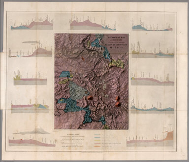
Author
Egloffstein, Baron F.W. von
Full Title
Geological map and profiles of some of the principal mining districts of Mexico. Geographical Institute, Baron F.W. Von Egloffstein, No. 164 Broadway N. York. Lettering by Oliver J. Stuart, N.Y. Entered ... 1864, by F.W. von Egloffstein ... New York. Printed by W. Pate. (with) The Geological profiles. (to accompany) Contributions to the Geology and the Physical Geography of Mexico, including a Geological and Topographical Map ... 1864.
List No
5521.008
Note
Full color engraved geological map. With 13 geological Profiles. Shows major cites, volcanoes, lakes, etc. Note: "The geological profiles constructed from altitudes obtained by series of barometrical observations made along the lines indicated in white"... Includes reference. Relief shown by shadings and spot heights. Prime meridian is Mexico.
1-3 of 3
|