|
Full Title
Coal Resources of the World. West Australia. Map No. 6. Collie Coalfield Longitudinal Section.
List No
2249.010
Note
See 2249.009 for location of cross-section.
Full Title
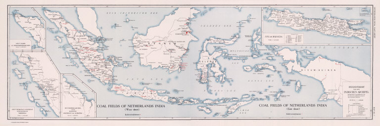
Coal Resources of the World. Coal Fields of Netherlands India. (West Sheet) (East Sheet) Overzichtskaart van den Indischen Archipel. Map No. 7.
List No
2249.011
Note
In Dutch.
Full Title
(Composite) Coal Fields of Netherlands India. Overzichtskaart van den Indischen Archipel. Coal Resources of the World. (inset) Gouvt. Atjeh en Onderhoorigheden. (inset) Gouvt. Sumatra's Westkust en de Residentie Tapanoeli. (inset) Het Noordelijk Deel van de Residentie Oostkust van Sumatra. (inset) Java en Madoera.
List No
2249.012
Full Title
Coal Resources of the World. Netherlands India. Map No. 8. Oversichtskaart van het Ombilin Kolenveld.
List No
2249.013
Note
In Dutch.
Full Title
Coal Resources of the World. China. Map No. 9. Map Showing Distribution of Coal in China.
List No
2249.014
Note
Coal mapped in color.
Full Title
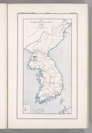
Coal Resources of the World. Corea. Map No. 10. Plate I. Map Showing the Distribution of Coal in Corea.
List No
2249.015
Note
Coal in color.
Author
[Kawasaki, H., Tamura, E.]
Full Title
Coal Resources of the World. Corea. Map No. 11. Plate II. Phyong-Yang Coal Field after H. Kawasaki, E. Tamura.
List No
2249.016
Note
In color.
Author
[Ogawa, T., Kido, C.]
Full Title
Coal Resources of the World. Manchuria. Map No. 12. Plate I. Map Showing Showing the Distribution of Coal in Manchuria. (inset) Hsing-King. Plate II. Fu-Shun Coal Field. After T. Ogawa and C. Kido.
List No
2249.017
Note
Two maps on one sheet. Fu-Shun map at 1:85,000.
Full Title
Coal Resources of the World. Manchuria. Map No. 13. Plate III. Section of Coal Seams in Fu-Shun Coal Fields.
List No
2249.018
Full Title
Coal Resources of the World. Japan. Map No. 14. Plate I. Map Showing the Distribution of Coal in Japan. (inset) (Vicinity map of Japan in Asia). (inset) Taiwan.
List No
2249.019
Note
Coal areas shown in color.
Author
Oinouye, Y.
Full Title
Coal Resources of the World. Japan. Map No. 15. Plate II. Ishikari Coal Fields. After Y. Oinouye.
List No
2249.020
Note
Color.
Author
[Kido, C., Suzuki, F., Matsuda, S.]
Full Title
Coal Resources of the World. Japan. Map No. 16. Plate III. Chikuho Coal Field. After F. Suzuki, C. Kido and S. Matsuda.
List No
2249.021
Author
Otsuki, Y.
Full Title
Coal Resources of the World. Japan. Map No. 17. Plate IV. Karatsu and Sasebo Coal Fields. After Y. Otsuki.
List No
2249.022
Note
Coal fields in color.
Full Title
Coal Resources of the World. India. Map No. 18. Coal Fields of India and Adjacent Countries.
List No
2249.023
Note
Coal fields in color.
Full Title
Coal Resources of the World. Turkey. Map No. 19. Asiatic Turkey Showing Location of Known Coal Fields.
List No
2249.024
Note
Coal field locations shown in color.
Full Title
Coal Resources of the World. South Africa. Map No. 20. Section across the Witbank Coalfield.
List No
2249.025
Author
Dowling, D.B.
Full Title
Coal Resources of the World. Canada. Map No. 21. Plate 1. Coal Areas of Canada by D.B. Dowling.
List No
2249.026
Note
Coal areas in color.
Full Title
Coal Resources of the World. Canada. Map No. 22. Plate 2. Coal Fields of Nova Scotia, New Brunswick, Canada.
List No
2249.027
Note
Coal fields shown in color.
Full Title
Coal Resources of the World. Canada. Map No. 23. Plate 3. Sydney Coal Field.
List No
2249.028
Note
Coal shown in color.
Full Title
Coal Resources of the World. Canada. Map No. 27. Plate 8. Southern Vancouver Island, British Columbia.
List No
2249.029
Note
Coal fields in color.
Author
Campbell, Marius R.
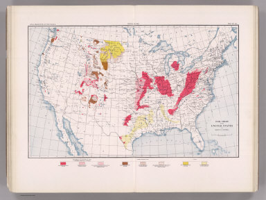
Full Title
Coal Resources of the World. United States. Map No. 28. Coal Fields of the United States by Marius R. Campbell.
List No
2249.030
Note
Coal fields shown in color.
Author
Strahan, A.
Full Title
Coal Resources of the World. England and Wales. Map No. 29. Map Showing Visible and Proved Coal Fields of England and Wales prepared under the direction of A. Strahan at the Geological Survey of Great Britain. London 1912.
List No
2249.031
Note
Coal fields in color.
Full Title
Coal Resources of the World. France. Map No. 30. Fig. 2. Carte du Bassin Houiller de Valenciennes. Fig. 3. Coupe E E Passant par Quievrechain. Fig. 4. Coupe D D Passant par Denain. Fig. 5. Coupe C C Passant par l'Escarpelle. Fig. 6. Coupe B B Passant par Meurchin, Lens et Lievin.
List No
2249.032
Note
Scale varies.
Full Title
Coal Resources of the World. France. Map No. 31. Fig. 7. Coupe A A Passant par Bruay. Fig 8. Coupe de Bassin du Boulonnais.... Fig. 10. Carte du Bassin de Ronchamp. Fig. 11. Carte du Bassin de Saint Etienne. Fig. 12. Coupe Transversale du Bassin de Saint-Etienne. Fig. 13. Carte des Bassins de Blanzy, Le Creusot Bert et Forges.
List No
2249.033
Note
Scale varies.
Full Title
Coal Resources of the World. France. Map No. 32. Fig. 14. Carte du Bassin d'Autun - Epinac. Fig. 15. Carte du Bassin de Decize. Fig. 16. Bassins de Commentry, Doyet l'Aumance et Noyant. Fig. 17. Coupe du Gisement de Saint Eloy.
List No
2249.034
Note
Scale varies.
Full Title
Coal Resources of the World. France. Map No. 33. Fig. 18. Carte du Bassin d'Aubin-Decazeville. Fig. 19. Coupe A B du Bassin d'Aubin-Decazeville. Fig. 20. Carte du Bassin de Carmaux-Albi. Fig. 21. Coupe du Bassin de Carmaux-Albi. Fig. 22. Carte du Bassin de Graissessac.
List No
2249.035
Full Title
Coal Resources of the World. France. Map No. 34. Fig. 23. Carte du Bassin d'Alais. Fig. 24. Coupe du Bassin d'Alais par Molieres et la Grand Combe. Fig. 25. Carte Geologique de la Region de la Mure.
List No
2249.036
Note
Scales vary. Color.
Full Title
Coal Resources of the World. France. Map No. 35. Fig. 26. Carte du Bassin de Fuveau. Fig. 27. Coupe S T du Bassin de Fuveau.
List No
2249.037
Note
In color.
Author
de Pann, Charles
Full Title
Coal Resources of the World. Hungary. Map No. 36. Carte des gisements houillers de la Hongrie par Charles de Pann docteur es sciences, 1912. A.M. Foldtani Tarsulat Tulajdona. Metsz. es Nyomt. Posner K. L. es FIA, terkepeszeti muintezete, Budapesten.
List No
2249.038
Note
Coal fields in color.
Author
Petrascheck, W.
Full Title
Coal Resources of the World. Austria. Map No. 37. Karte 1. Ubersichtskarte der Kphlenlager van Oesterreich bearbeitet von Dr. W. Petrascheck.
List No
2249.039
Note
Coal fields in color.
Author
Petrascheck, W.
Full Title
Coal Resources of the World. Austria. Map No. 38. Karte 2. Karte des Trifailer Braunkohlenrevieres ... W. Petrascheck.
List No
2249.040
Author
Petrascheck, W.
Full Title
Coal Resources of the World. Austria. Map No. 39. Karte 3. Ubersichtskarte de Voitsberg - Koflacher Braunkohlenrevieres ... W. Petrascheck.
List No
2249.041
Author
Petrascheck, W.
Full Title
Coal Resources of the World. Austria. Map No. 40. Karte 4. Uebersichts Karte des Teplitz-Brux-Komotauer Braunkohlenrevieres ... W. Petrascheck. Flotz-Profil....
List No
2249.042
Note
Color.
Author
Frieser, A.
Full Title
Coal Resources of the World. Austria. Map No. 41. Karte 5. Flotzkarten des Falkenau-Elbogen-Karlsbader Braunkohlenrevieres ... A. Frieser. Antono Flotz. Agnes Flotz. Josefi Flotz.
List No
2249.043
Author
Frieser, A.
Full Title
Coal Resources of the World. Austria. Map No. 42. Karte 6. Flotzlagerung in den Egerer Braunkohlenmulden ... A. Frieser.
List No
2249.044
Author
Petrascheck, W.
Full Title
Coal Resources of the World. Austria. Map No. 43. Karte 7. Ubersichtskarte des Kladno-Rakonitzer Steinkohlenrevieres ... W. Petrascheck.
List No
2249.045
Note
In color.
Author
Petrascheck, W.
Full Title
Coal Resources of the World. Karte 8. Map No. 44. Karte des Ostrau - Karwin - Krakauer Steinkohlenrevieres entworfen von W. Petrascheck.
List No
2249.046
Note
In color.
Author
Milojkovitch, J.A.
Full Title
Coal Resources of the World. Servia. Map No. 45. Ubersichtskarte der Kohlenvorkommen im Konigreiche Serbien von J.A. Milojkovitch.
List No
2249.047
Full Title
Coal Resources of the World. Roumania. Map No. 46. Esquisse de la distribution des Charbons en Roumanie.
List No
2249.048
Author
Erdmann, Edvard
Full Title
Coal Resources of the World. Sweden. Map No. 47. Geological Map of Skane Compiled by Edvard Erdmann. 1909.
List No
2249.049
Author
[Nathorst, A.G., De Geer, Backlund, Bruce, Hoel]
Full Title
Coal Resources of the World. Spitzbergen (Norway). Map No. 48. Geological Map of Spitzbergen from the Maps of Nordenskiold, De Geer, Tschernyschew, Backlund, Bruce, Hoel, and personal observations by A.G. Nathorst.
List No
2249.050
Note
Color.
Author
[Hitchcock, Charles H. (Charles Henry), 1836-1919, New Hampshire. Geological Survey]
Full Title
(Title Page to) Atlas accompanying the report on the geology of New Hampshire. C.H. Hitchcock, State Geologist. 1878. Julius Bien, New York.
List No
3095A
Note
17 maps and plates as called for in Vol III, p.vii of text. Huge folio atlas with 2 plates of views, 2 facsimiles (Carrigain 1816 and Holland 1784), 1 diagram or Camera view, a 6 sheet Geological Map of the state, a 5 (of 6, as issued) sheet Map of the state's Surface Geology, and a map of the Ammonoosuc Mining District. The upper northwest sheet of the Surface Geology map was not printed because it is entirely of Vermont, except for a tiny part of the lower right corner which was covered by making the uppper northeast sheet about one inch wider in the Surface Geology issue than it is in the Geological (six sheet) issue. The matter is further confused by Sabin calling for 16 plates and Phillips and LeGear calling for 9. Cobb calls for 17 and the most important list, in the text of the report itself, calls for 17. We believe this was the only large folio Geological Atlas made of an eastern state, on the scale of the western survey atlases of Powell, Hayden, Wheeler and King, during the same period. Most maps have printed color although the Ammonoosuc Mining District map is fully hand colored.
Author
[Hitchcock, Charles H. (Charles Henry), 1836-1919, New Hampshire. Geological Survey]
Full Title
(General geological map of New Hampshire, embracing portions of Maine, Vermont, and Quebec. Sheet 1. Julius Bien, New York, 1878)
List No
3095.005
Note
Col. lithographed map. Sheet 1 of 6. Includes explanation and 5 cross sections. Vertical and horizontal scale 2 1/2 miles to an in. Contour inverval 100 ft. Title from Marcou. Explanation is in v. 2, p. 672 of "Geology of New Hampshire."
Author
[Hitchcock, Charles H. (Charles Henry), 1836-1919, New Hampshire. Geological Survey]
Full Title
(General geological map of New Hampshire, embracing portions of Maine, Vermont, and Quebec. Sheet 2. Julius Bien, New York, 1878)
List No
3095.006
Note
Col. lithographed map. Sheet 2 of 6. Includes explanation and 5 cross sections. Vertical and horizontal scale 2 1/2 miles to an in. Contour inverval 100 ft. Title from Marcou. Explanation is in v. 2, p. 672 of "Geology of New Hampshire."
Author
[Hitchcock, Charles H. (Charles Henry), 1836-1919, New Hampshire. Geological Survey]
Full Title
(General geological map of New Hampshire, embracing portions of Maine, Vermont, and Quebec. Sheet 3. Julius Bien, New York, 1878)
List No
3095.007
Note
Col. lithographed map. Sheet 3 of 6. Includes explanation and 4 cross sections. Vertical and horizontal scale 2 1/2 miles to an in. Contour inverval 100 ft. Title from Marcou. Explanation is in v. 2, p. 672 of "Geology of New Hampshire."
Author
[Hitchcock, Charles H. (Charles Henry), 1836-1919, New Hampshire. Geological Survey]
Full Title
(General geological map of New Hampshire, embracing portions of Maine, Vermont, and Quebec. Sheet 4. Julius Bien, New York, 1878)
List No
3095.008
Note
Col. lithographed map. Sheet 4 of 6. Includes explanation and 4 cross sections. Vertical and horizontal scale 2 1/2 miles to an in. Contour inverval 100 ft. Title from Marcou. Explanation is in v. 2, p. 672 of "Geology of New Hampshire."
Author
[Hitchcock, Charles H. (Charles Henry), 1836-1919, New Hampshire. Geological Survey]
Full Title
(General geological map of New Hampshire, embracing portions of Maine, Vermont, and Quebec. Sheet 5. Julius Bien, New York, 1878)
List No
3095.009
Note
Col. lithographed map. Sheet 5 of 6. Includes explanation and 5 cross sections. Vertical and horizontal scale 2 1/2 miles to an in. Contour inverval 100 ft. Title from Marcou. Explanation is in v. 2, p. 672 of "Geology of New Hampshire."
Author
[Hitchcock, Charles H. (Charles Henry), 1836-1919, New Hampshire. Geological Survey]
Full Title
(General geological map of New Hampshire, embracing portions of Maine, Vermont, and Quebec. Sheet 6. Julius Bien, New York, 1878)
List No
3095.010
Note
Col. lithographed map. Sheet 6 of 6. Includes explanation and 5 cross sections. Vertical and horizontal scale 2 1/2 miles to an in. Contour inverval 100 ft. Title from Marcou. Explanation is in v. 2, p. 672 of "Geology of New Hampshire."
Author
[Hitchcock, Charles H. (Charles Henry), 1836-1919, New Hampshire. Geological Survey]
Full Title
(Composite of General geological map of New Hampshire, embracing portions of Maine, Vermont, and Quebec. Julius Bien, New York, 1878)
List No
3095.011
Note
Col. lithographed map on 6 sheets. Each sheet includes explanation and 4-5 cross sections. Vertical and horizontal scale 2 1/2 miles to an in. Contour inverval 100 ft. Title from Marcou. Explanation is in v. 2, p. 672 of "Geology of New Hampshire." Covers adjacent areas of Maine, Vermont and Quebec.
Author
[Hitchcock, Charles H. (Charles Henry), 1836-1919, New Hampshire. Geological Survey]
Full Title
(Topographic and glacial feature map of New Hampshire. Sheet 1. Julius Bien, New York, 1878)
List No
3095.012
Note
Col. lithographed map. Sheet 1 of 5. Shows townships, grants, railroads, areas of glacial striae, lenticular hills, slopes of till, modified drift, etc. Scale (2 1/2 miles to an in.) Contour inverval 100 ft.
|