|
Author
California Division of Mines and Geology
Full Title
Geologic Map of California, Los Angeles Sheet.
List No
6347.037
Note
Full color. Olaf P. Jenkins Edition.
Author
California Division of Mines and Geology
Full Title
(Composite Map) Geologic Map of California.
List No
6347.114
Note
Full color. Olaf P. Jenkins Edition. Individual sheets dated 1958-1969.
Author
[Cuvier, Georges, Brongniart, Alexandre]
Full Title
(Coupe generale et ideale des divers terreins ou formations qui composent le sol des environs de Paris). (to accompany) Essai sur la geographie mineralogique des environs de Paris ... Par G. Cuvie. 1811.
List No
13382.005
Note
Folded cross sections, 38x74 on sheet 44x77. Showing the positions of all the grounds in vicinity of Paris.
Author
[Cuvier, Georges, Brongniart, Alexandre]
Full Title
Corps organises fossiles des couches marines des environs de Paris. Lecerf, Sculpt. (to accompany) Essai sur la geographie mineralogique des environs de Paris ... Par G. Cuvie. 1811.
List No
13382.006
Note
Folded plate, 25x19 on sheet 29x23. Showing fossil bodies from the sea layers in vicinity of Paris.
Author
[Cuvier, Georges, Brongniart, Alexandre]
Full Title
Carte geognostique des environs de Paris par MM. Cuvier et Brongniart 1810. Beuvelot fils delt. Cloquet sculp. (to accompany) Essai sur la geographie mineralogique des environs de Paris ... Par G. Cuvier. 1811.
List No
13382.007
Note
Folded color map on sheet 66x76 dissected and mounted on linen. Showing geologic formations. Includes legend showing various terrains and geologic formations.
Author
Raymo, Chet
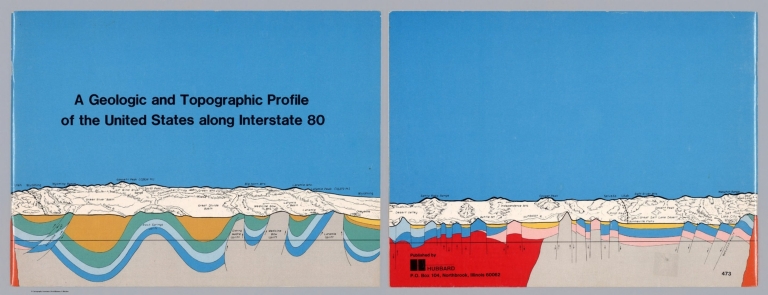
Full Title
(Covers to) A geologic and topographic profile of the United States along interstate 80 : by Chet Raymo. 1982. Printed by Hubbard, Northbrook, IL.
List No
13323.001
Note
Covers, with title and profile, covering the route along Interstate 80 from Santa Rosa range to Wyoming
Author
Raymo, Chet
Full Title
(Title Page to) A geologic and topographic profile of the United States along interstate 80 : by Chet Raymo. 1982. Printed by Hubbard, Northbrook, IL.
List No
13323.002
Note
Title page includes a map of the United States, showing the route form San Francisco to New York City along Interstate 80.
Author
Raymo, Chet
Full Title
(Text Page to) A geologic and topographic profile of the United States along interstate 80 : by Chet Raymo. 1982. Printed by Hubbard, Northbrook, IL.
List No
13323.005
Note
Color coded geologic key and Scale book in feet.
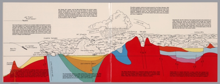
Author
Raymo, Chet
Full Title
(California, Nevada). (to accompany) A geologic and topographic profile of the United States along interstate 80 : by Chet Raymo. 1982. Printed by Hubbard, Northbrook, IL.
List No
13323.006
Note
Geologic cross section and map. Covers the area from Pacific Ocean and San Francisco to Carson Sink, showing the volcanic peaks, fault zone, weather system, lakes, drainage, cities and mountains. Includes descriptive text.
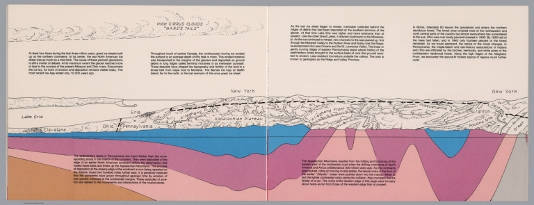
Author
Raymo, Chet
Full Title
(New York). (to accompany) A geologic and topographic profile of the United States along interstate 80 : by Chet Raymo. 1982. Printed by Hubbard, Northbrook, IL.
List No
13323.012
Note
Geologic cross section and topographic map. Covers from Cleveland, Ohio to Delaware. Showing weather system, dunes, ridges and major cities. Includes descriptive text.
Author
Raymo, Chet
Full Title
(Composite). A geologic and topographic profile of the United States along interstate 80 : by Chet Raymo. 1982. Printed by Hubbard, Northbrook, IL.
List No
13323.014
Note
Composite of 8 sheets of geologic cross section and topographic map. Covers the route along Interstate 80 from San Francisco to New York City.
Author
Raymo, Chet
Full Title
Crust of the Earth. (to accompany). A geologic and topographic profile of the United States along interstate 80 : by Chet Raymo. 1982. Printed by Hubbard, Northbrook, IL.
List No
13323.015
Note
Color cross section of the earth's crust from Pacific to Atlantic Oceans,
Author
Raymo, Chet
Full Title
Plate movement of the Earth's crust. (to accompany). A geologic and topographic profile of the United States along interstate 80 : by Chet Raymo. 1982. Printed by Hubbard, Northbrook, IL.
List No
13323.016
Note
Color cross section, showing the movement of the plates creates three types of tectonic boundaries, divergent, convergent, and lateral motion.
Author
[Ordnance Survey Office, Geikie, Archibald]
Full Title
(Composite of) Sheets 2 - 15. Ordnance Survey of England and Wales.
List No
8742.017
Author
[Geological Survey of Great Britain and Ireland, Great Britain, Ordnance Survey Office]
Full Title
44. Cheltenham.
List No
6913.076
Note
Paper.
Author
[U.S. Geological Survey, Alpha, Tau Rho]
Full Title
Central San Francisco Bay.
List No
6353.071
Author
[U.S. Geological Survey, Alpha, Tau Rho]
Full Title
Southern California Borderland.
List No
6353.087
Author
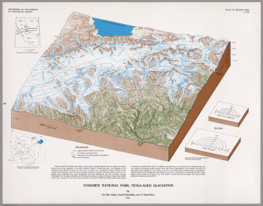
[U.S. Geological Survey, Alpha, Tau Rho, Huber, N. King, Wahrhaftig, Clyde]
Full Title
Yosemite National Park, Tioga-Aged Glaciation.
List No
6353.093
Author
King, Clarence
Full Title
(Covers to) Engineer Department U.S.A. Geological and Topographical Atlas Accompanying the Report of the Geological Exploration of the Fortieth Parallel Made by the Authority of the Honorable Secretary of War under the direction of Brig. and Brvt. Major General A.A. Humphreys, Chief of Engineers U.S.A. by Clarence King, U.S. Geologist in Charge, 1876. Julius Bien Lith.
List No
0408A
Author
King, Clarence
Full Title
(Title Page to) Engineer Department U.S.A. Geological and Topographical Atlas Accompanying the Report of the Geological Exploration of the Fortieth Parallel Made by the Authority of the Honorable Secretary of War under the direction of Brig. and Brvt. Major General A.A. Humphreys, Chief of Engineers U.S.A. by Clarence King, U.S. Geologist in Charge, 1876. Julius Bien Lith.
List No
0408B
Note
Magnificent, huge atlas showing the area of the 40th Parallel Survey in topographical and geological maps. Wheat notes: "These are pioneer survey maps, and as such are most interesting. Mapping the West in so broad a cross-section had never before been attempted, a portent of things to come." King, at the age of 25, was made Geologist-in-charge of the Survey in 1867. He was formally ordered "to examine and describe the geological structure, geographical condition and natural resources of a belt of country extending from the 120th meridian eastward to the 105th meridian, along the 40th parallel of latitude with sufficient expansion north and south to include the lines of 'Central' and 'Union Pacific' railroads..." (Wheat). The topographical sheets depict features by brush shading rather than hachuring. In original binding -rare. Bound in green half leather with a label on the front, "Geological and Topographical Atlas Accompanying the Report of the Geological Exploration of the Fortieth Parallel. Clarence King, Geologist in Charge."
Author
King, Clarence
Full Title
(Index Page to) Engineer Department U.S.A. Geological and Topographical Atlas Accompanying the Report of the Geological Exploration of the Fortieth Parallel Made by the Authority of the Honorable Secretary of War under the direction of Brig. and Brvt. Major General A.A. Humphreys, Chief of Engineers U.S.A. by Clarence King, U.S. Geologist in Charge, 1876. Julius Bien Lith.
List No
0408C
Note
Index page includes the list of maps and a legend naming the mapmakers and the basis by which the maps were made.
Author
King, Clarence
Full Title
Cordilleras.
List No
0408.001
Note
Map in what came to be known as "plastic shading." The development of halftone lithography made this technique possible. The technique depicts surface features by brush shading rather than the more conventional hachuring. The map is in brown tones with the index maps highlighted in red.
Author
King, Clarence
Full Title
Rocky Mountains. Map I. (Geological)
List No
0408.002
Note
Map in full color with the legends on either side of the maps. Map extends from Cheyenne in the east to Fortification Peak in the west (Wyoming). Below the map are two geologic cross sections.
Author
King, Clarence
Full Title
Green River Basin. Map II. (Geological)
List No
0408.003
Note
Map in full color with the legends on either side of the maps. Map extends from Fortification Peak in Wyoming to Piedmont in Utah. Below the map are two geologic cross sections.
Author
King, Clarence
Full Title
Utah Basin. Map III. (Geological)
List No
0408.004
Note
Map in full color with the legends on either side of the maps. Map extends from Piedmont in Utah to Bovine, Utah including the Great Salt Lake. Below the map are two geologic cross sections.
Author
King, Clarence
Full Title
Nevada Plateau. Map IV. (Geological)
List No
0408.005
Note
Map in full color with the legends on either side of the maps. Map extends from Bovine, Utah across the Nevada plateau to Argenta, Nevada. Below the map are two geologic cross sections.
Author
King, Clarence
Full Title
Nevada Basin. Map V. (Geological)
List No
0408.006
Note
Map in full color with the legends on either side of the maps. Map extends from Argenta, Nevada to the west of Pyramid Lake (Lake Tahoe) in California. Below the map are two geologic cross sections.
Author
King, Clarence
Full Title
(Composite of) Geological Maps I-V, 40th Parallel Survey.
List No
0408.007
Note
Maps in full color with the legends on either side of the maps.
Author
King, Clarence
Full Title
General Sections.
List No
0408.008
Note
In full color. Ten sections shown with the legends on either side of the cross sections.
Author
Spurr, Josiah Edward
Full Title
(Covers to) Department Of The Interior, United States Geological Survey, Charles D. Walcott, Director. Atlas To Accompany Monograph XXXI On The Geology Of The Aspen District Colorado By Josiah Edward Spurr, Samuel Franklin Emmons, Geologist In Charge. Washington 1898. Julius Bien & Co. Lith. N.Y.
List No
0942A
Note
Bound in original dark brown cloth covered boards with "United States Geological Survey, Charles D. Walcott, Director. Atlas To Accompany Monograph XXXI On The Geology Of The Aspen District Colorado. Josiah Edward Spurr" stamped in gilt.
Author
Spurr, Josiah Edward
Full Title
(Title Page to) Department Of The Interior, United States Geological Survey, Charles D. Walcott, Director. Atlas To Accompany Monograph XXXI On The Geology Of The Aspen District Colorado By Josiah Edward Spurr, Samuel Franklin Emmons, Geologist In Charge. Washington 1898. Julius Bien & Co. Lith. N.Y.
List No
0942B
Author
Spurr, Josiah Edward
Full Title
(Table of Contents to) Department Of The Interior, United States Geological Survey, Charles D. Walcott, Director. Atlas To Accompany Monograph XXXI On The Geology Of The Aspen District Colorado By Josiah Edward Spurr, Samuel Franklin Emmons, Geologist In Charge. Washington 1898. Julius Bien & Co. Lith. N.Y.
List No
0942C
Author
Spurr, Josiah Edward
Full Title
(Legend to) Department Of The Interior, United States Geological Survey, Charles D. Walcott, Director. Atlas To Accompany Monograph XXXI On The Geology Of The Aspen District Colorado By Josiah Edward Spurr, Samuel Franklin Emmons, Geologist In Charge. Washington 1898. Julius Bien & Co. Lith. N.Y.
List No
0942D
Note
Provides a description of the atlas and geology of the Aspen Mining District, Colorado.
Author
Spurr, Josiah Edward
Full Title
Aspen District Sheet. Geology Sheet VI . U. S. Geological Survey, Charles D. Walcott, Director. Monograph XXXI. A.H. Thompson, Geographer. Morris Bien, Topographer in charge. Triangulation by Morris Bien. Topography by F.F. Grove. Surveyed in 1891. S.F. Emmons, Geologist in charge. Geology by J.E. Spurr. Assistant, G.W. Tower. Julius Bien & Co. Lith. N.Y. (1898)
List No
0942.003
Note
Topography shown by 100-foot contours. Shows streams, mines, roads, trails, and settlements. Geology shown in 16 colored classes, and faults. Shows alignment of cross-sections presented on the subsequent sheet.
Author
Spurr, Josiah Edward
Full Title
Sheet VII Sections. U. S. Geological Survey, Charles D. Walcott, Director. Monograph XXXI. Julius Bien & Co. Lith. N.Y. (1898)
List No
0942.004
Note
Geology shown in 16 colored classes, and faults.
Author
Spurr, Josiah Edward
Full Title
Aspen Special Sheet. Geology Sheet IX. U. S. Geological Survey, Charles D. Walcott, Director. Monograph XXXI. A.H. Thompson, Geographer. Morris Bien, Topographer in charge. Triangulation by Morris Bien. Topography by F.F. Grove. Surveyed in 1891. S.F. Emmons, Geologist in charge. Geology by J.E. Spurr. Assistant, G.W. Tower. Julius Bien & Co. Lith. N.Y. (1898)
List No
0942.006
Note
Geology shown in color in 11 classes, and faults. Cross section alignments provided in next sheet shown here.
Author
Spurr, Josiah Edward
Full Title
Aspen Special Sheet. Sheet X Sections. U. S. Geological Survey, Charles D. Walcott, Director. Monograph XXXI. Julius Bien & Co. Lith. N.Y. (1898)
List No
0942.007
Note
Geologic cross-sections shown in color in 11 classes, and faults.
Author
Spurr, Josiah Edward
Full Title
Tourtelotte Park Special. Geology Sheet XII. U. S. Geological Survey, Charles D. Walcott, Director. Monograph XXXI. A.H. Thompson, Geographer. Morris Bien, Topographer in charge. Triangulation by Morris Bien. Topography by F.F. Grove. Surveyed in 1891. S.F. Emmons, Geologist in charge. Geology by J.E. Spurr. Assistant, G.W. Tower. Julius Bien & Co. Lith. N.Y. (1898)
List No
0942.009
Note
Geology shown in color with 10 classes of rock, and faults. Shows alignment of cross-sections on following sheets.
Author
Spurr, Josiah Edward
Full Title
Tourtelotte Park Special Sheet. Sheet XIII Sections. U. S. Geological Survey, Charles D. Walcott, Director. Monograph XXXI. Julius Bien & Co. Lith. N.Y. (1898)
List No
0942.010
Note
Geologic cross-sections shown in color in 9 classes, and faults.
Author
Spurr, Josiah Edward
Full Title
Tourtelotte Park Special Sheet. Sheet XIV Sections. U. S. Geological Survey, Charles D. Walcott, Director. Monograph XXXI. Julius Bien & Co. Lith. N.Y. (1898)
List No
0942.011
Note
Geologic cross-sections shown in color in 9 classes, and faults.
Author
Spurr, Josiah Edward
Full Title
Tourtelotte Park Special Sheet. Sheet XV Sections. U. S. Geological Survey, Charles D. Walcott, Director. Monograph XXXI. Julius Bien & Co. Lith. N.Y. (1898)
List No
0942.012
Note
Geologic cross-sections shown in color in 9 classes, and faults.
Author
Spurr, Josiah Edward
Full Title
Hunter Park Special Sheet. Geology Sheet XVII . U. S. Geological Survey, Charles D. Walcott, Director. Monograph XXXI. A.H. Thompson, Geographer. F.M Douglas, Topographer in charge. Triangulation by E.M. Douglas. Topography by (R.C. McKinney). S.F. Emmons, Geologist in Charge. Geology by J.E. Spurr. Assistant, G.W. Tower. Surveyed in 1893. Julius Bien & Co. Lith. N.Y. (1898)
List No
0942.014
Note
Geology shown in color in 8 classes of rock, and faults. Alignment of cross-sections on next sheet shown.
Author
Spurr, Josiah Edward
Full Title
Hunter Park Special Sheet. Sheet XVIII Sections. U. S. Geological Survey, Charles D. Walcott, Director. Monograph XXXI. Julius Bien & Co. Lith. N.Y. (1898)
List No
0942.015
Note
Geologic cross-sections shown in color in 8 classes, and faults.
Author
Spurr, Josiah Edward
Full Title
Lenado Special Sheet. Geology Sheet XX . U. S. Geological Survey, Charles D. Walcott, Director. Monograph XXXI. A.H. Thompson, Geographer. F.M Douglas, Topographer in charge. Triangulation by E.M. Douglas. Topography by W.B. Gorse and R.H. Chapman. Surveyed in 1893. S.F. Emmons, Geologist in Charge. Geology by J.E. Spurr. Assistant, G.W. Tower. Julius Bien & Co. Lith. N.Y. (1898)
List No
0942.017
Note
Geology shown in color in 8 classes of rock, and faults. Map and cross sections on one sheet.
Author
Spurr, Josiah Edward
Full Title
Tourtelotte Park Mining District Sheet. Geology Sheet XXI. U. S. Geological Survey, Charles D. Walcott, Director. Monograph XXXI. A.H. Thompson, Geographer. Morris Bien, Topographer in charge. Triangulation by Morris Bien. Topography by F.F. Grove. Surveyed in 1891. S.F. Emmons, Geologist in charge. Geology by J.E. Spurr. Assistant, G.W. Tower. Julius Bien & Co. Lith. N.Y. (1898)
List No
0942.018
Note
Geology shown in color with 10 classes of rock, and faults. Shows alignment of cross-sections on following sheets.
Author
Spurr, Josiah Edward
Full Title
Tourtelotte Park Mining District Sheet. Sheet XXII Sections. U. S. Geological Survey, Charles D. Walcott, Director. Monograph XXXI. Julius Bien & Co. Lith. N.Y. (1898)
List No
0942.019
Note
Geologic cross-sections shown in color in 9 classes, and faults.
Author
Spurr, Josiah Edward
Full Title
Tourtelotte Park Mining District Sheet. Sheet XXIII Sections. U. S. Geological Survey, Charles D. Walcott, Director. Monograph XXXI. Julius Bien & Co. Lith. N.Y. (1898)
List No
0942.020
Note
Geologic cross-sections shown in color in 9 classes, and faults.
Author
Spurr, Josiah Edward
Full Title
Tourtelotte Park Mining District Sheet. Sheet XXIV Sections. U. S. Geological Survey, Charles D. Walcott, Director. Monograph XXXI. Julius Bien & Co. Lith. N.Y. (1898)
List No
0942.021
Note
Geologic cross-sections shown in color in 9 classes, and faults.
Author
Spurr, Josiah Edward
Full Title
Aspen Mountain Sheet. Geology Sheet XXV. U. S. Geological Survey, Charles D. Walcott, Director. Monograph XXXI. A.H. Thompson, Geographer. Morris Bien, Topographer in charge. Triangulation by Morris Bien. Topography by F.F. Grove. Surveyed in 1891. S.F. Emmons, Geologist in charge. Geology by J.E. Spurr. Assistant, G.W. Tower. Julius Bien & Co. Lith. N.Y. (1898)
List No
0942.022
Note
Geology shown in color with 10 classes of rock, and faults. Shows alignment of cross-sections on following sheet.
Author
Spurr, Josiah Edward
Full Title
Aspen Mountain Sheet. Sheet XXVI Sections. U. S. Geological Survey, Charles D. Walcott, Director. Monograph XXXI. Julius Bien & Co. Lith. N.Y. (1898)
List No
0942.023
Note
Geologic cross-sections shown in color in 10 classes, and faults.
Author
Spurr, Josiah Edward
Full Title
Smuggler Mountain. Geology Sheet XXVII. U. S. Geological Survey, Charles D. Walcott, Director. Monograph XXXI. A.H. Thompson, Geographer. Morris Bien, Topographer in charge. Triangulation by Morris Bien. Topography by F.F. Grove. Surveyed in 1891. S.F. Emmons, Geologist in charge. Geology by J.E. Spurr. Assistant, G.W. Tower. Julius Bien & Co. Lith. N.Y. (1898)
List No
0942.024
Note
Geology shown in color with 9 classes of rock, and faults. Shows alignment of cross-sections on following sheets.
Author
Spurr, Josiah Edward
Full Title
Smuggler Mountain Sheet. Sheet XXVIII Sections. U. S. Geological Survey, Charles D. Walcott, Director. Monograph XXXI. Julius Bien & Co. Lith. N.Y. (1898)
List No
0942.025
Note
Geologic cross-sections shown in color in 9 classes, and faults.
Author
Spurr, Josiah Edward
Full Title
Smuggler Mountain Sheet. Sheet XXIX Sections. U. S. Geological Survey, Charles D. Walcott, Director. Monograph XXXI. Julius Bien & Co. Lith. N.Y. (1898)
List No
0942.026
Note
Geologic cross-sections shown in color in 9 classes, and faults.
Author
Spurr, Josiah Edward
Full Title
Lenado Mining District Sheet. Sheet XXX Sections. U. S. Geological Survey, Charles D. Walcott, Director. Monograph XXXI. Julius Bien & Co. Lith. N.Y. (1898)
List No
0942.027
Note
Geologic map and cross-sections shown in color in 7 classes, and faults.
Author
[Bayley, W.S., Smyth, H. L., Van Hise, C.]
Full Title
General Geological Map of the Marquette District. By C.R. Van Hise and W.S. Bayley. Julius Bien & Co. Lith. N.Y.
List No
1111.001
Note
Includes colored geologic map with 19 rock types, faults, and numerous cross sections. Contour interval 50 feet. Fold-out sheet.
Author
[Bayley, W.S., Smyth, H. L., Van Hise, C.]
Full Title
Detailed Geology Sheet V. (T 48 N, R 30 W, SW Quarter). Julius Bien & Co. Lith. N.Y.
List No
1111.002
Note
Relief shown by 20-foot contours. Colored geologic map shows railroads, roads, trails, settlements, swamps, streams, lakes, rock types, and outcrops. Geologic cross sections included.
Author
[Bayley, W.S., Smyth, H. L., Van Hise, C.]
Full Title
Detailed Geology Sheet VI. (T 47 N, R 30 W, NW Quarter). Julius Bien & Co. Lith. N.Y.
List No
1111.003
Note
Relief shown by 20-foot contours. Colored geologic map shows railroads, roads, trails, settlements, swamps, streams, lakes, rock types, and outcrops. Geologic cross sections included.
Author
[Bayley, W.S., Smyth, H. L., Van Hise, C.]
Full Title
Detailed Geology Sheet VII. (T 47 N, R 30 W, SW Quarter). Julius Bien & Co. Lith. N.Y.
List No
1111.004
Note
Relief shown by 20-foot contours. Colored geologic map shows railroads, roads, trails, settlements, swamps, streams, lakes, rock types, and outcrops. Geologic cross sections included.
Author
[Bayley, W.S., Smyth, H. L., Van Hise, C.]
Full Title
Detailed Geology Sheet VIII. (T 48 N, R 30 W, SE Quarter). Julius Bien & Co. Lith. N.Y.
List No
1111.005
Note
Relief shown by 20-foot contours. Colored geologic map shows railroads, roads, trails, settlements, swamps, streams, lakes, rock types, and outcrops. Geologic cross sections included.
Author
[Bayley, W.S., Smyth, H. L., Van Hise, C.]
Full Title
Detailed Geology Sheet IX. (T 47 N, R 30 W, NE Quarter). Julius Bien & Co. Lith. N.Y.
List No
1111.006
Note
Relief shown by 20-foot contours. Colored geologic map shows railroads, roads, trails, settlements, swamps, streams, lakes, rock types, and outcrops. Geologic cross sections included.
Author
[Bayley, W.S., Smyth, H. L., Van Hise, C.]
Full Title
Detailed Geology Sheet X. (T 47 N, R 30 W, SE Quarter). Julius Bien & Co. Lith. N.Y.
List No
1111.007
Note
Relief shown by 20-foot contours. Colored geologic map shows railroads, roads, trails, settlements, swamps, streams, lakes, rock types, and outcrops. Geologic cross sections included.
Author
[Bayley, W.S., Smyth, H. L., Van Hise, C.]
Full Title
Detailed Geology Sheet XI. (T 46 N, R 29 and 30 W, southern part of the Republic Trough). Julius Bien & Co. Lith. N.Y.
List No
1111.008
Note
Relief shown by 20-foot contours. Colored geologic map shows railroads, roads, trails, settlements, swamps, streams, lakes, rock types, and outcrops. Geologic cross sections included.
Author
[Bayley, W.S., Smyth, H. L., Van Hise, C.]
Full Title
Detailed Geology Sheet XII. (T 48 N, R 29 W, SW Quarter). Julius Bien & Co. Lith. N.Y.
List No
1111.009
Note
Relief shown by 20-foot contours. Colored geologic map shows railroads, roads, trails, settlements, swamps, streams, lakes, rock types, and outcrops. Geologic cross sections included.
Author
[Bayley, W.S., Smyth, H. L., Van Hise, C.]
Full Title
Detailed Geology Sheet XIII. (T 47 N, R 29 W, NW Quarter). Julius Bien & Co. Lith. N.Y.
List No
1111.010
Note
Relief shown by 20-foot contours. Colored geologic map shows railroads, roads, trails, settlements, swamps, streams, lakes, rock types, and outcrops. Geologic cross sections included.
Author
[Bayley, W.S., Smyth, H. L., Van Hise, C.]
Full Title
Detailed Geology Sheet XIV. (T 47 N, R 29 W, SW Quarter). Julius Bien & Co. Lith. N.Y.
List No
1111.011
Note
Relief shown by 20-foot contours. Colored geologic map shows railroads, roads, trails, settlements, swamps, streams, lakes, rock types, and outcrops. Geologic cross sections included.
Author
[Bayley, W.S., Smyth, H. L., Van Hise, C.]
Full Title
Detailed Geology Sheet XV. (T 48 N, R 29 W, SE Quarter). Julius Bien & Co. Lith. N.Y.
List No
1111.012
Note
Relief shown by 20-foot contours. Colored geologic map shows railroads, roads, trails, settlements, swamps, streams, lakes, rock types, and outcrops. Geologic cross sections included.
Author
[Bayley, W.S., Smyth, H. L., Van Hise, C.]
Full Title
Detailed Geology Sheet XVI. (T 47 N, R 29 W, NE Quarter). Julius Bien & Co. Lith. N.Y.
List No
1111.013
Note
Relief shown by 20-foot contours. Colored geologic map shows railroads, roads, trails, settlements, swamps, streams, lakes, rock types, and outcrops. Geologic cross sections included.
Author
[Bayley, W.S., Smyth, H. L., Van Hise, C.]
Full Title
Detailed Geology Sheet XVII. (T 47 N, R 29 W, SE Quarter). Julius Bien & Co. Lith. N.Y.
List No
1111.014
Note
Relief shown by 20-foot contours. Colored geologic map shows railroads, roads, trails, settlements, swamps, streams, lakes, rock types, and outcrops. Geologic cross sections included.
Author
[Bayley, W.S., Smyth, H. L., Van Hise, C.]
Full Title
Detailed Geology Sheet XVIII. (T 48 N, R 28 W, SW Quarter). Julius Bien & Co. Lith. N.Y.
List No
1111.015
Note
Relief shown by 20-foot contours. Colored geologic map shows railroads, roads, trails, settlements, swamps, streams, lakes, rock types, and outcrops. Geologic cross sections included.
Author
[Bayley, W.S., Smyth, H. L., Van Hise, C.]
Full Title
Detailed Geology Sheet XIX. (T 47 N, R 28 W, NW Quarter). Julius Bien & Co. Lith. N.Y.
List No
1111.016
Note
Relief shown by 20-foot contours. Colored geologic map shows railroads, roads, trails, settlements, swamps, streams, lakes, rock types, and outcrops. Geologic cross sections included.
Author
[Bayley, W.S., Smyth, H. L., Van Hise, C.]
Full Title
Detailed Geology Sheet XX. (T 47 N, R 28 W, SW Quarter). Julius Bien & Co. Lith. N.Y.
List No
1111.017
Note
Relief shown by 20-foot contours. Colored geologic map shows railroads, roads, trails, settlements, swamps, streams, lakes, rock types, and outcrops. Geologic cross sections included.
Author
[Bayley, W.S., Smyth, H. L., Van Hise, C.]
Full Title
Detailed Geology Sheet XXI. (T 48 N, R 28 W, SE Quarter). Julius Bien & Co. Lith. N.Y.
List No
1111.018
Note
Relief shown by 20-foot contours. Colored geologic map shows railroads, roads, trails, settlements, swamps, streams, lakes, rock types, and outcrops. Geologic cross sections included.
Author
[Bayley, W.S., Smyth, H. L., Van Hise, C.]
Full Title
Detailed Geology Sheet XXII. (T 47 N, R 28 W, NE Quarter). Julius Bien & Co. Lith. N.Y.
List No
1111.019
Note
Relief shown by 20-foot contours. Colored geologic map shows railroads, roads, trails, settlements, swamps, streams, lakes, rock types, and outcrops. Geologic cross sections included.
Author
[Bayley, W.S., Smyth, H. L., Van Hise, C.]
Full Title
Detailed Geology Sheet XXIII. (T 47 N, R 28 W, SE Quarter). Julius Bien & Co. Lith. N.Y.
List No
1111.020
Note
Relief shown by 20-foot contours. Colored geologic map shows railroads, roads, trails, settlements, swamps, streams, lakes, rock types, and outcrops. Geologic cross sections included.
Author
[Bayley, W.S., Smyth, H. L., Van Hise, C.]
Full Title
Detailed Geology Sheet XXIV. (T 48 N, R 27 W, SW Quarter). Julius Bien & Co. Lith. N.Y.
List No
1111.021
Note
Relief shown by 20-foot contours. Colored geologic map shows railroads, roads, trails, settlements, swamps, streams, lakes, rock types, and outcrops. Geologic cross sections included.
Author
[Bayley, W.S., Smyth, H. L., Van Hise, C.]
Full Title
Detailed Geology Sheet XXV. (T 47 N, R 27 W), NW Quarter. Julius Bien & Co. Lith. N.Y.
List No
1111.022
Note
Relief shown by 20-foot contours. Colored geologic map shows railroads, roads, trails, settlements, swamps, streams, lakes, rock types, and outcrops. Geologic cross sections included.
Author
[Bayley, W.S., Smyth, H. L., Van Hise, C.]
Full Title
Detailed Geology Sheet XXVI. (T 47 N, R 27 W, SW Quarter). Julius Bien & Co. Lith. N.Y.
List No
1111.023
Note
Relief shown by 20-foot contours. Colored geologic map shows railroads, roads, trails, settlements, swamps, streams, lakes, rock types, and outcrops. Geologic cross sections included.
Author
[Bayley, W.S., Smyth, H. L., Van Hise, C.]
Full Title
Detailed Geology Sheet XXVII. (T 48 N, R 27 W, SE Quarter). Julius Bien & Co. Lith. N.Y.
List No
1111.024
Note
Relief shown by 20-foot contours. Colored geologic map shows railroads, roads, trails, settlements, swamps, streams, lakes, rock types, and outcrops. Geologic cross sections included.
Author
[Bayley, W.S., Smyth, H. L., Van Hise, C.]
Full Title
Detailed Geology Sheet XXVIII. (T 47 N, R 27 W, NE Quarter). Julius Bien & Co. Lith. N.Y.
List No
1111.025
Note
Relief shown by 20-foot contours. Colored geologic map shows railroads, roads, trails, settlements, swamps, streams, lakes, rock types, and outcrops. Geologic cross sections included.
Author
[Bayley, W.S., Smyth, H. L., Van Hise, C.]
Full Title
Detailed Geology Sheet XXIX. (T 47 N, R 27 W, SE Quarter). Julius Bien & Co. Lith. N.Y.
List No
1111.026
Note
Relief shown by 20-foot contours. Colored geologic map shows railroads, roads, trails, settlements, swamps, streams, lakes, rock types, and outcrops. Geologic cross sections included.
Author
[Bayley, W.S., Smyth, H. L., Van Hise, C.]
Full Title
Detailed Geology Sheet XXX. (T 48 N, R 26 W, SW Quarter). Julius Bien & Co. Lith. N.Y.
List No
1111.027
Note
Relief shown by 20-foot contours. Colored geologic map shows railroads, roads, trails, settlements, swamps, streams, lakes, rock types, and outcrops. Geologic cross sections included.
Author
[Bayley, W.S., Smyth, H. L., Van Hise, C.]
Full Title
Detailed Geology Sheet XXXI. (T 47 N, R 26 W), NW Quarter. Julius Bien & Co. Lith. N.Y.
List No
1111.028
Note
Relief shown by 20-foot contours. Colored geologic map shows railroads, roads, trails, settlements, swamps, streams, lakes, rock types, and outcrops. Geologic cross sections included.
Author
[Bayley, W.S., Smyth, H. L., Van Hise, C.]
Full Title
Detailed Geology Sheet XXXII. (T 47 N, R 26 W, SW Quarter). Julius Bien & Co. Lith. N.Y.
List No
1111.029
Note
Relief shown by 20-foot contours. Colored geologic map shows railroads, roads, trails, settlements, swamps, streams, lakes, rock types, and outcrops. Geologic cross sections included.
Author
[Bayley, W.S., Smyth, H. L., Van Hise, C.]
Full Title
Detailed Geology Sheet XXXIII. (T 48 N, R 26 W, SE Quarter). Julius Bien & Co. Lith. N.Y.
List No
1111.030
Note
Relief shown by 20-foot contours. Colored geologic map shows railroads, roads, trails, settlements, swamps, streams, lakes, rock types, and outcrops. Geologic cross sections included.
Author
[Bayley, W.S., Smyth, H. L., Van Hise, C.]
Full Title
Detailed Geology Sheet XXXIV. (T 47 N, R 26 W, NE Quarter). Julius Bien & Co. Lith. N.Y.
List No
1111.031
Note
Relief shown by 20-foot contours. Colored geologic map shows railroads, roads, trails, settlements, swamps, streams, lakes, rock types, and outcrops. Geologic cross sections included.
Author
[Bayley, W.S., Smyth, H. L., Van Hise, C.]
Full Title
Detailed Geology Sheet XXXV. (T 47 N, R 26 W, SE Quarter). Julius Bien & Co. Lith. N.Y.
List No
1111.032
Note
Relief shown by 20-foot contours. Colored geologic map shows railroads, roads, trails, settlements, swamps, streams, lakes, rock types, and outcrops. Geologic cross sections included.
Author
[Bayley, W.S., Smyth, H. L., Van Hise, C.]
Full Title
Detailed Geology Sheet XXXVI. (T 48 N, R 25 W, SW Quarter). Julius Bien & Co. Lith. N.Y.
List No
1111.033
Note
Relief shown by 20-foot contours. Colored geologic map shows railroads, roads, trails, settlements, swamps, streams, lakes, rock types, and outcrops. Geologic cross sections included.
Author
[Bayley, W.S., Smyth, H. L., Van Hise, C.]
Full Title
Detailed Geology Sheet XXXVII. (T 47 N, R 25 W, NW Quarter). Julius Bien & Co. Lith. N.Y.
List No
1111.034
Note
Relief shown by 20-foot contours. Colored geologic map shows railroads, roads, trails, settlements, swamps, streams, lakes, rock types, and outcrops. Geologic cross sections included.
Author
[Bayley, W.S., Smyth, H. L., Van Hise, C.]
Full Title
Detailed Geology Sheet XXXVIII. (T 48 N, R 25 W, SE Quarter). Julius Bien & Co. Lith. N.Y.
List No
1111.035
Note
Relief shown by 20-foot contours. Colored geologic map shows railroads, roads, trails, settlements, swamps, streams, lakes, rock types, and outcrops. Geologic cross sections included.
Author
[Bayley, W.S., Smyth, H. L., Van Hise, C.]
Full Title
Detailed Geology Sheet XXXIX. (T 47 N, R 25 W, NE Quarter). Julius Bien & Co. Lith. N.Y.
List No
1111.036
Note
Relief shown by 20-foot contours. Colored geologic map shows railroads, roads, trails, settlements, swamps, streams, lakes, rock types, and outcrops. Geologic cross sections included.
Author
Raymo, Chet
Full Title
(Text Page to) A geologic and topographic profile of the United States along interstate 80 : by Chet Raymo. 1982. Printed by Hubbard, Northbrook, IL.
List No
13323.003
Author
Raymo, Chet
Full Title
(Text Page to) A geologic and topographic profile of the United States along interstate 80 : by Chet Raymo. 1982. Printed by Hubbard, Northbrook, IL.
List No
13323.004
Author
Raymo, Chet
Full Title
(Nevada, Utah). (to accompany) A geologic and topographic profile of the United States along interstate 80 : by Chet Raymo. 1982. Printed by Hubbard, Northbrook, IL.
List No
13323.007
Note
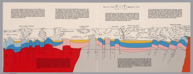
Geologic cross section and map. Covers the Great Basin between Sierra Nevada and the Rockies. Showing the earth's crust from the Carson Sink to the Great Salt Lake. Relief shown pictorially. Includes time zone clocks, showing Pacific standard time and Mountain standard time. Includes descriptive text.
Author
Raymo, Chet
Full Title
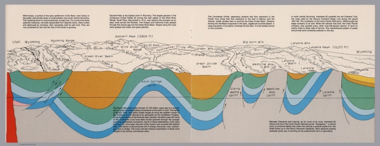
(Utah, Wayoming). (to accompany) A geologic and topographic profile of the United States along interstate 80 : by Chet Raymo. 1982. Printed by Hubbard, Northbrook, IL.
List No
13323.008
Note
Geologic cross section and map of Utah to Wyoming. Covers the area southwestern and south central Wyoming, showing the earth's crust, drainage and mountains. Relief shown pictorially and spot heights. "In the south central Wyoming, Interstate 80 parallels the Overland Trail". Includes descriptive text.
Author
Raymo, Chet
Full Title
(Great Plains, Nebraska). (to accompany) A geologic and topographic profile of the United States along interstate 80 : by Chet Raymo. 1982. Printed by Hubbard, Northbrook, IL.
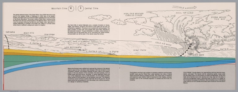
List No
13323.009
Note
Geologic cross section and topographic map of Great Plains, Nebraska. Showing weather system, dunes, ridges and vegetation. Relief shown pictorially. Includes time zone clocks, showing Mountain standard time and Central standard time. Includes descriptive text.
Author
Raymo, Chet
Full Title
(Nebraska, Iowa, Wisconsin). (to accompany) A geologic and topographic profile of the United States along interstate 80 : by Chet Raymo. 1982. Printed by Hubbard, Northbrook, IL.
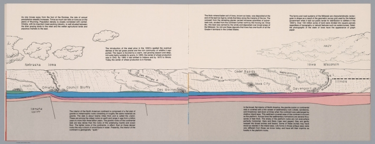
List No
13323.010
Note
Geologic cross section and topographic map. Covers Lincoln, Nebraska to Davenport, Iowa and part of Illinois . Showing weather system, dunes, ridges and major cities. Includes descriptive text.
Author
Raymo, Chet
Full Title
(Illinois, Michigan). (to accompany) A geologic and topographic profile of the United States along interstate 80 : by Chet Raymo. 1982. Printed by Hubbard, Northbrook, IL.
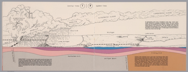
List No
13323.011
Note
Geologic cross section and topographic map. Covers Illinois and Michigan, part of Indiana and Ohio . Showing weather system, dunes, ridges and major cities. Includes time zone clocks, showing Central standard time and Eastern standard time. Includes descriptive text.
Author
Raymo, Chet
Full Title
(New York, Connecticut, Atlantic Ocean). (to accompany) A geologic and topographic profile of the United States along interstate 80 : by Chet Raymo. 1982. Printed by Hubbard, Northbrook, IL.
List No
13323.013
Note
Geologic cross section and topographic map. Covers from Catskill Mts, New York to Atlantic Ocean. Showing weather system, rivers, ridges and major cities. Relief shown by hachures. Includes descriptive text.
Author
Becker, George F.
Full Title
(Covers to) Department Of The Interior, United States Geological Survey, Clarence King Director. Atlas To Accompany The Monograph On The Geology Of The Comstock Lode And The Washoe District By George F. Becker. Washington 1882. Julius Bien & Co. Lith. New York.
List No
1566A
Author
Becker, George F.
Full Title
(Title Page to) Department Of The Interior, United States Geological Survey, Clarence King Director. Atlas To Accompany The Monograph On The Geology Of The Comstock Lode And The Washoe District By George F. Becker. Washington 1882. Julius Bien & Co. Lith. New York.
List No
1566B
Note
An important atlas of the mining activity in the Comstock Lode. With printed color. Bound in brown cloth covered boards with "United States Geological Survey, Clarence King, Director. Atlas To Accompany The Geology Of The Comstock Lode And The Washoe District. Becker" stamped in gilt.
|