|
Author
California Division of Mines and Geology
Full Title
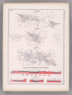
Geologic Map of California, Los Angeles Sheet.
List No
6347.037
Note
Full color. Olaf P. Jenkins Edition.
Author
California Division of Mines and Geology
Full Title
(Composite Map) Geologic Map of California.
List No
6347.114
Note
Full color. Olaf P. Jenkins Edition. Individual sheets dated 1958-1969.
Author
[Cuvier, Georges, Brongniart, Alexandre]
Full Title
(Coupe generale et ideale des divers terreins ou formations qui composent le sol des environs de Paris). (to accompany) Essai sur la geographie mineralogique des environs de Paris ... Par G. Cuvie. 1811.
List No
13382.005
Note
Folded cross sections, 38x74 on sheet 44x77. Showing the positions of all the grounds in vicinity of Paris.
Author
[Cuvier, Georges, Brongniart, Alexandre]
Full Title
Corps organises fossiles des couches marines des environs de Paris. Lecerf, Sculpt. (to accompany) Essai sur la geographie mineralogique des environs de Paris ... Par G. Cuvie. 1811.
List No
13382.006
Note
Folded plate, 25x19 on sheet 29x23. Showing fossil bodies from the sea layers in vicinity of Paris.
Author
[Cuvier, Georges, Brongniart, Alexandre]
Full Title
Carte geognostique des environs de Paris par MM. Cuvier et Brongniart 1810. Beuvelot fils delt. Cloquet sculp. (to accompany) Essai sur la geographie mineralogique des environs de Paris ... Par G. Cuvier. 1811.
List No
13382.007
Note
Folded color map on sheet 66x76 dissected and mounted on linen. Showing geologic formations. Includes legend showing various terrains and geologic formations.
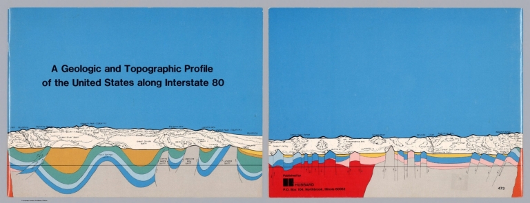
Author
Raymo, Chet
Full Title
(Covers to) A geologic and topographic profile of the United States along interstate 80 : by Chet Raymo. 1982. Printed by Hubbard, Northbrook, IL.
List No
13323.001
Note
Covers, with title and profile, covering the route along Interstate 80 from Santa Rosa range to Wyoming
Author
Raymo, Chet
Full Title
(Title Page to) A geologic and topographic profile of the United States along interstate 80 : by Chet Raymo. 1982. Printed by Hubbard, Northbrook, IL.
List No
13323.002
Note
Title page includes a map of the United States, showing the route form San Francisco to New York City along Interstate 80.
Author
Raymo, Chet
Full Title
(Text Page to) A geologic and topographic profile of the United States along interstate 80 : by Chet Raymo. 1982. Printed by Hubbard, Northbrook, IL.
List No
13323.005
Note
Color coded geologic key and Scale book in feet.
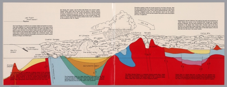
Author
Raymo, Chet
Full Title
(California, Nevada). (to accompany) A geologic and topographic profile of the United States along interstate 80 : by Chet Raymo. 1982. Printed by Hubbard, Northbrook, IL.
List No
13323.006
Note
Geologic cross section and map. Covers the area from Pacific Ocean and San Francisco to Carson Sink, showing the volcanic peaks, fault zone, weather system, lakes, drainage, cities and mountains. Includes descriptive text.
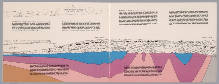
Author
Raymo, Chet
Full Title
(New York). (to accompany) A geologic and topographic profile of the United States along interstate 80 : by Chet Raymo. 1982. Printed by Hubbard, Northbrook, IL.
List No
13323.012
Note
Geologic cross section and topographic map. Covers from Cleveland, Ohio to Delaware. Showing weather system, dunes, ridges and major cities. Includes descriptive text.
Author
Raymo, Chet
Full Title
(Composite). A geologic and topographic profile of the United States along interstate 80 : by Chet Raymo. 1982. Printed by Hubbard, Northbrook, IL.
List No
13323.014
Note
Composite of 8 sheets of geologic cross section and topographic map. Covers the route along Interstate 80 from San Francisco to New York City.
Author
Raymo, Chet
Full Title
Crust of the Earth. (to accompany). A geologic and topographic profile of the United States along interstate 80 : by Chet Raymo. 1982. Printed by Hubbard, Northbrook, IL.
List No
13323.015
Note
Color cross section of the earth's crust from Pacific to Atlantic Oceans,
Author
Raymo, Chet
Full Title
Plate movement of the Earth's crust. (to accompany). A geologic and topographic profile of the United States along interstate 80 : by Chet Raymo. 1982. Printed by Hubbard, Northbrook, IL.
List No
13323.016
Note
Color cross section, showing the movement of the plates creates three types of tectonic boundaries, divergent, convergent, and lateral motion.
Author
[Ordnance Survey Office, Geikie, Archibald]
Full Title
(Composite of) Sheets 2 - 15. Ordnance Survey of England and Wales.
List No
8742.017
Author
[Geological Survey of Great Britain and Ireland, Great Britain, Ordnance Survey Office]
Full Title
44. Cheltenham.
List No
6913.076
Note
Paper.
Author
[U.S. Geological Survey, Alpha, Tau Rho]
Full Title
Central San Francisco Bay.
List No
6353.071
Author
[U.S. Geological Survey, Alpha, Tau Rho]
Full Title
Southern California Borderland.
List No
6353.087
Author
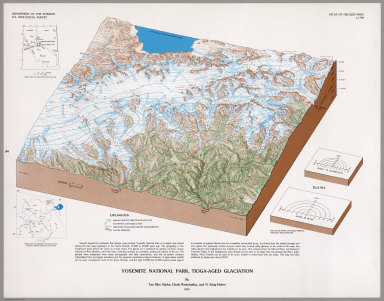
[U.S. Geological Survey, Alpha, Tau Rho, Huber, N. King, Wahrhaftig, Clyde]
Full Title
Yosemite National Park, Tioga-Aged Glaciation.
List No
6353.093
Author
King, Clarence
Full Title
(Covers to) Engineer Department U.S.A. Geological and Topographical Atlas Accompanying the Report of the Geological Exploration of the Fortieth Parallel Made by the Authority of the Honorable Secretary of War under the direction of Brig. and Brvt. Major General A.A. Humphreys, Chief of Engineers U.S.A. by Clarence King, U.S. Geologist in Charge, 1876. Julius Bien Lith.
List No
0408A
Author
King, Clarence
Full Title
(Title Page to) Engineer Department U.S.A. Geological and Topographical Atlas Accompanying the Report of the Geological Exploration of the Fortieth Parallel Made by the Authority of the Honorable Secretary of War under the direction of Brig. and Brvt. Major General A.A. Humphreys, Chief of Engineers U.S.A. by Clarence King, U.S. Geologist in Charge, 1876. Julius Bien Lith.
List No
0408B
Note
Magnificent, huge atlas showing the area of the 40th Parallel Survey in topographical and geological maps. Wheat notes: "These are pioneer survey maps, and as such are most interesting. Mapping the West in so broad a cross-section had never before been attempted, a portent of things to come." King, at the age of 25, was made Geologist-in-charge of the Survey in 1867. He was formally ordered "to examine and describe the geological structure, geographical condition and natural resources of a belt of country extending from the 120th meridian eastward to the 105th meridian, along the 40th parallel of latitude with sufficient expansion north and south to include the lines of 'Central' and 'Union Pacific' railroads..." (Wheat). The topographical sheets depict features by brush shading rather than hachuring. In original binding -rare. Bound in green half leather with a label on the front, "Geological and Topographical Atlas Accompanying the Report of the Geological Exploration of the Fortieth Parallel. Clarence King, Geologist in Charge."
Author
King, Clarence
Full Title
(Index Page to) Engineer Department U.S.A. Geological and Topographical Atlas Accompanying the Report of the Geological Exploration of the Fortieth Parallel Made by the Authority of the Honorable Secretary of War under the direction of Brig. and Brvt. Major General A.A. Humphreys, Chief of Engineers U.S.A. by Clarence King, U.S. Geologist in Charge, 1876. Julius Bien Lith.
List No
0408C
Note
Index page includes the list of maps and a legend naming the mapmakers and the basis by which the maps were made.
Author
King, Clarence
Full Title
Cordilleras.
List No
0408.001
Note
Map in what came to be known as "plastic shading." The development of halftone lithography made this technique possible. The technique depicts surface features by brush shading rather than the more conventional hachuring. The map is in brown tones with the index maps highlighted in red.
Author
King, Clarence
Full Title
Rocky Mountains. Map I. (Geological)
List No
0408.002
Note
Map in full color with the legends on either side of the maps. Map extends from Cheyenne in the east to Fortification Peak in the west (Wyoming). Below the map are two geologic cross sections.
Author
King, Clarence
Full Title
Green River Basin. Map II. (Geological)
List No
0408.003
Note
Map in full color with the legends on either side of the maps. Map extends from Fortification Peak in Wyoming to Piedmont in Utah. Below the map are two geologic cross sections.
Author
King, Clarence
Full Title
Utah Basin. Map III. (Geological)
List No
0408.004
Note
Map in full color with the legends on either side of the maps. Map extends from Piedmont in Utah to Bovine, Utah including the Great Salt Lake. Below the map are two geologic cross sections.
Author
King, Clarence
Full Title
Nevada Plateau. Map IV. (Geological)
List No
0408.005
Note
Map in full color with the legends on either side of the maps. Map extends from Bovine, Utah across the Nevada plateau to Argenta, Nevada. Below the map are two geologic cross sections.
Author
King, Clarence
Full Title
Nevada Basin. Map V. (Geological)
List No
0408.006
Note
Map in full color with the legends on either side of the maps. Map extends from Argenta, Nevada to the west of Pyramid Lake (Lake Tahoe) in California. Below the map are two geologic cross sections.
Author
King, Clarence
Full Title
(Composite of) Geological Maps I-V, 40th Parallel Survey.
List No
0408.007
Note
Maps in full color with the legends on either side of the maps.
Author
King, Clarence
Full Title
General Sections.
List No
0408.008
Note
In full color. Ten sections shown with the legends on either side of the cross sections.
Author
Spurr, Josiah Edward
Full Title
(Covers to) Department Of The Interior, United States Geological Survey, Charles D. Walcott, Director. Atlas To Accompany Monograph XXXI On The Geology Of The Aspen District Colorado By Josiah Edward Spurr, Samuel Franklin Emmons, Geologist In Charge. Washington 1898. Julius Bien & Co. Lith. N.Y.
List No
0942A
Note
Bound in original dark brown cloth covered boards with "United States Geological Survey, Charles D. Walcott, Director. Atlas To Accompany Monograph XXXI On The Geology Of The Aspen District Colorado. Josiah Edward Spurr" stamped in gilt.
Author
Spurr, Josiah Edward
Full Title
(Title Page to) Department Of The Interior, United States Geological Survey, Charles D. Walcott, Director. Atlas To Accompany Monograph XXXI On The Geology Of The Aspen District Colorado By Josiah Edward Spurr, Samuel Franklin Emmons, Geologist In Charge. Washington 1898. Julius Bien & Co. Lith. N.Y.
List No
0942B
Author
Spurr, Josiah Edward
Full Title
(Table of Contents to) Department Of The Interior, United States Geological Survey, Charles D. Walcott, Director. Atlas To Accompany Monograph XXXI On The Geology Of The Aspen District Colorado By Josiah Edward Spurr, Samuel Franklin Emmons, Geologist In Charge. Washington 1898. Julius Bien & Co. Lith. N.Y.
List No
0942C
Author
Spurr, Josiah Edward
Full Title
(Legend to) Department Of The Interior, United States Geological Survey, Charles D. Walcott, Director. Atlas To Accompany Monograph XXXI On The Geology Of The Aspen District Colorado By Josiah Edward Spurr, Samuel Franklin Emmons, Geologist In Charge. Washington 1898. Julius Bien & Co. Lith. N.Y.
List No
0942D
Note
Provides a description of the atlas and geology of the Aspen Mining District, Colorado.
Author
Spurr, Josiah Edward
Full Title
Aspen District Sheet. Geology Sheet VI . U. S. Geological Survey, Charles D. Walcott, Director. Monograph XXXI. A.H. Thompson, Geographer. Morris Bien, Topographer in charge. Triangulation by Morris Bien. Topography by F.F. Grove. Surveyed in 1891. S.F. Emmons, Geologist in charge. Geology by J.E. Spurr. Assistant, G.W. Tower. Julius Bien & Co. Lith. N.Y. (1898)
List No
0942.003
Note
Topography shown by 100-foot contours. Shows streams, mines, roads, trails, and settlements. Geology shown in 16 colored classes, and faults. Shows alignment of cross-sections presented on the subsequent sheet.
Author
Spurr, Josiah Edward
Full Title
Sheet VII Sections. U. S. Geological Survey, Charles D. Walcott, Director. Monograph XXXI. Julius Bien & Co. Lith. N.Y. (1898)
List No
0942.004
Note
Geology shown in 16 colored classes, and faults.
Author
Spurr, Josiah Edward
Full Title
Aspen Special Sheet. Geology Sheet IX. U. S. Geological Survey, Charles D. Walcott, Director. Monograph XXXI. A.H. Thompson, Geographer. Morris Bien, Topographer in charge. Triangulation by Morris Bien. Topography by F.F. Grove. Surveyed in 1891. S.F. Emmons, Geologist in charge. Geology by J.E. Spurr. Assistant, G.W. Tower. Julius Bien & Co. Lith. N.Y. (1898)
List No
0942.006
Note
Geology shown in color in 11 classes, and faults. Cross section alignments provided in next sheet shown here.
Author
Spurr, Josiah Edward
Full Title
Aspen Special Sheet. Sheet X Sections. U. S. Geological Survey, Charles D. Walcott, Director. Monograph XXXI. Julius Bien & Co. Lith. N.Y. (1898)
List No
0942.007
Note
Geologic cross-sections shown in color in 11 classes, and faults.
Author
Spurr, Josiah Edward
Full Title
Tourtelotte Park Special. Geology Sheet XII. U. S. Geological Survey, Charles D. Walcott, Director. Monograph XXXI. A.H. Thompson, Geographer. Morris Bien, Topographer in charge. Triangulation by Morris Bien. Topography by F.F. Grove. Surveyed in 1891. S.F. Emmons, Geologist in charge. Geology by J.E. Spurr. Assistant, G.W. Tower. Julius Bien & Co. Lith. N.Y. (1898)
List No
0942.009
Note
Geology shown in color with 10 classes of rock, and faults. Shows alignment of cross-sections on following sheets.
Author
Spurr, Josiah Edward
Full Title
Tourtelotte Park Special Sheet. Sheet XIII Sections. U. S. Geological Survey, Charles D. Walcott, Director. Monograph XXXI. Julius Bien & Co. Lith. N.Y. (1898)
List No
0942.010
Note
Geologic cross-sections shown in color in 9 classes, and faults.
Author
Spurr, Josiah Edward
Full Title
Tourtelotte Park Special Sheet. Sheet XIV Sections. U. S. Geological Survey, Charles D. Walcott, Director. Monograph XXXI. Julius Bien & Co. Lith. N.Y. (1898)
List No
0942.011
Note
Geologic cross-sections shown in color in 9 classes, and faults.
Author
Spurr, Josiah Edward
Full Title
Tourtelotte Park Special Sheet. Sheet XV Sections. U. S. Geological Survey, Charles D. Walcott, Director. Monograph XXXI. Julius Bien & Co. Lith. N.Y. (1898)
List No
0942.012
Note
Geologic cross-sections shown in color in 9 classes, and faults.
Author
Spurr, Josiah Edward
Full Title
Hunter Park Special Sheet. Geology Sheet XVII . U. S. Geological Survey, Charles D. Walcott, Director. Monograph XXXI. A.H. Thompson, Geographer. F.M Douglas, Topographer in charge. Triangulation by E.M. Douglas. Topography by (R.C. McKinney). S.F. Emmons, Geologist in Charge. Geology by J.E. Spurr. Assistant, G.W. Tower. Surveyed in 1893. Julius Bien & Co. Lith. N.Y. (1898)
List No
0942.014
Note
Geology shown in color in 8 classes of rock, and faults. Alignment of cross-sections on next sheet shown.
Author
Spurr, Josiah Edward
Full Title
Hunter Park Special Sheet. Sheet XVIII Sections. U. S. Geological Survey, Charles D. Walcott, Director. Monograph XXXI. Julius Bien & Co. Lith. N.Y. (1898)
List No
0942.015
Note
Geologic cross-sections shown in color in 8 classes, and faults.
Author
Spurr, Josiah Edward
Full Title
Lenado Special Sheet. Geology Sheet XX . U. S. Geological Survey, Charles D. Walcott, Director. Monograph XXXI. A.H. Thompson, Geographer. F.M Douglas, Topographer in charge. Triangulation by E.M. Douglas. Topography by W.B. Gorse and R.H. Chapman. Surveyed in 1893. S.F. Emmons, Geologist in Charge. Geology by J.E. Spurr. Assistant, G.W. Tower. Julius Bien & Co. Lith. N.Y. (1898)
List No
0942.017
Note
Geology shown in color in 8 classes of rock, and faults. Map and cross sections on one sheet.
Author
Spurr, Josiah Edward
Full Title
Tourtelotte Park Mining District Sheet. Geology Sheet XXI. U. S. Geological Survey, Charles D. Walcott, Director. Monograph XXXI. A.H. Thompson, Geographer. Morris Bien, Topographer in charge. Triangulation by Morris Bien. Topography by F.F. Grove. Surveyed in 1891. S.F. Emmons, Geologist in charge. Geology by J.E. Spurr. Assistant, G.W. Tower. Julius Bien & Co. Lith. N.Y. (1898)
List No
0942.018
Note
Geology shown in color with 10 classes of rock, and faults. Shows alignment of cross-sections on following sheets.
Author
Spurr, Josiah Edward
Full Title
Tourtelotte Park Mining District Sheet. Sheet XXII Sections. U. S. Geological Survey, Charles D. Walcott, Director. Monograph XXXI. Julius Bien & Co. Lith. N.Y. (1898)
List No
0942.019
Note
Geologic cross-sections shown in color in 9 classes, and faults.
Author
Spurr, Josiah Edward
Full Title
Tourtelotte Park Mining District Sheet. Sheet XXIII Sections. U. S. Geological Survey, Charles D. Walcott, Director. Monograph XXXI. Julius Bien & Co. Lith. N.Y. (1898)
List No
0942.020
Note
Geologic cross-sections shown in color in 9 classes, and faults.
Author
Spurr, Josiah Edward
Full Title
Tourtelotte Park Mining District Sheet. Sheet XXIV Sections. U. S. Geological Survey, Charles D. Walcott, Director. Monograph XXXI. Julius Bien & Co. Lith. N.Y. (1898)
List No
0942.021
Note
Geologic cross-sections shown in color in 9 classes, and faults.
Author
Spurr, Josiah Edward
Full Title
Aspen Mountain Sheet. Geology Sheet XXV. U. S. Geological Survey, Charles D. Walcott, Director. Monograph XXXI. A.H. Thompson, Geographer. Morris Bien, Topographer in charge. Triangulation by Morris Bien. Topography by F.F. Grove. Surveyed in 1891. S.F. Emmons, Geologist in charge. Geology by J.E. Spurr. Assistant, G.W. Tower. Julius Bien & Co. Lith. N.Y. (1898)
List No
0942.022
Note
Geology shown in color with 10 classes of rock, and faults. Shows alignment of cross-sections on following sheet.
Author
Spurr, Josiah Edward
Full Title
Aspen Mountain Sheet. Sheet XXVI Sections. U. S. Geological Survey, Charles D. Walcott, Director. Monograph XXXI. Julius Bien & Co. Lith. N.Y. (1898)
List No
0942.023
Note
Geologic cross-sections shown in color in 10 classes, and faults.
Author
Spurr, Josiah Edward
Full Title
Smuggler Mountain. Geology Sheet XXVII. U. S. Geological Survey, Charles D. Walcott, Director. Monograph XXXI. A.H. Thompson, Geographer. Morris Bien, Topographer in charge. Triangulation by Morris Bien. Topography by F.F. Grove. Surveyed in 1891. S.F. Emmons, Geologist in charge. Geology by J.E. Spurr. Assistant, G.W. Tower. Julius Bien & Co. Lith. N.Y. (1898)
List No
0942.024
Note
Geology shown in color with 9 classes of rock, and faults. Shows alignment of cross-sections on following sheets.
Author
Spurr, Josiah Edward
Full Title
Smuggler Mountain Sheet. Sheet XXVIII Sections. U. S. Geological Survey, Charles D. Walcott, Director. Monograph XXXI. Julius Bien & Co. Lith. N.Y. (1898)
List No
0942.025
Note
Geologic cross-sections shown in color in 9 classes, and faults.
Author
Spurr, Josiah Edward
Full Title
Smuggler Mountain Sheet. Sheet XXIX Sections. U. S. Geological Survey, Charles D. Walcott, Director. Monograph XXXI. Julius Bien & Co. Lith. N.Y. (1898)
List No
0942.026
Note
Geologic cross-sections shown in color in 9 classes, and faults.
Author
Spurr, Josiah Edward
Full Title
Lenado Mining District Sheet. Sheet XXX Sections. U. S. Geological Survey, Charles D. Walcott, Director. Monograph XXXI. Julius Bien & Co. Lith. N.Y. (1898)
List No
0942.027
Note
Geologic map and cross-sections shown in color in 7 classes, and faults.
Author
[Bayley, W.S., Smyth, H. L., Van Hise, C.]
Full Title
General Geological Map of the Marquette District. By C.R. Van Hise and W.S. Bayley. Julius Bien & Co. Lith. N.Y.
List No
1111.001
Note
Includes colored geologic map with 19 rock types, faults, and numerous cross sections. Contour interval 50 feet. Fold-out sheet.
Author
[Bayley, W.S., Smyth, H. L., Van Hise, C.]
Full Title
Detailed Geology Sheet V. (T 48 N, R 30 W, SW Quarter). Julius Bien & Co. Lith. N.Y.
List No
1111.002
Note
Relief shown by 20-foot contours. Colored geologic map shows railroads, roads, trails, settlements, swamps, streams, lakes, rock types, and outcrops. Geologic cross sections included.
Author
[Bayley, W.S., Smyth, H. L., Van Hise, C.]
Full Title
Detailed Geology Sheet VI. (T 47 N, R 30 W, NW Quarter). Julius Bien & Co. Lith. N.Y.
List No
1111.003
Note
Relief shown by 20-foot contours. Colored geologic map shows railroads, roads, trails, settlements, swamps, streams, lakes, rock types, and outcrops. Geologic cross sections included.
Author
[Bayley, W.S., Smyth, H. L., Van Hise, C.]
Full Title
Detailed Geology Sheet VII. (T 47 N, R 30 W, SW Quarter). Julius Bien & Co. Lith. N.Y.
List No
1111.004
Note
Relief shown by 20-foot contours. Colored geologic map shows railroads, roads, trails, settlements, swamps, streams, lakes, rock types, and outcrops. Geologic cross sections included.
Author
[Bayley, W.S., Smyth, H. L., Van Hise, C.]
Full Title
Detailed Geology Sheet VIII. (T 48 N, R 30 W, SE Quarter). Julius Bien & Co. Lith. N.Y.
List No
1111.005
Note
Relief shown by 20-foot contours. Colored geologic map shows railroads, roads, trails, settlements, swamps, streams, lakes, rock types, and outcrops. Geologic cross sections included.
Author
[Bayley, W.S., Smyth, H. L., Van Hise, C.]
Full Title
Detailed Geology Sheet IX. (T 47 N, R 30 W, NE Quarter). Julius Bien & Co. Lith. N.Y.
List No
1111.006
Note
Relief shown by 20-foot contours. Colored geologic map shows railroads, roads, trails, settlements, swamps, streams, lakes, rock types, and outcrops. Geologic cross sections included.
Author
[Bayley, W.S., Smyth, H. L., Van Hise, C.]
Full Title
Detailed Geology Sheet X. (T 47 N, R 30 W, SE Quarter). Julius Bien & Co. Lith. N.Y.
List No
1111.007
Note
Relief shown by 20-foot contours. Colored geologic map shows railroads, roads, trails, settlements, swamps, streams, lakes, rock types, and outcrops. Geologic cross sections included.
Author
[Bayley, W.S., Smyth, H. L., Van Hise, C.]
Full Title
Detailed Geology Sheet XI. (T 46 N, R 29 and 30 W, southern part of the Republic Trough). Julius Bien & Co. Lith. N.Y.
List No
1111.008
Note
Relief shown by 20-foot contours. Colored geologic map shows railroads, roads, trails, settlements, swamps, streams, lakes, rock types, and outcrops. Geologic cross sections included.
Author
[Bayley, W.S., Smyth, H. L., Van Hise, C.]
Full Title
Detailed Geology Sheet XII. (T 48 N, R 29 W, SW Quarter). Julius Bien & Co. Lith. N.Y.
List No
1111.009
Note
Relief shown by 20-foot contours. Colored geologic map shows railroads, roads, trails, settlements, swamps, streams, lakes, rock types, and outcrops. Geologic cross sections included.
Author
[Bayley, W.S., Smyth, H. L., Van Hise, C.]
Full Title
Detailed Geology Sheet XIII. (T 47 N, R 29 W, NW Quarter). Julius Bien & Co. Lith. N.Y.
List No
1111.010
Note
Relief shown by 20-foot contours. Colored geologic map shows railroads, roads, trails, settlements, swamps, streams, lakes, rock types, and outcrops. Geologic cross sections included.
Author
[Bayley, W.S., Smyth, H. L., Van Hise, C.]
Full Title
Detailed Geology Sheet XIV. (T 47 N, R 29 W, SW Quarter). Julius Bien & Co. Lith. N.Y.
List No
1111.011
Note
Relief shown by 20-foot contours. Colored geologic map shows railroads, roads, trails, settlements, swamps, streams, lakes, rock types, and outcrops. Geologic cross sections included.
Author
[Bayley, W.S., Smyth, H. L., Van Hise, C.]
Full Title
Detailed Geology Sheet XV. (T 48 N, R 29 W, SE Quarter). Julius Bien & Co. Lith. N.Y.
List No
1111.012
Note
Relief shown by 20-foot contours. Colored geologic map shows railroads, roads, trails, settlements, swamps, streams, lakes, rock types, and outcrops. Geologic cross sections included.
Author
[Bayley, W.S., Smyth, H. L., Van Hise, C.]
Full Title
Detailed Geology Sheet XVI. (T 47 N, R 29 W, NE Quarter). Julius Bien & Co. Lith. N.Y.
List No
1111.013
Note
Relief shown by 20-foot contours. Colored geologic map shows railroads, roads, trails, settlements, swamps, streams, lakes, rock types, and outcrops. Geologic cross sections included.
Author
[Bayley, W.S., Smyth, H. L., Van Hise, C.]
Full Title
Detailed Geology Sheet XVII. (T 47 N, R 29 W, SE Quarter). Julius Bien & Co. Lith. N.Y.
List No
1111.014
Note
Relief shown by 20-foot contours. Colored geologic map shows railroads, roads, trails, settlements, swamps, streams, lakes, rock types, and outcrops. Geologic cross sections included.
Author
[Bayley, W.S., Smyth, H. L., Van Hise, C.]
Full Title
Detailed Geology Sheet XVIII. (T 48 N, R 28 W, SW Quarter). Julius Bien & Co. Lith. N.Y.
List No
1111.015
Note
Relief shown by 20-foot contours. Colored geologic map shows railroads, roads, trails, settlements, swamps, streams, lakes, rock types, and outcrops. Geologic cross sections included.
Author
[Bayley, W.S., Smyth, H. L., Van Hise, C.]
Full Title
Detailed Geology Sheet XIX. (T 47 N, R 28 W, NW Quarter). Julius Bien & Co. Lith. N.Y.
List No
1111.016
Note
Relief shown by 20-foot contours. Colored geologic map shows railroads, roads, trails, settlements, swamps, streams, lakes, rock types, and outcrops. Geologic cross sections included.
Author
[Bayley, W.S., Smyth, H. L., Van Hise, C.]
Full Title
Detailed Geology Sheet XX. (T 47 N, R 28 W, SW Quarter). Julius Bien & Co. Lith. N.Y.
List No
1111.017
Note
Relief shown by 20-foot contours. Colored geologic map shows railroads, roads, trails, settlements, swamps, streams, lakes, rock types, and outcrops. Geologic cross sections included.
Author
[Bayley, W.S., Smyth, H. L., Van Hise, C.]
Full Title
Detailed Geology Sheet XXI. (T 48 N, R 28 W, SE Quarter). Julius Bien & Co. Lith. N.Y.
List No
1111.018
Note
Relief shown by 20-foot contours. Colored geologic map shows railroads, roads, trails, settlements, swamps, streams, lakes, rock types, and outcrops. Geologic cross sections included.
Author
[Bayley, W.S., Smyth, H. L., Van Hise, C.]
Full Title
Detailed Geology Sheet XXII. (T 47 N, R 28 W, NE Quarter). Julius Bien & Co. Lith. N.Y.
List No
1111.019
Note
Relief shown by 20-foot contours. Colored geologic map shows railroads, roads, trails, settlements, swamps, streams, lakes, rock types, and outcrops. Geologic cross sections included.
Author
[Bayley, W.S., Smyth, H. L., Van Hise, C.]
Full Title
Detailed Geology Sheet XXIII. (T 47 N, R 28 W, SE Quarter). Julius Bien & Co. Lith. N.Y.
List No
1111.020
Note
Relief shown by 20-foot contours. Colored geologic map shows railroads, roads, trails, settlements, swamps, streams, lakes, rock types, and outcrops. Geologic cross sections included.
Author
[Bayley, W.S., Smyth, H. L., Van Hise, C.]
Full Title
Detailed Geology Sheet XXIV. (T 48 N, R 27 W, SW Quarter). Julius Bien & Co. Lith. N.Y.
List No
1111.021
Note
Relief shown by 20-foot contours. Colored geologic map shows railroads, roads, trails, settlements, swamps, streams, lakes, rock types, and outcrops. Geologic cross sections included.
Author
[Bayley, W.S., Smyth, H. L., Van Hise, C.]
Full Title
Detailed Geology Sheet XXV. (T 47 N, R 27 W), NW Quarter. Julius Bien & Co. Lith. N.Y.
List No
1111.022
Note
Relief shown by 20-foot contours. Colored geologic map shows railroads, roads, trails, settlements, swamps, streams, lakes, rock types, and outcrops. Geologic cross sections included.
Author
[Bayley, W.S., Smyth, H. L., Van Hise, C.]
Full Title
Detailed Geology Sheet XXVI. (T 47 N, R 27 W, SW Quarter). Julius Bien & Co. Lith. N.Y.
List No
1111.023
Note
Relief shown by 20-foot contours. Colored geologic map shows railroads, roads, trails, settlements, swamps, streams, lakes, rock types, and outcrops. Geologic cross sections included.
Author
[Bayley, W.S., Smyth, H. L., Van Hise, C.]
Full Title
Detailed Geology Sheet XXVII. (T 48 N, R 27 W, SE Quarter). Julius Bien & Co. Lith. N.Y.
List No
1111.024
Note
Relief shown by 20-foot contours. Colored geologic map shows railroads, roads, trails, settlements, swamps, streams, lakes, rock types, and outcrops. Geologic cross sections included.
Author
[Bayley, W.S., Smyth, H. L., Van Hise, C.]
Full Title
Detailed Geology Sheet XXVIII. (T 47 N, R 27 W, NE Quarter). Julius Bien & Co. Lith. N.Y.
List No
1111.025
Note
Relief shown by 20-foot contours. Colored geologic map shows railroads, roads, trails, settlements, swamps, streams, lakes, rock types, and outcrops. Geologic cross sections included.
Author
[Bayley, W.S., Smyth, H. L., Van Hise, C.]
Full Title
Detailed Geology Sheet XXIX. (T 47 N, R 27 W, SE Quarter). Julius Bien & Co. Lith. N.Y.
List No
1111.026
Note
Relief shown by 20-foot contours. Colored geologic map shows railroads, roads, trails, settlements, swamps, streams, lakes, rock types, and outcrops. Geologic cross sections included.
Author
[Bayley, W.S., Smyth, H. L., Van Hise, C.]
Full Title
Detailed Geology Sheet XXX. (T 48 N, R 26 W, SW Quarter). Julius Bien & Co. Lith. N.Y.
List No
1111.027
Note
Relief shown by 20-foot contours. Colored geologic map shows railroads, roads, trails, settlements, swamps, streams, lakes, rock types, and outcrops. Geologic cross sections included.
Author
[Bayley, W.S., Smyth, H. L., Van Hise, C.]
Full Title
Detailed Geology Sheet XXXI. (T 47 N, R 26 W), NW Quarter. Julius Bien & Co. Lith. N.Y.
List No
1111.028
Note
Relief shown by 20-foot contours. Colored geologic map shows railroads, roads, trails, settlements, swamps, streams, lakes, rock types, and outcrops. Geologic cross sections included.
Author
[Bayley, W.S., Smyth, H. L., Van Hise, C.]
Full Title
Detailed Geology Sheet XXXII. (T 47 N, R 26 W, SW Quarter). Julius Bien & Co. Lith. N.Y.
List No
1111.029
Note
Relief shown by 20-foot contours. Colored geologic map shows railroads, roads, trails, settlements, swamps, streams, lakes, rock types, and outcrops. Geologic cross sections included.
Author
[Bayley, W.S., Smyth, H. L., Van Hise, C.]
Full Title
Detailed Geology Sheet XXXIII. (T 48 N, R 26 W, SE Quarter). Julius Bien & Co. Lith. N.Y.
List No
1111.030
Note
Relief shown by 20-foot contours. Colored geologic map shows railroads, roads, trails, settlements, swamps, streams, lakes, rock types, and outcrops. Geologic cross sections included.
Author
[Bayley, W.S., Smyth, H. L., Van Hise, C.]
Full Title
Detailed Geology Sheet XXXIV. (T 47 N, R 26 W, NE Quarter). Julius Bien & Co. Lith. N.Y.
List No
1111.031
Note
Relief shown by 20-foot contours. Colored geologic map shows railroads, roads, trails, settlements, swamps, streams, lakes, rock types, and outcrops. Geologic cross sections included.
Author
[Bayley, W.S., Smyth, H. L., Van Hise, C.]
Full Title
Detailed Geology Sheet XXXV. (T 47 N, R 26 W, SE Quarter). Julius Bien & Co. Lith. N.Y.
List No
1111.032
Note
Relief shown by 20-foot contours. Colored geologic map shows railroads, roads, trails, settlements, swamps, streams, lakes, rock types, and outcrops. Geologic cross sections included.
Author
[Bayley, W.S., Smyth, H. L., Van Hise, C.]
Full Title
Detailed Geology Sheet XXXVI. (T 48 N, R 25 W, SW Quarter). Julius Bien & Co. Lith. N.Y.
List No
1111.033
Note
Relief shown by 20-foot contours. Colored geologic map shows railroads, roads, trails, settlements, swamps, streams, lakes, rock types, and outcrops. Geologic cross sections included.
Author
[Bayley, W.S., Smyth, H. L., Van Hise, C.]
Full Title
Detailed Geology Sheet XXXVII. (T 47 N, R 25 W, NW Quarter). Julius Bien & Co. Lith. N.Y.
List No
1111.034
Note
Relief shown by 20-foot contours. Colored geologic map shows railroads, roads, trails, settlements, swamps, streams, lakes, rock types, and outcrops. Geologic cross sections included.
Author
[Bayley, W.S., Smyth, H. L., Van Hise, C.]
Full Title
Detailed Geology Sheet XXXVIII. (T 48 N, R 25 W, SE Quarter). Julius Bien & Co. Lith. N.Y.
List No
1111.035
Note
Relief shown by 20-foot contours. Colored geologic map shows railroads, roads, trails, settlements, swamps, streams, lakes, rock types, and outcrops. Geologic cross sections included.
Author
[Bayley, W.S., Smyth, H. L., Van Hise, C.]
Full Title
Detailed Geology Sheet XXXIX. (T 47 N, R 25 W, NE Quarter). Julius Bien & Co. Lith. N.Y.
List No
1111.036
Note
Relief shown by 20-foot contours. Colored geologic map shows railroads, roads, trails, settlements, swamps, streams, lakes, rock types, and outcrops. Geologic cross sections included.
Author
Raymo, Chet
Full Title
(Text Page to) A geologic and topographic profile of the United States along interstate 80 : by Chet Raymo. 1982. Printed by Hubbard, Northbrook, IL.
List No
13323.003
Author
Raymo, Chet
Full Title
(Text Page to) A geologic and topographic profile of the United States along interstate 80 : by Chet Raymo. 1982. Printed by Hubbard, Northbrook, IL.
List No
13323.004
Author
Raymo, Chet
Full Title
(Nevada, Utah). (to accompany) A geologic and topographic profile of the United States along interstate 80 : by Chet Raymo. 1982. Printed by Hubbard, Northbrook, IL.
List No
13323.007
Note
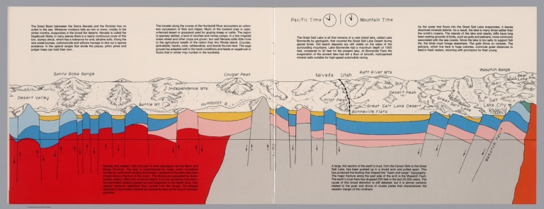
Geologic cross section and map. Covers the Great Basin between Sierra Nevada and the Rockies. Showing the earth's crust from the Carson Sink to the Great Salt Lake. Relief shown pictorially. Includes time zone clocks, showing Pacific standard time and Mountain standard time. Includes descriptive text.
Author
Raymo, Chet
Full Title
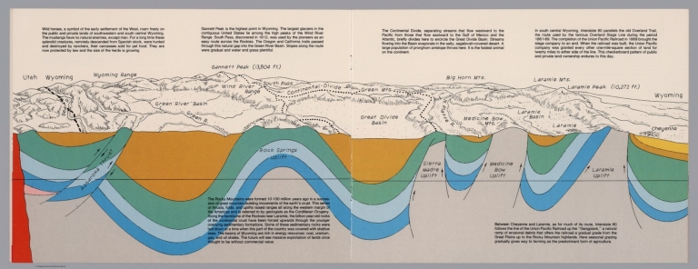
(Utah, Wayoming). (to accompany) A geologic and topographic profile of the United States along interstate 80 : by Chet Raymo. 1982. Printed by Hubbard, Northbrook, IL.
List No
13323.008
Note
Geologic cross section and map of Utah to Wyoming. Covers the area southwestern and south central Wyoming, showing the earth's crust, drainage and mountains. Relief shown pictorially and spot heights. "In the south central Wyoming, Interstate 80 parallels the Overland Trail". Includes descriptive text.
Author
Raymo, Chet
Full Title
(Great Plains, Nebraska). (to accompany) A geologic and topographic profile of the United States along interstate 80 : by Chet Raymo. 1982. Printed by Hubbard, Northbrook, IL.
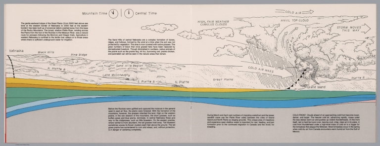
List No
13323.009
Note
Geologic cross section and topographic map of Great Plains, Nebraska. Showing weather system, dunes, ridges and vegetation. Relief shown pictorially. Includes time zone clocks, showing Mountain standard time and Central standard time. Includes descriptive text.
Author
Raymo, Chet
Full Title
(Nebraska, Iowa, Wisconsin). (to accompany) A geologic and topographic profile of the United States along interstate 80 : by Chet Raymo. 1982. Printed by Hubbard, Northbrook, IL.
List No
13323.010
Note
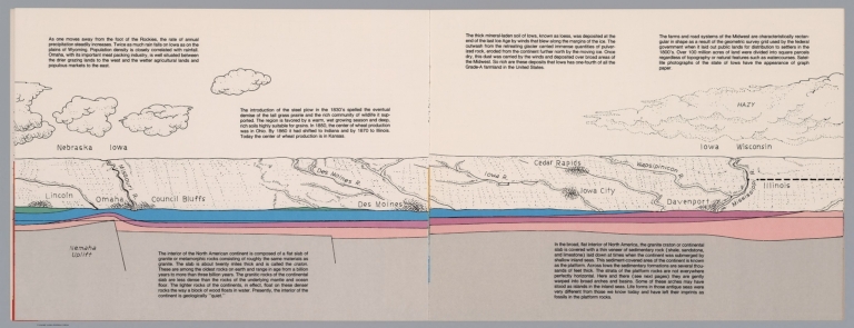
Geologic cross section and topographic map. Covers Lincoln, Nebraska to Davenport, Iowa and part of Illinois . Showing weather system, dunes, ridges and major cities. Includes descriptive text.
Author
Raymo, Chet
Full Title
(Illinois, Michigan). (to accompany) A geologic and topographic profile of the United States along interstate 80 : by Chet Raymo. 1982. Printed by Hubbard, Northbrook, IL.
List No
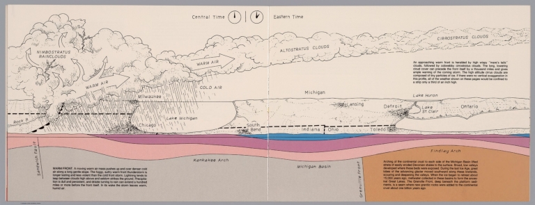
13323.011
Note
Geologic cross section and topographic map. Covers Illinois and Michigan, part of Indiana and Ohio . Showing weather system, dunes, ridges and major cities. Includes time zone clocks, showing Central standard time and Eastern standard time. Includes descriptive text.
Author
Raymo, Chet
Full Title
(New York, Connecticut, Atlantic Ocean). (to accompany) A geologic and topographic profile of the United States along interstate 80 : by Chet Raymo. 1982. Printed by Hubbard, Northbrook, IL.
List No
13323.013
Note
Geologic cross section and topographic map. Covers from Catskill Mts, New York to Atlantic Ocean. Showing weather system, rivers, ridges and major cities. Relief shown by hachures. Includes descriptive text.
Author
Becker, George F.
Full Title
(Covers to) Department Of The Interior, United States Geological Survey, Clarence King Director. Atlas To Accompany The Monograph On The Geology Of The Comstock Lode And The Washoe District By George F. Becker. Washington 1882. Julius Bien & Co. Lith. New York.
List No
1566A
Author
Becker, George F.
Full Title
(Title Page to) Department Of The Interior, United States Geological Survey, Clarence King Director. Atlas To Accompany The Monograph On The Geology Of The Comstock Lode And The Washoe District By George F. Becker. Washington 1882. Julius Bien & Co. Lith. New York.
List No
1566B
Note
An important atlas of the mining activity in the Comstock Lode. With printed color. Bound in brown cloth covered boards with "United States Geological Survey, Clarence King, Director. Atlas To Accompany The Geology Of The Comstock Lode And The Washoe District. Becker" stamped in gilt.
Author
Becker, George F.
Full Title
(Index to) Department Of The Interior, United States Geological Survey, Clarence King Director. Atlas To Accompany The Monograph On The Geology Of The Comstock Lode And The Washoe District By George F. Becker. Washington 1882. Julius Bien & Co. Lith. New York.
List No
1566C
Author
Becker, George F.
Full Title
Map of the Washoe District Showing Mining Claims. United States Geological Survey. Geology of the Comstock Lode, &c. Atlas Sheet III. Claims Mapped by Hoffman and Craven, 1881. Topography by U.S. Geographical Surveys West of the 100th Meridian. G.F. Becker, Geologist in Charge. Julius Bien & Co. Lith. N.Y.
List No
1566.001
Note
Map in color showing the mining claims in Washoe county. The dark blue lines indicate patented claims, and the dotted lines show claims for which patents have been applied. U.S. Survey and private survey lines are also included. Base map is topographic with contour intervals at 50 feet.
Author
Becker, George F.
Full Title
Geological Map of the Washoe District. United States Geological Survey. Geology of the Comstock Lode, &c. Atlas Sheet IV. Topography by U.S. Geographical Surveys West of the 100th Meridian. Geology by G.F. Becker, Geologist in Charge. Julius Bien & Co. Lith. N.Y.
List No
1566.002
Note
Map in full color showing geology of the same area as shown on the mining district map. Legend sits below the map.
Author
Becker, George F.
Full Title
Vertical Cross Sections of the Lode. United States Geological Survey. Geology of the Comstock Lode, &c. Atlas Sheet V. Mapping by R.H. Stretch. Geology by G.F. Becker, Geologist in Charge. Julius Bien & Co. Lith. N.Y.
List No
1566.003
Note
Four cross sections included: 1) Section through the Utah shaft; 2) Section through the Union shaft; 3) Section through the Sierra Nevada shaft; 4) Section through the C. and C. shaft. In full color with a legend explaining the diagrams.
Author
Becker, George F.
Full Title
Vertical Cross Sections of the Lode. United States Geological Survey. Geology of the Comstock Lode, &c. Atlas Sheet VI. Mapping by R.H. Stretch. Geology by G.F. Becker, Geologist in Charge. Julius Bien & Co. Lith. N.Y.
List No
1566.004
Note
Page includes the vertical section on line of Sutro Tunnel and through Baltimore and Forman Shafts. In full color with accompanying legend.
Author
Becker, George F.
Full Title
Vertical Cross Sections of the Lode. United States Geological Survey. Geology of the Comstock Lode, &c. Atlas Sheet VII. Mapping by R.H. Stretch. Geology by G.F. Becker, Geologist in Charge. Julius Bien & Co. Lith. N.Y.
List No
1566.005
Note
In full color and showing four maps: 1) Section through Hale and Northcross shaft; 2) Section through Belcher Mine; 3) Section through Yellow Jacket shafts; 4) Faulted structure on the Sutro tunnel section (at a scale of 1:9,600). With accompanying legend.
Author
Becker, George F.
Full Title
Horizontal Section of the Comstock Lode at the Sutro Tunnel Level (1900 ft.) and below. Horizontal Section of the Lode. North End. United States Geological Survey. Geology of the Comstock Lode, &c. Atlas Sheet VIII. Mapping by R.H. Stretch. Geology by G.F. Becker, Geologist in Charge. Julius Bien & Co. Lith. N.Y.
List No
1566.006
Note
In full color with the names of the shaft owners included on the map. An inset map shows the Comstock Lode at the 2,500 foot level.
Author
Becker, George F.
Full Title
Horizontal Section of the Comstock Lode at the Sutro Tunnel Level (1900 ft.) and below. Horizontal Section of the Lode. South End. United States Geological Survey. Geology of the Comstock Lode, &c. Atlas Sheet IX. Mapping by R.H. Stretch. Geology by G.F. Becker, Geologist in Charge. Julius Bien & Co. Lith. N.Y.
List No
1566.007
Note
In full color with an uncolored inset map showing the Comstock Lode at 2,400 feet and below. The owners of the shafts are shown.
Author
Becker, George F.
Full Title
Longitudinal Vertical Projection of the Comstock Lode. Number I. United States Geological Survey. Geology of the Comstock Lode, &c. Atlas Sheet X. Mapping by R.H. Stretch. G.F. Becker, Geologist in Charge. Julius Bien & Co. Lith. N.Y.
List No
1566.008
Note
Map without color. Map depicts mine shafts with areas of ore body extraction shown in gray.
Author
Becker, George F.
Full Title
Longitudinal Vertical Projection of the Comstock Lode. Number II. United States Geological Survey. Geology of the Comstock Lode, &c. Atlas Sheet XI. Mapping by R.H. Stretch. G.F. Becker, Geologist in Charge. Julius Bien & Co. Lith. N.Y.
List No
1566.009
Note
Map without color. Map depicts mine shafts with areas of ore body extraction shown in gray.
Author
Becker, George F.
Full Title
Longitudinal Vertical Projection of the Comstock Lode. Number III. United States Geological Survey. Geology of the Comstock Lode, &c. Atlas Sheet XII. Mapping by R.H. Stretch. G.F. Becker, Geologist in Charge. Julius Bien & Co. Lith. N.Y.
List No
1566.010
Note
Map without color. Map depicts mine shafts with areas of ore body extraction shown in gray.
Author
Becker, George F.
Full Title
Comstock Mine Maps. Number I. United States Geological Survey. Geology of the Comstock Lode, &c. Atlas Sheet XIII. Mapping by the Official Surveyors. G.F. Becker, Geologist in Charge. Julius Bien & Co. Lith. N.Y.
List No
1566.011
Note
Map showing the shafts and tunnels in color. The explanation states that separate colors are used to indicate each separate hundred feet of depth down to the 1500-foot level. The colors repeat between the 1500-foot and 3000-foot level.
Author
Becker, George F.
Full Title
Comstock Mine Maps. Number II. United States Geological Survey. Geology of the Comstock Lode, &c. Atlas Sheet XIV. Mapping by the Official Surveyors. G.F. Becker, Geologist in Charge. Julius Bien & Co. Lith. N.Y.
List No
1566.012
Note
Map showing the shafts and tunnels in color. The explanation states that separate colors are used to indicate each separate hundred feet of depth down to the 1500-foot level. The colors repeat between the 1500-foot and 3000-foot level.
Author
Becker, George F.
Full Title
Comstock Mine Maps. Number III. United States Geological Survey. Geology of the Comstock Lode, &c. Atlas Sheet XV. Mapping by the Official Surveyors. G.F. Becker, Geologist in Charge. Julius Bien & Co. Lith. N.Y.
List No
1566.013
Note
Map showing the shafts and tunnels in color. The explanation states that separate colors are used to indicate each separate hundred feet of depth down to the 1500-foot level. The colors repeat between the 1500-foot and 3000-foot level.
Author
Becker, George F.
Full Title
Comstock Mine Maps. Number IV. United States Geological Survey. Geology of the Comstock Lode, &c. Atlas Sheet XVI. Mapping by the Official Surveyors. G.F. Becker, Geologist in Charge. Julius Bien & Co. Lith. N.Y.
List No
1566.014
Note
Map showing the shafts and tunnels in color. The explanation states that separate colors are used to indicate each separate hundred feet of depth down to the 1500-foot level. The colors repeat between the 1500-foot and 3000-foot level.
Author
Becker, George F.
Full Title
Comstock Mine Maps. Number V. United States Geological Survey. Geology of the Comstock Lode, &c. Atlas Sheet XVII. Mapping by the Official Surveyors. G.F. Becker, Geologist in Charge. Julius Bien & Co. Lith. N.Y.
List No
1566.015
Note
Map showing the shafts and tunnels in color. The explanation states that separate colors are used to indicate each separate hundred feet of depth down to the 1500-foot level. The colors repeat between the 1500-foot and 3000-foot level.
Author
Becker, George F.
Full Title
Comstock Mine Maps. Number VI. United States Geological Survey. Geology of the Comstock Lode, &c. Atlas Sheet XVIII. Mapping by the Official Surveyors. G.F. Becker, Geologist in Charge. Julius Bien & Co. Lith. N.Y.
List No
1566.016
Note
Map showing the shafts and tunnels in color. The explanation states that separate colors are used to indicate each separate hundred feet of depth down to the 1500-foot level. The colors repeat between the 1500-foot and 3000-foot level.
Author
Becker, George F.
Full Title
Comstock Mine Maps. Number VII. United States Geological Survey. Geology of the Comstock Lode, &c. Atlas Sheet XIX. Mapping by the Official Surveyors. G.F. Becker, Geologist in Charge. Julius Bien & Co. Lith. N.Y.
List No
1566.017
Note
Map showing the shafts and tunnels in color. The explanation states that separate colors are used to indicate each separate hundred feet of depth down to the 1500-foot level. The colors repeat between the 1500-foot and 3000-foot level.
Author
Becker, George F.
Full Title
Comstock Mine Maps. Number VIII. United States Geological Survey. Geology of the Comstock Lode, &c. Atlas Sheet XX. Mapping by the Official Surveyors. G.F. Becker, Geologist in Charge. Julius Bien & Co. Lith. N.Y.
List No
1566.018
Note
Map showing the shafts and tunnels in color. The explanation states that separate colors are used to indicate each separate hundred feet of depth down to the 1500-foot level. The colors repeat between the 1500-foot and 3000-foot level.
Author
Becker, George F.
Full Title
Comstock Mine Maps. Number VIX. United States Geological Survey. Geology of the Comstock Lode, &c. Atlas Sheet XXI. Mapping by the Official Surveyors. G.F. Becker, Geologist in Charge. Julius Bien & Co. Lith. N.Y.
List No
1566.019
Note
Map showing the shafts and tunnels in color. The explanation states that separate colors are used to indicate each separate hundred feet of depth down to the 1500-foot level. The colors repeat between the 1500-foot and 3000-foot level.
Author
Berghaus, Hermann
Full Title
(Covers to) Atlas der Geologie. Berghaus' Physikalischer Atlas, Abteilung I. 15 kolorierte Karten in Kupferstich mit 150 Darstellungen. Unter beratender Mitwirkung von Prof. Dr. K. v. Zittel, bearbeitet von Dr. Hermann Berghaus, Professor in Gotha. Nach dem Tode des Verfassers in einigen Karten fertiggestellt von Dr. R. Luddecke, Dr. C. Rohrbach und Prof. Dr. Steinmann ... Gotha: Justus Perthes. 1892.
List No
1578A
Note
Bound in brown cloth covered boards with "Atlas der Geologie" stamped in gilt.
Author
Berghaus, Hermann
Full Title
(Title Page to) Atlas der Geologie. Berghaus' Physikalischer Atlas, Abteilung I. 15 kolorierte Karten in Kupferstich mit 150 Darstellungen. Unter beratender Mitwirkung von Prof. Dr. K. v. Zittel, bearbeitet von Dr. Hermann Berghaus, Professor in Gotha. Nach dem Tode des Verfassers in einigen Karten fertiggestellt von Dr. R. Luddecke, Dr. C. Rohrbach und Prof. Dr. Steinmann ... Gotha: Justus Perthes. 1892.
List No
1578B
Note
Title page including table of contents.
Author
Berghaus, Hermann
Full Title
Thatigkeit des Erdinnern. Vulkane und Strand-veranderungen in Mollweide's flachenrechter Erdansicht. Entw. v. Herm. Berghaus 1885, Ausg. 1888. Gotha: Justus Perthes (1892)
List No
1578.003
Note
Lithographed map, color. Ancillary maps: Jan Mayer, nordlichster Vulkan -- Erdbeben-Gebiete westliche -- Ostliche Erdbeben-Gebiete -- Insel Augustin (Tschernabura) -- Stromboli (Liparische Inseln) thatigster Vulkan -- Santorin (Kykladen) -- Sunda Strasse -- Tengger-Gebirge & Semiru.
Author
[Berghaus, Hermann, Luddecke, Richard, Rohrbach, C.]
Full Title
Grund und Boden. Bearbeitet v. Dr. C. Rohrbach, Red. v. Dr. R. Luddecke. Ausgabe 1892. Gotha: Justus Perthes (1892)
List No
1578.004
Note
Lithographed map, color. Ancillary maps: Dunen des Nefud -- Sudliche Erdhalfte, Niederschlage im Juli -- Niederschlage im Januar, Nordliche Erdhalfte -- Dunen in Central Australien -- Dunen des Tharr -- Ostliche Areg -- Trockene Niederschlage.
Author
Berghaus, Hermann
Full Title
Eisverbreitung, einst und jetzt. Polar Ansicht der Erde in Lambert's flachenrechter Azimuthal-projection. (with) Der Rhein-Gletscher nach A. Favre. (with) Der Rhone Gletscher nach A. Falsan. (with) Seen-Gebiet in Nord-Amerika nach Chamberlin und Wright. (with) Die Europaischen Alpen. (with) Iseo-Gletscher nach Stroppani. (with) Der Loisach- und Inn-Gletscher n. Penck & Bayberger. (with) Die Sudlichen Alpen (Neu-Seeland) nach J. v. Haast. Entw. v. Herm. Berghaus 1884, Ausg. 1886. Gotha: Justus Perthes (1892)
List No
1578.005
Note
Lithographed map, color.
Author
Berghaus, Hermann
Full Title
Gletscherkarte. Entw. v. Herm. Berghaus 1885, Ausg. 1888. Gez. v. M. Risch. Gest. v. O. Hess, Berge v. F. Kogel. Gotha: Justus Perthes (1892)
List No
1578.006
Note
21 lithographed maps on 1 sheet, color. Relief shown by hachures and spot heights. Contents: Inlandeis des Frederickshaab-Gletschers nach J.A.D. Jensen -- Gronlandisches Binnen-Eis -- Justedals Bra -- Jotun Fjeld -- Berner Oberland -- Gletscher des Halbinsel Kenai (Alaska) -- Aus dem sudlichen Gronland n. G. Holm -- Gletscher des Mount Tacoma (nach dem Northern Transcontinental Survey) von Bailey Willis -- Gletscher des Mount Shasta (nach dem U.S. Geological Survey) von J.S. Diller -- Gletscher von Oisans -- Nevado de Chillan nach A. Philippi -- San Rafael Gletscher -- Oetzthaler Gruppe -- Glockner Gruppe -- Ross-Gletscher (Sud-Georgien) -- Gletscher des Adai Choch (Kaukasus) nach M. v. Dechy -- Hohe von Schneegrenzen und Gletscher-Enden -- Gletscher des Kasbek -- Serafschan Gletscher (Turkestan) nach I.W. Muschketow -- Neuseelandische Alpen nach R. v. Lendenfield.
Author
[Berghaus, Hermann, Luddecke, Richard, Rohrbach, C.]
Full Title
Ubersicht der Erde. (with) Wahrscheinliche Ausdehnung des Festlandes zur Jurazeit (nach Neumayr. with) Verbreitung der Kohle. (with) Verbreitung der jungen Kettengebirge und des pazifischen u. atlantischen Kustentypus. Bearbeitet v. Dr. R. Luddecke & Dr. C. Rohrbach. Ausgabe 1892. Gotha: Justus Perthes.
List No
1578.007
Note
Lithographed geologic map, color with 3 insets. Includes statistical tables.
Author
Berghaus, Hermann
Full Title
Europa. (with) Laki (Island) nach A. Helland 1886. (with) Vulcano vor dem Ausbruche von 1886. (with) Die Pyrenaeen nach Carez u. Vasseur. (with) Spitzbergen nach Natthorst & Suess. (with) Schonen nach d. Karte d. geol. Landesaufnahme. (with) Der Kaukasus nach F. Favre, Abich u. A. (with) Gletscher des Adai-Choch. Entw. v. Herm. Berghaus 1889, Ausg. 1889. Gest. v. A. Herrmann. Gotha: Justus Perthes (1892)
List No
1578.008
Note
Lithographed geologic map, color with 7 insets. Relief shown by spot heights. Shows mineral deposits.
Author
Berghaus, Hermann
Full Title
Alpenlander. (with) Aus den Dolomiten n. v. Mojsisovics. Entw. v. Herm. Berghaus 1889, Ausg. 1890. Gest. v. A. Herrmann. Gotha: Justus Perthes (1892)
List No
1578.009
Note
Lithographed geologic map, color with inset. Relief shown by spot heights. Includes geologic sections.
Author
Berghaus, Hermann
Full Title
Asien und Europa. (with) Japan von Dr. Edm. Naumann, Korea von Dr. C. Gottsche. (with) Indisches Salz-Gebirge. (with) Lavastrom des Asama Jama von J(ahr) 1783. (with) Java nach F. Junghulm. Entw. v. Herm. Berghaus 1887, Ausg. 1889. Gest. v. K. Poppey u. P. Grabhein. Gotha: Justus Perthes (1892)
List No
1578.010
Note
Lithographed geologic map, color with 4 insets. Relief shown by spot heights.
Author
Berghaus, Hermann
Full Title
Afrika. (with) Pic von Tenerife. (with) Bu-Chail-Gebirge (Algerien). (with) Kamerun-Gebirge. (with) Gebirgslauf des Congo. (with) Atlas-Lander. (with) Capland. (with) Kilima-Ndsharo. (with) Oase Chargeh nach K. v. Zittel. (with) Abyssinien. (with) Amba-Landschaft (Abyssinien). (with view) Magdala von Ost nach Zeichnung v. Th. v. Heuglin. Entw. v. Herm. Berghaus 1887, Ausg. 1888. 7 Nebenkarten gez. v. M. Risch, gest. v. A. Reichenbecher & F. Kogel. Gotha: Justus Perthes (1892)
List No
1578.011
Note
Lithographed geologic map, color with 11 insets. Relief shown by spot heights.
Author
Berghaus, Hermann
Full Title
Nord-Amerika. Ubersicht von Nord-Amerika. (with) Virginia-Silber-Minen. (with) Das Yosemite-Thal. (with) Landenge von Tehuantepec n. J.C. Spear 1871. (with) Landenge von Nicaragua. (with) Die Krater des Turrialba. (with) Landenge von Panama. (with) Seeboden der New-York-Bay. (with) Popocatepetl. (with) Citlaltepetl. (with) Canons des Colorado. (with) Yellowstone-National-Park. (with) Reykjanes und Geyser nach Th. Thoroddsen. Entw. v. Herm. Berghaus 1886, Ausg. 1887. Nebenkarten gez. v. M. Risch. Gotha: Justus Perthes (1892)
List No
1578.012
Note
Lithographed geologic map, color with 12 inset maps. Relief shown by spot heights. Some inset maps are topographic maps showing relief by hachures and spot heights.
Author
[Berghaus, Hermann, Luddecke, Richard, Steinmann, G.]
Full Title
Sud-Amerika. (with) Vulcan Descabezado. (with) Cordillere von Copiapo nach Brackenbusch, Domeyko, Stelzner und Steinmann. (with) Durchschnitt des Westabhanges der Cordillere von Copiapo nach G. Steinmann. (with) Minen von Callao. (with) Laguna de San Rafael. (with) Sierra Nevada de Cocui. (with) Durchschnitt des Sergipe-Alagoas Beckens nach J.C. Branner. Bearb. v. G. Steinmann u. H. Berghaus, red. v. R. Luddecke. Ausgabe 1891. Gest. v. F. Geyer. Gotha: Justus Perthes (1892)
List No
1578.013
Note
Lithographed geologic map, color, with 7 insets. Relief shown by spot heights.
Author
Berghaus, Hermann
Full Title
Oceanien. (with) Victoria nach Brough Smyth. (with) Tasmanien nach R.M. Johnston und C.P. Sprent. (with) Landenge von Auckland n.v. Hochstetter. (with) Das Seenland (Neu-Seeland) nach d. 10. Juni 1886. (with) Hawaii-Vulkane veranderungen bis 1886. Entw. v. H. Berghaus 1886, Ausg. 1888. Gotha: Justus Perthes (1892)
List No
1578.014
Note
Lithographed geologic map, color, with 19 insets. Small inset maps not given in full title: Honolulu (Sandwich-Inseln) -- Makatea (Tuamotu-Gruppe) -- Bolabola (Gesellschafts-Inseln) -- Totoya (Viti-Inseln) -- Niuafu (Tonga-Inseln) -- Tova Riff (Viti In.) -- Vuata Vatua (Ono In.) -- Nukufetau (der Ellice Gruppe) -- Taiara (Tuamotu In.) -- Washington -- Jervis -- Enderbury (Phoenix In.) -- Roto-Mahana der warme See vor d. 10. Juni 1886 -- Maunga Rei.
Author
[Bishop, F. M., De Motte, B. C., Geological and Geographical Survey of the Territories (U.S.), Powell, John Wesley, 1834-1902, Thompson, A. H. (Almon Harris), 1839-1906]
Full Title
Green River from the Union Pacific Rail Road to the mouth of White River, 1873 (geology). Department of the Interior. U.S. Geological and Geographical Survey of the Territories. Second Division. J.W. Powell, geologist in charge, A.H. Thompson, geographer, B.C. De Motte & F.M. Bishop, topographers. W.H. Graves del. Outlines engraved by S.J. Kubel. U.S. G. and G. Survey, 2d. Div. ... Geology of the Unita Mountains. (Julius Bien Lith.)
List No
2078.002
Note
Colored lithographed map. Relief shown by contours, spot heights and hachures. Shows distribution of 20 sedimentary groups and one eruptive rock Trachyte.
Author
[Geological and Geographical Survey of the Territories (U.S.), Powell, John Wesley, 1834-1902]
Full Title
Structure sections through the Uinta Mountains. U.S. G. and G. Survey, 2d. Div., J.W. Powell, geologist in charge. Geology of the Unita Mountains. (Julius Bien Lith.)
List No
2078.003
Note
Lithograph. Sections 1-11. Horizontal and vertical scale (ca. 1:153,440)
Author
[Geological and Geographical Survey of the Territories (U.S.), Powell, John Wesley, 1834-1902]
Full Title
Displacement diagrams derived from the Structure sections through the Uinta Mountains, pl. I. U.S. G. and G. Survey, 2d. Div., J.W. Powell, geologist in charge. Geology of the Unita Mountains. (Julius Bien Lith.)
List No
2078.004
Note
Lithograph. Diagrams no. 1-22. Horizontal and vertical scale (ca. 1:253,440)
Author
[Geological and Geographical Survey of the Territories (U.S.), Powell, John Wesley, 1834-1902]
Full Title
Stereogram of the displacements of the eastern portion of the Uinta Mountains. U.S. G. and G. Survey, 2d. Div., J.W. Powell, geologist in charge. Geology of the Unita Mountains. (Julius Bien Lith.)
List No
2078.005
Note
Lithograph. Horizontal and vertical scale (ca. 1:253,440)
Author
[Geological and Geographical Survey of the Territories (U.S.), Gilbert, Grove Karl, 1843-1918, Powell, John Wesley, 1834-1902]
Full Title
Bird's-eye view of a part of the Uinta Uplift. Designed by G.K. Gilbert. U.S. G. and G. Survey, 2d. Div., J.W. Powell, geologist in charge. Geology of the Unita Mountains. (Julius Bien Lith.)
List No
2078.006
Note
Lithograph. Block diagram of an area measuring 40 by 50 miles. Vertical and horizontal scales (ca. 1:156,000)
Author
[Geological and Geographical Survey of the Territories (U.S.), Powell, John Wesley, 1834-1902]
Full Title
Stereogram of the displacements of the Yampa Plateau. U.S. G. and G. Survey, 2d. Div., J.W. Powell, geologist in charge. Geology of the Unita Mountains. (Julius Bien Lith.)
List No
2078.007
Note
Lithograph. Horizontal and vertical scale (ca. 1:253,440)
Author
[Geological and Geographical Survey of the Territories (U.S.), Marvine, Archibald Robertson, 1848-1876, Powell, John Wesley, 1834-1902]
Full Title
No. 1. Structure section through the Aspen Mountain Uplift. No. 2. Displacement diagram derived from the above section. (with) Generalized structure section through the Park Mountains. By Archibald R. Marvine. U.S. G. and G. Survey, 2d. Div., J.W. Powell, geologist in charge. Geology of the Unita Mountains. (Julius Bien Lith.)
List No
2078.008
Note
Three lithographed sections. No. 1-2 Horizontal and vertical scale (ca. 1:253,440). Park Mountains section horizontal and vertical scale (ca. 1:792,000)
Author
[Leach, W.W., McInnes, William, Dowling, D.B.]
Full Title
(Covers to) The Coal Resources Of The World. Atlas. Edited By William McInnes, B.S., F.R.S.C.; D.B. Dowling, B.A.Sc., F.R.S.C., And W.W. Leach, B.A.Sc.; Of The Geological Survey Of Canada. Morang & Co., Limited, Publishers: Toronto, Canada. (seal) Geologorum Conventus Mente Et Malleo. XII 1913 Canada.
List No
2249.001
Note
Atlas is bound in tan heavy paper covers printed in black ink with the same information as the title page.
Author
[McInnes, William, Dowling, D.B., Leach, W.W.]
Full Title
(Title Page to) The Coal Resources Of The World. Atlas. Edited By William McInnes, B.S., F.R.S.C.; D.B. Dowling, B.A.Sc., F.R.S.C., And W.W. Leach, B.A.Sc.; Of The Geological Survey Of Canada. Morang & Co., Limited, Publishers: Toronto, Canada. (seal) Geologorum Conventus Mente Et Malleo. XII 1913 Canada.
List No
2249.002
Author
[McInnes, William, Dowling, D.B., Leach, W.W.]
Full Title
(Title Page Verso to) Copyright, 1913, By Morang & Co., Limited, Toronto, Canada. Murray Printing Co. Limited, Toronto, Canada.
List No
2249.003
Author
[McInnes, William, Dowling, D.B., Leach, W.W.]
Full Title
(Table of Contents to) The Coal Resources Of The World. Atlas. Edited By William McInnes, B.S., F.R.S.C.; D.B. Dowling, B.A.Sc., F.R.S.C., And W.W. Leach, B.A.Sc.; Of The Geological Survey Of Canada. Morang & Co., Limited, Publishers: Toronto, Canada. (seal) Geologorum Conventus Mente Et Malleo. XII 1913 Canada. (on verso) Copyright, 1913, By Morang & Co., Limited, Toronto, Canada. Murray Printing Co. Limited, Toronto, Canada.
List No
2249.004
Author
[McInnes, William, Dowling, D.B., Leach, W.W.]
Full Title
Coal Resources of the World. Hemispheres. Map No. 1. Western Hemisphere. Eastern Hemisphere.
List No
2249.005
Note
Differentiates Tertiary, Mesozoic, and Paleozoic coal fields by color.
Author
Pittman, E.F.
Full Title
Coal Resources of the World. New South Wales, Australia. Map No. 2. Map of New South Wales Showing the Areas Occupied by the Coal Measures. E.F. Pittman, A.R.S.M., Government Geologist.
List No
2249.006
Note
Coal fields labeled in red.
Author
[Pittman, E.F., David, T.W.E.]
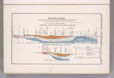
Full Title
Coal Resources of the World. New South Wales, Australia. Map No. 3. Geological Sections Showing the Structure of the Main Coal Basin of New South Wales Compiled Chiefly from Surveys by Professor T.W.E. David, C.M.G., B.A., F.R.S., F.G.S. E.F. Pittman, A.R.S.M., Government Geologist. Longitudinal Section from the Clyde River to Singleton. Transverse Section from Rydal to the Coast.
List No
2249.007
Author
Dunstan, B.
Full Title
Coal Resources of the World. Queensland, Australia. Map No. 4. Queensland Showing Principal Coal Areas. B. Dunstan, F.G.S. Government Geologist.
List No
2249.008
Note
Shows railroads.
Author
Woodward, H.P.
Full Title
Coal Resources of the World. West Australia. Map No. 5. Collie Coalfield with Amended Boundaries of the Collie Coal Measure Basin by H.P. Woodward. Assistant Government Geologist.
List No
2249.009
Note
Covers Collie Coal Mining District. Shows locations of longitudinal sections shown on 2249.010.
Full Title
Coal Resources of the World. West Australia. Map No. 6. Collie Coalfield Longitudinal Section.
List No
2249.010
Note
See 2249.009 for location of cross-section.
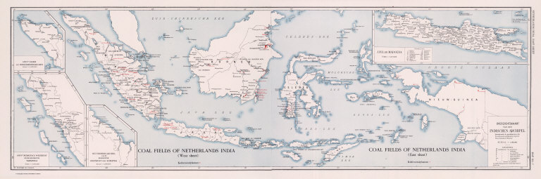
Full Title
Coal Resources of the World. Coal Fields of Netherlands India. (West Sheet) (East Sheet) Overzichtskaart van den Indischen Archipel. Map No. 7.
List No
2249.011
Note
In Dutch.
Full Title
(Composite) Coal Fields of Netherlands India. Overzichtskaart van den Indischen Archipel. Coal Resources of the World. (inset) Gouvt. Atjeh en Onderhoorigheden. (inset) Gouvt. Sumatra's Westkust en de Residentie Tapanoeli. (inset) Het Noordelijk Deel van de Residentie Oostkust van Sumatra. (inset) Java en Madoera.
List No
2249.012
Full Title
Coal Resources of the World. Netherlands India. Map No. 8. Oversichtskaart van het Ombilin Kolenveld.
List No
2249.013
Note
In Dutch.
Full Title
Coal Resources of the World. China. Map No. 9. Map Showing Distribution of Coal in China.
List No
2249.014
Note
Coal mapped in color.
Full Title
Coal Resources of the World. Corea. Map No. 10. Plate I. Map Showing the Distribution of Coal in Corea.
List No
2249.015
Note
Coal in color.
Author
[Kawasaki, H., Tamura, E.]
Full Title
Coal Resources of the World. Corea. Map No. 11. Plate II. Phyong-Yang Coal Field after H. Kawasaki, E. Tamura.
List No
2249.016
Note
In color.
Author
[Ogawa, T., Kido, C.]
Full Title
Coal Resources of the World. Manchuria. Map No. 12. Plate I. Map Showing Showing the Distribution of Coal in Manchuria. (inset) Hsing-King. Plate II. Fu-Shun Coal Field. After T. Ogawa and C. Kido.
List No
2249.017
Note
Two maps on one sheet. Fu-Shun map at 1:85,000.
Full Title
Coal Resources of the World. Manchuria. Map No. 13. Plate III. Section of Coal Seams in Fu-Shun Coal Fields.
List No
2249.018
Full Title
Coal Resources of the World. Japan. Map No. 14. Plate I. Map Showing the Distribution of Coal in Japan. (inset) (Vicinity map of Japan in Asia). (inset) Taiwan.
List No
2249.019
Note
Coal areas shown in color.
Author
Oinouye, Y.
Full Title
Coal Resources of the World. Japan. Map No. 15. Plate II. Ishikari Coal Fields. After Y. Oinouye.
List No
2249.020
Note
Color.
Author
[Kido, C., Suzuki, F., Matsuda, S.]
Full Title
Coal Resources of the World. Japan. Map No. 16. Plate III. Chikuho Coal Field. After F. Suzuki, C. Kido and S. Matsuda.
List No
2249.021
Author
Otsuki, Y.
Full Title
Coal Resources of the World. Japan. Map No. 17. Plate IV. Karatsu and Sasebo Coal Fields. After Y. Otsuki.
List No
2249.022
Note
Coal fields in color.
Full Title
Coal Resources of the World. India. Map No. 18. Coal Fields of India and Adjacent Countries.
List No
2249.023
Note
Coal fields in color.
Full Title
Coal Resources of the World. Turkey. Map No. 19. Asiatic Turkey Showing Location of Known Coal Fields.
List No
2249.024
Note
Coal field locations shown in color.
Full Title
Coal Resources of the World. South Africa. Map No. 20. Section across the Witbank Coalfield.
List No
2249.025
Author
Dowling, D.B.
Full Title
Coal Resources of the World. Canada. Map No. 21. Plate 1. Coal Areas of Canada by D.B. Dowling.
List No
2249.026
Note
Coal areas in color.
Full Title
Coal Resources of the World. Canada. Map No. 22. Plate 2. Coal Fields of Nova Scotia, New Brunswick, Canada.
List No
2249.027
Note
Coal fields shown in color.
Full Title
Coal Resources of the World. Canada. Map No. 23. Plate 3. Sydney Coal Field.
List No
2249.028
Note
Coal shown in color.
Full Title
Coal Resources of the World. Canada. Map No. 27. Plate 8. Southern Vancouver Island, British Columbia.
List No
2249.029
Note
Coal fields in color.
Author
Campbell, Marius R.
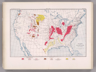
Full Title
Coal Resources of the World. United States. Map No. 28. Coal Fields of the United States by Marius R. Campbell.
List No
2249.030
Note
Coal fields shown in color.
Author
Strahan, A.
Full Title
Coal Resources of the World. England and Wales. Map No. 29. Map Showing Visible and Proved Coal Fields of England and Wales prepared under the direction of A. Strahan at the Geological Survey of Great Britain. London 1912.
List No
2249.031
Note
Coal fields in color.
Full Title
Coal Resources of the World. France. Map No. 30. Fig. 2. Carte du Bassin Houiller de Valenciennes. Fig. 3. Coupe E E Passant par Quievrechain. Fig. 4. Coupe D D Passant par Denain. Fig. 5. Coupe C C Passant par l'Escarpelle. Fig. 6. Coupe B B Passant par Meurchin, Lens et Lievin.
List No
2249.032
Note
Scale varies.
Full Title
Coal Resources of the World. France. Map No. 31. Fig. 7. Coupe A A Passant par Bruay. Fig 8. Coupe de Bassin du Boulonnais.... Fig. 10. Carte du Bassin de Ronchamp. Fig. 11. Carte du Bassin de Saint Etienne. Fig. 12. Coupe Transversale du Bassin de Saint-Etienne. Fig. 13. Carte des Bassins de Blanzy, Le Creusot Bert et Forges.
List No
2249.033
Note
Scale varies.
Full Title
Coal Resources of the World. France. Map No. 32. Fig. 14. Carte du Bassin d'Autun - Epinac. Fig. 15. Carte du Bassin de Decize. Fig. 16. Bassins de Commentry, Doyet l'Aumance et Noyant. Fig. 17. Coupe du Gisement de Saint Eloy.
List No
2249.034
Note
Scale varies.
Full Title
Coal Resources of the World. France. Map No. 33. Fig. 18. Carte du Bassin d'Aubin-Decazeville. Fig. 19. Coupe A B du Bassin d'Aubin-Decazeville. Fig. 20. Carte du Bassin de Carmaux-Albi. Fig. 21. Coupe du Bassin de Carmaux-Albi. Fig. 22. Carte du Bassin de Graissessac.
List No
2249.035
Full Title
Coal Resources of the World. France. Map No. 34. Fig. 23. Carte du Bassin d'Alais. Fig. 24. Coupe du Bassin d'Alais par Molieres et la Grand Combe. Fig. 25. Carte Geologique de la Region de la Mure.
List No
2249.036
Note
Scales vary. Color.
Full Title
Coal Resources of the World. France. Map No. 35. Fig. 26. Carte du Bassin de Fuveau. Fig. 27. Coupe S T du Bassin de Fuveau.
List No
2249.037
Note
In color.
Author
de Pann, Charles
Full Title
Coal Resources of the World. Hungary. Map No. 36. Carte des gisements houillers de la Hongrie par Charles de Pann docteur es sciences, 1912. A.M. Foldtani Tarsulat Tulajdona. Metsz. es Nyomt. Posner K. L. es FIA, terkepeszeti muintezete, Budapesten.
List No
2249.038
Note
Coal fields in color.
Author
Petrascheck, W.
Full Title
Coal Resources of the World. Austria. Map No. 37. Karte 1. Ubersichtskarte der Kphlenlager van Oesterreich bearbeitet von Dr. W. Petrascheck.
List No
2249.039
Note
Coal fields in color.
Author
Petrascheck, W.
Full Title
Coal Resources of the World. Austria. Map No. 38. Karte 2. Karte des Trifailer Braunkohlenrevieres ... W. Petrascheck.
List No
2249.040
Author
Petrascheck, W.
Full Title
Coal Resources of the World. Austria. Map No. 39. Karte 3. Ubersichtskarte de Voitsberg - Koflacher Braunkohlenrevieres ... W. Petrascheck.
List No
2249.041
Author
Petrascheck, W.
Full Title
Coal Resources of the World. Austria. Map No. 40. Karte 4. Uebersichts Karte des Teplitz-Brux-Komotauer Braunkohlenrevieres ... W. Petrascheck. Flotz-Profil....
List No
2249.042
Note
Color.
Author
Frieser, A.
Full Title
Coal Resources of the World. Austria. Map No. 41. Karte 5. Flotzkarten des Falkenau-Elbogen-Karlsbader Braunkohlenrevieres ... A. Frieser. Antono Flotz. Agnes Flotz. Josefi Flotz.
List No
2249.043
Author
Frieser, A.
Full Title
Coal Resources of the World. Austria. Map No. 42. Karte 6. Flotzlagerung in den Egerer Braunkohlenmulden ... A. Frieser.
List No
2249.044
Author
Petrascheck, W.
Full Title
Coal Resources of the World. Austria. Map No. 43. Karte 7. Ubersichtskarte des Kladno-Rakonitzer Steinkohlenrevieres ... W. Petrascheck.
List No
2249.045
Note
In color.
Author
Petrascheck, W.
Full Title
Coal Resources of the World. Karte 8. Map No. 44. Karte des Ostrau - Karwin - Krakauer Steinkohlenrevieres entworfen von W. Petrascheck.
List No
2249.046
Note
In color.
Author
Milojkovitch, J.A.
Full Title
Coal Resources of the World. Servia. Map No. 45. Ubersichtskarte der Kohlenvorkommen im Konigreiche Serbien von J.A. Milojkovitch.
List No
2249.047
Full Title
Coal Resources of the World. Roumania. Map No. 46. Esquisse de la distribution des Charbons en Roumanie.
List No
2249.048
Author
Erdmann, Edvard
Full Title
Coal Resources of the World. Sweden. Map No. 47. Geological Map of Skane Compiled by Edvard Erdmann. 1909.
List No
2249.049
Author
[Nathorst, A.G., De Geer, Backlund, Bruce, Hoel]
Full Title
Coal Resources of the World. Spitzbergen (Norway). Map No. 48. Geological Map of Spitzbergen from the Maps of Nordenskiold, De Geer, Tschernyschew, Backlund, Bruce, Hoel, and personal observations by A.G. Nathorst.
List No
2249.050
Note
Color.
Author
[Hitchcock, Charles H. (Charles Henry), 1836-1919, New Hampshire. Geological Survey]
Full Title
(Title Page to) Atlas accompanying the report on the geology of New Hampshire. C.H. Hitchcock, State Geologist. 1878. Julius Bien, New York.
List No
3095A
Note
17 maps and plates as called for in Vol III, p.vii of text. Huge folio atlas with 2 plates of views, 2 facsimiles (Carrigain 1816 and Holland 1784), 1 diagram or Camera view, a 6 sheet Geological Map of the state, a 5 (of 6, as issued) sheet Map of the state's Surface Geology, and a map of the Ammonoosuc Mining District. The upper northwest sheet of the Surface Geology map was not printed because it is entirely of Vermont, except for a tiny part of the lower right corner which was covered by making the uppper northeast sheet about one inch wider in the Surface Geology issue than it is in the Geological (six sheet) issue. The matter is further confused by Sabin calling for 16 plates and Phillips and LeGear calling for 9. Cobb calls for 17 and the most important list, in the text of the report itself, calls for 17. We believe this was the only large folio Geological Atlas made of an eastern state, on the scale of the western survey atlases of Powell, Hayden, Wheeler and King, during the same period. Most maps have printed color although the Ammonoosuc Mining District map is fully hand colored.
Author
[Hitchcock, Charles H. (Charles Henry), 1836-1919, New Hampshire. Geological Survey]
Full Title
(General geological map of New Hampshire, embracing portions of Maine, Vermont, and Quebec. Sheet 1. Julius Bien, New York, 1878)
List No
3095.005
Note
Col. lithographed map. Sheet 1 of 6. Includes explanation and 5 cross sections. Vertical and horizontal scale 2 1/2 miles to an in. Contour inverval 100 ft. Title from Marcou. Explanation is in v. 2, p. 672 of "Geology of New Hampshire."
Author
[Hitchcock, Charles H. (Charles Henry), 1836-1919, New Hampshire. Geological Survey]
Full Title
(General geological map of New Hampshire, embracing portions of Maine, Vermont, and Quebec. Sheet 2. Julius Bien, New York, 1878)
List No
3095.006
Note
Col. lithographed map. Sheet 2 of 6. Includes explanation and 5 cross sections. Vertical and horizontal scale 2 1/2 miles to an in. Contour inverval 100 ft. Title from Marcou. Explanation is in v. 2, p. 672 of "Geology of New Hampshire."
Author
[Hitchcock, Charles H. (Charles Henry), 1836-1919, New Hampshire. Geological Survey]
Full Title
(General geological map of New Hampshire, embracing portions of Maine, Vermont, and Quebec. Sheet 3. Julius Bien, New York, 1878)
List No
3095.007
Note
Col. lithographed map. Sheet 3 of 6. Includes explanation and 4 cross sections. Vertical and horizontal scale 2 1/2 miles to an in. Contour inverval 100 ft. Title from Marcou. Explanation is in v. 2, p. 672 of "Geology of New Hampshire."
Author
[Hitchcock, Charles H. (Charles Henry), 1836-1919, New Hampshire. Geological Survey]
Full Title
(General geological map of New Hampshire, embracing portions of Maine, Vermont, and Quebec. Sheet 4. Julius Bien, New York, 1878)
List No
3095.008
Note
Col. lithographed map. Sheet 4 of 6. Includes explanation and 4 cross sections. Vertical and horizontal scale 2 1/2 miles to an in. Contour inverval 100 ft. Title from Marcou. Explanation is in v. 2, p. 672 of "Geology of New Hampshire."
Author
[Hitchcock, Charles H. (Charles Henry), 1836-1919, New Hampshire. Geological Survey]
Full Title
(General geological map of New Hampshire, embracing portions of Maine, Vermont, and Quebec. Sheet 5. Julius Bien, New York, 1878)
List No
3095.009
Note
Col. lithographed map. Sheet 5 of 6. Includes explanation and 5 cross sections. Vertical and horizontal scale 2 1/2 miles to an in. Contour inverval 100 ft. Title from Marcou. Explanation is in v. 2, p. 672 of "Geology of New Hampshire."
Author
[Hitchcock, Charles H. (Charles Henry), 1836-1919, New Hampshire. Geological Survey]
Full Title
(General geological map of New Hampshire, embracing portions of Maine, Vermont, and Quebec. Sheet 6. Julius Bien, New York, 1878)
List No
3095.010
Note
Col. lithographed map. Sheet 6 of 6. Includes explanation and 5 cross sections. Vertical and horizontal scale 2 1/2 miles to an in. Contour inverval 100 ft. Title from Marcou. Explanation is in v. 2, p. 672 of "Geology of New Hampshire."
Author
[Hitchcock, Charles H. (Charles Henry), 1836-1919, New Hampshire. Geological Survey]
Full Title
(Composite of General geological map of New Hampshire, embracing portions of Maine, Vermont, and Quebec. Julius Bien, New York, 1878)
List No
3095.011
Note
Col. lithographed map on 6 sheets. Each sheet includes explanation and 4-5 cross sections. Vertical and horizontal scale 2 1/2 miles to an in. Contour inverval 100 ft. Title from Marcou. Explanation is in v. 2, p. 672 of "Geology of New Hampshire." Covers adjacent areas of Maine, Vermont and Quebec.
Author
[Hitchcock, Charles H. (Charles Henry), 1836-1919, New Hampshire. Geological Survey]
Full Title
(Topographic and glacial feature map of New Hampshire. Sheet 1. Julius Bien, New York, 1878)
List No
3095.012
Note
Col. lithographed map. Sheet 1 of 5. Shows townships, grants, railroads, areas of glacial striae, lenticular hills, slopes of till, modified drift, etc. Scale (2 1/2 miles to an in.) Contour inverval 100 ft.
Author
[Hitchcock, Charles H. (Charles Henry), 1836-1919, New Hampshire. Geological Survey]
Full Title
(Topographic and glacial feature map of New Hampshire. Sheet 2. Julius Bien, New York, 1878)
List No
3095.013
Note
Col. lithographed map. Sheet 2 of 5. Shows townships, grants, railroads, areas of glacial striae, lenticular hills, slopes of till, modified drift, etc. Scale (2 1/2 miles to an in.) Contour inverval 100 ft.
Author
[Hitchcock, Charles H. (Charles Henry), 1836-1919, New Hampshire. Geological Survey]
Full Title
(Topographic and glacial feature map of New Hampshire. Sheet 3. Julius Bien, New York, 1878)
List No
3095.014
Note
Col. lithographed map. Sheet 3 of 5. Shows townships, grants, railroads, areas of glacial striae, lenticular hills, slopes of till, modified drift, etc. Scale (2 1/2 miles to an in.) Contour inverval 100 ft.
Author
[Hitchcock, Charles H. (Charles Henry), 1836-1919, New Hampshire. Geological Survey]
Full Title
(Topographic and glacial feature map of New Hampshire. Sheet 4. Julius Bien, New York, 1878)
List No
3095.015
Note
Col. lithographed map. Sheet 4 of 5. Shows townships, grants, railroads, areas of glacial striae, lenticular hills, slopes of till, modified drift, etc. Scale (2 1/2 miles to an in.) Contour inverval 100 ft.
Author
[Hitchcock, Charles H. (Charles Henry), 1836-1919, New Hampshire. Geological Survey]
Full Title
(Topographic and glacial feature map of New Hampshire. Sheet 5. Julius Bien, New York, 1878)
List No
3095.016
Note
Col. lithographed map. Sheet 5 of 5. Shows townships, grants, railroads, areas of glacial striae, lenticular hills, slopes of till, modified drift, etc. Scale (2 1/2 miles to an in.) Contour inverval 100 ft.
Author
[Hitchcock, Charles H. (Charles Henry), 1836-1919, New Hampshire. Geological Survey]
Full Title
(Composite of Topographic and glacial feature map of New Hampshire. Sheet 5. Julius Bien, New York, 1878)
List No
3095.017
Note
Col. lithographed map. Sheet 5 of 5. Shows townships, grants, railroads, areas of glacial striae, lenticular hills, slopes of till, modified drift, etc. Scale (2 1/2 miles to an in.) Contour inverval 100 ft. Issued in 5 sheets (6th would have been upper left sheet not covering New Hampshire).
Author
[Hitchcock, Charles H. (Charles Henry), 1836-1919, New Hampshire. Geological Survey]
Full Title
Map of the Ammonoosuc Mining District. (Julius Bien, New York, 1878) The Heliotype Printing Co. 220 Devonshire St., Boston.
List No
3095.018
Note
Hand col. lithographed map. Shows geological units, mines, townships, etc. Contour inverval 100 ft. Oriented with north toward upper left.
Author
Hague, Arnold
Full Title
(Covers to) Department Of The Interior, United States Geological Survey, Charles D. Walcott, Director. Atlas To Accompany Monograph XXXII On The Geology Of The Yellowstone National Park, By Arnold Hague. Washington, 1904. Julius Bien & Co. Lith. N.Y.
List No
4252A
Note
Bound in original dark brown cloth covered boards with "United States Geological Survey, Charles D. Walcott, Director. Atlas To Accompany Monograph XXXII On The Geology Of The Yellowstone National Park. Arnold Hague" stamped in gilt.
Author
Hague, Arnold
Full Title
(Title Page to) Department Of The Interior, United States Geological Survey, Charles D. Walcott, Director. Atlas To Accompany Monograph XXXII On The Geology Of The Yellowstone National Park, By Arnold Hague. Washington, 1904. Julius Bien & Co. Lith. N.Y.
List No
4252B
Author
Hague, Arnold
Full Title
(Table of Contents to) Department Of The Interior, United States Geological Survey, Charles D. Walcott, Director. Atlas To Accompany Monograph XXXII On The Geology Of The Yellowstone National Park, By Arnold Hague. Washington, 1904. Julius Bien & Co. Lith. N.Y.
List No
4252C
Author
Hague, Arnold
Full Title
(Legend to) Department Of The Interior, United States Geological Survey, Charles D. Walcott, Director. Atlas To Accompany Monograph XXXII On The Geology Of The Yellowstone National Park, By Arnold Hague. Washington, 1904. Julius Bien & Co. Lith. N.Y.
List No
4252D
Note
This page is a detailed description of the atlas and some of the geologic processes in Yellowstone National Park.
Author
Hague, Arnold
Full Title
Gallatin Sheet. Geology Sheet X. Monograph XXXII. Yellowstone National Park. U.S. Geological Survey. Charles D. Walcott, Director. 1904. Julius Bien & Co. Lith. N.Y. Henry Gannett, Chief Geographer. J.H. Renshawe, Geographer in charge. Triangulation by H.S. Chase. Topography by J.H. Renshawe, Frank Tweedy, H.S. Chase, and S.A. Alpin Jr. Surveyed in 1883-5. Geology by Arnold Hague, Geologist in charge, Joseph Paxson Iddings, Walter Harvey Weed, and George M. Wright, Surveyed 1883 to 91, and 93.
List No
4252.007
Note
Topography shown in 100-foot contours, overlaid in color with 26 classes of rock types, and faults. Legend.
Author
Hague, Arnold
Full Title
Shoshone Sheet. Geology Sheet XI. Monograph XXXII. Yellowstone National Park. U.S. Geological Survey. Charles D. Walcott, Director. 1904. Julius Bien & Co. Lith. N.Y. Henry Gannett, Chief Geographer. J.H. Renshawe, Geographer in charge. Triangulation by H.S. Chase. Topography by W.H. Leffingwell, Frank Tweedy, J.H. Renshawe, and S.A. Alpin Jr. Surveyed in 1884-5. Geology by Arnold Hague, Geologist in charge, Joseph Paxson Iddings, and Walter Harvey Weed, Surveyed 1883 to 91, and 1893.
List No
4252.008
Note
Topography shown in 100-foot contours, overlaid in color with 22 classes of rock types, and faults. Legend.
Author
Hague, Arnold
Full Title
Canyon Sheet. Geology Sheet XII. Monograph XXXII. Yellowstone National Park. U.S. Geological Survey. Charles D. Walcott, Director. 1904. Julius Bien & Co. Lith. N.Y. Henry Gannett, Chief Geographer. J.H. Renshawe, Geographer in charge. Triangulation by H.S. Chase. Topography by Frank Tweedy. Surveyed in 1884-5. Geology by Arnold Hague, Geologist in charge, Joseph Paxson Iddings, Walter Harvey Weed, and George M. Wright, Surveyed 1883 to 91, and 93.
List No
4252.009
Note
Topography shown in 100-foot contours, overlaid in color with 22 classes of rock types, and faults. Legend.
Author
Hague, Arnold
Full Title
Lake Sheet. Geology Sheet VII. Monograph XXXII. Yellowstone National Park. U.S. Geological Survey. Charles D. Walcott, Director. 1904. Julius Bien & Co. Lith. N.Y. Henry Gannett, Chief Geographer. J.H. Renshawe, Geographer in charge. Triangulation by H.S. Chase. Topography by J.H. Renshawe. Surveyed in 1885. Geology by Arnold Hague, Geologist in charge, Joseph Paxson Iddings, and Walter Harvey Weed, Surveyed 1883 to 89, and 93.
List No
4252.010
Note
Topography shown in 100-foot contours, overlaid in color with 22 classes of rock types, and faults. Legend.
Author
Hague, Arnold
Full Title
Crandall Sheet. Geology Sheet VIII. Monograph XXXII. Yellowstone National Park. U.S. Geological Survey. Charles D. Walcott, Director. 1904. Julius Bien & Co. Lith. N.Y. A. H. Thompson, Geographer. Triangulation and Topography by Frank Tweedy. Surveyed in 1893. Geology by Arnold Hague, Geologist in charge, Assisted by Joseph P. Iddings and Thomas A. Jaggar Jr., Surveyed in 1893 and 1897.
List No
4252.011
Note
Topography shown in 100-foot contours, overlaid in color with 15 classes of rock types, and dikes and faults. Legend.
Author
Hague, Arnold
Full Title
Ishawooa Sheet. Geology Sheet XV. Monograph XXXII. Yellowstone National Park. U.S. Geological Survey. Charles D. Walcott, Director. 1904. Julius Bien & Co. Lith. N.Y. A. H. Thompson, Geographer. Triangulation and Topography by Frank Tweedy. Surveyed in 1893. Geology by Arnold Hague, Geologist in charge, Assisted by Thomas A. Jaggar Jr., Surveyed in 1893 and 1897.
List No
4252.012
Note
Topography shown in 100-foot contours, overlaid in color with 11 classes of rock types, and dikes and faults. Legend.
Author
Hague, Arnold
Full Title
Yellowstone National Park and Portion of Yellowstone Forest Reserve. Geology Sheet XVII. Monograph XXXII. Yellowstone National Park. U.S. Geological Survey. Charles D. Walcott, Director. 1904. Julius Bien & Co. Lith. N.Y. Geology by Arnold Hague, Geologist in charge, Assisted by Joseph P. Iddings, Walter Harvey Weed, George M. Wright, and Thomas A. Jaggar Jr.
List No
4252.014
Note
Topography shown in 100-foot contours, overlaid in vibrant color with 34 classes of rock types, and dikes and faults. Legend.
Author
Hague, Arnold
Full Title
Mammoth Hot Springs and Vicinity. Geology Sheet XIX. Monograph XXXII. Yellowstone National Park. U.S. Geological Survey. Charles D. Walcott, Director. 1904. Julius Bien & Co. Lith. N.Y. Topography by Anton Karl, assisted by Joseph R. Bien. Geology by Arnold Hague, Geologist in charge and Walter Harvey Weed.
List No
4252.016
Note
Topography shown in 20-foot contours, overlaid in color with 12 classes of rock types. Legend.
Author
Hague, Arnold
Full Title
Norris Geyser Basin. Geology Sheet XXI. Monograph XXXII. Yellowstone National Park. U.S. Geological Survey. Charles D. Walcott, Director. 1904. Julius Bien & Co. Lith. N.Y. Topography by Anton Karl, assisted by Joseph R. Bien. Geology by Arnold Hague and Walter Harvey Weed.
List No
4252.018
Note
Topography shown in 10-foot contours, overlaid in color with 6 classes of rock types. Legend.
Author
Hague, Arnold
Full Title
Firehole Geyser Basin. Geology Sheet XXII. Monograph XXXII. Yellowstone National Park. U.S. Geological Survey. Charles D. Walcott, Director. 1904. Julius Bien & Co. Lith. N.Y. Topography by Anton Karl, assisted by Joseph R. Bien. Geology by Arnold Hague, Geologist in charge, and Walter Harvey Weed.
List No
4252.019
Note
Topography shown in 10-foot contours, overlaid in color with 6 classes of rock types. Legend.
Author
Hague, Arnold
Full Title
Excelsior Geyser Basin. Geology Sheet XXIII. Monograph XXXII. Yellowstone National Park. U.S. Geological Survey. Charles D. Walcott, Director. 1904. Julius Bien & Co. Lith. N.Y. Topography by Anton Karl, assisted by Joseph R. Bien. Geology by Arnold Hague and Walter Harvey Weed.
List No
4252.020
Note
Topography shown in 5-foot contours, overlaid in color with 4 classes of rock types. Legend.
Author
Hague, Arnold
Full Title
Upper Geyser Basin. Geology Sheet XXIV. Monograph XXXII. Yellowstone National Park. U.S. Geological Survey. Charles D. Walcott, Director. 1904. Julius Bien & Co. Lith. N.Y. Topography by Anton Karl, assisted by Joseph R. Bien. Geology by Arnold Hague, Geologist in charge, and Walter Harvey Weed.
List No
4252.021
Note
Topography shown in 20-foot contours, overlaid in color with 5 classes of rock types. Legend.
Author
Hague, Arnold
Full Title
Shoshone Geyser Basin. Geology Sheet XXVI. Monograph XXXII. Yellowstone National Park. U.S. Geological Survey. Charles D. Walcott, Director. 1904. Julius Bien & Co. Lith. N.Y. Topography by Anton Karl, assisted by Joseph R. Bien. Surveyed by Hayden Survey, 1878, revised and contours added by Walter Harvey Weed. Geology by Walter Harvey Weed.
List No
4252.023
Note
Topography shown in 5-foot contours, overlaid in color with 5 classes of rock types. Legend.
Author
Hague, Arnold
Full Title
The Shores of Yellowstone Lake. Geology Sheet XXVII. Monograph XXXII. Yellowstone National Park. U.S. Geological Survey. Charles D. Walcott, Director. 1904. Julius Bien & Co. Lith. N.Y. A.H. Thompson, Geographer. Topography by Frank E. Grove, Philip Sawyer under charge of Frank Tweedy. Suveryed in 1889. Arnold Hague, Geologist in charge. Geology by Walter Harvey Weed.
List No
4252.024
Note
Topography shown in 20-foot contours, overlaid in color with 7 classes of rock types. Legend. Note provided on the survey history and on the geomorphic history of Yellowstone Lake.
Author
Becker, George F.
Full Title
(Title Page to) Department Of The Interior, United States Geological Survey, J.W. Powell Director. Atlas to Accompany a Monograph on The Geology of the Quicksilver Deposits of the Pacific Slope By George F. Becker. Washington 1887. Giles Litho. & Liberty Printing Co. N.Y.
List No
4580B
Author
Becker, George F.
Full Title
(Table of Contents to) Department Of The Interior, United States Geological Survey, J.W. Powell Director. Atlas to Accompany a Monograph an The Geology of the Quicksilver Deposits of the Pacific Slope By George F. Becker. Washington 1887. Giles Litho. & Liberty Printing Co. N.Y.
List No
4580C
Author
Becker, George F.
Full Title
Geological Map of the Clear Lake District. U.S. Geological Survey. Monograph XIII, Atlas Sheet III. Topography compiled by C.F. Hoffmann. Giles Litho. & Liberty Printing Co. Geo. F. Becker, Geologist in charge.
List No
4580.001
Note
Shows in color six classes of rock. Streams and settlements shown including borax works. Outline of Plate IV shown.
Author
Becker, George F.
Full Title
Geological Map of the Sulphur Bank District. U.S. Geological Survey. Monograph XIII, Atlas Sheet IV. S.H. Bodfish 1882, J.D. Hoffman 1884, Topographers. Giles Litho. & Liberty Printing Co. Geo. F. Becker, Geologist in charge.
List No
4580.002
Note
Shows in color three classes of rock. Relief shown by 20-foot contour lines. Shows mines, streams, and settlements.
Author
Becker, George F.
Full Title
Geological Map of the Knoxville District. U.S. Geological Survey. Monograph XIII, Atlas Sheet V. Topography by J.D. Hoffman 1883. Geo. F. Becker, Geologist in charge. Topographical Map of the Region of Clear Lake. Compiled by C.F. Hoffmann. Geo. F. Becker, Geologist in charge.
List No
4580.003
Note
Two maps on one sheet. Knoxville District map relief shown with 25-foot contours. Shows in color five classes of rock. Longitude and latitude shown. Scale 1:15,000. Clear Lake Region map shows topography with shaded relief, streams, mines, settlements, and roads. Scale 1:95,000. Outlines of Sulphur Bank District and Knoxville District shown.
Author
Becker, George F.
Full Title
Geological Map of the New Idria District. U.S. Geological Survey. Monograph XIII, Atlas Sheet VI. J.D. Hoffman, Topographer. Giles Litho. & Liberty Printing Co. N.Y. Geo. F. Becker, Geologist in charge.
List No
4580.004
Note
Shows in color three classes of rock. Relief shown by 40-foot contour lines. Shows streams, settlements, mines, trails, and roads.
Author
Becker, George F.
Full Title
Geological Map of the New Almaden Mining District. U.S. Geological Survey. Monograph XIII, Atlas Sheet VII. Topography by S.W. Bodfish and others. Giles Litho. & Liberty Printing Co. N.Y. Geo. F. Becker, Geologist in charge.
List No
4580.005
Note
Shows in color six classes of rock. Relief shown by 20-foot contour lines. Shows streams, settlements, mines, and roads.
Author
Becker, George F.
Full Title
Ore-Bodies and Topography of Mine-Hill, New Almaden. U.S. Geological Survey. Monograph XIII, Atlas Sheet VIII. Compiled by F. Reade 1885. Giles Litho. & Liberty Printing Co. N.Y. Geo. F. Becker, Geologist in charge.
List No
4580.006
Note
Shows in topography with 10-foot contours, ore bodies with cross-hatching, mine dumps with hachures, +streams, roads, tramways, tunnels and shafts.
Author
Becker, George F.
Full Title
Plan of the New Almaden Mine. U.S. Geological Survey. Monograph XIII, Atlas Sheet IX. Compiled by F. Reade 1885. Giles Litho. & Liberty Printing Co. N.Y. Geo. F. Becker, Geologist in charge.
List No
4580.007
Note
Shows depths, tunnels, drifts, galleries, and shafts in brilliant color.
Author
Becker, George F.
Full Title
Longitudinal Section of the South Ore Channel. New Almaden Mine. U.S. Geological Survey. Monograph XIII, Atlas Sheet X. Compiled by F. Reade 1885. Giles Litho. & Liberty Printing Co. N.Y. Geo. F. Becker, Geologist in charge.
List No
4580.008
Note
Shows depths, tunnels, drifts, galleries, and shafts.
Author
Becker, George F.
Full Title
North and South Section , 550 Feet West of Randol Shaft, New Almaden Mine. North and South Section through the Randol Shaft, New Almaden Mine. U.S. Geological Survey. Monograph XIII, Atlas Sheet XI. Compiled by F. Reade 1885. Geo. F. Becker, Geologist in charge.
List No
4580.009
Note
Two vertical sections on one sheet. Shows depths, tunnels, drifts, galleries, and shafts.
Author
Becker, George F.
Full Title
East and West Vertical Section, New Almaden Mine. U.S. Geological Survey. Monograph XIII, Atlas Sheet XII. Compiled by F. Reade 1885. Geo. F. Becker, Geologist in charge.
List No
4580.010
Note
Shows depths, tunnels, drifts, galleries, and shafts.
Author
Becker, George F.
Full Title
Plan of the Clay Walls, New Almaden Mine. U.S. Geological Survey. Monograph XIII, Atlas Sheet XIII. Compiled by F. Reade 1885. Giles Litho. & Liberty Printing Co. N.Y. Geo. F. Becker, Geologist in charge.
List No
4580.011
Note
Shows alignments of clay walls.
Author
Becker, George F.
Full Title
Steam-Boat Springs, Nevada. U.S. Geological Survey. Monograph XIII, Atlas Sheet XIV. Topography by Eugene Ricksecker, 1885. Giles Litho. & Liberty Printing Co. N.Y. Geo. F. Becker, Geologist in charge.
List No
4580.012
Note
Topography shown by 20-foot contours. Ten classes of rocks shown in color. Streams, structures, railroads, roads, and benchmarks shown.
Author
Dutton, Clarence E. (Clarence Edward), 1841-1912
Full Title
(Covers to) Department Of The Interior, United States Geological Survey, J.W. Powell Director. Atlas To Accompany The Monograph On The Tertiary History Of The Grand Canon District By Capt. Clarence E. Dutton U.S.A. Washington 1882. Julius Bien & Co. Lith. New York.
List No
4713A
Author
Dutton, Clarence E. (Clarence Edward), 1841-1912
Full Title
(Title Page to) Department Of The Interior, United States Geological Survey, J.W. Powell Director. Atlas To Accompany The Monograph On The Tertiary History Of The Grand Canon District By Capt. Clarence E. Dutton U.S.A. Washington 1882. Julius Bien & Co. Lith. New York.
List No
4713B
Note
With superb panoramas by W.H. Holmes and Thomas Moran. This is one of the finest publications of U.S. Geological Survey. Full printed color. Bound in dark brown cloth covered boards with "United States Geological Survey J.W. Powell Director. Atlas To Accompany The Teriary History Of The Grand Canon District. Dutton" stamped in gilt.
Author
Dutton, Clarence E. (Clarence Edward), 1841-1912
Full Title
(Index to) Department Of The Interior, United States Geological Survey, J.W. Powell Director. Atlas To Accompany The Monograph On The Tertiary History Of The Grand Canon District By Capt. Clarence E. Dutton U.S.A. Washington 1882. Julius Bien & Co. Lith. New York.
List No
4713C
Author
Dutton, Clarence E. (Clarence Edward), 1841-1912
Full Title
Geological Map Of The Western Part Of The Plauteau Province. Sheet II. J.H. Renshawe, Del. Geology by C.E. Dutton, Geologist-in-Charge. Julius Bien, lith. N.Y. U.S. Geological Survey, Geology of the Grand Canon District.
List No
4713.001
Note
In full color with a guide below the map.
Author
Dutton, Clarence E. (Clarence Edward), 1841-1912
Full Title
Sketch Map of the Western Part of the Plateau Province showing The Faults of the Grand Canon District and High Plateaus. Sheet III. Julius Bien, lith. N.Y. C.E. Dutton, Geologist-in-Charge. U.S. Geological Survey, Geology of the Grand Canon District.
List No
4713.002
Note
Map without color.
Author
[Dutton, Clarence E. (Clarence Edward), 1841-1912, Holmes, William Henry, 1846-1933]
Full Title
The Temples and Towers of the Virgen. W(illiam) H. H(olmes). Atlas Sheet IV. Julius Bien & Co. lith. U.S. Geological Survey, Geology of the Grand Canon District.
List No
4713.003
Note
In full color. Note states "In the centre of the picture is the western temple. To the right of it is the Mukuntuweap Fork or Little Zion Valley and across it is the eastern temple. On the extreme right is the opening of the Parunuweap. In the middle distance is the inner Canon of the Virgen."
Author
[Dutton, Clarence E. (Clarence Edward), 1841-1912, Holmes, William Henry, 1846-1933]
Full Title
Looking up the Toroweap from Vulcan's Throne. W(illiam) H. H(olmes). Atlas Sheet V. Julius Bien & Co. lith. U.S. Geological Survey, Geology of the Grand Canon District.
List No
4713.004
Note
In full color. Two views are included on this Atlas Sheet. It is noted below that the two views are continuous. They show the lava streams and flows descending from the Craters and the Plateau.
Author
[Dutton, Clarence E. (Clarence Edward), 1841-1912, Holmes, William Henry, 1846-1933]
Full Title
The Grand Canon at the foot of the Toroweap - Looking East. W(illiam) H. H(olmes). Atlas Sheet VI. Julius Bien & Co. lith. U.S. Geological Survey, Geology of the Grand Canon District.
List No
4713.005
Note
In full color.
Author
Dutton, Clarence E. (Clarence Edward), 1841-1912
Full Title
Map Of The Uinkaret Plateau. North Half. Atlas Sheet VII. Geology by C.E. Dutton. Julius Bien & Co. lith. U.S. Geological Survey, Geology of the Grand Canon District.
List No
4713.006
Note
In full color.
Author
Dutton, Clarence E. (Clarence Edward), 1841-1912
Full Title
Map Of The Uinkaret Plateau. South Half. Atlas Sheet VIII. Geology by C.E. Dutton. Julius Bien & Co. lith. U.S. Geological Survey, Geology of the Grand Canon District.
List No
4713.007
Note
In full color.
Author
Dutton, Clarence E. (Clarence Edward), 1841-1912
Full Title
(Composite) Map Of The Uinkaret Plateau. North and South Half. Atlas Sheets VII and VIII. Geology by C.E. Dutton. Julius Bien & Co. lith. U.S. Geological Survey, Geology of the Grand Canon District.
List No
4713.008
Note
In full color. Composite map of sheets VII and VIII.
Author
[Dutton, Clarence E. (Clarence Edward), 1841-1912, Holmes, William Henry, 1846-1933]
Full Title
Views looking east and south from Mt. Trumbull. W(illiam) H. H(olmes). Atlas Sheet IX. Julius Bien & Co. lith. U.S. Geological Survey, Geology of the Grand Canon District.
List No
4713.009
Note
In full color. Left note states "Upper View looking east; the Grand Canon in the distance...In the foreground is the upper part of the Toroweap Valley." Right note states "Lower View looking south from a different standpoint; the Grand Canon in the distance with the opening of the inner gorge..."
|