|
Author
Spurr, Josiah Edward
Full Title
Smuggler Mountain. Geology Sheet XXVII. U. S. Geological Survey, Charles D. Walcott, Director. Monograph XXXI. A.H. Thompson, Geographer. Morris Bien, Topographer in charge. Triangulation by Morris Bien. Topography by F.F. Grove. Surveyed in 1891. S.F. Emmons, Geologist in charge. Geology by J.E. Spurr. Assistant, G.W. Tower. Julius Bien & Co. Lith. N.Y. (1898)
List No
0942.024
Note
Geology shown in color with 9 classes of rock, and faults. Shows alignment of cross-sections on following sheets.
Author
Spurr, Josiah Edward
Full Title
Smuggler Mountain Sheet. Sheet XXVIII Sections. U. S. Geological Survey, Charles D. Walcott, Director. Monograph XXXI. Julius Bien & Co. Lith. N.Y. (1898)
List No
0942.025
Note
Geologic cross-sections shown in color in 9 classes, and faults.
Author
Spurr, Josiah Edward
Full Title
Smuggler Mountain Sheet. Sheet XXIX Sections. U. S. Geological Survey, Charles D. Walcott, Director. Monograph XXXI. Julius Bien & Co. Lith. N.Y. (1898)
List No
0942.026
Note
Geologic cross-sections shown in color in 9 classes, and faults.
Author
Spurr, Josiah Edward
Full Title
Lenado Mining District Sheet. Sheet XXX Sections. U. S. Geological Survey, Charles D. Walcott, Director. Monograph XXXI. Julius Bien & Co. Lith. N.Y. (1898)
List No
0942.027
Note
Geologic map and cross-sections shown in color in 7 classes, and faults.
Author
[Bayley, W.S., Smyth, H. L., Van Hise, C.]
Full Title
General Geological Map of the Marquette District. By C.R. Van Hise and W.S. Bayley. Julius Bien & Co. Lith. N.Y.
List No
1111.001
Note
Includes colored geologic map with 19 rock types, faults, and numerous cross sections. Contour interval 50 feet. Fold-out sheet.
Author
[Bayley, W.S., Smyth, H. L., Van Hise, C.]
Full Title
Detailed Geology Sheet V. (T 48 N, R 30 W, SW Quarter). Julius Bien & Co. Lith. N.Y.
List No
1111.002
Note
Relief shown by 20-foot contours. Colored geologic map shows railroads, roads, trails, settlements, swamps, streams, lakes, rock types, and outcrops. Geologic cross sections included.
Author
[Bayley, W.S., Smyth, H. L., Van Hise, C.]
Full Title
Detailed Geology Sheet VI. (T 47 N, R 30 W, NW Quarter). Julius Bien & Co. Lith. N.Y.
List No
1111.003
Note
Relief shown by 20-foot contours. Colored geologic map shows railroads, roads, trails, settlements, swamps, streams, lakes, rock types, and outcrops. Geologic cross sections included.
Author
[Bayley, W.S., Smyth, H. L., Van Hise, C.]
Full Title
Detailed Geology Sheet VII. (T 47 N, R 30 W, SW Quarter). Julius Bien & Co. Lith. N.Y.
List No
1111.004
Note
Relief shown by 20-foot contours. Colored geologic map shows railroads, roads, trails, settlements, swamps, streams, lakes, rock types, and outcrops. Geologic cross sections included.
Author
[Bayley, W.S., Smyth, H. L., Van Hise, C.]
Full Title
Detailed Geology Sheet VIII. (T 48 N, R 30 W, SE Quarter). Julius Bien & Co. Lith. N.Y.
List No
1111.005
Note
Relief shown by 20-foot contours. Colored geologic map shows railroads, roads, trails, settlements, swamps, streams, lakes, rock types, and outcrops. Geologic cross sections included.
Author
[Bayley, W.S., Smyth, H. L., Van Hise, C.]
Full Title
Detailed Geology Sheet IX. (T 47 N, R 30 W, NE Quarter). Julius Bien & Co. Lith. N.Y.
List No
1111.006
Note
Relief shown by 20-foot contours. Colored geologic map shows railroads, roads, trails, settlements, swamps, streams, lakes, rock types, and outcrops. Geologic cross sections included.
Author
[Bayley, W.S., Smyth, H. L., Van Hise, C.]
Full Title
Detailed Geology Sheet X. (T 47 N, R 30 W, SE Quarter). Julius Bien & Co. Lith. N.Y.
List No
1111.007
Note
Relief shown by 20-foot contours. Colored geologic map shows railroads, roads, trails, settlements, swamps, streams, lakes, rock types, and outcrops. Geologic cross sections included.
Author
[Bayley, W.S., Smyth, H. L., Van Hise, C.]
Full Title
Detailed Geology Sheet XI. (T 46 N, R 29 and 30 W, southern part of the Republic Trough). Julius Bien & Co. Lith. N.Y.
List No
1111.008
Note
Relief shown by 20-foot contours. Colored geologic map shows railroads, roads, trails, settlements, swamps, streams, lakes, rock types, and outcrops. Geologic cross sections included.
Author
[Bayley, W.S., Smyth, H. L., Van Hise, C.]
Full Title
Detailed Geology Sheet XII. (T 48 N, R 29 W, SW Quarter). Julius Bien & Co. Lith. N.Y.
List No
1111.009
Note
Relief shown by 20-foot contours. Colored geologic map shows railroads, roads, trails, settlements, swamps, streams, lakes, rock types, and outcrops. Geologic cross sections included.
Author
[Bayley, W.S., Smyth, H. L., Van Hise, C.]
Full Title
Detailed Geology Sheet XIII. (T 47 N, R 29 W, NW Quarter). Julius Bien & Co. Lith. N.Y.
List No
1111.010
Note
Relief shown by 20-foot contours. Colored geologic map shows railroads, roads, trails, settlements, swamps, streams, lakes, rock types, and outcrops. Geologic cross sections included.
Author
[Bayley, W.S., Smyth, H. L., Van Hise, C.]
Full Title
Detailed Geology Sheet XIV. (T 47 N, R 29 W, SW Quarter). Julius Bien & Co. Lith. N.Y.
List No
1111.011
Note
Relief shown by 20-foot contours. Colored geologic map shows railroads, roads, trails, settlements, swamps, streams, lakes, rock types, and outcrops. Geologic cross sections included.
Author
[Bayley, W.S., Smyth, H. L., Van Hise, C.]
Full Title
Detailed Geology Sheet XV. (T 48 N, R 29 W, SE Quarter). Julius Bien & Co. Lith. N.Y.
List No
1111.012
Note
Relief shown by 20-foot contours. Colored geologic map shows railroads, roads, trails, settlements, swamps, streams, lakes, rock types, and outcrops. Geologic cross sections included.
Author
[Bayley, W.S., Smyth, H. L., Van Hise, C.]
Full Title
Detailed Geology Sheet XVI. (T 47 N, R 29 W, NE Quarter). Julius Bien & Co. Lith. N.Y.
List No
1111.013
Note
Relief shown by 20-foot contours. Colored geologic map shows railroads, roads, trails, settlements, swamps, streams, lakes, rock types, and outcrops. Geologic cross sections included.
Author
[Bayley, W.S., Smyth, H. L., Van Hise, C.]
Full Title
Detailed Geology Sheet XVII. (T 47 N, R 29 W, SE Quarter). Julius Bien & Co. Lith. N.Y.
List No
1111.014
Note
Relief shown by 20-foot contours. Colored geologic map shows railroads, roads, trails, settlements, swamps, streams, lakes, rock types, and outcrops. Geologic cross sections included.
Author
[Bayley, W.S., Smyth, H. L., Van Hise, C.]
Full Title
Detailed Geology Sheet XVIII. (T 48 N, R 28 W, SW Quarter). Julius Bien & Co. Lith. N.Y.
List No
1111.015
Note
Relief shown by 20-foot contours. Colored geologic map shows railroads, roads, trails, settlements, swamps, streams, lakes, rock types, and outcrops. Geologic cross sections included.
Author
[Bayley, W.S., Smyth, H. L., Van Hise, C.]
Full Title
Detailed Geology Sheet XIX. (T 47 N, R 28 W, NW Quarter). Julius Bien & Co. Lith. N.Y.
List No
1111.016
Note
Relief shown by 20-foot contours. Colored geologic map shows railroads, roads, trails, settlements, swamps, streams, lakes, rock types, and outcrops. Geologic cross sections included.
Author
[Bayley, W.S., Smyth, H. L., Van Hise, C.]
Full Title
Detailed Geology Sheet XX. (T 47 N, R 28 W, SW Quarter). Julius Bien & Co. Lith. N.Y.
List No
1111.017
Note
Relief shown by 20-foot contours. Colored geologic map shows railroads, roads, trails, settlements, swamps, streams, lakes, rock types, and outcrops. Geologic cross sections included.
Author
[Bayley, W.S., Smyth, H. L., Van Hise, C.]
Full Title
Detailed Geology Sheet XXI. (T 48 N, R 28 W, SE Quarter). Julius Bien & Co. Lith. N.Y.
List No
1111.018
Note
Relief shown by 20-foot contours. Colored geologic map shows railroads, roads, trails, settlements, swamps, streams, lakes, rock types, and outcrops. Geologic cross sections included.
Author
[Bayley, W.S., Smyth, H. L., Van Hise, C.]
Full Title
Detailed Geology Sheet XXII. (T 47 N, R 28 W, NE Quarter). Julius Bien & Co. Lith. N.Y.
List No
1111.019
Note
Relief shown by 20-foot contours. Colored geologic map shows railroads, roads, trails, settlements, swamps, streams, lakes, rock types, and outcrops. Geologic cross sections included.
Author
[Bayley, W.S., Smyth, H. L., Van Hise, C.]
Full Title
Detailed Geology Sheet XXIII. (T 47 N, R 28 W, SE Quarter). Julius Bien & Co. Lith. N.Y.
List No
1111.020
Note
Relief shown by 20-foot contours. Colored geologic map shows railroads, roads, trails, settlements, swamps, streams, lakes, rock types, and outcrops. Geologic cross sections included.
Author
[Bayley, W.S., Smyth, H. L., Van Hise, C.]
Full Title
Detailed Geology Sheet XXIV. (T 48 N, R 27 W, SW Quarter). Julius Bien & Co. Lith. N.Y.
List No
1111.021
Note
Relief shown by 20-foot contours. Colored geologic map shows railroads, roads, trails, settlements, swamps, streams, lakes, rock types, and outcrops. Geologic cross sections included.
Author
[Bayley, W.S., Smyth, H. L., Van Hise, C.]
Full Title
Detailed Geology Sheet XXV. (T 47 N, R 27 W), NW Quarter. Julius Bien & Co. Lith. N.Y.
List No
1111.022
Note
Relief shown by 20-foot contours. Colored geologic map shows railroads, roads, trails, settlements, swamps, streams, lakes, rock types, and outcrops. Geologic cross sections included.
Author
[Bayley, W.S., Smyth, H. L., Van Hise, C.]
Full Title
Detailed Geology Sheet XXVI. (T 47 N, R 27 W, SW Quarter). Julius Bien & Co. Lith. N.Y.
List No
1111.023
Note
Relief shown by 20-foot contours. Colored geologic map shows railroads, roads, trails, settlements, swamps, streams, lakes, rock types, and outcrops. Geologic cross sections included.
Author
[Bayley, W.S., Smyth, H. L., Van Hise, C.]
Full Title
Detailed Geology Sheet XXVII. (T 48 N, R 27 W, SE Quarter). Julius Bien & Co. Lith. N.Y.
List No
1111.024
Note
Relief shown by 20-foot contours. Colored geologic map shows railroads, roads, trails, settlements, swamps, streams, lakes, rock types, and outcrops. Geologic cross sections included.
Author
[Bayley, W.S., Smyth, H. L., Van Hise, C.]
Full Title
Detailed Geology Sheet XXVIII. (T 47 N, R 27 W, NE Quarter). Julius Bien & Co. Lith. N.Y.
List No
1111.025
Note
Relief shown by 20-foot contours. Colored geologic map shows railroads, roads, trails, settlements, swamps, streams, lakes, rock types, and outcrops. Geologic cross sections included.
Author
[Bayley, W.S., Smyth, H. L., Van Hise, C.]
Full Title
Detailed Geology Sheet XXIX. (T 47 N, R 27 W, SE Quarter). Julius Bien & Co. Lith. N.Y.
List No
1111.026
Note
Relief shown by 20-foot contours. Colored geologic map shows railroads, roads, trails, settlements, swamps, streams, lakes, rock types, and outcrops. Geologic cross sections included.
Author
[Bayley, W.S., Smyth, H. L., Van Hise, C.]
Full Title
Detailed Geology Sheet XXX. (T 48 N, R 26 W, SW Quarter). Julius Bien & Co. Lith. N.Y.
List No
1111.027
Note
Relief shown by 20-foot contours. Colored geologic map shows railroads, roads, trails, settlements, swamps, streams, lakes, rock types, and outcrops. Geologic cross sections included.
Author
[Bayley, W.S., Smyth, H. L., Van Hise, C.]
Full Title
Detailed Geology Sheet XXXI. (T 47 N, R 26 W), NW Quarter. Julius Bien & Co. Lith. N.Y.
List No
1111.028
Note
Relief shown by 20-foot contours. Colored geologic map shows railroads, roads, trails, settlements, swamps, streams, lakes, rock types, and outcrops. Geologic cross sections included.
Author
[Bayley, W.S., Smyth, H. L., Van Hise, C.]
Full Title
Detailed Geology Sheet XXXII. (T 47 N, R 26 W, SW Quarter). Julius Bien & Co. Lith. N.Y.
List No
1111.029
Note
Relief shown by 20-foot contours. Colored geologic map shows railroads, roads, trails, settlements, swamps, streams, lakes, rock types, and outcrops. Geologic cross sections included.
Author
[Bayley, W.S., Smyth, H. L., Van Hise, C.]
Full Title
Detailed Geology Sheet XXXIII. (T 48 N, R 26 W, SE Quarter). Julius Bien & Co. Lith. N.Y.
List No
1111.030
Note
Relief shown by 20-foot contours. Colored geologic map shows railroads, roads, trails, settlements, swamps, streams, lakes, rock types, and outcrops. Geologic cross sections included.
Author
[Bayley, W.S., Smyth, H. L., Van Hise, C.]
Full Title
Detailed Geology Sheet XXXIV. (T 47 N, R 26 W, NE Quarter). Julius Bien & Co. Lith. N.Y.
List No
1111.031
Note
Relief shown by 20-foot contours. Colored geologic map shows railroads, roads, trails, settlements, swamps, streams, lakes, rock types, and outcrops. Geologic cross sections included.
Author
[Bayley, W.S., Smyth, H. L., Van Hise, C.]
Full Title
Detailed Geology Sheet XXXV. (T 47 N, R 26 W, SE Quarter). Julius Bien & Co. Lith. N.Y.
List No
1111.032
Note
Relief shown by 20-foot contours. Colored geologic map shows railroads, roads, trails, settlements, swamps, streams, lakes, rock types, and outcrops. Geologic cross sections included.
Author
[Bayley, W.S., Smyth, H. L., Van Hise, C.]
Full Title
Detailed Geology Sheet XXXVI. (T 48 N, R 25 W, SW Quarter). Julius Bien & Co. Lith. N.Y.
List No
1111.033
Note
Relief shown by 20-foot contours. Colored geologic map shows railroads, roads, trails, settlements, swamps, streams, lakes, rock types, and outcrops. Geologic cross sections included.
Author
[Bayley, W.S., Smyth, H. L., Van Hise, C.]
Full Title
Detailed Geology Sheet XXXVII. (T 47 N, R 25 W, NW Quarter). Julius Bien & Co. Lith. N.Y.
List No
1111.034
Note
Relief shown by 20-foot contours. Colored geologic map shows railroads, roads, trails, settlements, swamps, streams, lakes, rock types, and outcrops. Geologic cross sections included.
Author
[Bayley, W.S., Smyth, H. L., Van Hise, C.]
Full Title
Detailed Geology Sheet XXXVIII. (T 48 N, R 25 W, SE Quarter). Julius Bien & Co. Lith. N.Y.
List No
1111.035
Note
Relief shown by 20-foot contours. Colored geologic map shows railroads, roads, trails, settlements, swamps, streams, lakes, rock types, and outcrops. Geologic cross sections included.
Author
[Bayley, W.S., Smyth, H. L., Van Hise, C.]
Full Title
Detailed Geology Sheet XXXIX. (T 47 N, R 25 W, NE Quarter). Julius Bien & Co. Lith. N.Y.
List No
1111.036
Note
Relief shown by 20-foot contours. Colored geologic map shows railroads, roads, trails, settlements, swamps, streams, lakes, rock types, and outcrops. Geologic cross sections included.
Author
Raymo, Chet
Full Title
(Text Page to) A geologic and topographic profile of the United States along interstate 80 : by Chet Raymo. 1982. Printed by Hubbard, Northbrook, IL.
List No
13323.003
Author
Raymo, Chet
Full Title
(Text Page to) A geologic and topographic profile of the United States along interstate 80 : by Chet Raymo. 1982. Printed by Hubbard, Northbrook, IL.
List No
13323.004
Author
Raymo, Chet
Full Title
(Nevada, Utah). (to accompany) A geologic and topographic profile of the United States along interstate 80 : by Chet Raymo. 1982. Printed by Hubbard, Northbrook, IL.
List No
13323.007
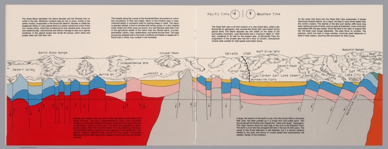
Note
Geologic cross section and map. Covers the Great Basin between Sierra Nevada and the Rockies. Showing the earth's crust from the Carson Sink to the Great Salt Lake. Relief shown pictorially. Includes time zone clocks, showing Pacific standard time and Mountain standard time. Includes descriptive text.
Author
Raymo, Chet
Full Title
(Utah, Wayoming). (to accompany) A geologic and topographic profile of the United States along interstate 80 : by Chet Raymo. 1982. Printed by Hubbard, Northbrook, IL.
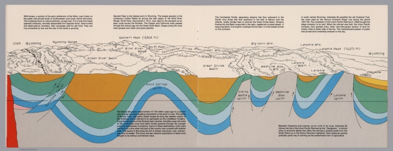
List No
13323.008
Note
Geologic cross section and map of Utah to Wyoming. Covers the area southwestern and south central Wyoming, showing the earth's crust, drainage and mountains. Relief shown pictorially and spot heights. "In the south central Wyoming, Interstate 80 parallels the Overland Trail". Includes descriptive text.
Author
Raymo, Chet
Full Title
(Great Plains, Nebraska). (to accompany) A geologic and topographic profile of the United States along interstate 80 : by Chet Raymo. 1982. Printed by Hubbard, Northbrook, IL.
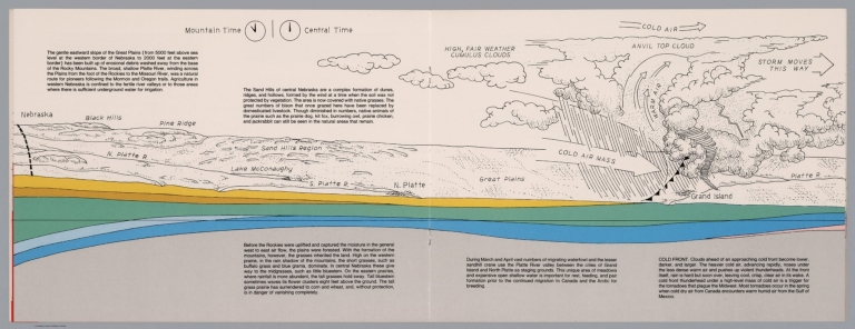
List No
13323.009
Note
Geologic cross section and topographic map of Great Plains, Nebraska. Showing weather system, dunes, ridges and vegetation. Relief shown pictorially. Includes time zone clocks, showing Mountain standard time and Central standard time. Includes descriptive text.
Author
Raymo, Chet
Full Title
(Nebraska, Iowa, Wisconsin). (to accompany) A geologic and topographic profile of the United States along interstate 80 : by Chet Raymo. 1982. Printed by Hubbard, Northbrook, IL.
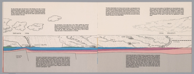
List No
13323.010
Note
Geologic cross section and topographic map. Covers Lincoln, Nebraska to Davenport, Iowa and part of Illinois . Showing weather system, dunes, ridges and major cities. Includes descriptive text.
Author
Raymo, Chet
Full Title
(Illinois, Michigan). (to accompany) A geologic and topographic profile of the United States along interstate 80 : by Chet Raymo. 1982. Printed by Hubbard, Northbrook, IL.
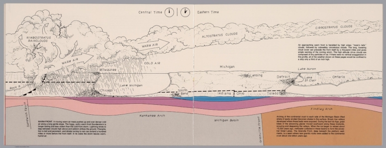
List No
13323.011
Note
Geologic cross section and topographic map. Covers Illinois and Michigan, part of Indiana and Ohio . Showing weather system, dunes, ridges and major cities. Includes time zone clocks, showing Central standard time and Eastern standard time. Includes descriptive text.
Author
Raymo, Chet
Full Title
(New York, Connecticut, Atlantic Ocean). (to accompany) A geologic and topographic profile of the United States along interstate 80 : by Chet Raymo. 1982. Printed by Hubbard, Northbrook, IL.
List No
13323.013
Note
Geologic cross section and topographic map. Covers from Catskill Mts, New York to Atlantic Ocean. Showing weather system, rivers, ridges and major cities. Relief shown by hachures. Includes descriptive text.
Author
Becker, George F.
Full Title
(Covers to) Department Of The Interior, United States Geological Survey, Clarence King Director. Atlas To Accompany The Monograph On The Geology Of The Comstock Lode And The Washoe District By George F. Becker. Washington 1882. Julius Bien & Co. Lith. New York.
List No
1566A
Author
Becker, George F.
Full Title
(Title Page to) Department Of The Interior, United States Geological Survey, Clarence King Director. Atlas To Accompany The Monograph On The Geology Of The Comstock Lode And The Washoe District By George F. Becker. Washington 1882. Julius Bien & Co. Lith. New York.
List No
1566B
Note
An important atlas of the mining activity in the Comstock Lode. With printed color. Bound in brown cloth covered boards with "United States Geological Survey, Clarence King, Director. Atlas To Accompany The Geology Of The Comstock Lode And The Washoe District. Becker" stamped in gilt.
|