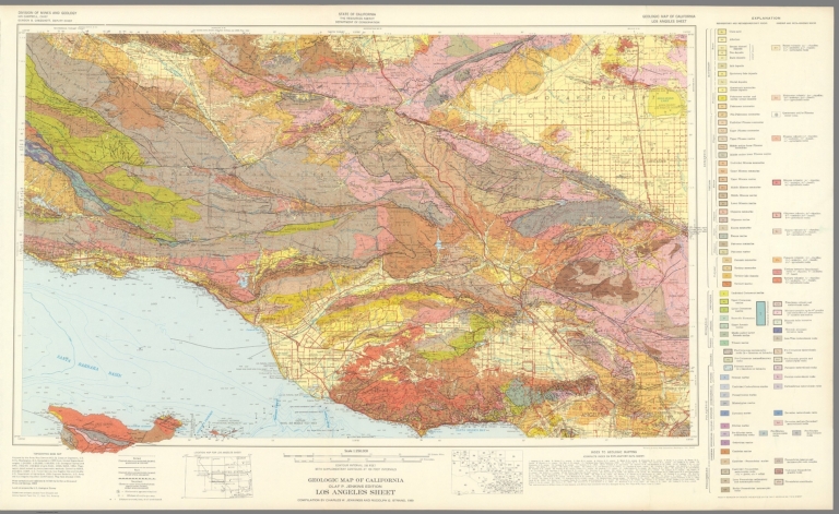
California Division of Mines and Geology Geologic Map of California, Los Angeles ... 1969 6347.037 Related Author
California Division of Mines and Geology
Full Title
Geologic Map of California, Los Angeles Sheet.
List No
6347.037
Note
Full color. Olaf P. Jenkins Edition.
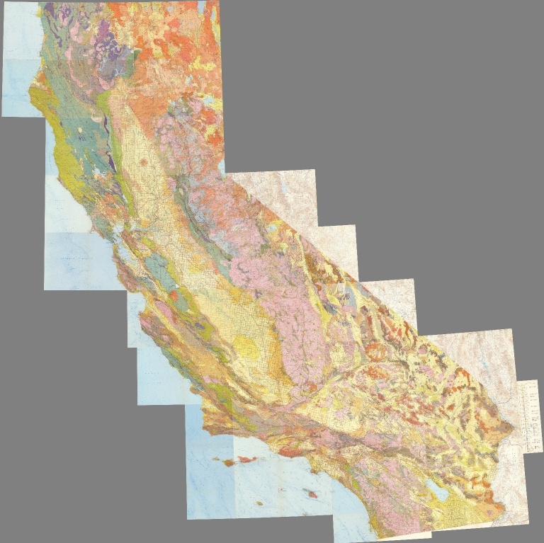
California Division of Mines and Geology Composite Map: Geologic Map of Californi... 1969 6347.114 Related Author
California Division of Mines and Geology
Full Title
(Composite Map) Geologic Map of California.
List No
6347.114
Note
Full color. Olaf P. Jenkins Edition. Individual sheets dated 1958-1969.
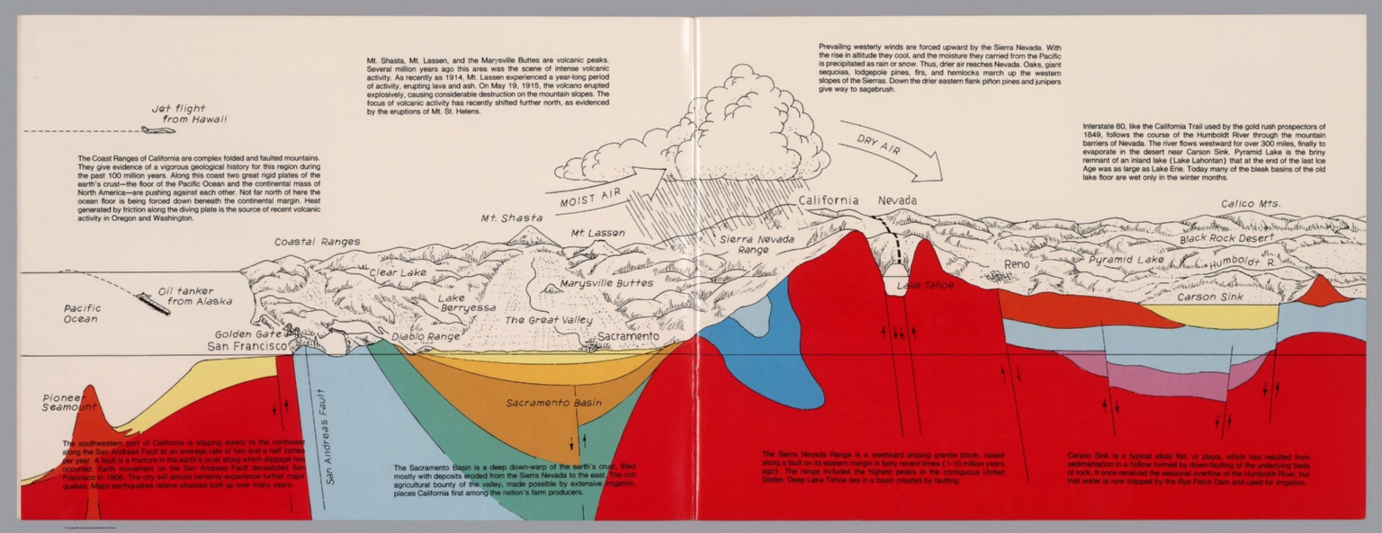
Author
Raymo, Chet
Full Title
(California, Nevada). (to accompany) A geologic and topographic profile of the United States along interstate 80 : by Chet Raymo. 1982. Printed by Hubbard, Northbrook, IL.
List No
13323.006
Note
Geologic cross section and map. Covers the area from Pacific Ocean and San Francisco to Carson Sink, showing the volcanic peaks, fault zone, weather system, lakes, drainage, cities and mountains. Includes descriptive text.
Author
Raymo, Chet
Full Title
(Composite). A geologic and topographic profile of the United States along interstate 80 : by Chet Raymo. 1982. Printed by Hubbard, Northbrook, IL.
List No
13323.014
Note
Composite of 8 sheets of geologic cross section and topographic map. Covers the route along Interstate 80 from San Francisco to New York City.
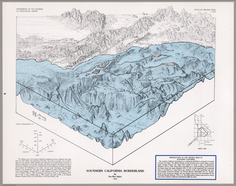
Author
[U.S. Geological Survey, Alpha, Tau Rho]
Full Title
Southern California Borderland.
List No
6353.087
Author
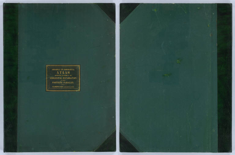
King, Clarence
Full Title
(Covers to) Engineer Department U.S.A. Geological and Topographical Atlas Accompanying the Report of the Geological Exploration of the Fortieth Parallel Made by the Authority of the Honorable Secretary of War under the direction of Brig. and Brvt. Major General A.A. Humphreys, Chief of Engineers U.S.A. by Clarence King, U.S. Geologist in Charge, 1876. Julius Bien Lith.
List No
0408A
Author
King, Clarence
Full Title
(Title Page to) Engineer Department U.S.A. Geological and Topographical Atlas Accompanying the Report of the Geological Exploration of the Fortieth Parallel Made by the Authority of the Honorable Secretary of War under the direction of Brig. and Brvt. Major General A.A. Humphreys, Chief of Engineers U.S.A. by Clarence King, U.S. Geologist in Charge, 1876. Julius Bien Lith.
List No
0408B
Note
Magnificent, huge atlas showing the area of the 40th Parallel Survey in topographical and geological maps. Wheat notes: "These are pioneer survey maps, and as such are most interesting. Mapping the West in so broad a cross-section had never before been attempted, a portent of things to come." King, at the age of 25, was made Geologist-in-charge of the Survey in 1867. He was formally ordered "to examine and describe the geological structure, geographical condition and natural resources of a belt of country extending from the 120th meridian eastward to the 105th meridian, along the 40th parallel of latitude with sufficient expansion north and south to include the lines of 'Central' and 'Union Pacific' railroads..." (Wheat). The topographical sheets depict features by brush shading rather than hachuring. In original binding -rare. Bound in green half leather with a label on the front, "Geological and Topographical Atlas Accompanying the Report of the Geological Exploration of the Fortieth Parallel. Clarence King, Geologist in Charge."
Author
King, Clarence
Full Title
(Index Page to) Engineer Department U.S.A. Geological and Topographical Atlas Accompanying the Report of the Geological Exploration of the Fortieth Parallel Made by the Authority of the Honorable Secretary of War under the direction of Brig. and Brvt. Major General A.A. Humphreys, Chief of Engineers U.S.A. by Clarence King, U.S. Geologist in Charge, 1876. Julius Bien Lith.
List No
0408C
Note
Index page includes the list of maps and a legend naming the mapmakers and the basis by which the maps were made.
Author
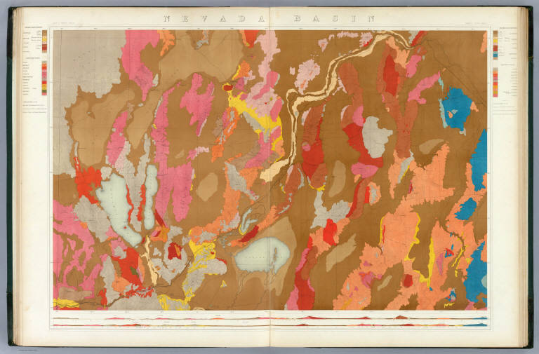
King, Clarence
Full Title
Nevada Basin. Map V. (Geological)
List No
0408.006
Note
Map in full color with the legends on either side of the maps. Map extends from Argenta, Nevada to the west of Pyramid Lake (Lake Tahoe) in California. Below the map are two geologic cross sections.
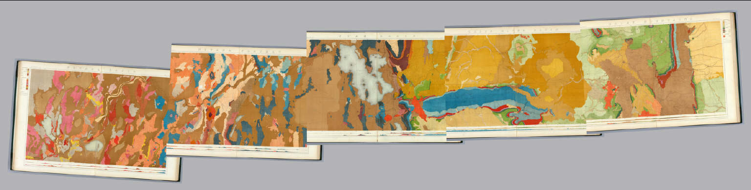
Author
King, Clarence
Full Title
(Composite of) Geological Maps I-V, 40th Parallel Survey.
List No
0408.007
Note
Maps in full color with the legends on either side of the maps.
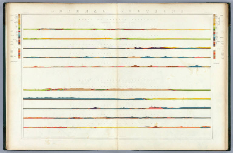
Author
King, Clarence
Full Title
General Sections.
List No
0408.008
Note
In full color. Ten sections shown with the legends on either side of the cross sections.
Author
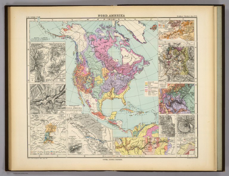
Berghaus, Hermann
Full Title
Nord-Amerika. Ubersicht von Nord-Amerika. (with) Virginia-Silber-Minen. (with) Das Yosemite-Thal. (with) Landenge von Tehuantepec n. J.C. Spear 1871. (with) Landenge von Nicaragua. (with) Die Krater des Turrialba. (with) Landenge von Panama. (with) Seeboden der New-York-Bay. (with) Popocatepetl. (with) Citlaltepetl. (with) Canons des Colorado. (with) Yellowstone-National-Park. (with) Reykjanes und Geyser nach Th. Thoroddsen. Entw. v. Herm. Berghaus 1886, Ausg. 1887. Nebenkarten gez. v. M. Risch. Gotha: Justus Perthes (1892)
List No
1578.012
Note
Lithographed geologic map, color with 12 inset maps. Relief shown by spot heights. Some inset maps are topographic maps showing relief by hachures and spot heights.
Author
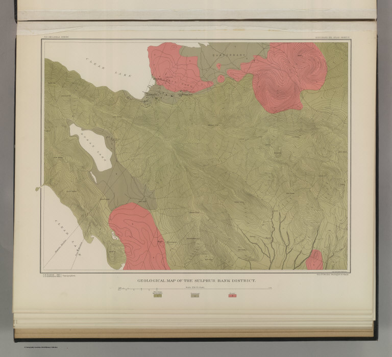
Becker, George F.
Full Title
Geological Map of the Sulphur Bank District. U.S. Geological Survey. Monograph XIII, Atlas Sheet IV. S.H. Bodfish 1882, J.D. Hoffman 1884, Topographers. Giles Litho. & Liberty Printing Co. Geo. F. Becker, Geologist in charge.
List No
4580.002
Note
Shows in color three classes of rock. Relief shown by 20-foot contour lines. Shows mines, streams, and settlements.
Author
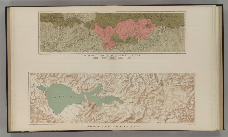
Becker, George F.
Full Title
Geological Map of the Knoxville District. U.S. Geological Survey. Monograph XIII, Atlas Sheet V. Topography by J.D. Hoffman 1883. Geo. F. Becker, Geologist in charge. Topographical Map of the Region of Clear Lake. Compiled by C.F. Hoffmann. Geo. F. Becker, Geologist in charge.
List No
4580.003
Note
Two maps on one sheet. Knoxville District map relief shown with 25-foot contours. Shows in color five classes of rock. Longitude and latitude shown. Scale 1:15,000. Clear Lake Region map shows topography with shaded relief, streams, mines, settlements, and roads. Scale 1:95,000. Outlines of Sulphur Bank District and Knoxville District shown.
Author
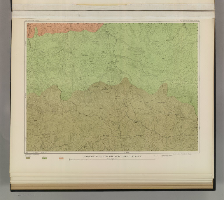
Becker, George F.
Full Title
Geological Map of the New Idria District. U.S. Geological Survey. Monograph XIII, Atlas Sheet VI. J.D. Hoffman, Topographer. Giles Litho. & Liberty Printing Co. N.Y. Geo. F. Becker, Geologist in charge.
List No
4580.004
Note
Shows in color three classes of rock. Relief shown by 40-foot contour lines. Shows streams, settlements, mines, trails, and roads.
Author
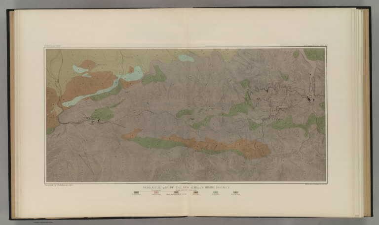
Becker, George F.
Full Title
Geological Map of the New Almaden Mining District. U.S. Geological Survey. Monograph XIII, Atlas Sheet VII. Topography by S.W. Bodfish and others. Giles Litho. & Liberty Printing Co. N.Y. Geo. F. Becker, Geologist in charge.
List No
4580.005
Note
Shows in color six classes of rock. Relief shown by 20-foot contour lines. Shows streams, settlements, mines, and roads.
Author
Becker, George F.
Full Title
Ore-Bodies and Topography of Mine-Hill, New Almaden. U.S. Geological Survey. Monograph XIII, Atlas Sheet VIII. Compiled by F. Reade 1885. Giles Litho. & Liberty Printing Co. N.Y. Geo. F. Becker, Geologist in charge.
List No
4580.006
Note
Shows in topography with 10-foot contours, ore bodies with cross-hatching, mine dumps with hachures, +streams, roads, tramways, tunnels and shafts.
Author
Becker, George F.
Full Title
Plan of the New Almaden Mine. U.S. Geological Survey. Monograph XIII, Atlas Sheet IX. Compiled by F. Reade 1885. Giles Litho. & Liberty Printing Co. N.Y. Geo. F. Becker, Geologist in charge.
List No
4580.007
Note
Shows depths, tunnels, drifts, galleries, and shafts in brilliant color.
Author
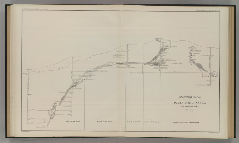
Becker, George F.
Full Title
Longitudinal Section of the South Ore Channel. New Almaden Mine. U.S. Geological Survey. Monograph XIII, Atlas Sheet X. Compiled by F. Reade 1885. Giles Litho. & Liberty Printing Co. N.Y. Geo. F. Becker, Geologist in charge.
List No
4580.008
Note
Shows depths, tunnels, drifts, galleries, and shafts.
Author
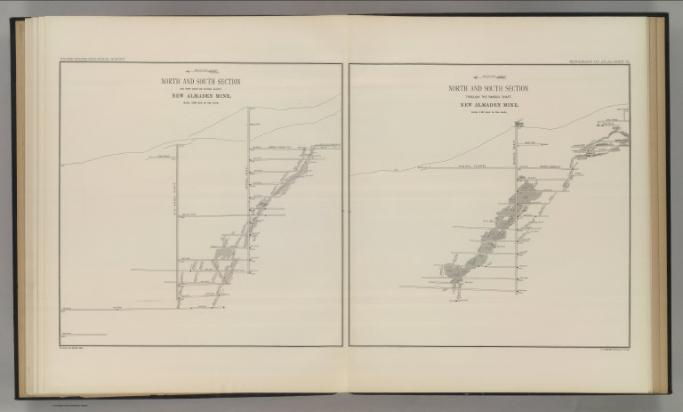
Becker, George F.
Full Title
North and South Section , 550 Feet West of Randol Shaft, New Almaden Mine. North and South Section through the Randol Shaft, New Almaden Mine. U.S. Geological Survey. Monograph XIII, Atlas Sheet XI. Compiled by F. Reade 1885. Geo. F. Becker, Geologist in charge.
List No
4580.009
Note
Two vertical sections on one sheet. Shows depths, tunnels, drifts, galleries, and shafts.
Author
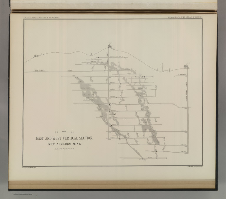
Becker, George F.
Full Title
East and West Vertical Section, New Almaden Mine. U.S. Geological Survey. Monograph XIII, Atlas Sheet XII. Compiled by F. Reade 1885. Geo. F. Becker, Geologist in charge.
List No
4580.010
Note
Shows depths, tunnels, drifts, galleries, and shafts.
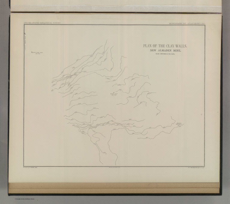
Author
Becker, George F.
Full Title
Plan of the Clay Walls, New Almaden Mine. U.S. Geological Survey. Monograph XIII, Atlas Sheet XIII. Compiled by F. Reade 1885. Giles Litho. & Liberty Printing Co. N.Y. Geo. F. Becker, Geologist in charge.
List No
4580.011
Note
Shows alignments of clay walls.
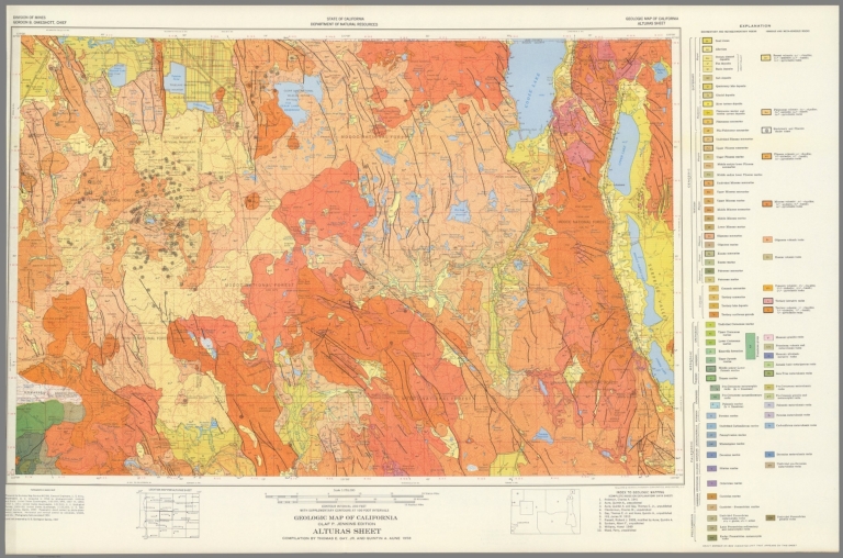
California Division of Mines and Geology Geologic Map of California, Alturas Shee... 1958 6347.009 Related Author
California Division of Mines and Geology
Full Title
Geologic Map of California, Alturas Sheet.
List No
6347.009
Note
Full color.
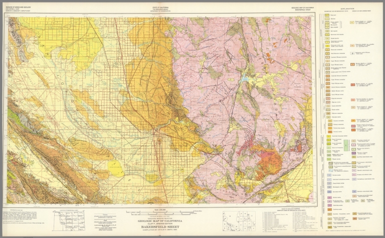
California Division of Mines and Geology Geologic Map of California, Bakersfield ... 1964 6347.013 Related Author
California Division of Mines and Geology
Full Title
Geologic Map of California, Bakersfield Sheet.
List No
6347.013
Note
Full color.
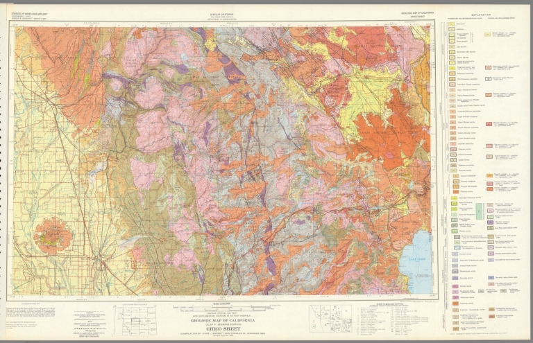
California Division of Mines and Geology Geologic Map of California, Chico Sheet. 1962 6347.017 Related Author
California Division of Mines and Geology
Full Title
Geologic Map of California, Chico Sheet.
List No
6347.017
Note
Full color.
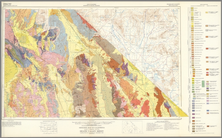
California Division of Mines and Geology Geologic Map of California, Death Valley... 1958 6347.021 Related Author
California Division of Mines and Geology
Full Title
Geologic Map of California, Death Valley Sheet.
List No
6347.021
Note
Full color. Olaf P. Jenkins Edition.
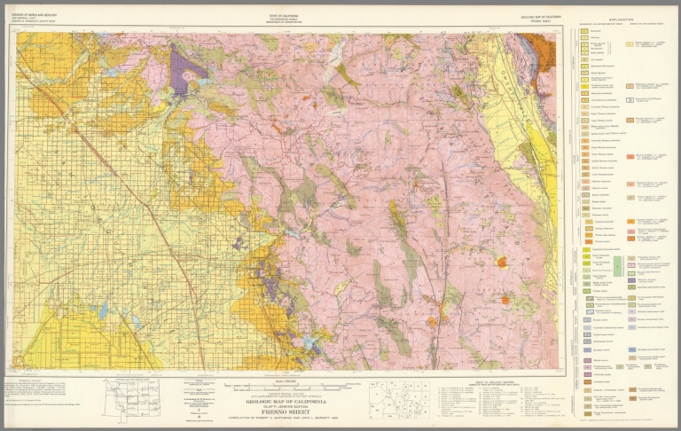
California Division of Mines and Geology Geologic Map of California, Fresno Sheet... 1965 6347.025 Related Author
California Division of Mines and Geology
Full Title
Geologic Map of California, Fresno Sheet.
List No
6347.025
Note
Full color. Olaf P. Jenkins Edition.
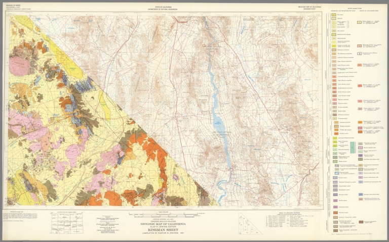
California Division of Mines and Geology Geologic Map of California, Kingman Shee... 1961 6347.029 Related Author
California Division of Mines and Geology
Full Title
Geologic Map of California, Kingman Sheet.
List No
6347.029
Note
Full color. Olaf P. Jenkins Edition.
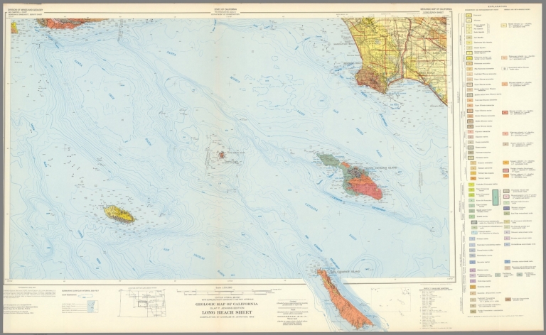
California Division of Mines and Geology Geologic Map of California, Long Beach S... 1962 6347.033 Related Author
California Division of Mines and Geology
Full Title
Geologic Map of California, Long Beach Sheet.
List No
6347.033
Note
Full color. Olaf P. Jenkins Edition.
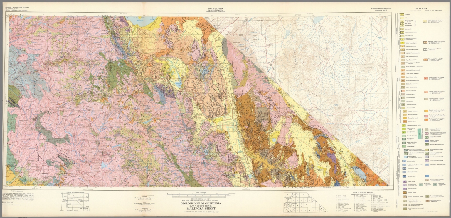
California Division of Mines and Geology Geologic Map of California, Mariposa She... 1967 6347.041 Related Author
California Division of Mines and Geology
Full Title
Geologic Map of California, Mariposa Sheet.
List No
6347.041
Note
Full color. Olaf P. Jenkins Edition.
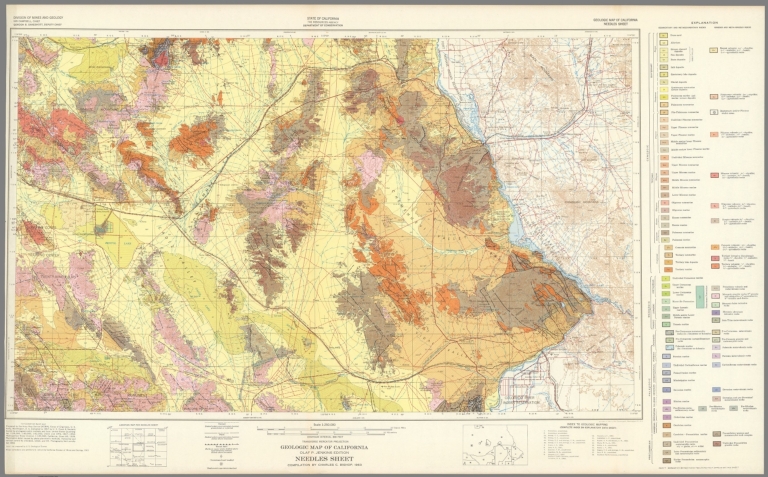
California Division of Mines and Geology Geologic Map of California, Needles Shee... 1963 6347.045 Related Author
California Division of Mines and Geology
Full Title
Geologic Map of California, Needles Sheet.
List No
6347.045
Note
Full color. Olaf P. Jenkins Edition.
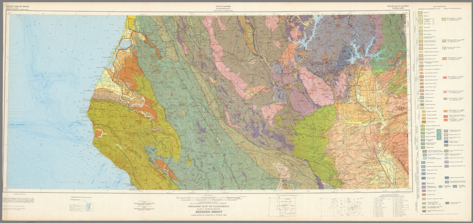
California Division of Mines and Geology Geologic Map of California, Redding Shee... 1962 6347.049 Related Author
California Division of Mines and Geology
Full Title
Geologic Map of California, Redding Sheet.
List No
6347.049
Note
Full color. Olaf P. Jenkins Edition.
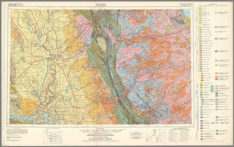
California Division of Mines and Geology Geologic Map of California, Sacramento S... 1965 6347.053 Related Author
California Division of Mines and Geology
Full Title
Geologic Map of California, Sacramento Sheet.
List No
6347.053
Note
Full color. Olaf P. Jenkins Edition.
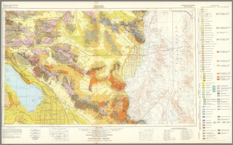
California Division of Mines and Geology Geologic Map of California, Salton Sea S... 1967 6347.057 Related Author
California Division of Mines and Geology
Full Title
Geologic Map of California, Salton Sea Sheet.
List No
6347.057
Note
Full color. Olaf P. Jenkins Edition.
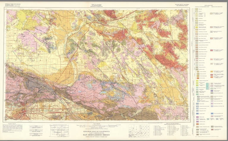
California Division of Mines and Geology Geologic Map of California, San Bernadin... 1967 6347.061 Related Author
California Division of Mines and Geology
Full Title
Geologic Map of California, San Bernadino Sheet.
List No
6347.061
Note
Full color. Olaf P. Jenkins Edition.
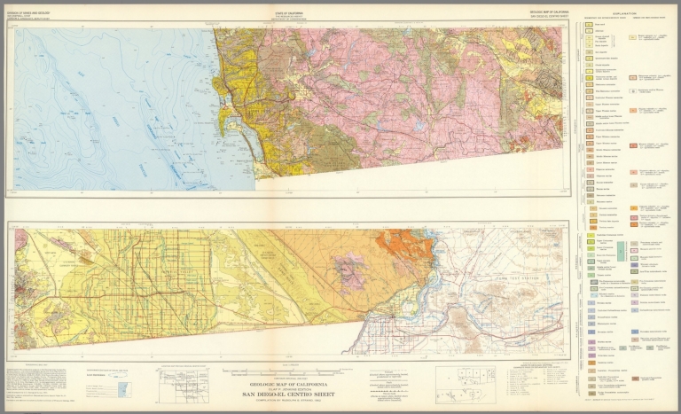
California Division of Mines and Geology Geologic Map of California, San Diego - ... 1962 6347.065 Related Author
California Division of Mines and Geology
Full Title
Geologic Map of California, San Diego - El Centro Sheet.
List No
6347.065
Note
Full color. Olaf P. Jenkins Edition.
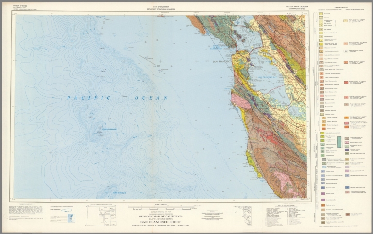
California Division of Mines and Geology Geologic Map of California, San Francisc... 1961 6347.069 Related Author
California Division of Mines and Geology
Full Title
Geologic Map of California, San Francisco Sheet.
List No
6347.069
Note
Full color. Olaf P. Jenkins Edition.
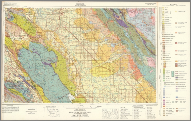
California Division of Mines and Geology Geologic Map of California, San Jose She... 1966 6347.073 Related Author
California Division of Mines and Geology
Full Title
Geologic Map of California, San Jose Sheet.
List No
6347.073
Note
Full color. Olaf P. Jenkins Edition.
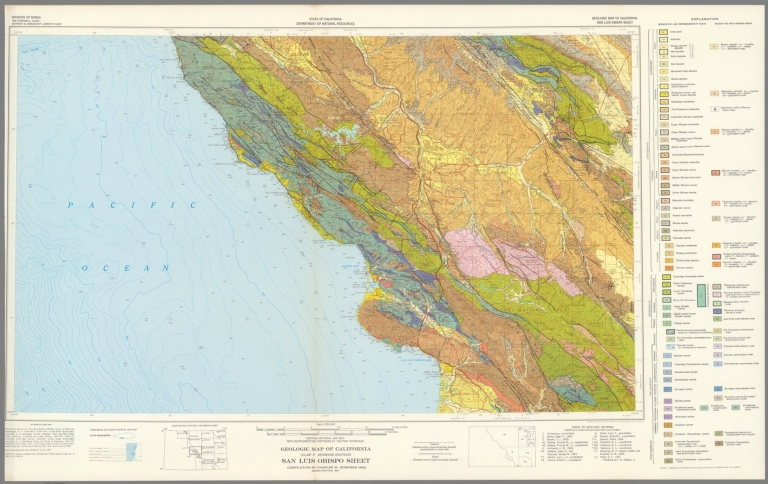
California Division of Mines and Geology Geologic Map of California, San Luis Obi... 1958 6347.077 Related Author
California Division of Mines and Geology
Full Title
Geologic Map of California, San Luis Obisbo Sheet.
List No
6347.077
Note
Full color. Olaf P. Jenkins Edition.
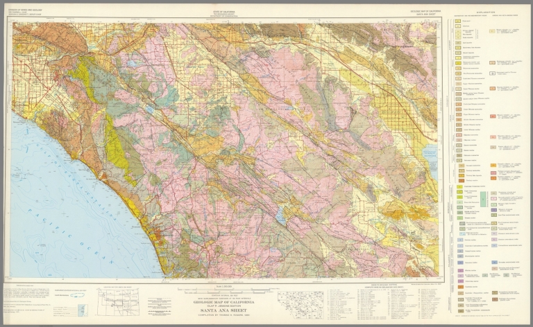
California Division of Mines and Geology Geologic Map of California, Santa Ana Sh... 1965 6347.081 Related Author
California Division of Mines and Geology
Full Title
Geologic Map of California, Santa Ana Sheet.
List No
6347.081
Note
Full color. Olaf P. Jenkins Edition.
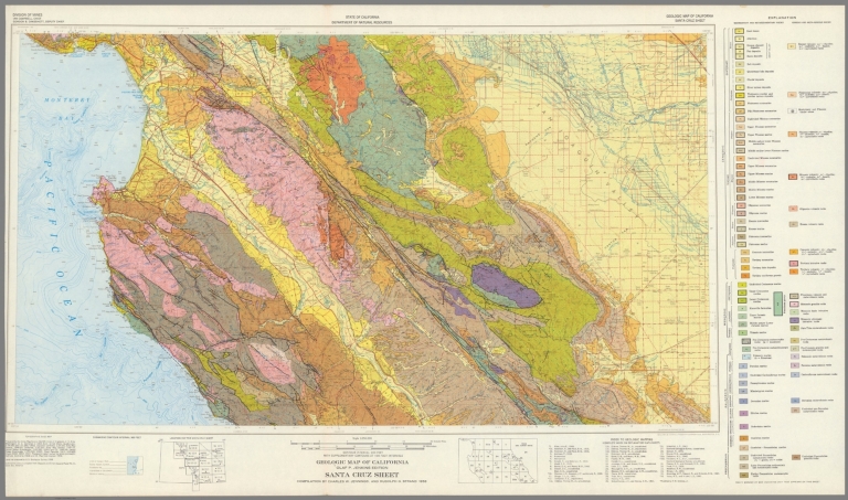
California Division of Mines and Geology Geologic Map of California, Santa Cruz S... 1958 6347.085 Related Author
California Division of Mines and Geology
Full Title
Geologic Map of California, Santa Cruz Sheet.
List No
6347.085
Note
Full color. Olaf P. Jenkins Edition.
California Division of Mines and Geology Geologic Map of California, Santa Maria ... 1959 6347.089 Related Author
California Division of Mines and Geology
Full Title
Geologic Map of California, Santa Maria Sheet.
List No
6347.089
Note
Full color. Olaf P. Jenkins Edition.
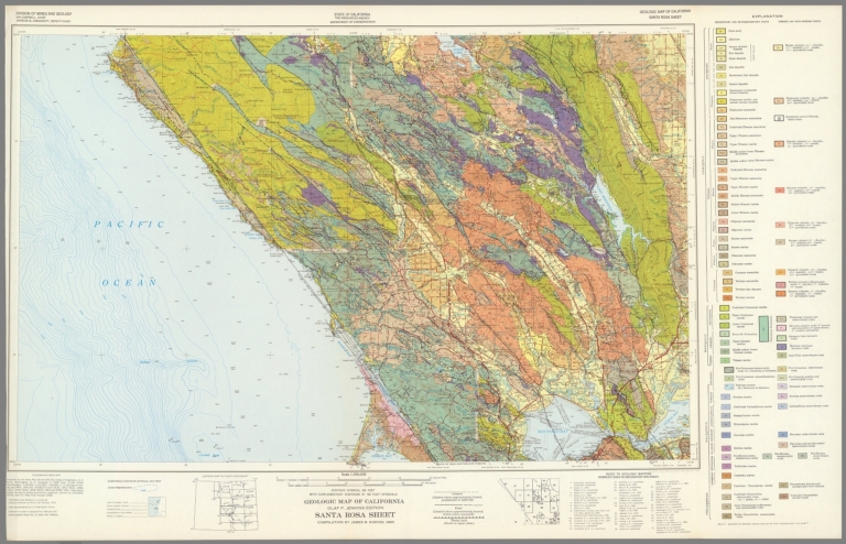
California Division of Mines and Geology Geologic Map of California, Santa Rosa S... 1963 6347.093 Related Author
California Division of Mines and Geology
Full Title
Geologic Map of California, Santa Rosa Sheet.
List No
6347.093
Note
Full color. Olaf P. Jenkins Edition.
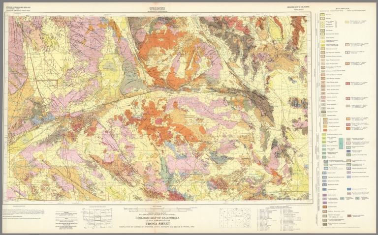
California Division of Mines and Geology Geologic Map of California, Trona Sheet. 1962 6347.097 Related Author
California Division of Mines and Geology
Full Title
Geologic Map of California, Trona Sheet.
List No
6347.097
Note
Full color. Olaf P. Jenkins Edition.
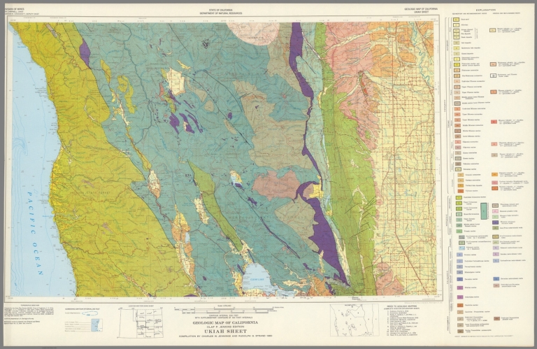
California Division of Mines and Geology Geologic Map of California, Ukiah Sheet. 1960 6347.101 Related Author
California Division of Mines and Geology
Full Title
Geologic Map of California, Ukiah Sheet.
List No
6347.101
Note
Full color. Olaf P. Jenkins Edition.
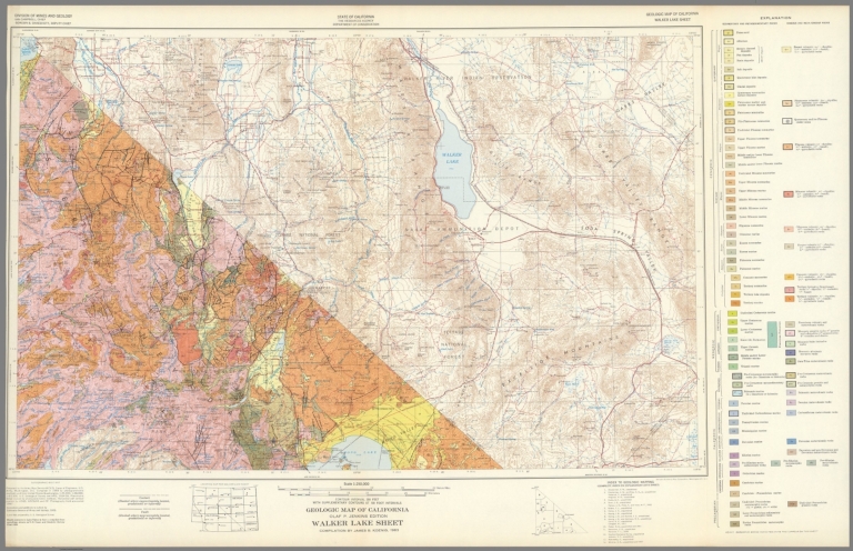
California Division of Mines and Geology Geologic Map of California, Walker Lake ... 1963 6347.105 Related Author
California Division of Mines and Geology
Full Title
Geologic Map of California, Walker Lake Sheet.
List No
6347.105
Note
Full color. Olaf P. Jenkins Edition.
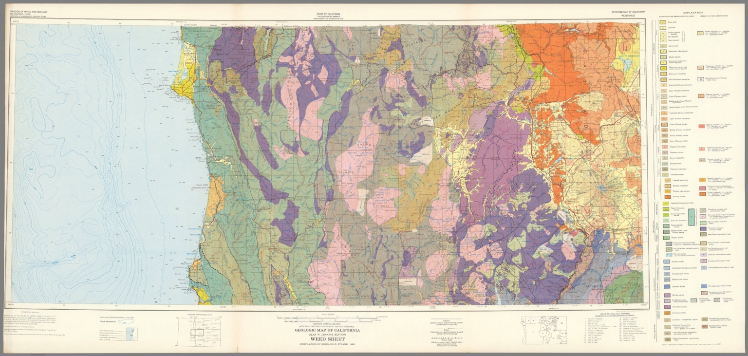
California Division of Mines and Geology Geologic Map of California, Weed Sheet. 1963 6347.109 Related Author
California Division of Mines and Geology
Full Title
Geologic Map of California, Weed Sheet.
List No
6347.109
Note
Full color. Olaf P. Jenkins Edition.
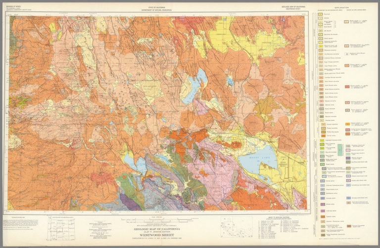
California Division of Mines and Geology Geologic Map of California, Westwood She... 1960 6347.113 Related Author
California Division of Mines and Geology
Full Title
Geologic Map of California, Westwood Sheet.
List No
6347.113
Note
Full color. Olaf P. Jenkins Edition.
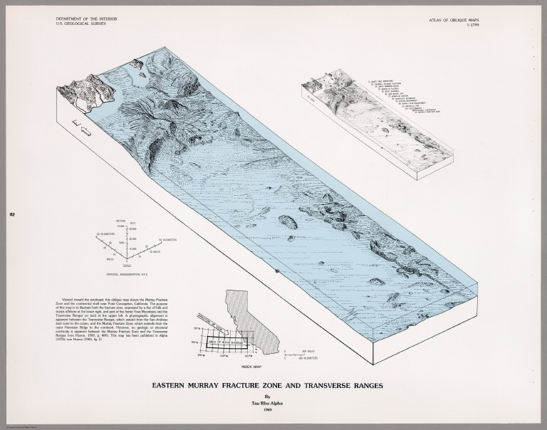
U.S. Geological Survey; Alpha, Tau Rho Eastern Murray Fracture Zone and Transve... 1969 6353.082 Related Author
[U.S. Geological Survey, Alpha, Tau Rho]
Full Title
Eastern Murray Fracture Zone and Transverse Ranges.
List No
6353.082
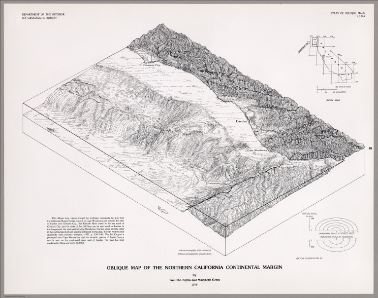
U.S. Geological Survey; Alpha, Tau Rho; ... Oblique Map of the Northern California C... 1979 6353.083 Related Author
[U.S. Geological Survey, Alpha, Tau Rho, Gerin, Marybeth]
Full Title
Oblique Map of the Northern California Continental Margin.
List No
6353.083
|