|
REFINE
Browse All : Geology and Book Map from 1852
1-9 of 9
Author
Owen, David Dale
Full Title
Map showing the positions of the Bad Lands or Mauvaises Terres of Nebraska, from a draft by John Evens of the U.S. Geological Survey. (to accompany) Illustrations to the Geological Report of Wisconsin, Iowa, and Minnesota. (with) Report of a Geological Survey of Wisconsin, Iowa and Minnesota ... 1852.
List No
0690.032
Note
Uncolored map. Shows rivers, forts, mountains. Relief shown by hachures.
Author
Owen, David Dale
Full Title
Geological map of parts of Minnesota and Wisconsin. Designed to show portions of the Rock formations now concealed by drift. By J.G. Norwood. Drawn by J. Chappell smith. (to accompany) Illustrations to the Geological Report of Wisconsin, Iowa, and Minnesota. (with) Report of a Geological Survey of Wisconsin, Iowa and Minnesota ... 1852.
List No
0690.033
Note
Hand color map. References indicated on the maps are Limestones of Cedar Valley, Upper and Lower Magnesium Limestone, Lowest Sandstones, Metamorphic Schists, and Granite & Sienitic Rocks. Prime meridian is Washington.
Author
Owen, David Dale
Full Title
Geological map: Coast view and section of Pigeon Point. By Richard Owen. Engd. on steel by W.H. Dougal, Washington, D.C. Cost section from the West end of Grand Portage Bay to the extremity of Pigeon Point in direction North of East. By Richard Owen. (on upper right margin) Pl.N. (to accompany) Illustrations to the Geological Report of Wisconsin, Iowa, and Minnesota. (with) Report of a Geological Survey of Wisconsin, Iowa and Minnesota ... 1852.
List No
0690.035
Note
Hand color geologic map and cross section, folded to 31x21 cm., with uncolored view of the coast folded to 31x20 cm. On upper right margin Pl.N.
Author
Owen, David Dale
Full Title
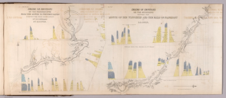
Sec. No. 3 S. Series of sections on the Wisconsin River from the mouth to Whitneys Rapids; Constructed from observations of B.F. Shumard, by D.D. Owen. Sec. No. 1. Series of sections on the Mississippi between the mouth of the Wisconsin river and the Falls of St. Anthony, by D.D. Owen. Engd. on steel by W.H. Dougal, Washington, D.C. (to accompany) Illustrations to the Geological Report of Wisconsin, Iowa, and Minnesota. (with) Report of a Geological Survey of Wisconsin, Iowa and Minnesota ... 1852.
List No
0690.040
Note
Maps and cross sections, folded to 31x21 cm. Relief shown by hachures and spot heights.
Author
Owen, David Dale
Full Title
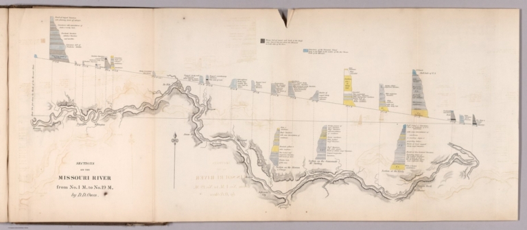
Sections on the Missouri River, from No.1 M, to No. 19 M, by D.D. Owen. (to accompany) Illustrations to the Geological Report of Wisconsin, Iowa, and Minnesota. (with) Report of a Geological Survey of Wisconsin, Iowa and Minnesota ... 1852.
List No
0690.041
Note
Map and cross sections, folded to 31x21 cm. Shows settlements and forts. Relief shown by hachures. Include note and explanations.
Author
Owen, David Dale
Full Title
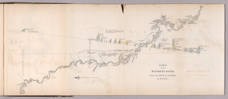
Sections on the Missouri River, from No. 20 M, to No. 40 M, by D.D. Owen. (to accompany) Illustrations to the Geological Report of Wisconsin, Iowa, and Minnesota. (with) Report of a Geological Survey of Wisconsin, Iowa and Minnesota ... 1852.
List No
0690.042
Note
Map and colored cross sections, folded to 31x21 cm. Relief shown by hachures and spot heights. Include explanations.
Author
Owen, David Dale
Full Title
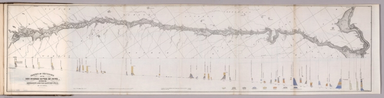
Series of sections on the Des Moines River in Iowa, between the Mississippi and the Racoon Fork, by D.D. Owen. Acherman Lith. 379 Broadway, N.Y. (to accompany) Illustrations to the Geological Report of Wisconsin, Iowa, and Minnesota. (with) Report of a Geological Survey of Wisconsin, Iowa and Minnesota ... 1852.
List No
0690.043
Note
Map and colored cross sections, folded to 31x21 cm. Shows settlements and forts. Geologic cross-sections shown in color. Relief shown by hachures. Include explanations.
Author
Owen, David Dale
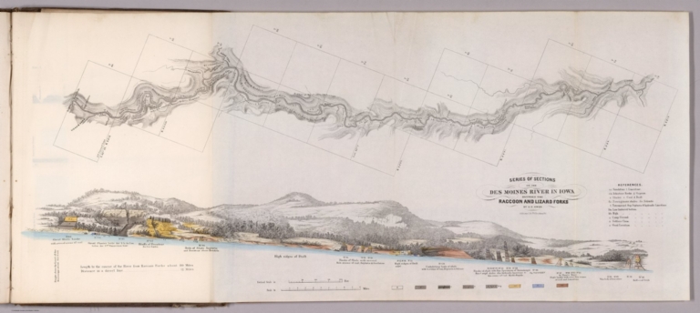
Full Title
Series of sections on the Des Moines River in Iowa, between the Racoon and Lizard Forks, by D.D. Owen. Acherman Lith. 379 Broadway, N.Y. (to accompany) Illustrations to the Geological Report of Wisconsin, Iowa, and Minnesota. (with) Report of a Geological Survey of Wisconsin, Iowa and Minnesota ... 1852.
List No
0690.044
Note
Map and color cross sections, folded to 31x21 cm. Shows settlements and forts. Geologic cross-sections shown in color. Relief shown by hachures. Include reference and explanations.
Author
Owen, David Dale
Full Title
Geological map of Wisconsin, Iowa and Minnesota : exhibiting, also, the extension of the Iowa coal-field into Missouri, and its relation to the Illinois coal-field / constructed from observations by the United States Geological Corps, under instructions from the Secretary of the Treasury, by David Dale Owen ; middle, northern and northeastern Minnesota by J.G. Norwood ; the greater part of the southern shore of Lake Superior, in Wisconsin, by Col. Chas. Whittlesey. 1851. Engraved by W. Smith. Washn. (to accompany) Illustrations to the Geological Report of Wisconsin, Iowa, and Minnesota. (with) Report of a Geological Survey of Wisconsin, Iowa and Minnesota ... 1852. Inset: Geological map of the north shore of Lake Superior : on the scale of the original m.s. map. Scale [ca. 1:600,000].
List No
0690.052
Note
Hand colored geological map. Shows geological formations via hand coloring. It also shows the Iowa coal-field extending into northern Missouri and part of the Illinois coal-field. There is excellent detail of watershed and lakes throughout. Includes Table showing geological formation by color.
1-9 of 9
|