|
REFINE
Browse All : Geology and Atlas Map from 1967
1-7 of 7
Author
[Imhof, Eduard, 1895-1986, Eidgenössische Landestopographie, Jäckli, H. (Heinrich), Kempf, Th. (Theo), Amberger, G.]
Full Title
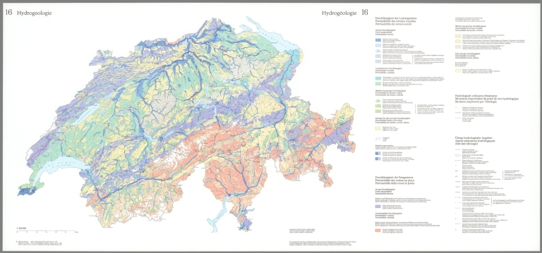
Hydrogeologie = Hydrogéolgoie. Bearbeiter: Heinrich Jäckli und Mitarbeiter ... Kartographische Gestaltung: Redaktionsbüro Atlas der Schwiez, Eidgenössischen Technische Hochschule, Zürich ... © Atlas der Schweiz. Eidg. Landestopographie, Wabern-Bern, 1967 ...
List No
14256.076
Note
Colored water map of Switzerland, numbered 16 within Atlas der Schweiz. On second and third pages of sixteenth (numbered) folio. Title - in German and French - translates to: [Hydrogeology]. Map shows the international border, and the distribution and movement of groundwater in the soil and rocks of the Earth's crust. Includes a scale statement. Map is 45 x 70 cm, on fold-out sheet 51 x 110 cm. Fold-out page Includes legends and explanatory notes. "16" in upper left and center corners. Accompanied by descriptive text on first and fifth pages of folio.
Author
Polish Army Topography Service
Full Title
Geology. Tectonics. Pergamon World Atlas. Pergamon Press, Ltd. & P.W.N. Poland 1967. Sluzba Topograficzna W.P.
List No
0737.020
Note
Two maps. Lands classified by geologic periods. Tectonic features in 33 categories, both continental and oceanic.
Author
Polish Army Topography Service
Full Title
Quaternary. Geomorphology. Pergamon World Atlas. Pergamon Press, Ltd. & P.W.N. Poland 1967. Sluzba Topograficzna W.P.
List No
0737.021
Note
Two maps. Includes maximum extent of ice sheets and mountain glaciation. Shows various types of deposits such as glacial, fluvial, marine, and colluvial. Geomorphology map provides landforms such as loess, sedimentary plateaus, volcanic rocks, alpine mountains, etc.
Author
Geological Survey (U.S.)
Full Title
Geologic map : Scale 1:250,000 -- Progress of 1:250,000-scale geologic mapping operations, June 1967 / adapted from U. S. Geological Survey, Geological Survey research, 1967, chap. A, U. S. Geological Survey Professional Paper 575-A, Washington, U. S. Govt. Print. Off., 1967, p. A63.
List No
14359.243
Note
Two geologic maps representing the United States, featuring the progress of 1:250,000-scale geologic mapping operations, as of June 1967. Maps show the geographic locations of mapping status, such as fieldwork planned, begun and completed, as well as the locations of mapping done by state geological surveys and the U. S. Geological Survey. Maps also show political boundaries, topography, geology, bodies of water, drainage, coastlines and islands. Relief shown with contour lines. Map of the United States includes a legend, as well as a bar scale and scale statement. Map of the United States (presented with Albers Equal Area Projection) provides indexes to other maps with further detail. Map of the United States has two inset maps: Principal islands of Hawaii -- Hawaii. Colored lithograph. Together, maps are 42 x 31 cm, on sheet 49 x 35 cm. Accompanied by descriptive text here, as well as on page 303. Maps appear in Special subject maps section, subsection Mapping and charting.
Author
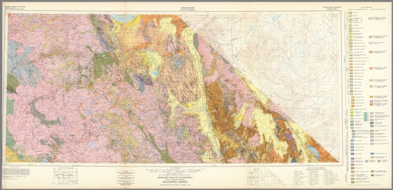
California Division of Mines and Geology
Full Title
Geologic Map of California, Mariposa Sheet.
List No
6347.041
Note
Full color. Olaf P. Jenkins Edition.
Author
California Division of Mines and Geology
Full Title
Geologic Map of California, Salton Sea Sheet.
List No
6347.057
Note
Full color. Olaf P. Jenkins Edition.
Author
California Division of Mines and Geology
Full Title
Geologic Map of California, San Bernadino Sheet.
List No
6347.061
Note
Full color. Olaf P. Jenkins Edition.
1-7 of 7
|