|
REFINE
Browse All : Geology and Atlas Map of World
1-45 of 45
Author
[Sydow, Emil von., 1812-1873, Wagner, Hermann, 1840-1929]
Full Title
Tektonik und Geologie der Erde. Gotha : Justus Perthes. Sydow-Wagners method. Schul-Atlas XXIII.
List No
13559.023
Note
Tectonic map of the world, with 4 insets at the scale of 1:100,000,000. Including: North America; South America; Africa; Australia and Indonesia. Showing principal tectonic regions. Includes color coded tectonic classification for continental and oceanic.
Author
[Sydow, Emil von., 1812-1873, Wagner, Hermann, 1840-1929]
Full Title
Tektonik und Geologie der Erde. Gotha : Justus Perthes. Sydow-Wagners method. Schul-Atlas. XXI.
List No
13557.024
Note
Tectonic map of the world, with 4 insets at the scale of 1:100,000,000: North America; South America; Africa; Australia and Indonesia. Showing principal tectonic regions. Includes color coded tectonic classification for continental and oceanic.
Author
[Československá akademie věd., Klíma, Jan]
Full Title
Země tektonika pudy. Československý vojenský atlas̊.
List No
13684.025
Note
Two maps of the world on 1 sheet. Including tectonic map, with table of 16 tectonic features. And Soil map, with table of soil type.
Author
[Johnston, Alexander Keith, 1804-1871, Boue, Ami]
Full Title
The Geological Structure of the Globe according to Ami Boue. (insets) Elie de Beaumont's Chart of the Elevations of Mountains. Illustrations of the Synchronism if Parallel Chains. The Principal Mountains of the World.
List No
12509.011
Author
[Berghaus, Heinrich, Berghaus, Hermann, Schmidt, C., Risch, M.]
Full Title
Tieflander. Entw. v. Herm. Berghaus 1883, Ausg. 1887. Gez. v. C. Schmidt u. M. Risch. Gotha: Justus Perthes. (On upper margin) I. Abt. Geologie No. II. Berghaus' physikal atlas No. 2. (to Accompany) Berghaus' Physikalischer Atlas. (Begrundet 1836 durch Heinrich Berghaus) ... Gotha: Justus Perthes. 1892.
List No
4391.013
Note
14 color lithograph maps with insets on 1 sheet. Includes: Die Heutigen Niederlande, with insets: Niederlande in 1. Jahrhundert -- Niederlande in X. Jahrhundert, at scale of 1: 6,000,000. Fen District -- El-Ghor oder das Jordan Thal -- Kaspisches Tiefland und Manytsch Niederrung -- Natron-Seen -- El Fajum -- Nordrand der Libyschen Wuste -- Das Todte Thal -- Colorado-Wuste -- Nordrand der Algerischen Sahara -- Goban n. Paulistischke -- Sud-Australische Seen -- Tiefland Asale -- Assal-See. Relief shown by contours and spot heights. Depth shown by gradient tints and soundings. Prime meridian is Greenwich.
Author
[Berghaus, Heinrich, Berghaus, Hermann, Schmidt, C., Risch, M.]
Full Title
Thatigkeit des Erdinnern. Vulkane und Strand-veranderungen in Mollweide's flachenrechter Erdansicht. Entw. v. Herm. Berghaus 1885, Ausg. 1888. Gotha: Justus Perthes. (On upper margin) I. Abt. Geologie No. III. Berghaus' physikal atlas No. 3. (to Accompany) Berghaus' Physikalischer Atlas. (Begrundet 1836 durch Heinrich Berghaus) ... Gotha: Justus Perthes. 1892. (8 insets).
List No
4391.014
Note
Color lithograph maps with 8 insets and 1 profile view. Relief shown by contours and spot heights. Depth shown by gradient tints and soundings. Prime meridian is Greenwich. Insets: Jan Mayer, nordlichster Vulkan -- Erdbeben-Gebiete westliche -- Ostliche Erdbeben-Gebiete -- Insel Augustin (Tschernabura) -- Stromboli (Liparische Inseln) thatigster Vulkan -- Santorin (Kykladen) -- Sunda Strasse -- Tengger-Gebirge & Semiru. Includes legend and explanation.
Author
[Berghaus, Heinrich, Berghaus, Hermann]
Full Title
Eisverbreitung, einst und jetzt. Polar Ansicht der Erde in Lambert's flachenrechter Azimuthal-projection. Entw. v. Herm. Berghaus 1884, Ausg. 1886. Gotha: Justus Perthes. (On upper margin) I. Abt. Geologie No. V. Berghaus' physikal atlas No. 5. (to Accompany) Berghaus' Physikalischer Atlas. (Begrundet 1836 durch Heinrich Berghaus) ... Gotha: Justus Perthes. 1892. (7 insets).
List No
4391.016
Note
Color lithograph double hemisphere map with 7 insets. Depth shown by gradient tints, isoline and soundings. Relief shown by hachures. Insets: Der Rhein-Gletscher nach A. Favre -- Der Rhone Gletscher nach A. Falsan -- Seen-Gebiet in Nord-Amerika nach Chamberlin und Wright -- Die Europaischen Alpen -- Iseo-Gletscher nach Stroppani -- Der Loisach- und Inn-Gletscher n. Penck & Bayberger -- Die Sudlichen Alpen (Neu-Seeland) nach J. v. Haast. Includes legend and explanation.
Author
[Berghaus, Heinrich, Berghaus, Hermann, Risch, M., Hess, O., Kogel, F.]
Full Title
Gletscherkarte. Entw. v. Herm. Berghaus 1885, Ausg. 1888. Gez. v. M. Risch. Gest. v. O. Hess, Berge v. F. Kogel. Gotha: Justus Perthes. (On upper margin) I. Abt. Geologie No. VI. Berghaus' physikal atlas No. 6. (to Accompany) Berghaus' Physikalischer Atlas. (Begrundet 1836 durch Heinrich Berghaus) ... Gotha: Justus Perthes. 1892.
List No
4391.017
Note
21 color lithograph maps on 1 sheet. Relief shown by hachures and spot heights. Insets: Inlandeis des Frederickshaab-Glets chers nach J.A.D. Jensen -- Gronlandisches Binnen-Eis -- Justedals Bra -- Jotun Fjeld -- Berner Oberland -- Gletscher des Halbinsel Kenai (Alaska) -- Aus dem sudlichen Gronland n. G. Holm -- Gletscher des Mount Tacoma (nach dem Northern Transcontinental Survey) von Bailey Willis -- Gletscher des Mount Shasta (nach dem U.S. Geological Survey) von J.S. Diller -- Gletscher von Oisans -- Nevado de Chillan nach A. Philippi -- San Rafael Gletscher -- Oetzthaler Gruppe -- Glockner Gruppe -- Ross-Gletscher (Sud-Georgien) -- Gletscher des Adai Choch (Kaukasus) nach M. v. Dechy -- Hohe von Schneegrenzen und Gletscher-Enden -- Gletscher des Kasbek -- Serafschan Gletscher (Turkestan) nach I.W. Muschketow -- Neuseelandische Alpen nach R. v. Lendenfield.
Author
Johnston, Alexander Keith
Full Title
The Distribution of Earthquakes & Volcanoes over the Globe.
List No
0370.019
Note
Includes profiles of mountains, extent of Lisbon tsunami, and extent of historical earthquakes.
Author
[Boue, Ami, 1794-1881, Johnston, Alexander Keith, 1804-1871]
Full Title
The geological structure of the globe according to Ami Boue, with corrections and additions to 1855. By A.K. Johnston, F.R.G.S. Engraved by W. & A.K. Johnston. William Blackwood & Sons, Edinburgh & London, (1856)
List No
0372.001
Note
Hand col. lithographed map. Shows 6 geologic units. Includes an illustration "The principal mountains of the globe arranged according to geographical longitude, with elevations above the level of the sea," and 4 inset maps: Directions of the systems of mountains as they appear at Milford by E. de Beaumont -- Illustrations of the synchronism of parallel chains --(North Pole region) --(Antarctic Regions) "Geology no. 1."
Author
Johnston, Alexander Keith, 1804-1871
Full Title
The phenomena of volcanic action showing the regions visited by earthquakes and the distribution of volcanoes over the globe. With corrections and additions, to 1854, by A.K. Johnston, F.R.S.E. Engraved by W. & A.K. Johnston. William Blackwood & Sons, Edinburgh & London. (1856)
List No
0372.011
Note
Hand col. lithographic map. Relief shown by hachures and spot heights. Insets: Enlarged map of the principal volcanic series of the new world -- Enlarged map of the principal volcanic series of the old world -- Enlarged map of northern India showing the earthquake districts -- Iceland, chiefly according to Krug von Nidda . Scale 1:5,000,000 -- Island of Santorini on an enlarged scale -- Eaheinomauwe, North I. of New Zealand by Leopold von Buch. Scale 1:6,000,000 -- Canary Islands. Scale 1:6,000,000 -- Hawaii Archipelago or Sandwich Islands. Scale 1:6,000,000 -- Greek Islands according to Leopold von Buch. Scale 1:6,000,000 -- Earthquake region of the United States and W.I. islands -- Volcanic district of Lower Italy. Scale 1:6,000,000. Illustrations: Jorullo in Mexico, A. v. Humboldt -- Tankuban Prahu in Java, S. Muller. "Geology no. 10."
Author
Johnston, Alexander Keith, 1804-1871
Full Title
Comparative views of remarkable geological phenomena by A.K. Johnston, F.R.G.S. Engraved by W. & A.K. Johnston. William Blackwood & Sons, Edinburgh & London. (1856)
List No
0372.012
Note
Hand col. lithograph. Relief shown by hachures and spot heights. Contents: Plan of the volcanoes of Pichincha and Antisana surveyed by A. von Humboldt. Scale 1:200,000 -- Plans of the craters of Vesuvius and Etna by H. Abich, 1834. Scale 1:20,000 -- Physical map of the island of Teneriffe, by Leopold von Buch. Scale 1:550,000 -- Southern view of Etna from M.P.O. near Catania by W.S. Waltershausen -- View of the summit of the peak of Teneriffe and of the crater of elevation which surrounds it, from the east, by Leopold von Buch -- Chart of South Keeling Islands surveyed by the officers of H.M.S. Beagle. Scale 1:200,000 -- Chart of Ascension Island, surveyed by Lieutenant Campbell, R.N. Scale [1:200,000] -- View of Ascension Island from the mountain road -- Plan of the Crater of Cedee in the island of Java trigonometrically surveyed by Dr. Salomon Muller, 1836. Scale 1:20,000 -- Plan of Graham Island by Capt. C.H. Swinburne, 1831. Scale 1:20,000 -- Comparative view of the elevation of the principal active volcanoes on the globe -- Plan of Arthurs Seat, from an original survey. Scale 1:20,000. -- Samson's Ribs. "Geology no. 11."
Author
Polish Army Topography Service
Full Title
Geology. Tectonics. Pergamon World Atlas. Pergamon Press, Ltd. & P.W.N. Poland 1967. Sluzba Topograficzna W.P.
List No
0737.020
Note
Two maps. Lands classified by geologic periods. Tectonic features in 33 categories, both continental and oceanic.
Author
Polish Army Topography Service
Full Title
Quaternary. Geomorphology. Pergamon World Atlas. Pergamon Press, Ltd. & P.W.N. Poland 1967. Sluzba Topograficzna W.P.
List No
0737.021
Note
Two maps. Includes maximum extent of ice sheets and mountain glaciation. Shows various types of deposits such as glacial, fluvial, marine, and colluvial. Geomorphology map provides landforms such as loess, sedimentary plateaus, volcanic rocks, alpine mountains, etc.
Author
[Reynolds, James, Emslie, John]
Full Title
Geological map of the world. Drawn and engraved by John Emslie. Published by James Reynolds 174 Strand. London. (inset views) Ice barriers of the Polar Regions.(with) Coral Reefs. (with) Island of Cyclps Mediterranean. (with) Barren Island, Bay of Bengal. (with) Cape Pillar, Van Dieman's Land. (to accompany) Geological Diagrams.
List No
0848.011
Note
Hand color engraved map, shows the worldwide distribution of various rock types. Includes reference identifying: alluvium (sedimentary), igneous (primary, secondary & tertiary), metamorphic (changed) and volcanic.
Author
[Gorkin, Aleksandr Fedorovich, Motylev, V.E.]
Full Title
Vulkanov i vulkanizma. (with) Mirovaya karta epitsentrov katastroficheskikh i razrushitel'nykh zemletriasenii. (to accompany) Bolshoi Sovietskii Atlas Mira. Moskva 1937.
List No
11008.035
Note
2 color maps on 2 sheets. Showing volcanoes and volcanic activity of the world, with map showing the world's epicenters of catastrophic and destructive earthquakes. Includes color coded reference.
Author
[Gorkin, Aleksandr Fedorovich, Motylev, V.E.]
Full Title
Geologicheskaia karta mira. (with) Mirovaia karta mestorozhdenii poleznykh iskopaemykh. (to accompany) Bolshoi Sovietskii Atlas Mira. Moskva 1937.
List No
11008.037
Note
2 color maps on 2 sheets with inset diagram. Showing geological features and mineral deposit of the world. Includes color coded reference.
Author
[Ewald, Ludwig 1813-1881, Bauerkeller, Georg Leonhart]
Full Title
No. 13. Veraenderungen der Erdoberflaeche in historischer Zeit.
List No
12189.035
Author
[Johnston, Alexander Keith, 1804-1871, Berghaus]
Full Title
The Phenomena of Volcanic Action Showing the Regions visited by Earthquakes and the Distribution of Volcanoes over the Globe. (insets) Principal Volcanic Series of the New World. Principal Volcanic Series of the Old World. Iceland. Sandwich Islands. Canary Islands. Greek Islands. Lower Italy.
List No
12509.030
Author
[Johnston, Alexander Keith, 1804-1871, von Bach, Leopold, von Humboldt, Alexander, Swinburne, C.H., Mueller, Salomon]
Full Title
Comparative Views of Remarkable Geological Phenomena. (insets) Island of Teneriffe. Vesuvius and Etna. South Keeling Islands. Crater of Cedee. Graham Island. Arthurs Seat. Ascension Island. Pichincha and Antisana.
List No
12509.034
Author
[Reynolds, James, Emslie, John]
Full Title
Geological map of the world. Drawn & Engraved by John Emslie. Published by James Reynolds, 174, Strand. London. (to accompany) Reynolds introduction to natural philosophy. (inset views) Ice barriers of the Polar Regions.(with) Coral Reefs. (with) Island of Cyclps Mediterranean. (with) Barren Island, Bay of Bengal. (with) Cape Pillar, Van Dieman's Land.
List No
13033.025
Note
Hand colored engraved geological map. Shows distribution of various rock types. Includes explanatory text and reference to various rocks.
Author
[Reynolds, James, Emslie, John]
Full Title
Phenomena of Volcanoes and Earthquakes. Drawn & Engraved by John Emslie. London. Published by James Reynolds, 174, Strand. June. 3. 1852. (to accompany) Reynolds introduction to natural philosophy. (inset views) Principal volcanic mountains. (with) The Great geyser Iceland. (with) Destruction of the city of Lisbon by the great earthquake Novr. 1st. 1755.
List No
13033.031
Note
Hand colored engraved map of the world, showing the distribution and names of all active volcanoes, identified by a key beneath the map.
Author
[Sydow, Emil von., 1812-1873, Wagner, Hermann, 1840-1929]
Full Title
Tektonik und Geologie der Erde. Gotha : Justus Perthes. Sydow-Wagners method. Schul-Atlas XXII.
List No
13558.023
Note
Tectonic map of the world, with 4 insets at the scale of 1:100,000,000: North America; South America; Africa; Australia and Indonesia. Showing principal tectonic regions. Includes color coded tectonic classification for continental and oceanic.
Full Title
Vulkane und Koralleninseln. (Richard Andree. Herausgegeben von der Geographischen Anstalt von Velhagen & Klasing in Leipzig. 1881)
List No
1494.004
Note
Color map. Insets: Der Aetna -- Der Vesuv -- Pico de Teyde auf Teneriffa -- Mangarewa oder Gambier Id. -- Mount Wellington auf dem Isthmus v. Auckland in Neu-Seeland -- Santorin -- Nord-Friesland um 1240 und jetzt. Includes 3 sections.
Author
Berghaus, Hermann
Full Title
Thatigkeit des Erdinnern. Vulkane und Strand-veranderungen in Mollweide's flachenrechter Erdansicht. Entw. v. Herm. Berghaus 1885, Ausg. 1888. Gotha: Justus Perthes (1892)
List No
1578.003
Note
Lithographed map, color. Ancillary maps: Jan Mayer, nordlichster Vulkan -- Erdbeben-Gebiete westliche -- Ostliche Erdbeben-Gebiete -- Insel Augustin (Tschernabura) -- Stromboli (Liparische Inseln) thatigster Vulkan -- Santorin (Kykladen) -- Sunda Strasse -- Tengger-Gebirge & Semiru.
Author
[Berghaus, Hermann, Luddecke, Richard, Rohrbach, C.]
Full Title
Grund und Boden. Bearbeitet v. Dr. C. Rohrbach, Red. v. Dr. R. Luddecke. Ausgabe 1892. Gotha: Justus Perthes (1892)
List No
1578.004
Note
Lithographed map, color. Ancillary maps: Dunen des Nefud -- Sudliche Erdhalfte, Niederschlage im Juli -- Niederschlage im Januar, Nordliche Erdhalfte -- Dunen in Central Australien -- Dunen des Tharr -- Ostliche Areg -- Trockene Niederschlage.
Author
Berghaus, Hermann
Full Title
Eisverbreitung, einst und jetzt. Polar Ansicht der Erde in Lambert's flachenrechter Azimuthal-projection. (with) Der Rhein-Gletscher nach A. Favre. (with) Der Rhone Gletscher nach A. Falsan. (with) Seen-Gebiet in Nord-Amerika nach Chamberlin und Wright. (with) Die Europaischen Alpen. (with) Iseo-Gletscher nach Stroppani. (with) Der Loisach- und Inn-Gletscher n. Penck & Bayberger. (with) Die Sudlichen Alpen (Neu-Seeland) nach J. v. Haast. Entw. v. Herm. Berghaus 1884, Ausg. 1886. Gotha: Justus Perthes (1892)
List No
1578.005
Note
Lithographed map, color.
Author
Berghaus, Hermann
Full Title
Gletscherkarte. Entw. v. Herm. Berghaus 1885, Ausg. 1888. Gez. v. M. Risch. Gest. v. O. Hess, Berge v. F. Kogel. Gotha: Justus Perthes (1892)
List No
1578.006
Note
21 lithographed maps on 1 sheet, color. Relief shown by hachures and spot heights. Contents: Inlandeis des Frederickshaab-Gletschers nach J.A.D. Jensen -- Gronlandisches Binnen-Eis -- Justedals Bra -- Jotun Fjeld -- Berner Oberland -- Gletscher des Halbinsel Kenai (Alaska) -- Aus dem sudlichen Gronland n. G. Holm -- Gletscher des Mount Tacoma (nach dem Northern Transcontinental Survey) von Bailey Willis -- Gletscher des Mount Shasta (nach dem U.S. Geological Survey) von J.S. Diller -- Gletscher von Oisans -- Nevado de Chillan nach A. Philippi -- San Rafael Gletscher -- Oetzthaler Gruppe -- Glockner Gruppe -- Ross-Gletscher (Sud-Georgien) -- Gletscher des Adai Choch (Kaukasus) nach M. v. Dechy -- Hohe von Schneegrenzen und Gletscher-Enden -- Gletscher des Kasbek -- Serafschan Gletscher (Turkestan) nach I.W. Muschketow -- Neuseelandische Alpen nach R. v. Lendenfield.
Author
[Berghaus, Hermann, Luddecke, Richard, Rohrbach, C.]
Full Title
Ubersicht der Erde. (with) Wahrscheinliche Ausdehnung des Festlandes zur Jurazeit (nach Neumayr. with) Verbreitung der Kohle. (with) Verbreitung der jungen Kettengebirge und des pazifischen u. atlantischen Kustentypus. Bearbeitet v. Dr. R. Luddecke & Dr. C. Rohrbach. Ausgabe 1892. Gotha: Justus Perthes.
List No
1578.007
Note
Lithographed geologic map, color with 3 insets. Includes statistical tables.
Author
Bromme, Traugott
Full Title
38. Erdansichten der Alten. Nach Eratosthenes (200 J. v. Chr.) und Strabo (20 J. n. Chr.). Entworfen von Tr. Bromme. Ausgefuhrt v. E. Winckelmann. Stuttgart. Verlag von Krais & Hoffman. (to accompany) Atlas zur Physik der Welt. (with second title page) Atlas zu Alex. v. Humboldt's Kosmos ... Bromme. (with 3 insets).
List No
1615.043
Note
Outline color map, with insets. Showing the Earth in ancient history.
Author
[Instituto Geographico di Agostini, Bayer, Herbert]
Full Title
Plisfero Tettonico.
List No
2170.005
Note
Elements of tectonics, seismicity, glaciation, and vulcanology shown.
Author
[McInnes, William, Dowling, D.B., Leach, W.W.]
Full Title
Coal Resources of the World. Hemispheres. Map No. 1. Western Hemisphere. Eastern Hemisphere.
List No
2249.005
Note
Differentiates Tertiary, Mesozoic, and Paleozoic coal fields by color.
Author
Berghaus, Heinrich
Full Title
Die Vulkanischen Erscheinungen Der Atlen Welt, In Und Um Den Atlantischen Ocean. 3te Abtheilung: Geologie, No. 7. Potsdam, gestochen in der geographischen Kunstschule. Gotha, bei J. Perthes, 1839.
List No
2515.034
Note
Map shows the range of volcanic and earthquake activity throughout the world. In outline color are three different earthquake regions with dates of activity ranging from 1755-1838.
Author
Berghaus, Heinrich
Full Title
Specialia vom Vulkan Gurtel des Atlantischen Oceans. 3te Abtheilung: Geologie, No. 8. Gezeichnet von F. Schelle. Gestochen von Joh. Carl Ausfeld. Gotha, J. Perthes, 1839.
List No
2515.035
Note
Thirteen maps showing volcanic activity throughout the Atlantic and Mediterranean Oceans. Detailed outline colored maps are accompanied by drawings of exploding volcanoes, calderas, and volcanic mountain ranges.
Author
Berghaus, Heinrich
Full Title
Karte von dem Vulkan Gurtel und dem Central Gruppen des Grossen Oceans; nach Leopold v. Buch; von Berghaus. Potsdam, 16 Juli 1838. 3te Abtheilung: Geologie, No. 9. Gezeichnet von F. Schelle. In Potsdam Gestochen von K. Kolbe. Gotha, J. Perthes, 1838.
List No
2515.036
Note
Map of the Pacific Ocean showing volcanic and earthquake activity. Circled regions of activity include the Philippines and Central America. In outline color.
Author
[Berghaus, Heinrich, Berghaus, Hermann, Luddecke, R., Rohrbach, C.]
Full Title
Ubersicht der Erde. Bearbeitet v. Dr. R. Luddecke & Dr. C. Rohrbach. Ausgabe 1892. Gotha: Justus Perthes. (On upper margin) I. Abt. Geologie No. VII/VIII. Berghaus' physikal atlas No. 7/8. (to Accompany) Berghaus' Physikalischer Atlas. (Begrundet 1836 durch Heinrich Berghaus) ... Gotha: Justus Perthes. 1892. (insets) Wahrscheinliche Ausdehnung des Festlandes zur Jurazeit (nach Neumayr. (with) Verbreitung der Kohle. (with) Verbreitung der jungen Kettengebirge und des pazifischen u. atlantischen Kustentypus.
List No
4391.018
Note
Color lithograph map of the world with 3 insets. Includes statistical tables and colors explanation.
Author
[Brue, Adrien Hubert, 1786-1832, Levasseur, E.]
Full Title
Mappemonde projectee sur l'Horizon de Paris et de Antipode. Mappemonde sur la Projection Polaire. Dresse par A. Brue, Geographe. Reoue par E. Levasseur, Membre de l'Institut, Institut Geographique de Paris. Ch. Delagrave. Editeurs de la Societe de Geographie. 58 Rue des Ecoles. Atlas Universel en 67 feuilles No. 18.
List No
4607.018
Note
Two sets of hemispheres; one map of geology with hemispheres centered on Paris and its antipode; second map in polar projection showing watersheds of oceans. Relief shown by hachures.
Author
Johnson, A.J.
Full Title
Johnson's World, Showing the Distribution of the Characteristic Forest Trees, Principal Useful Plants and Minerals. By Prof. A. Guyot. Published by A. J. Johnson, New York. 13. Entered according to the Act of Congress, in the year 1870, by A.J. Johnson in the Clerk's Office of the District Court of the United States for the Southern District of New York.
List No
4828.018
Note
Engraved color map, and two insets of mineral distributions.
Author
Johnson, Alvin Jewett, 1827-1884.
Full Title
Johnson's physical map, showing the principal mountains, plateaus & plains of the world. No. I. By Prof. A. Guyot. Published by A.J. Johnson & Son N.Y. (inset profiles) comparative altitude of principal mountains and tablelands of the World. Johnson's world, showing the lines of equal magnetic declination. Epoch 1858. No. II. Johnson's world, showing the course of the tidal-wave in the three great oceans, and distribution of volcanoes. No. III. Johnson's world, showing the distribution of the principal races of man. By Prof. A. Guyot. Entered ... 1870, by A.J. Johnson ... New York. (to accompany) Johnson's New Illustrated Family Atlas Of The World ... MDCCCLXXX (1880).
List No
4830.057
Note
4 physical maps of the world on 1 sheet, 64x44. No. I: 31x42, showing lowlands, highlands and highest lands. Relief shown by hachures. Includes legend and inset profiles. Accompanied by three maps No. II-IV:41.5x28.5, showing world's races, ocean current and volcanoes, and magnetic declination.
Author
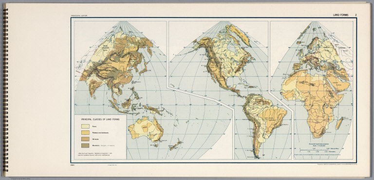
[United States Army Service Forces, American Geographical Society]
Full Title
Land Forms 2.
List No
6351.016
Note
1058-G.
Author
W. & A.K. Johnston Limited
Full Title
Earthquakes & Volcanoes over the Globe. Isobaric Lines and Prevailing Winds of the Globe for January after De Buchan.
List No
6921.018
Author
[Geographisches Institut (Weimar, Germany), Graef, C.]
Full Title
Isothermen der Erde. Verbreitung der Vulcane. Baeume und Strauchgewaechse in Europa. Kulturgewaechse in Europa. (Isotherms of the earth. Spreading of the Volcanos. Trees and bush plants in Europe. Cultural plants in Europe.)
List No
9664.010
Note
Includes table of vegetation zones. This sheet is part of volume 1.
Author
[Geographisches Institut (Weimar, Germany), Graef, C.]
Full Title
Hoehenkarte. (Elevation Map.)
List No
9664.011
Note
Elevational cross-sections from around the world. This sheet is part of volume 1.
Author
[Geographisches Institut (Weimar, Germany), Graef, C.]
Full Title
Isothermen der Erde. Verbreitung der Vulcane. Baeume und Strauchgewaechse in Europa. Kulturgewaechse in Europa. (Isotherms of the earth. Spreading of the Volcanos. Trees and bush plants in Europe. Cultural plants in Europe.) Isotherms of the earth. Spreading of the Volcanos. Trees and bush plants in Europe. Cultural plants in Europe.
List No
9678.010
Note
Includes table of vegetation zones.
Author
Geographisches Institut (Weimar, Germany)
Full Title
Isothermen der Erde. Verbreitung der Vulcane. Baeume und Strauchgewaechse in Europa. Kulturgewaechse in Europa. (Isotherms of the earth. Spreading of the Volcanos. Trees and bush plants in Europe. Cultural plants in Europe.) Isotherms of the earth. Spreading of the Volcanos. Trees and bush plants in Europe. Cultural plants in Europe.
List No
9679.010
Note
Includes table of vegetation zones.
1-45 of 45
|