|
REFINE
Browse All : Geology and Atlas Map of Utah
1-27 of 27
Author
King, Clarence
Full Title
Green River Basin. Map II. (Geological)
List No
0408.003
Note
Map in full color with the legends on either side of the maps. Map extends from Fortification Peak in Wyoming to Piedmont in Utah. Below the map are two geologic cross sections.
Author
King, Clarence
Full Title
Utah Basin. Map III. (Geological)
List No
0408.004
Note
Map in full color with the legends on either side of the maps. Map extends from Piedmont in Utah to Bovine, Utah including the Great Salt Lake. Below the map are two geologic cross sections.
Author
King, Clarence
Full Title
General Sections.
List No
0408.008
Note
In full color. Ten sections shown with the legends on either side of the cross sections.
Full Title
The Hurricane Fault. (1895)
List No
0740.039
Note
Uncolored view and cross section.
Author
[Scovel, James L., O'Brien, Emmett J]
Full Title
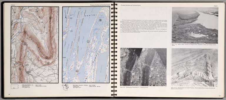
Folds. Plunging Anticlines and Synclines-Humid. Hollidysburg, PA. Belcher Islands, Canada. 1:250,000.
List No
0889.022
Note
Two contour maps and three views on two pages, includes text, and outline location map. Views showing Belcher Islands; Hollidaysburg, Pennsylvania; and Sheep Mountain near Greybull, wyoming. Relief shown by contours and spot height.
Author
[Scovel, James L., O'Brien, Emmett J]
Full Title
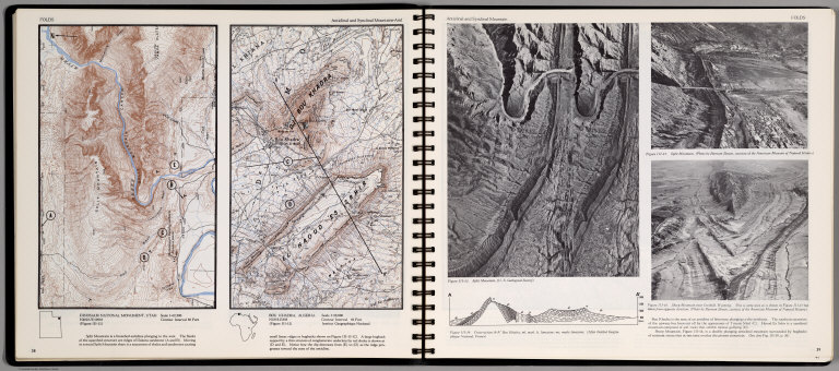
Folds. Plunging Anticlinal and Synclinal Mountain-Arid. Dinosaur National Monument, Utah. Bou Khadra, Algeria. 1:50,000. (on opposite page) Anticlinal and Synclinal Mountain. (with three views).
List No
0889.023
Note
Two contour maps and three views and cross-section on two pages. Includes text, and outline location maps. Two views showing Split Mountin; Sheep Mountain near Grebull; Cross-section A-A' Bou khadra. Relief shown by contours and spot height.
Author
[Scovel, James L., O'Brien, Emmett J]
Full Title
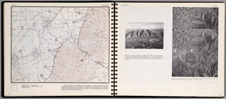
Faults. Mature Scrap. Provo, Utah. (on opposite page) Mature Scrap. Stereopair of the area south of Spanish Fork Canyon ...
List No
0889.029
Note
Contour map, with text. Relief shown by contours and spot height. Includes location map. Insets view: the front of the Wasatch ...
Author
[Scovel, James L., O'Brien, Emmett J]
Full Title
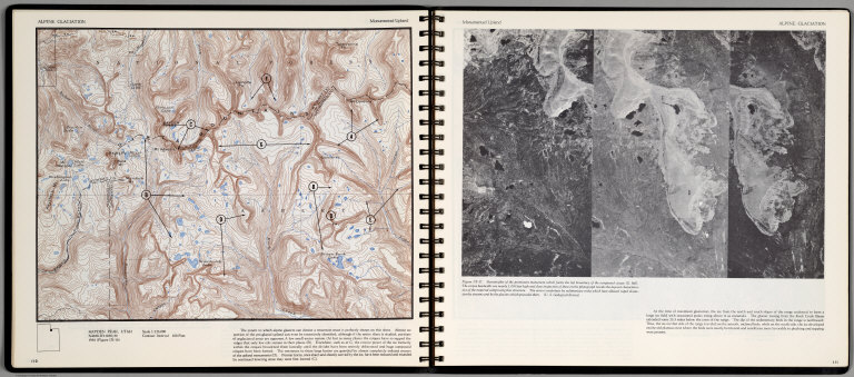
Alpine Glaciation. Monumented Upland. Hayden Peak, Utah. (on opposite page) Stereotriplet of the prominent monument which form the left boundary of the compound cirque.
List No
0889.059
Note
Color map, with text, and location map. Relief shown by contours and spot heights.
Author
[Bishop, F. M., De Motte, B. C., Geological and Geographical Survey of the Territories (U.S.), Powell, John Wesley, 1834-1902, Thompson, A. H. (Almon Harris), 1839-1906]
Full Title
Green River from the Union Pacific Rail Road to the mouth of White River, 1873 (geology). Department of the Interior. U.S. Geological and Geographical Survey of the Territories. Second Division. J.W. Powell, geologist in charge, A.H. Thompson, geographer, B.C. De Motte & F.M. Bishop, topographers. W.H. Graves del. Outlines engraved by S.J. Kubel. U.S. G. and G. Survey, 2d. Div. ... Geology of the Unita Mountains. (Julius Bien Lith.)
List No
2078.002
Note
Colored lithographed map. Relief shown by contours, spot heights and hachures. Shows distribution of 20 sedimentary groups and one eruptive rock Trachyte.
Author
[Geological and Geographical Survey of the Territories (U.S.), Powell, John Wesley, 1834-1902]
Full Title
Structure sections through the Uinta Mountains. U.S. G. and G. Survey, 2d. Div., J.W. Powell, geologist in charge. Geology of the Unita Mountains. (Julius Bien Lith.)
List No
2078.003
Note
Lithograph. Sections 1-11. Horizontal and vertical scale (ca. 1:153,440)
Author
[Geological and Geographical Survey of the Territories (U.S.), Powell, John Wesley, 1834-1902]
Full Title
Displacement diagrams derived from the Structure sections through the Uinta Mountains, pl. I. U.S. G. and G. Survey, 2d. Div., J.W. Powell, geologist in charge. Geology of the Unita Mountains. (Julius Bien Lith.)
List No
2078.004
Note
Lithograph. Diagrams no. 1-22. Horizontal and vertical scale (ca. 1:253,440)
Author
[Geological and Geographical Survey of the Territories (U.S.), Powell, John Wesley, 1834-1902]
Full Title
Stereogram of the displacements of the eastern portion of the Uinta Mountains. U.S. G. and G. Survey, 2d. Div., J.W. Powell, geologist in charge. Geology of the Unita Mountains. (Julius Bien Lith.)
List No
2078.005
Note
Lithograph. Horizontal and vertical scale (ca. 1:253,440)
Author
[Geological and Geographical Survey of the Territories (U.S.), Gilbert, Grove Karl, 1843-1918, Powell, John Wesley, 1834-1902]
Full Title
Bird's-eye view of a part of the Uinta Uplift. Designed by G.K. Gilbert. U.S. G. and G. Survey, 2d. Div., J.W. Powell, geologist in charge. Geology of the Unita Mountains. (Julius Bien Lith.)
List No
2078.006
Note
Lithograph. Block diagram of an area measuring 40 by 50 miles. Vertical and horizontal scales (ca. 1:156,000)
Author
[Geological and Geographical Survey of the Territories (U.S.), Powell, John Wesley, 1834-1902]
Full Title
Stereogram of the displacements of the Yampa Plateau. U.S. G. and G. Survey, 2d. Div., J.W. Powell, geologist in charge. Geology of the Unita Mountains. (Julius Bien Lith.)
List No
2078.007
Note
Lithograph. Horizontal and vertical scale (ca. 1:253,440)
Author
[Dutton, Clarence E. (Clarence Edward), 1841-1912, Geographical and Geological Survey of the Rocky Mountain Region (U.S.), Graves, W. H., Renshawe, J. H. (John Henry), 1852-, Thompson, A. H. (Almon Harris), 1839-1906]
Full Title
Geological map of the district of the high plateaus of Utah. Triangulation by A.H. Thompson, topographers J.H. Renshawe, W.H. Graves. Geology by Capt. C.E. Dutton, U.S.A. Dept. of the Interior, U.S. G. and G. Survey, J.W. Powell in charge. Atlas sheet no. 2, Geology of the high plateaus of Utah by Capt. C.E. Dutton, U.S.A. (Julius Bien, Lith., New York, 1879)
List No
2080.002
Note
Color lithographed map. Contour interval 250 ft.
Author
[Dutton, Clarence E. (Clarence Edward), 1841-1912, Geographical and Geological Survey of the Rocky Mountain Region (U.S.)]
Full Title
Map of portions of Utah and Arizona showing the arrangement of faults and flexures in the Kaibabs and high plateaus. Dept. of the Interior, U.S. G. and G. Survey, J.W. Powell in charge. Atlas sheet no. 4, Geology of the high plateaus of Utah by Capt. C.E. Dutton, U.S.A. (Julius Bien, Lith., New York, 1879)
List No
2080.004
Note
Lithographed map. Relief shown by hachures.
Author
[Dutton, Clarence E. (Clarence Edward), 1841-1912, Geographical and Geological Survey of the Rocky Mountain Region (U.S.)]
Full Title
Stereogram of displacements in the district of the high plateaus of Utah. Showing the vertical displacements of a given horizon since the close of the Green River epoch, with the supposition that there had been no erosion. By C.E. Dutton, Capt. of Ordnance, U.S.A. Dept. of the Interior, U.S. G. and G. Survey, J.W. Powell in charge. Atlas sheet no. 5, Geology of the high plateaus of Utah by Capt. C.E. Dutton, U.S.A. (Julius Bien, Lith., New York, 1879)
List No
2080.005
Note
Lithographed map. Horizontal and vertical scale (ca. 1:252,440). Plateaus, faults and valleys identified with letters or numbers.
Author
[Dutton, Clarence E. (Clarence Edward), 1841-1912, Geographical and Geological Survey of the Rocky Mountain Region (U.S.)]
Full Title
Structure sections through the high plateaus. Dept. of the Interior, U.S. G. and G. Survey, J.W. Powell in charge. Atlas sheet no. 6, Geology of the high plateaus of Utah by Capt. C.E. Dutton, U.S.A. (Julius Bien, Lith., New York, 1879)
List No
2080.006
Note
Five lithographed sections (no. 1-5) in 7 segments. "Horizontal and vertical scale 1 inch - 2 miles."
Author
[Dutton, Clarence E. (Clarence Edward), 1841-1912, Geographical and Geological Survey of the Rocky Mountain Region (U.S.)]
Full Title
Structure sections through the high plateaus. Dept. of the Interior, U.S. G. and G. Survey, J.W. Powell in charge. Atlas sheet no. 7, Geology of the high plateaus of Utah by Capt. C.E. Dutton, U.S.A. (Julius Bien, Lith., New York, 1879)
List No
2080.007
Note
Four lithographed sections (no. 6-9) in 8 segments. "Horizontal and vertical scale 1 inch = 4 miles."
Author
Wheeler, G.M.
Full Title
Central & Western Utah Atlas Sheet Number 50. Weyss, Herman & Aguirre Del. Expeditions of 1872 & 1873, Under the Command of 1st Lieut. Geo. M. Wheeler, Corps of Engineers, U.S. Army. U.S. Geographical Surveys West Of The One Hundredth Meridian.
List No
2738.036
Note
Full color geologic formations shown in crayon on map base used in P1281-64. Salt Lake City placed outside the map border. Color legend provided at right of map.
Author
Wheeler, G.M.
Full Title
Atlas Sheet Number 58. Parts Of E. California, S.E. Nevada, N.W. Arizona & S.W. Utah. Atlas Sheet Number 66. Weyss, Herman & Aguirre, Del. Expeditions of 1872 & 1873, Under the Command of 1st. Lieut. Geo. M. Wheeler, Corps of Engineers, U.S. Army. Geological Assistants: G.K. Gilbert, A.R. Marvine and E.E. Howell. U.S. Geographical Surveys West Of The One-Hundredth Meridian.
List No
2738.045
Note
Two partial atlas sheets on one page. In crayon and showing geological formations in tints. Color legend on outside of each map.
Author
Wheeler, G.M.
Full Title
Southern And Southwestern Utah. Atlas Sheet Number 59. Weyss, Herman & Aguirre, Del's. Expeditions of 1872 & 1873 Under the Command of 1st. Lieut. Geo. M. Wheeler, Corps of Engineers, U.S. Army. Geological Assistants: G.K. Gilbert, A.R. Marvine, E.E. Howell. Explorations & Surveys West Of The One-Hundredth Meridian.
List No
2738.048
Note
In crayon and showing geological formations in full color tints. Legend to the right of map. Top left of map without geologic representation.
Author
Wheeler, G.M.
Full Title
Parts Of Northern & North Western Arizona & Southern Utah, Atlas Sheet No. 67. Weyss, Herman & Lang, Del. Expeditions of 1871, 1872, & 1873. Under the Command of 1st. Lieut. Geo. M. Wheeler, Corps of Engineers, U.S. Army. G.K. Gilbert, A.R. Marvine, E.E. Howell, Geological Assistants. U.S. Geographical Surveys West Of The 100th Meridian.
List No
2738.069
Note
Grand Canyon sheet using crayon as in P1281-118 with full color tint overlay of geologic formations. Legend to the right of the map border.
Author
Dutton, Clarence E. (Clarence Edward), 1841-1912
Full Title
Sketch Map of the Western Part of the Plateau Province showing The Faults of the Grand Canon District and High Plateaus. Sheet III. Julius Bien, lith. N.Y. C.E. Dutton, Geologist-in-Charge. U.S. Geological Survey, Geology of the Grand Canon District.
List No
4713.002
Note
Map without color.
Author
Dutton, Clarence E. (Clarence Edward), 1841-1912
Full Title
Geologic Map Showing The South-Western Portion Of The Mesozoic Terraces And The Vicinity Of The Hurricane Fault. Atlas Sheet XX. Geology by C.E. Dutton. Julius Bien & Co. lith. U.S. Geological Survey, Geology of the Grand Canon District.
List No
4713.022
Note
In full color. First of four sheets.
Author
Dutton, Clarence E. (Clarence Edward), 1841-1912
Full Title
Geologic Map Of The Mesozoic Terraces Of The Grand Canon District And The Southern Portions Of The High Plateaus. Atlas Sheet XXI. Geology by C.E. Dutton. Julius Bien & Co. lith. U.S. Geological Survey, Geology of the Grand Canon District.
List No
4713.023
Note
In full color. Second of four sheets.
Author
[U.S. Geological Survey, Alpha, Tau Rho]
Full Title
Relation of Ore Bodies to Surface of Tintic Quartzite, East Tintic District, Utah
List No
6353.130
1-27 of 27
|