|
Author
California Division of Mines and Geology
Full Title
Geologic Map of California, Los Angeles Sheet.
List No
6347.037
Note
Full color. Olaf P. Jenkins Edition.
Author
[Berghaus, Heinrich, Berghaus, Hermann, Schmidt, C., Risch, M.]
Full Title
Tieflander. Entw. v. Herm. Berghaus 1883, Ausg. 1887. Gez. v. C. Schmidt u. M. Risch. Gotha: Justus Perthes. (On upper margin) I. Abt. Geologie No. II. Berghaus' physikal atlas No. 2. (to Accompany) Berghaus' Physikalischer Atlas. (Begrundet 1836 durch Heinrich Berghaus) ... Gotha: Justus Perthes. 1892.
List No
4391.013
Note
14 color lithograph maps with insets on 1 sheet. Includes: Die Heutigen Niederlande, with insets: Niederlande in 1. Jahrhundert -- Niederlande in X. Jahrhundert, at scale of 1: 6,000,000. Fen District -- El-Ghor oder das Jordan Thal -- Kaspisches Tiefland und Manytsch Niederrung -- Natron-Seen -- El Fajum -- Nordrand der Libyschen Wuste -- Das Todte Thal -- Colorado-Wuste -- Nordrand der Algerischen Sahara -- Goban n. Paulistischke -- Sud-Australische Seen -- Tiefland Asale -- Assal-See. Relief shown by contours and spot heights. Depth shown by gradient tints and soundings. Prime meridian is Greenwich.
Author
[U.S. Geological Survey, Alpha, Tau Rho]
Full Title
Southern California Borderland.
List No
6353.087
Author
King, Clarence
Full Title
Nevada Basin. Map V. (Geological)
List No
0408.006
Note
Map in full color with the legends on either side of the maps. Map extends from Argenta, Nevada to the west of Pyramid Lake (Lake Tahoe) in California. Below the map are two geologic cross sections.
Author
King, Clarence
Full Title
General Sections.
List No
0408.008
Note
In full color. Ten sections shown with the legends on either side of the cross sections.
Author
[Scovel, James L., O'Brien, Emmett J]
Full Title
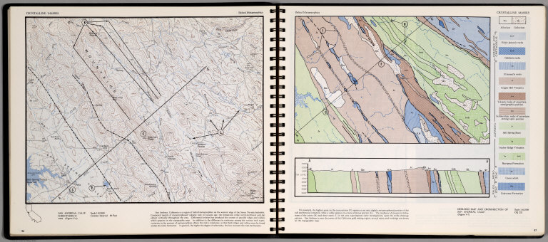
Crystalline Masses. Belted Metamorphic. San Andreas, Calif. (on opposite page) Geologic Map and Cross-Section of San Andreas, Calif.
List No
0889.032
Note
Contour and geologic maps, with text, and location map. Relief shown by contours and spot height.
Author
[Scovel, James L., O'Brien, Emmett J]
Full Title
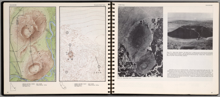
Vulcanism. Extrusive Cinder Cones. Menan Buttes, Idaho. Amboy Cratet, Calif. (on opposite page) Cinder Cones. (Views of) Manon Buttes, Idaho, and Amboy Crater, California.
List No
0889.035
Note
Two contour maps on one page. With location maps. Two views, and text on opposite page. Relief shown by contours and spot height.
Author
[Scovel, James L., O'Brien, Emmett J]
Full Title
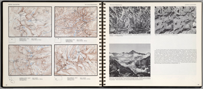
Alpine Glaciation. The Cycle of Glacial Erosion. Georgetown, Colo. Scale 1:62,500. Cloud Peak, Wyo. Scale 1:125,000. Mineral King, Calif. Scale 1:62,500. Phillipsburg, Mont. Scale 1:125,000.(on opposite page three views of )The Cycle of Glacial Erosion.
List No
0889.057
Note
Four on one page, with text, and location map. Includes three views of Georgetown, Colorado; Cloud Peak, Wyoming; and A series of paternoster lakes in a maturely dissected glacial range. Relief shown by contours and spot heights.
Author
[Scovel, James L., O'Brien, Emmett J]
Full Title
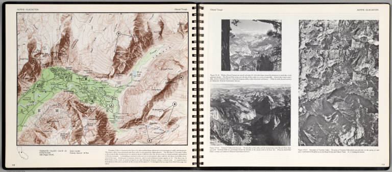
Alpine Glaciation. Glacial Trough. Yosemite Valley, Calif. (S) (on opposite page) Stereopair of Yosemite Valley, (two views) Within Merced Canyon ..., Yosemite Valley from the West ...
List No
0889.060
Note
Color map, with text, and location map. Relief shown by contours and spot heights.
Author
[Scovel, James L., O'Brien, Emmett J]
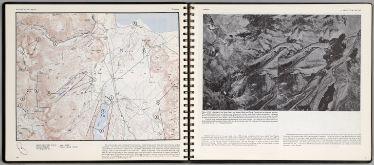
Full Title
Alpine Glaciation. Moraine. Mono Craters, Calif. (on opposite page) Stereopair of Mono Craters ...
List No
0889.061
Note
Color map, with text, and location map. Relief shown by contours and spot heights.
Author
[Scovel, James L., O'Brien, Emmett J]
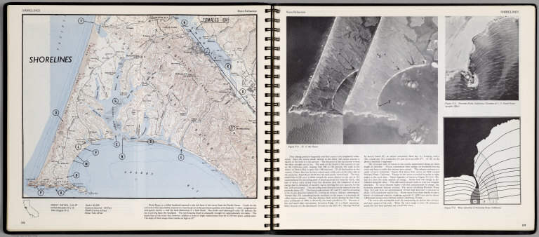
Full Title
Shorelines. Wave Refraction. Point Reyes, Calif. (on opposite page) Three views.
List No
0889.068
Note
Contour color map, with location map and text. Views: aerial views of Point Reyes, Purisima Point, California, and Wave Fraction at Purisima Point, California. Relief shown by contours and spot heights.
Author
[Scovel, James L., O'Brien, Emmett J]
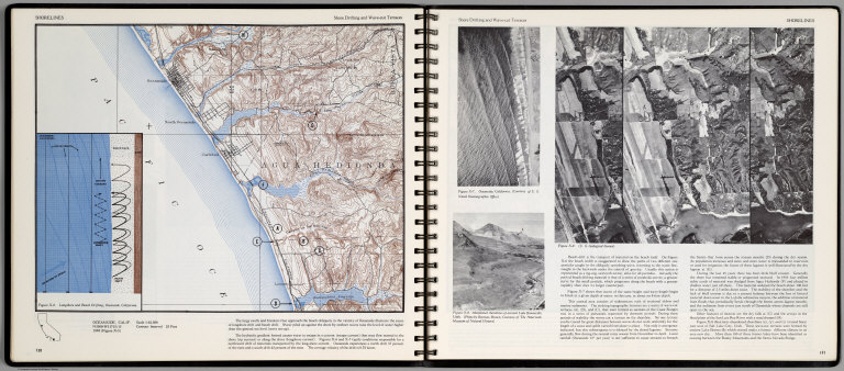
Full Title
Shorelines. Shore Drifting and Wave-cut Terraces. Oceanside, Calif. (inset) Longshore and Beach Drifting, Oceanside, California. (on opposite page three views).
List No
0889.069
Note
Contour color map, with location map and text. Views: Oceanside, California; Abandoned shorlines of ancient Lake Bonnevile, Utah; and view showing series of wave-cut terraces (A), (B), and (C) ... Relief shown by contours and spot heights.
Author
[Scovel, James L., O'Brien, Emmett J]
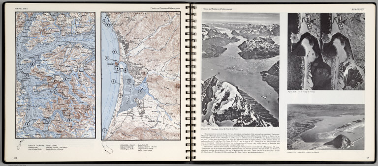
Full Title
Shorelines. Fiords and Features of Submergence. Narvik, Norway. Cayucos, Calif. Scale 1:62,500. (insets) Providence, R.I., and Outwash Plain before and after water attack. (with three views on opposite page).
List No
0889.073
Note
Two contour color maps, with location map and text. View of Greenland, and two views of Morro Bay, California. Relief shown by contours and spot heights.
Author
[Scovel, James L., O'Brien, Emmett J]
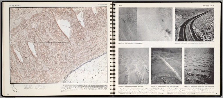
Full Title
Eolian Activity. Transverse Dunes. Cactus, Calif. (with aerial views on opposite page)
List No
0889.081
Note
Contour color maps, with location map and text. Aerial views: Cactus, California, Dunes between Yuma, Arizona and Calexico, California, Immense area of transverse dunes, western Libya, Longitudinal dunes on a rocky surface northern Egypt, and Pyramid or star dunes on a sandy surface, western Algeria. Relief shown by contours and spot heights.
Author
Berghaus, Hermann
Full Title
Nord-Amerika. Ubersicht von Nord-Amerika. (with) Virginia-Silber-Minen. (with) Das Yosemite-Thal. (with) Landenge von Tehuantepec n. J.C. Spear 1871. (with) Landenge von Nicaragua. (with) Die Krater des Turrialba. (with) Landenge von Panama. (with) Seeboden der New-York-Bay. (with) Popocatepetl. (with) Citlaltepetl. (with) Canons des Colorado. (with) Yellowstone-National-Park. (with) Reykjanes und Geyser nach Th. Thoroddsen. Entw. v. Herm. Berghaus 1886, Ausg. 1887. Nebenkarten gez. v. M. Risch. Gotha: Justus Perthes (1892)
List No
1578.012
Note
Lithographed geologic map, color with 12 inset maps. Relief shown by spot heights. Some inset maps are topographic maps showing relief by hachures and spot heights.
Author
California. State Earthquake Investigation Commission
Full Title
Geomorphic map of California and Nevada with portions of Oregon and Idaho showing the diastrophic character of the relief, the steep descent from the sub-continental shelf to the floor of the Pacific, and the more important known faults. Earthquake Investigation Commission. Drawn by M. Solem. A. Hoen & Co., Baltimore. (Carnegie Institution of Washington, 1908)
List No
2130.001
Note
Color. Relief shown by hachures; depths by bathymetric isolines. Shows railways, towns, counties and drainage.
Author
California. State Earthquake Investigation Commission
Full Title
Map of a portion of the coast of California showing the San Andreas Rift from Point Arena to Fort Ross and the trace of the fault of April 18, 1906. Earthquake Investigation Commission. Julius Bien & Co., N.Y. (Carnegie Institution of Washington. 1908)
List No
2130.002
Note
Color. Also shows settlements, townships and sections, roads and drainage. "Compiled from the official maps of Sonoma and Mendocino Counties."
Author
[California. State Earthquake Investigation Commission, Matthes, Francois E.]
Full Title
Detail map of a typical portion of the San Andreas Rift near Fort Ross, Sonoma County, California showing its geomorphic features and the trace of the fault by Francois E. Matthes. Earthquake Investigation Commission. A. Hoen & Co., Baltimore. (Carnegie Institution of Washington. 1908)
List No
2130.003
Note
Color. Contour interval 5 ft. Shows roads, trails, houses, fences, ponds, streams, marshes, etc. Inset: Index map.
Author
California. State Earthquake Investigation Commission
Full Title
Map of the region about San Francisco Bay showing the relation of the city of San Francisco to the San Andreas Rift, the fault of April 18, 1906 and the fault of October 21, 1868. Earthquake Investigation Commission. Julius Bien & Co., Lith., N.Y. (Carnegie Institution of Washington. 1908)
List No
2130.004
Note
Color. Relief shown by contours and spot heights; depths by soundings and isoline. "Topography by the C. and G. Survey and the U.S. Geological Survey."
Author
California. State Earthquake Investigation Commission
Full Title
Map of a portion of the Coast Ranges of California showing the San Andreas Rift. Earthquake Investigation Commission. Julius Bien & Co., Lith., N.Y. (Carnegie Institution of Washington. 1908)
List No
2130.005
Note
Color. Contour interval 500 ft. Shows settlements, railroads, etc.
Author
[California. State Earthquake Investigation Commission, U.S. Geological Survey]
Full Title
California, Mt. Pinos quadrangle of the U.S. Geological Survey showing the San Andreas Rift. Earthquake Investigation Commission. (Carnegie Institution of Washington. 1908)
List No
2130.006
Note
Color. 30-minute topographic quadrangle. Relief shown by contours and spot heights. Covers portions of Ventura, Kern and Santa Barbara counties.
Author
[California. State Earthquake Investigation Commission, U.S. Geological Survey]
Full Title
California, Tejon quadrangle of the U.S. Geological Survey showing the San Andreas Rift. Earthquake Investigation Commission. (Carnegie Institution of Washington. 1908)
List No
2130.007
Note
Color. 30-minute topographic quadrangle. Relief shown by contours and spot heights. Covers portions of Kern, Los Angeles and Ventura counties.
Author
[California. State Earthquake Investigation Commission, U.S. Geological Survey]
Full Title
California, Palmdale quadrangle of the U.S. Geological Survey showing the San Andreas Rift. Earthquake Investigation Commission. A. Hoen & Co., Baltimore. (Carnegie Institution of Washington. 1908)
List No
2130.008
Note
Color. 30-minute topographic quadrangle. Relief shown by contours and spot heights. Covers portions of Kern and Los Angeles counties.
Author
[California. State Earthquake Investigation Commission, U.S. Geological Survey]
Full Title
California, Rock Creek quadrangle of the U.S. Geological Survey showing the San Andreas Rift. Earthquake Investigation Commission. Andrew B. Graham Co., Lithographers, Washington, D.C. (Carnegie Institution of Washington. 1908)
List No
2130.009
Note
Color. 15-minute topographic quadrangle. Relief shown by contours and spot heights. In Los Angeles County.
Author
[California. State Earthquake Investigation Commission, U.S. Geological Survey]
Full Title
California, San Antonio quadrangle of the U.S. Geological Survey showing the San Andreas Rift. Earthquake Investigation Commission. Andrew B. Graham Co., Lithographers, Washington, D.C. (Carnegie Institution of Washington. 1908)
List No
2130.010
Note
Color. 15-minute topographic quadrangle. Relief shown by contours and spot heights. Covers portions of Los Angeles and San Bernardino counties.
Author
[California. State Earthquake Investigation Commission, U.S. Geological Survey]
Full Title
California, Hesperia quadrangle of the U.S. Geological Survey showing the San Andreas Rift. Earthquake Investigation Commission. Andrew B. Graham Co., Lithographers, Washington, D.C. (Carnegie Institution of Washington. 1908)
List No
2130.011
Note
Color. 15-minute topographic quadrangle. Relief shown by contours and spot heights. Covers portion of San Bernardino County.
Author
[California. State Earthquake Investigation Commission, U.S. Geological Survey]
Full Title
California, San Bernardino quadrangle of the U.S. Geological Survey showing the San Andreas Rift. Earthquake Investigation Commission. Andrew B. Graham Co., Lithographers, Washington, D.C. (Carnegie Institution of Washington. 1908)
List No
2130.012
Note
Color. 15-minute topographic quadrangle. Relief shown by contours and spot heights. Covers portions of San Bernardino and Riverside counties.
Author
[California. State Earthquake Investigation Commission, U.S. Geological Survey]
Full Title
California, Redlands quadrangle of the U.S. Geological Survey showing the San Andreas Rift. Earthquake Investigation Commission. Andrew B. Graham Co., Lithographers, Washington, D.C. (Carnegie Institution of Washington. 1908)
List No
2130.013
Note
Color. 15-minute topographic quadrangle. Relief shown by contours and spot heights. Covers portions of San Bernardino and Riverside counties.
Author
[California. State Earthquake Investigation Commission, U.S. Geological Survey]
Full Title
California, San Gorgonio quadrangle of the U.S. Geological Survey showing the San Andreas Rift and the Mission Creek Fault. Earthquake Investigation Commission. Andrew B. Graham Co., Lithographers, Washington, D.C. (Carnegie Institution of Washington. 1908)
List No
2130.014
Note
Color. 30-minute topographic quadrangle. Relief shown by contours and spot heights. Covers portions of San Bernardino and Riverside counties.
Author
[California. State Earthquake Investigation Commission, U.S. Geological Survey]
Full Title
California, San Jacinto quadrangle of the U.S. Geological Survey showing the San Andreas Rift, the Mission Creek Fault and the San Jacinto Fault. Earthquake Investigation Commission. Andrew B. Graham Co., Lithographers, Washington, D.C. (Carnegie Institution of Washington. 1908)
List No
2130.015
Note
Color. 30-minute topographic quadrangle. Relief shown by contours and spot heights. Covers portions of Riverside County.
Author
California. State Earthquake Investigation Commission
Full Title
Map of the city of Santa Rosa, Sonoma County, California showing the portions destroyed by the earthquake of April 18, 1906, and by the fire consequent thereto. Earthquake Investigation Commission. A. Hoen & Co., Baltimore. (Carnegie Institution of Washington. 1908)
List No
2130.016
Note
Relief shown by hachures. Shows buildings destroyed by earthquake and following fire.
Author
[California. State Earthquake Investigation Commission, Lawson, Andrew C., Wood, Harry O.]
Full Title
Geological map of the city of San Francisco by Andrew C. Lawson. To accompany the paper by H.O. Wood. Earthquake Investigation Commission. A. Hoen & Co. (Carnegie Institution of Washington. 1908)
List No
2130.017
Note
Color. Relief shown by contours and spot heights. Shows 10 geologic units and original shoreline. "Topography by the Coast and Geodetic Survey." For sections see map 18.
Author
[California. State Earthquake Investigation Commission, Wood, Harry O.]
Full Title
Geological profiles with corresponding intensity curves across the city of San Francisco. To accompany the paper by H.O. Wood. Earthquake Investigation Commission. A. Hoen & Co. (Carnegie Institution of Washington. 1908)
List No
2130.018
Note
Color. Six sections with legend and explanatory note. Shows 10 geologic units. Accompanies map 17.
Author
[California. State Earthquake Investigation Commission, Wood, Harry O.]
Full Title
Map of San Francisco showing distribution of apparent intensity of the earthquake shock by H.O. Wood. Earthquake Investigation Commission. A. Hoen & Co., Baltimore. (Carnegie Institution of Washington. 1908)
List No
2130.019
Note
Color. Relief shown by contours and spot heights. "Topography by the Coast and Geodetic Survey."
Author
California. State Earthquake Investigation Commission
Full Title
Map of the city of San Francisco showing the streets and the burnt area, 1906. Earthquake Investigation Commission. Britton & Rey, engravers, San Francisco. (Carnegie Institution of Washington. 1908)
List No
2130.020
Note
Color. Shows block numbers, tracts, railroads, original shoreline, etc.
Author
[California. State Earthquake Investigation Commission, U.S. Geological Survey]
Full Title
California, San Mateo quadrangle of the U.S. Geological Survey showing the distribution of apparent intensity, the known faults, and the routes examined. Earthquake Investigation Commission. A. Hoen & Co., Baltimore. (Carnegie Institution of Washington. 1908)
List No
2130.021
Note
Color. 15-minute topographic quadrangle. Relief shown by contours and spot heights. Covers portions of San Mateo and San Francisco counties. Rossi-Forel scale.
Author
[California. State Earthquake Investigation Commission, U.S. Geological Survey]
Full Title
California, Santa Cruz quadrangle of the U.S. Geological Survey showing the distribution of apparent intensity, the known faults, the routes examined and the numbered localities referred to in the text. Earthquake Investigation Commission. A. Hoen & Co., Baltimore. (Carnegie Institution of Washington. 1908)
List No
2130.022
Note
Color. 30-minute topographic quadrangle. Relief shown by contours and spot heights. Covers portions of San Mateo, Santa Clara and Santa Cruz counties. Rossi-Forel scale.
Author
California. State Earthquake Investigation Commission
Full Title
Map of California and Nevada showing the distribution of apparent intensity in the region affected by the earthquake of April 18, 1906. Drawn by M. Solem. Earthquake Investigation Commission. A. Hoen & Co., Baltimore. (Carnegie Institution of Washington. 1908)
List No
2130.023
Note
Color. Covers also parts of Oregon and Idaho. Rossi-Forel scale.
Author
California. State Earthquake Investigation Commission
Full Title
Map of the Coast Range Region of Middle California showing the distribution of earth movement on April 18, 1906 as revealed by the displacement of the triangulation stations of the Coast and Geodetic Surveyed, determined by resurvey, 1906-07. Drawn by M. Solem. Earthquake Investigation Commission. A. Hoen & Co., Baltimore. (Carnegie Institution of Washington. 1908)
List No
2130.024
Note
Color. Shows fault of 1906, movement of 1906, successive movements of 1868 and 1906, combined movements of 1868 and 1906, railroads, settlements, etc.
Author
California. State Earthquake Investigation Commission
Full Title
Distribution of earth movement on April 18, 1906 and in 1868 as revealed by the displacement of the triangulation stations of the Coast and Geodetic Surveyed, determined by resurvey, 1906-07. Earthquake Investigation Commission. A. Hoen & Co., Baltimore. (Carnegie Institution of Washington. 1908)
List No
2130.025
Note
Four color maps. Contents: No. 1. Point Arena and vicinity -- No. 2. Fort Ross and vicinity -- No. 3. Tomales Bay -- No. 4. Colma and vicinity.
Author
Wheeler, G.M.
Full Title
Atlas Sheet Number 58. Parts Of E. California, S.E. Nevada, N.W. Arizona & S.W. Utah. Atlas Sheet Number 66. Weyss, Herman & Aguirre, Del. Expeditions of 1872 & 1873, Under the Command of 1st. Lieut. Geo. M. Wheeler, Corps of Engineers, U.S. Army. Geological Assistants: G.K. Gilbert, A.R. Marvine and E.E. Howell. U.S. Geographical Surveys West Of The One-Hundredth Meridian.
List No
2738.045
Note
Two partial atlas sheets on one page. In crayon and showing geological formations in tints. Color legend on outside of each map.
Author
Becker, George F.
Full Title
Geological Map of the Sulphur Bank District. U.S. Geological Survey. Monograph XIII, Atlas Sheet IV. S.H. Bodfish 1882, J.D. Hoffman 1884, Topographers. Giles Litho. & Liberty Printing Co. Geo. F. Becker, Geologist in charge.
List No
4580.002
Note
Shows in color three classes of rock. Relief shown by 20-foot contour lines. Shows mines, streams, and settlements.
Author
Becker, George F.
Full Title
Geological Map of the Knoxville District. U.S. Geological Survey. Monograph XIII, Atlas Sheet V. Topography by J.D. Hoffman 1883. Geo. F. Becker, Geologist in charge. Topographical Map of the Region of Clear Lake. Compiled by C.F. Hoffmann. Geo. F. Becker, Geologist in charge.
List No
4580.003
Note
Two maps on one sheet. Knoxville District map relief shown with 25-foot contours. Shows in color five classes of rock. Longitude and latitude shown. Scale 1:15,000. Clear Lake Region map shows topography with shaded relief, streams, mines, settlements, and roads. Scale 1:95,000. Outlines of Sulphur Bank District and Knoxville District shown.
Author
Becker, George F.
Full Title
Geological Map of the New Idria District. U.S. Geological Survey. Monograph XIII, Atlas Sheet VI. J.D. Hoffman, Topographer. Giles Litho. & Liberty Printing Co. N.Y. Geo. F. Becker, Geologist in charge.
List No
4580.004
Note
Shows in color three classes of rock. Relief shown by 40-foot contour lines. Shows streams, settlements, mines, trails, and roads.
Author
Becker, George F.
Full Title
Geological Map of the New Almaden Mining District. U.S. Geological Survey. Monograph XIII, Atlas Sheet VII. Topography by S.W. Bodfish and others. Giles Litho. & Liberty Printing Co. N.Y. Geo. F. Becker, Geologist in charge.
List No
4580.005
Note
Shows in color six classes of rock. Relief shown by 20-foot contour lines. Shows streams, settlements, mines, and roads.
Author
Becker, George F.
Full Title
Ore-Bodies and Topography of Mine-Hill, New Almaden. U.S. Geological Survey. Monograph XIII, Atlas Sheet VIII. Compiled by F. Reade 1885. Giles Litho. & Liberty Printing Co. N.Y. Geo. F. Becker, Geologist in charge.
List No
4580.006
Note
Shows in topography with 10-foot contours, ore bodies with cross-hatching, mine dumps with hachures, +streams, roads, tramways, tunnels and shafts.
Author
Becker, George F.
Full Title
Plan of the New Almaden Mine. U.S. Geological Survey. Monograph XIII, Atlas Sheet IX. Compiled by F. Reade 1885. Giles Litho. & Liberty Printing Co. N.Y. Geo. F. Becker, Geologist in charge.
List No
4580.007
Note
Shows depths, tunnels, drifts, galleries, and shafts in brilliant color.
Author
Becker, George F.
Full Title
Longitudinal Section of the South Ore Channel. New Almaden Mine. U.S. Geological Survey. Monograph XIII, Atlas Sheet X. Compiled by F. Reade 1885. Giles Litho. & Liberty Printing Co. N.Y. Geo. F. Becker, Geologist in charge.
List No
4580.008
Note
Shows depths, tunnels, drifts, galleries, and shafts.
Author
Becker, George F.
Full Title
North and South Section , 550 Feet West of Randol Shaft, New Almaden Mine. North and South Section through the Randol Shaft, New Almaden Mine. U.S. Geological Survey. Monograph XIII, Atlas Sheet XI. Compiled by F. Reade 1885. Geo. F. Becker, Geologist in charge.
List No
4580.009
Note
Two vertical sections on one sheet. Shows depths, tunnels, drifts, galleries, and shafts.
Author
Becker, George F.
Full Title
East and West Vertical Section, New Almaden Mine. U.S. Geological Survey. Monograph XIII, Atlas Sheet XII. Compiled by F. Reade 1885. Geo. F. Becker, Geologist in charge.
List No
4580.010
Note
Shows depths, tunnels, drifts, galleries, and shafts.
|