|
REFINE
Browse All : Geology and Atlas Map of British Isles
1-9 of 9
Forbes, Edward, 1815-1854; Johnston, Ale... Geological, palaeontological map British... 1854 0372.005 Related Author
[Forbes, Edward, 1815-1854, Johnston, Alexander Keith, 1804-1871]
Full Title
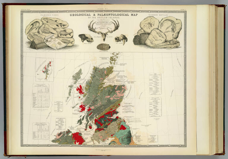
Geological & palaeontological map of the British Islands. By A.K. Johnston, F.R.G.S. From the sketches & notes of Professor Edward Forbes, F.R.S. of Kings College London & of the Government School of Mines, President of the Geological Society. Engraved by W. & A.K. Johnston. William Blackwood & Sons, Edinburgh & London. 1st March 1854, (1856)
List No
0372.005
Note
Col. lithographed map. Northern half covering Scotland and parts of Ireland, Northern Ireland and England. Explanation on pl. 6. Includes inset of the Shetland Islands, tables, and illustrations of "Palaeozoic fishes," "Tertiary & post Tertiary Mamallia," and "Secondary reptiles." "Geology no. 5."
Forbes, Edward, 1815-1854; Johnston, Ale... Palaeontological map (British Islands). 1854 0372.006 Related Author
[Forbes, Edward, 1815-1854, Johnston, Alexander Keith, 1804-1871]
Full Title
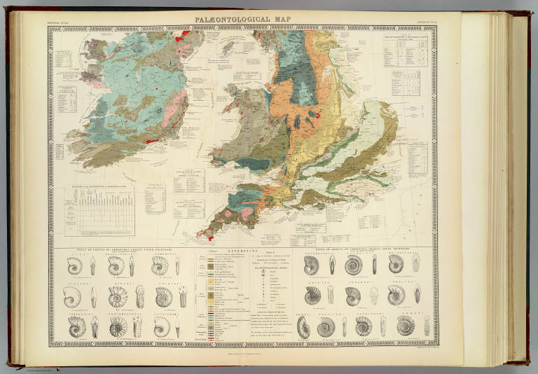
Palaeontological map (British Islands. By A.K. Johnston, F.R.G.S. From the sketches & notes of Professor Edward Forbes, F.R.S. of Kings College London & of the Government School of Mines, President of the Geological Society). Engraved by W. & A.K. Johnston. William Blackwood & Sons, Edinburgh & London. 1st March 1854, (1856)
List No
0372.006
Note
Col. lithographed map. Southern half of "Geological & palaeontological map of the British Islands." Covers Wales and most of England and Ireland. Shows 25 geologic units. Includes notes, tables and illustrations: Types of groups of Ammonites ... after Von Buch & D'Orbigny." "Geology no. 6."
Forbes, Edward, 1815-1854; Johnston, Ale... Composite: Geological, palaeontological ... 1854 0372.007 Related Author
[Forbes, Edward, 1815-1854, Johnston, Alexander Keith, 1804-1871]
Full Title
(Composite of) Geological & palaeontological map of the British Islands. By A.K. Johnston, F.R.G.S. From the sketches & notes of Professor Edward Forbes, F.R.S. of Kings College London & of the Government School of Mines, President of the Geological Society. Engraved by W. & A.K. Johnston. William Blackwood & Sons, Edinburgh & London. 1st March 1854, (1856)
List No
0372.007
Note
Col. lithographed map on 2 sheets. Southern sheet entitled: Palaeontological map. Shows 25 geologic units. Includes inset of the Shetland Islands, notes, tables, and illustrations of "Palaeozoic fishes," "Tertiary & post Tertiary Mamallia," and "Secondary reptiles, " and "Types of groups of Ammonites ... after Von Buch & D'Orbigny." "Geology no. 5. ... no. 6."
Author
Malte-Brun, Conrad, 1775-1826
Full Title
Carte Physique et Mineralogique des Isles Britanniques presentus les Bassins, les principales Montagnes, les Cours d'Eau, les Roches, et les substances Minerales. 1832. Grave par Thierry.
List No
0458.024
Note
Engraved map. Geologic units listed and described in legend and depicted in full color. Major relief depicted with hachures. Rivers, lakes, islands, and basins shown. Includes 2 scales.
Author
[Murchison, Roderick Impey, Sir, 1792-1871, Society for the Diffusion of Useful Knowledge (Great Britain)]
Full Title
Geological map of England and Wales. Published under the superintendence of the Society for the Diffusion of Useful Knowledge. 1843. Arranged by Roderick Impey Murchison ... S.P. Woodward del. Col(oure)d. by T. Malby. J. & C. Walker sculpt. Published by Chapman & Hall 186 Strand Decr. 15th. 1843. (1844)
List No
0890.012
Note
Engraved map. Geologic units hand col. Also shows railroads, canals, navigable rivers and dip of strata.
Author
[Stanford, Edward, Woodward, H.B.]
Full Title
Geological Map of the British Isles by Edward Best. Edward Best, Geological Survey.(in set) Orkney and Shetland Islands.
List No
0949.018
Note
Shows 27 geologic units.
Author
[Stanford, Edward, Woodward, H.B.]
Full Title
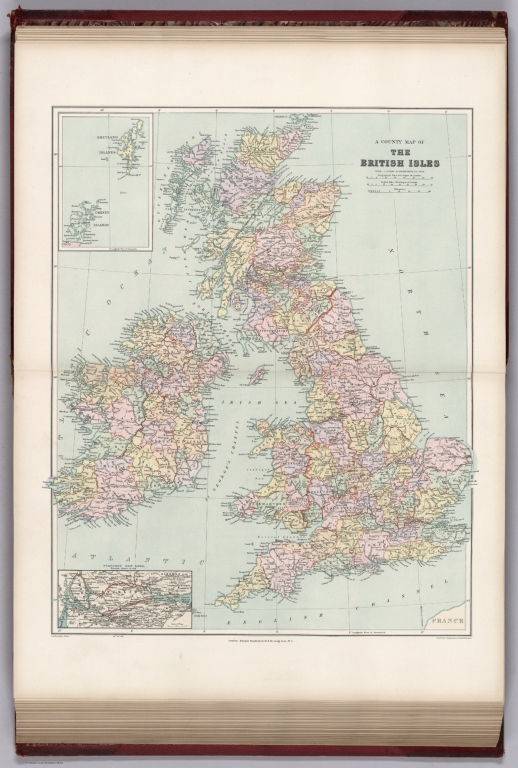
A County Map of the British Isles. (inset) Orkney and Shetland Islands.
List No
0949.019
Note
Shows 27 geologic units.
Author
Stanford, Edward, 1827-1904
Full Title
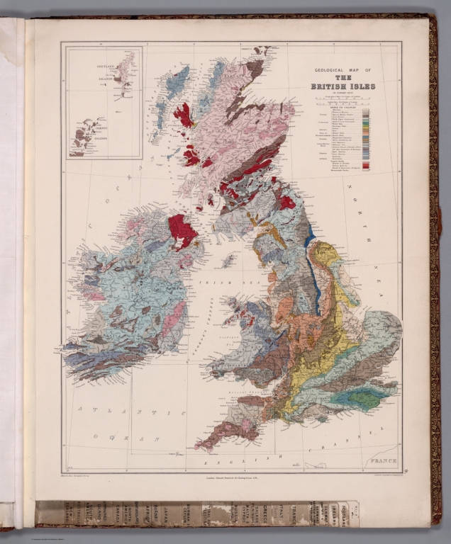
9. A geological map of the British Isles. London: Edward Stanford, 55 Charing Cross, S.W. Stanford's Geographical Establishment.
List No
14053.067
Note
Geological map of the British Isles, in colored lithograph. Shows railways, drainage, and geological character of land. Includes a legend indicating geological periods (tertiary, cretaceous, jurassic, etc.), as well as two bar scales. With inset: Shetland Islands. 59 x 46 cm, on sheet 71 x 55 cm. In Vol. II.
Author
[Best, Edward, Edward Stanford Ltd., Stanford, Edward]
Full Title
Geological map of the British Isles by Edward Best. Edward Best, Geological Survey. London atlas series. Stanford's Geographical Establishment. London : Edward Stanford, 12, 13 & 14 Long Acre, W.C. (1901)
List No
5075.010
Note
Full color. Shows 27 geologic units. Includes inset of the Shetland and Orkney islands. "VIII.87, XI.93."
1-9 of 9
|