|
Author
[Fisk, Harold N., 1908-1964, Mississippi River Commission, United States. Army. Corps of Engineers]
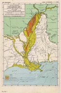
Full Title
Plate 1 Physiographic Map Central Gulf Coast Plain.
List No
15845.001
Author
[Fisk, Harold N., 1908-1964, Mississippi River Commission]
Full Title
Plate 2 Sheet 1 Alluvial Valley of the Mississippi River. Development of the Alluvial Surface.
List No
15845.002
Author
[Fisk, Harold N., 1908-1964, Mississippi River Commission]
Full Title
Plate 2 Sheet 2 Alluvial Valley of the Mississippi River. Development of the Alluvial Surface.
List No
15845.003
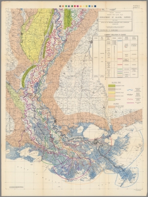
Author
[Fisk, Harold N., 1908-1964, Mississippi River Commission]
Full Title
(Composite map of) Plate 2 Sheets 1-2 Alluvial Valley of the Mississippi River. Development of the Alluvial Surface.
List No
15845.004
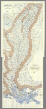
Author
[Fisk, Harold N., 1908-1964, Mississippi River Commission]
Full Title
Plate 3 Sheet 1 Alluvial Valley of the Mississippi River. Entrenched Valley System.
List No
15845.005
Author
[Fisk, Harold N., 1908-1964, Mississippi River Commission]
Full Title
Plate 3 Sheet 2 Alluvial Valley of the Mississippi River. Entrenched Valley System.
List No
15845.006
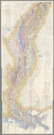
Author
[Fisk, Harold N., 1908-1964, Mississippi River Commission]
Full Title
(Composite map of) Plate 3 Sheets 1-2 Alluvial Valley of the Mississippi River. Entrenched Valley System.
List No
15845.007
Author
[Fisk, Harold N., 1908-1964, Mississippi River Commission]
Full Title
Plate 10 Sheet 1 Alluvial Valley of the Mississippi River. Geological Map Alluvial Valley Floor.
List No
15845.008
Author
[Fisk, Harold N., 1908-1964, Mississippi River Commission]
Full Title
Plate 10 Sheet 2 Alluvial Valley of the Mississippi River. Geological Map Alluvial Valley Floor.
List No
15845.009
Author
[Fisk, Harold N., 1908-1964, Mississippi River Commission]
Full Title
(Composite map of) Plate 10 Sheets 1-2 Alluvial Valley of the Mississippi River. Geological Map Alluvial Valley Floor.
List No
15845.010
Author
[Fisk, Harold N., 1908-1964, Mississippi River Commission]
Full Title
Plate 12 Sheet 1 Alluvial Valley of the Mississippi River. Top of Graveliferous Alluvium.
List No
15845.011
Author
[Fisk, Harold N., 1908-1964, Mississippi River Commission]
Full Title
Plate 12 Sheet 2 Alluvial Valley of the Mississippi River. Top of Graveliferous Alluvium.
List No
15845.012
Author
[Fisk, Harold N., 1908-1964, Mississippi River Commission]
Full Title
(Composite map of) Plate 12 Sheets 1-2 Alluvial Valley of the Mississippi River. Top of Graveliferous Alluvium.
List No
15845.013
Author
[Fisk, Harold N., 1908-1964, Mississippi River Commission]
Full Title
Plate 15 Sheet 1 Alluvial Valley of the Mississippi River. Stream Courses.
List No
15845.014
Author
[Fisk, Harold N., 1908-1964, Mississippi River Commission]
Full Title
Plate 15 Sheet 2 Alluvial Valley of the Mississippi River. Stream Courses.
List No
15845.015
Author
[Fisk, Harold N., 1908-1964, Mississippi River Commission]
Full Title
Plate 15 Sheet 3 Alluvial Valley of the Mississippi River. Stream Courses.
List No
15845.016
Author
[Fisk, Harold N., 1908-1964, Mississippi River Commission]
Full Title
Plate 15 Sheet 4 Alluvial Valley of the Mississippi River. Stream Courses.
List No
15845.017
Author
[Fisk, Harold N., 1908-1964, Mississippi River Commission]
Full Title
(Composite map of) Plate 15 Sheets 1- 4 Alluvial Valley of the Mississippi River. Stream Courses.
List No
15845.018
Author
[Fisk, Harold N., 1908-1964, Mississippi River Commission]
Full Title
Plate 22 Sheet 1 Alluvial Valley of the Mississippi River. Ancient Courses Mississippi River Meander Belt. Cape Girardeau, Mo. - Donaldsonville, LA.
List No
15845.019
Author
[Fisk, Harold N., 1908-1964, Mississippi River Commission]
Full Title
Plate 22 Sheet 2 Alluvial Valley of the Mississippi River. Ancient Courses Mississippi River Meander Belt. Cape Girardeau, Mo. - Donaldsonville, LA.
List No
15845.020
Author
[Fisk, Harold N., 1908-1964, Mississippi River Commission]
Full Title
Plate 22 Sheet 3 Alluvial Valley of the Mississippi River. Ancient Courses Mississippi River Meander Belt. Cape Girardeau, Mo. - Donaldsonville, LA.
List No
15845.021
Author
[Fisk, Harold N., 1908-1964, Mississippi River Commission]
Full Title
Plate 22 Sheet 4 Alluvial Valley of the Mississippi River. Ancient Courses Mississippi River Meander Belt. Cape Girardeau, Mo. - Donaldsonville, LA.
List No
15845.022
Author
[Fisk, Harold N., 1908-1964, Mississippi River Commission]
Full Title
Plate 22 Sheet 5 Alluvial Valley of the Mississippi River. Ancient Courses Mississippi River Meander Belt. Cape Girardeau, Mo. - Donaldsonville, LA.
List No
15845.023
Author
[Fisk, Harold N., 1908-1964, Mississippi River Commission]
Full Title
Plate 22 Sheet 6 Alluvial Valley of the Mississippi River. Ancient Courses Mississippi River Meander Belt. Cape Girardeau, Mo. - Donaldsonville, LA.
List No
15845.024
Author
[Fisk, Harold N., 1908-1964, Mississippi River Commission]
Full Title
Plate 22 Sheet 7 Alluvial Valley of the Mississippi River. Ancient Courses Mississippi River Meander Belt. Cape Girardeau, Mo. - Donaldsonville, LA.
List No
15845.025
Author
[Fisk, Harold N., 1908-1964, Mississippi River Commission]
Full Title
Plate 22 Sheet 8 Alluvial Valley of the Mississippi River. Ancient Courses Mississippi River Meander Belt. Cape Girardeau, Mo. - Donaldsonville, LA.
List No
15845.026
Author
[Fisk, Harold N., 1908-1964, Mississippi River Commission]
Full Title
Plate 22 Sheet 9 Alluvial Valley of the Mississippi River. Ancient Courses Mississippi River Meander Belt. Cape Girardeau, Mo. - Donaldsonville, LA.
List No
15845.027
Author
[Fisk, Harold N., 1908-1964, Mississippi River Commission]
Full Title
Plate 22 Sheet 10 Alluvial Valley of the Mississippi River. Ancient Courses Mississippi River Meander Belt. Cape Girardeau, Mo. - Donaldsonville, LA.
List No
15845.028
Author
[Fisk, Harold N., 1908-1964, Mississippi River Commission]
Full Title
Plate 22 Sheet 11 Alluvial Valley of the Mississippi River. Ancient Courses Mississippi River Meander Belt. Cape Girardeau, Mo. - Donaldsonville, LA.
List No
15845.029
Author
[Fisk, Harold N., 1908-1964, Mississippi River Commission]
Full Title
Plate 22 Sheet 12 Alluvial Valley of the Mississippi River. Ancient Courses Mississippi River Meander Belt. Cape Girardeau, Mo. - Donaldsonville, LA.
List No
15845.030
Author
[Fisk, Harold N., 1908-1964, Mississippi River Commission]
Full Title
Plate 22 Sheet 13 Alluvial Valley of the Mississippi River. Ancient Courses Mississippi River Meander Belt. Cape Girardeau, Mo. - Donaldsonville, LA.
List No
15845.031
Author
[Fisk, Harold N., 1908-1964, Mississippi River Commission]
Full Title
Plate 22 Sheet 14 Alluvial Valley of the Mississippi River. Ancient Courses Mississippi River Meander Belt. Cape Girardeau, Mo. - Donaldsonville, LA.
List No
15845.032
Author
[Fisk, Harold N., 1908-1964, Mississippi River Commission]
Full Title
Plate 22 Sheet 15 Alluvial Valley of the Mississippi River. Ancient Courses Mississippi River Meander Belt. Cape Girardeau, Mo. - Donaldsonville, LA.
List No
15845.033
Author
[Fisk, Harold N., 1908-1964, Mississippi River Commission]
Full Title
(Composite map of) Plate 22 Sheets 1-15 Alluvial Valley of the Mississippi River. Ancient Courses Mississippi River Meander Belt. Cape Girardeau, Mo. - Donaldsonville, LA.
List No
15845.034
Note
To view this map in desktop Google Earth, install Google Earth Pro, download this link and open it in Google Earth by double clicking on the file.
https://rumseygeo.s3.amazonaws.com/15845035mercator2/doc.kml
Author
Russell, Israel C. (Israel Cook), 1852-1906.
Full Title
Lake Lahontan : a quaternary lake of northwestern Nevad, by Israel C. Russell. Assisted by A.L. Webster, W.D. Johnson, cartographers ; W.J. McGee. GEO. M. Wright, geologists. Mountain shading, by W.J. Hays. Topography compiled by Eugene Rickseker ... (to accompany) Geological history of Lake Lahontan : a quaternary lake of Northwestern Nevada. (series title) Department of Interior : Monographs of the United States Geological Survey, vol. XI. (on upper margin) U.S. Geological Survey; Lake Lahontan PL. XLVI.
List No
0866.051
Note
Color map. Showing quaternary lakes, existing lakes and playas. Relief shown by contours and shadings. "Contours 1000 feet interval". Shows footprint of buildings and railroads.
Author
[USGS (U.S. Geological Survey), Walcott, Charles D., Gannett, Henry]
Full Title
Plate CXXVIII. Roseburg Quadrangle, Oregon, Land Classification and Density of Standing Timber.
List No
6322.169
Note
Color. Relief shown in contours.
Author
Russell, Israel C. (Israel Cook), 1852-1906.
Full Title
(Title Page to) Department of Interior : Monographs of the United States Geological Survey, vol. XI. House of Representative : 49th Congress, 1st Session. Mis. Doc. No. 304. Washington : Government printing Office 1885. Geological history of Lake Lahontan : a quaternary lake of Northwestern Nevada ; by Israel Cook Russell. (at head to title) United States Geological Survey; J.W. Powell, Director.
List No
0866.001
Note
Geological history of Lake Lahontan, published in U.S.G.S. Monograph vol. 11. Includes maps, views, diagrams, cross-sections and tables.
Author
Russell, Israel C. (Israel Cook), 1852-1906.
Full Title
(Title Page to) Geological history of Lake Lahontan : a quaternary lake of Northwestern Nevada ; by Israel Cook Russell. (at head to title) United States Geological Survey; J.W. Powell, Director. (series title) Department of Interior : Monographs of the United States Geological Survey, vol. XI. House of Representative : 49th Congress, 1st Session. Mis. Doc. No. 304. Washington : Government printing Office 1885.
List No
0866.002
Note
Geological history of Lake Lahontan, published in U.S.G.S. Monograph vol. 11. Includes maps, views, diagrams, cross-sections and tables.
Author
Russell, Israel C. (Israel Cook), 1852-1906.
Full Title
Quaternary lakes of the Great Basin. Julius Bien & Co. Lith. (to accompany) Geological history of Lake Lahontan : a quaternary lake of Northwestern Nevada. (series title) Department of Interior : Monographs of the United States Geological Survey, vol. XI. (on upper margin) U.S. Geological Survey; Lake Lahontan PL. I.
List No
0866.003
Note
Color map. Shows lake, rivers and major cities. Depth shown by isolines.
Author
Russell, Israel C. (Israel Cook), 1852-1906.
Full Title
Routes traveled and areas surveyed. Julius Bien & Co. Lith. (to accompany) Geological history of Lake Lahontan : a quaternary lake of Northwestern Nevada. (series title) Department of Interior : Monographs of the United States Geological Survey, vol. XI. (on upper margin) U.S. Geological Survey; Lake Lahontan PL. II.
List No
0866.004
Note
Color map. Shows lake, rivers, routes explored by I.C. Russell and scientific assistants. Areas survey marked in blue. Relief shown by shadings. Depth shown by isolines.
Author
Russell, Israel C. (Israel Cook), 1852-1906.
Full Title
Pre-Quternary fault lines. Julius Bien & Co. Lith. (to accompany) Geological history of Lake Lahontan : a quaternary lake of Northwestern Nevada. (series title) Department of Interior : Monographs of the United States Geological Survey, vol. XI. (on upper margin) U.S. Geological Survey; Lake Lahontan PL. III.
List No
0866.005
Note
Color map. Shows lake and rivers. Fault lines shown in red. Relief shown by shadings. Depth shown by isolines.
Author
Russell, Israel C. (Israel Cook), 1852-1906.
Full Title
Map of Lake Lahontan : showing water area and boundary of hydrographic basin by Israel C. Russell. Julius Bien & Co. Lith. (to accompany) Geological history of Lake Lahontan : a quaternary lake of Northwestern Nevada. (series title) Department of Interior : Monographs of the United States Geological Survey, vol. XI. (on upper margin) U.S. Geological Survey; Lake Lahontan PL. IV.
List No
0866.006
Note
Color map. Includes legend. Relief shown by shadings. Depth shown by isolines.
Author
Russell, Israel C. (Israel Cook), 1852-1906.
Full Title
Depth of Lake Lahontan at highest water stage. Julius Bien & Co. Lith. (to accompany) Geological history of Lake Lahontan : a quaternary lake of Northwestern Nevada. (series title) Department of Interior : Monographs of the United States Geological Survey, vol. XI. (on upper margin) U.S. Geological Survey; Lake Lahontan PL. V.
List No
0866.007
Note
Color map. Relief shown by shadings. Depth shown by isolines and soundings in feet.
Author
Russell, Israel C. (Israel Cook), 1852-1906.
Full Title
Map showing land classification of Lahontan Region. Julius Bien & Co. Lith. (to accompany) Geological history of Lake Lahontan : a quaternary lake of Northwestern Nevada. (series title) Department of Interior : Monographs of the United States Geological Survey, vol. XI. (on upper margin) U.S. Geological Survey; Lake Lahontan PL. VI.
List No
0866.008
Note
Color map. Relief shown by shadings. Depth shown by isolines.
Author
Russell, Israel C. (Israel Cook), 1852-1906.
Full Title
Carson Desert, Nevada. Julius Bien & Co. Lith. (to accompany) Geological history of Lake Lahontan : a quaternary lake of Northwestern Nevada. (series title) Department of Interior : Monographs of the United States Geological Survey, vol. XI. (on upper margin) U.S. Geological Survey; Lake Lahontan PL. VII.
List No
0866.009
Note
Color map. Shows railroad, rivers and lakes. Relief shown by contours and shadings. "Interval between countours 1000 feet".
Author
Russell, Israel C. (Israel Cook), 1852-1906.
Full Title
Springs of the Lahontan Region. Julius Bien & Co. Lith. (to accompany) Geological history of Lake Lahontan : a quaternary lake of Northwestern Nevada. (series title) Department of Interior : Monographs of the United States Geological Survey, vol. XI. (on upper margin) U.S. Geological Survey; Lake Lahontan PL. VIII.
List No
0866.010
Note
Color map. Shows Existing springs, railroad, rivers, lakes and temperature in Farenheit. Relief shown by shadings.
Author
Russell, Israel C. (Israel Cook), 1852-1906.
Full Title
Pyramid and Winnemucca Lakes, Nevada. W.D. Johnson, Topograper. I.C. Russell, Geologist. (to accompany) Geological history of Lake Lahontan : a quaternary lake of Northwestern Nevada. (series title) Department of Interior : Monographs of the United States Geological Survey, vol. XI. (on upper margin) U.S. Geological Survey; Lake Lahontan PL. IX.
List No
0866.011
Note
Uncolored map. Relief shown by hachures. Depth shown by isolines and soundings in feet.
Author
Russell, Israel C. (Israel Cook), 1852-1906.
Full Title
Anaho Island, Pyramid Lake, Nevada. W.D. Johnson, Topograper. I.C. Russell, Geologist. (to accompany) Geological history of Lake Lahontan : a quaternary lake of Northwestern Nevada. (series title) Department of Interior : Monographs of the United States Geological Survey, vol. XI. (on upper margin) U.S. Geological Survey; Lake Lahontan PL. X.
List No
0866.012
Note
Uncolored map. Relief shown by hachures. Depth shown by soundings in feet.
Author
Russell, Israel C. (Israel Cook), 1852-1906.
Full Title
Sketch of Pyramid Island, Pyramid Lake, Nevada. (to accompany) Geological history of Lake Lahontan : a quaternary lake of Northwestern Nevada. (series title) Department of Interior : Monographs of the United States Geological Survey, vol. XI. (on upper margin) U.S. Geological Survey; Lake Lahontan PL. XI.
List No
0866.013
Note
Uncolored view of Pyramid Island.
Author
Russell, Israel C. (Israel Cook), 1852-1906.
Full Title
The Needles, Pyramid Lake, Nevada. (to accompany) Geological history of Lake Lahontan : a quaternary lake of Northwestern Nevada. (series title) Department of Interior : Monographs of the United States Geological Survey, vol. XI. (on upper margin) U.S. Geological Survey; Lake Lahontan PL. XII.
List No
0866.014
Note
Uncolored view of the Needles at the north end of Pyramid Lake.
Author
Russell, Israel C. (Israel Cook), 1852-1906.
Full Title
Among the Needles, Pyramid Lake, Nevada. (to accompany) Geological history of Lake Lahontan : a quaternary lake of Northwestern Nevada. (series title) Department of Interior : Monographs of the United States Geological Survey, vol. XI. (on upper margin) U.S. Geological Survey; Lake Lahontan PL. XIII.
List No
0866.015
Note
Uncolored view of the Needles at the north end of Pyramid Lake.
Author
Russell, Israel C. (Israel Cook), 1852-1906.
Full Title
Mushroom Rock, north shore of Anaho Island. (to accompany) Geological history of Lake Lahontan : a quaternary lake of Northwestern Nevada. (series title) Department of Interior : Monographs of the United States Geological Survey, vol. XI. (on upper margin) U.S. Geological Survey; Lake Lahontan PL. XIV.
List No
0866.016
Note
Uncolored view of Mushroom Rock.
Author
Russell, Israel C. (Israel Cook), 1852-1906.
Full Title
Walker Lake, Nevada. W.D. Johnson, Topographer. I.C. Russell, Geologist. (to accompany) Geological history of Lake Lahontan : a quaternary lake of Northwestern Nevada. (series title) Department of Interior : Monographs of the United States Geological Survey, vol. XI. (on upper margin) U.S. Geological Survey; Lake Lahontan PL. XV.
List No
0866.017
Note
Uncolored map. Relief shown by hachures. Depth shown by isolines and soundings in feet.
Author
Russell, Israel C. (Israel Cook), 1852-1906.
Full Title
Soda Lakes near Ragtown, Nevada. W.D. Johnson, Topographer. I.C. Russell, Geologist. (to accompany) Geological history of Lake Lahontan : a quaternary lake of Northwestern Nevada. (series title) Department of Interior : Monographs of the United States Geological Survey, vol. XI. (with inset).
List No
0866.018
Note
Color map, with inset of vertical profile of Soda Lake. Relief shown by contours. Depth shown by isolines and soundings in feet. "Contours 20 feet apart".
Author
Russell, Israel C. (Israel Cook), 1852-1906.
Full Title
Section of the crater walls inclosing the Soda Lakes, Nevada. W.J. McGee. Del. I.C. Russell, Geologist. (to accompany) Geological history of Lake Lahontan : a quaternary lake of Northwestern Nevada. (series title) Department of Interior : Monographs of the United States Geological Survey, vol. XI. (on upper margin) U.S. Geological Survey; Lake Lahontan PL. XVII.
List No
0866.019
Note
5 uncolored geologic cross-section of Soda Lakes.
Author
Russell, Israel C. (Israel Cook), 1852-1906.
Full Title
Gravel embarkments at west end of Humboldt Lake, Nevada. W.D. Johnson. Topographer. I.C. Russell, Geologist. (to accompany) Geological history of Lake Lahontan : a quaternary lake of Northwestern Nevada. (series title) Department of Interior : Monographs of the United States Geological Survey, vol. XI. (on upper margin) U.S. Geological Survey; Lake Lahontan PL. XVIII.
List No
0866.020
Note
Uncolored map, with inset vertical profile of Humboldt Lake. Shows railroads. Relief shown by hachures. Depth shown by soundings.
Author
Russell, Israel C. (Israel Cook), 1852-1906.
Full Title
Gravel embarkments on south border of the Carson Desert, Nevada. W.D. Johnson. Topographer. I.C. Russell, Geologist. (to accompany) Geological history of Lake Lahontan : a quaternary lake of Northwestern Nevada. (series title) Department of Interior : Monographs of the United States Geological Survey, vol. XI. (on upper margin) U.S. Geological Survey; Lake Lahontan PL. XIX.
List No
0866.021
Note
Uncolored map. Shows railroads. Relief shown by hachures.
Author
Russell, Israel C. (Israel Cook), 1852-1906.
Full Title
Gravel embarkments at Buffalo Springs, Nevada. W.D. Johnson. Topographer. I.C. Russell, Geologist. (to accompany) Geological history of Lake Lahontan : a quaternary lake of Northwestern Nevada. (series title) Department of Interior : Monographs of the United States Geological Survey, vol. XI. (on upper margin) U.S. Geological Survey; Lake Lahontan PL. XX.
List No
0866.022
Note
Uncolored map. Depth shown by soundings.
Author
Russell, Israel C. (Israel Cook), 1852-1906.
Full Title
Gravel embarkments three miles south of Buffalo Springs, Nevada. W.D. Johnson. Topographer. I.C. Russell, Geologist. (to accompany) Geological history of Lake Lahontan : a quaternary lake of Northwestern Nevada. (series title) Department of Interior : Monographs of the United States Geological Survey, vol. XI. (on upper margin) U.S. Geological Survey; Lake Lahontan PL. XXI.
List No
0866.023
Note
Uncolored map. Depth shown by soundings.
Author
Russell, Israel C. (Israel Cook), 1852-1906.
Full Title
Lahontan sediments, Humboldt Canon, near Rye Patch, Nevada.(to accompany) Geological history of Lake Lahontan : a quaternary lake of Northwestern Nevada. (series title) Department of Interior : Monographs of the United States Geological Survey, vol. XI. (on upper margin) U.S. Geological Survey; Lake Lahontan PL. XXII.
List No
0866.024
Note
Uncolored view.
Author
Russell, Israel C. (Israel Cook), 1852-1906.
Full Title
Section of Lahontan sediments in Humboldt Canon, Nevada. W.J. McGee, Del. I.C. Russell, Geologist. (to accompany) Geological history of Lake Lahontan : a quaternary lake of Northwestern Nevada. (series title) Department of Interior : Monographs of the United States Geological Survey, vol. XI. (on upper margin) U.S. Geological Survey; Lake Lahontan PL. XXIII.
List No
0866.025
Note
9 uncolored geologic cross-sections.
Author
Russell, Israel C. (Israel Cook), 1852-1906.
Full Title
Section of Lahontan sediments in Humboldt Canon, Nevada. W.J. McGee, Del. I.C. Russell, Geologist. (to accompany) Geological history of Lake Lahontan : a quaternary lake of Northwestern Nevada. (series title) Department of Interior : Monographs of the United States Geological Survey, vol. XI. (on upper margin) U.S. Geological Survey; Lake Lahontan PL. XXIV.
List No
0866.026
Note
9 uncolored geologic cross-sections.
Author
Russell, Israel C. (Israel Cook), 1852-1906.
Full Title
Section of Lahontan sediments near Agency Bridge, Truckee Canon, Nevada. W.J. McGee, Del. I.C. Russell, Geologist. (to accompany) Geological history of Lake Lahontan : a quaternary lake of Northwestern Nevada. (series title) Department of Interior : Monographs of the United States Geological Survey, vol. XI. (on upper margin) U.S. Geological Survey; Lake Lahontan PL. XXV.
List No
0866.027
Note
Uncolored geologic cross-section.
Author
Russell, Israel C. (Israel Cook), 1852-1906.
Full Title
Section of Lahontan sediments, Agency Bridge, Truckee River, Nevada. (to accompany) Geological history of Lake Lahontan : a quaternary lake of Northwestern Nevada. (series title) Department of Interior : Monographs of the United States Geological Survey, vol. XI. (on upper margin) U.S. Geological Survey; Lake Lahontan PL.XXVI.
List No
0866.028
Note
Uncolored geologic cross-section.
Author
Russell, Israel C. (Israel Cook), 1852-1906.
Full Title
Detailed section of Lahontan sediments, Truckee Canon, Nevada. W.J. McGee, Del. I.C. Russell, Geologist. (to accompany) Geological history of Lake Lahontan : a quaternary lake of Northwestern Nevada. (series title) Department of Interior : Monographs of the United States Geological Survey, vol. XI. (on upper margin) U.S. Geological Survey; Lake Lahontan PL.XXVII.
List No
0866.029
Note
4 uncolored geologic cross-section.
Author
Russell, Israel C. (Israel Cook), 1852-1906.
Full Title
Detailed section of Lahontan sediments in Walker Canon, Nevada. W.J. McGee, Del. I.C. Russell, Geologist. (to accompany) Geological history of Lake Lahontan : a quaternary lake of Northwestern Nevada. (series title) Department of Interior : Monographs of the United States Geological Survey, vol. XI. (on upper margin) U.S. Geological Survey; Lake Lahontan PL.XXVIII.
List No
0866.030
Note
3 uncolored geologic cross-section.
Author
Russell, Israel C. (Israel Cook), 1852-1906.
Full Title
Present drainage areas of the Lahontan Region. Julius Bien & Co. Lith. (to accompany) Geological history of Lake Lahontan : a quaternary lake of Northwestern Nevada. (series title) Department of Interior : Monographs of the United States Geological Survey, vol. XI. (on upper margin) U.S. Geological Survey; Lake Lahontan PL.XXIX.
List No
0866.031
Note
Color map. Relief shown by contours. Depth shown by isolines. Hydrographic boundaries shown in red.
Author
Russell, Israel C. (Israel Cook), 1852-1906.
Full Title
(Statistical Table to) Table A.- Analyses of American River waters. Reduced to parts per 1,000 by Dr. H.J. Von Hoesen. (to accompany) Geological history of Lake Lahontan : a quaternary lake of Northwestern Nevada. (series title) Department of Interior : Monographs of the United States Geological Survey, vol. XI.
List No
0866.032
Note
Table includes name of river, dates, name of analyst, and list of minerals.
Author
Russell, Israel C. (Israel Cook), 1852-1906.
Full Title
(Statistical Table to) Table B.- Analyses of American spring waters. Reduced to parts per 1,000 by Dr. H.J. Von Hoesen. (to accompany) Geological history of Lake Lahontan : a quaternary lake of Northwestern Nevada. (series title) Department of Interior : Monographs of the United States Geological Survey, vol. XI.
List No
0866.033
Note
Table includes name of river, dates, name of analyst, and list of minerals.
Author
Russell, Israel C. (Israel Cook), 1852-1906.
Full Title
(Statistical Table to) Table C.- Analyses of the waters of enclosed lakes. Reduced to parts per 1,000 by Dr. H.J. Von Hoesen. (to accompany) Geological history of Lake Lahontan : a quaternary lake of Northwestern Nevada. (series title) Department of Interior : Monographs of the United States Geological Survey, vol. XI.
List No
0866.034
Note
Table includes name of lakes, dates, name and average of analyst, and list of minerals.
Author
Russell, Israel C. (Israel Cook), 1852-1906.
Full Title
Tufa Crag at Allen's Spring, Nevada, showing successive deposits. (to accompany) Geological history of Lake Lahontan : a quaternary lake of Northwestern Nevada. (series title) Department of Interior : Monographs of the United States Geological Survey, vol. XI. (on upper margin) U.S. Geological Survey; Lake Lahontan PL. XXX.
List No
0866.035
Note
Uncolored view.
Author
Russell, Israel C. (Israel Cook), 1852-1906.
Full Title
Water surface on Lake Lahontan at thinolite stage. Juliud Bien & Co. Lith. (to accompany) Geological history of Lake Lahontan : a quaternary lake of Northwestern Nevada. (series title) Department of Interior : Monographs of the United States Geological Survey, vol. XI. (on upper margin) U.S. Geological Survey; Lake Lahontan PL. XXXI.
List No
0866.036
Note
Color map. Shows railroad. Relief shown by contours and shadings. Depth shown by isolines.
Author
Russell, Israel C. (Israel Cook), 1852-1906.
Full Title
A characteristic specimen of thinolite. (to accompany) Geological history of Lake Lahontan : a quaternary lake of Northwestern Nevada. (series title) Department of Interior : Monographs of the United States Geological Survey, vol. XI. (on upper margin) U.S. Geological Survey; Lake Lahontan PL. XXXII.
List No
0866.037
Note
Uncolored view
Author
Russell, Israel C. (Israel Cook), 1852-1906.
Full Title
Illustrations of the structure of thinolite. (to accompany) Geological history of Lake Lahontan : a quaternary lake of Northwestern Nevada. (series title) Department of Interior : Monographs of the United States Geological Survey, vol. XI. (on upper margin) U.S. Geological Survey; Lake Lahontan PL. XXXIII.
List No
0866.038
Note
38 uncolored views of thinolite crystals from Pyramid Lake, Mono Lake, Black Rock Desert, etc.
Author
Russell, Israel C. (Israel Cook), 1852-1906.
Full Title
Illustrations of the structure of thinolite. (to accompany) Geological history of Lake Lahontan : a quaternary lake of Northwestern Nevada. (series title) Department of Interior : Monographs of the United States Geological Survey, vol. XI. (on upper margin) U.S. Geological Survey; Lake Lahontan PL. XXXIV.
List No
0866.039
Note
38 uncolored views of thinolite crystals from Pyramid Lake, Mono Lake, Black Rock Desert, etc.
Author
Russell, Israel C. (Israel Cook), 1852-1906.
Full Title
A characteristic specimen of dendritic Tufa. (to accompany) Geological history of Lake Lahontan : a quaternary lake of Northwestern Nevada. (series title) Department of Interior : Monographs of the United States Geological Survey, vol. XI. (on upper margin) U.S. Geological Survey; Lake Lahontan PL. XXXV.
List No
0866.040
Note
Uncolored view.
Author
Russell, Israel C. (Israel Cook), 1852-1906.
Full Title
Dendritic Tufa deposited on a cliff. (to accompany) Geological history of Lake Lahontan : a quaternary lake of Northwestern Nevada. (series title) Department of Interior : Monographs of the United States Geological Survey, vol. XI. (on upper margin) U.S. Geological Survey; Lake Lahontan PL. XXXVI.
List No
0866.041
Note
Uncolored view.
Author
Russell, Israel C. (Israel Cook), 1852-1906.
Full Title
Imitative Tufa forms. (to accompany) Geological history of Lake Lahontan : a quaternary lake of Northwestern Nevada. (series title) Department of Interior : Monographs of the United States Geological Survey, vol. XI. (on upper margin) U.S. Geological Survey; Lake Lahontan PL. XXXVII.
List No
0866.042
Note
Uncolored view.
Author
Russell, Israel C. (Israel Cook), 1852-1906.
Full Title
An island of Tufa in Pyramid Lake, Nevada. (to accompany) Geological history of Lake Lahontan : a quaternary lake of Northwestern Nevada. (series title) Department of Interior : Monographs of the United States Geological Survey, vol. XI. (on upper margin) U.S. Geological Survey; Lake Lahontan PL. XXXVIII.
List No
0866.043
Note
Uncolored view.
Author
Russell, Israel C. (Israel Cook), 1852-1906.
Full Title
Tufa towers on the shore of Pyramid Lake, Nevada. (to accompany) Geological history of Lake Lahontan : a quaternary lake of Northwestern Nevada. (series title) Department of Interior : Monographs of the United States Geological Survey, vol. XI. (on upper margin) U.S. Geological Survey; Lake Lahontan PL. XXXIX.
List No
0866.044
Note
Uncolored view.
Author
Russell, Israel C. (Israel Cook), 1852-1906.
Full Title
Tufa castle, west of Pyramid Lake, Nevada. (to accompany) Geological history of Lake Lahontan : a quaternary lake of Northwestern Nevada. (series title) Department of Interior : Monographs of the United States Geological Survey, vol. XI. (on upper margin) U.S. Geological Survey; Lake Lahontan PL. XL.
List No
0866.045
Note
Uncolored view.
Author
Russell, Israel C. (Israel Cook), 1852-1906.
Full Title
Tufa domes in Pyramid Lake, Nevada. (to accompany) Geological history of Lake Lahontan : a quaternary lake of Northwestern Nevada. (series title) Department of Interior : Monographs of the United States Geological Survey, vol. XI. (on upper margin) U.S. Geological Survey; Lake Lahontan PL. XLI.
List No
0866.046
Note
Uncolored view.
Author
Russell, Israel C. (Israel Cook), 1852-1906.
Full Title
Tufa tower on the shore of Winnemucca Lake, Nevada. (to accompany) Geological history of Lake Lahontan : a quaternary lake of Northwestern Nevada. (series title) Department of Interior : Monographs of the United States Geological Survey, vol. XI. (on upper margin) U.S. Geological Survey; Lake Lahontan PL. XLII.
List No
0866.047
Note
Uncolored view.
Author
Russell, Israel C. (Israel Cook), 1852-1906.
Full Title
Tufa domes in Mono Lake, California. (to accompany) Geological history of Lake Lahontan : a quaternary lake of Northwestern Nevada. (series title) Department of Interior : Monographs of the United States Geological Survey, vol. XI. (on upper margin) U.S. Geological Survey; Lake Lahontan PL. XLIII.
List No
0866.048
Note
Uncolored view.
Author
Russell, Israel C. (Israel Cook), 1852-1906.
Full Title
Post - quaternary fault lines. Julius Bien & Co. Lith. (to accompany) Geological history of Lake Lahontan : a quaternary lake of Northwestern Nevada. (series title) Department of Interior : Monographs of the United States Geological Survey, vol. XI. (on upper margin) U.S. Geological Survey; Lake Lahontan PL. XLIV.
List No
0866.049
Note
Color map. Shows railroads. Fault lines shown in red. Relief shown by contours and shadings. Depth shown by isolines.
Author
Russell, Israel C. (Israel Cook), 1852-1906.
Full Title
Post - quaternary fault on the south shore of Humboldt Lake. (to accompany) Geological history of Lake Lahontan : a quaternary lake of Northwestern Nevada. (series title) Department of Interior : Monographs of the United States Geological Survey, vol. XI. (on upper margin) U.S. Geological Survey; Lake Lahontan PL. XLV.
List No
0866.050
Note
Uncolored view.
Author
Dutton, Clarence E. (Clarence Edward), 1841-1912
Full Title
(Covers to) Tertiary History of the Grand Canon District With Atlas by Clarence E. Dutton, Captain of Ordnance U.S.A. United States Geological Survey, J.W. Powell, Director. Washington: Government Printing Office 1882. Department of the Interior. Monographs of the United States Geological Survey, Volume II. Washington: Government Printing Office 1882.
List No
2147.001
Note
Bound in brown linen covered boards with "U.S. Geological Survey, J.W. Powell, Director. Monographs II, Dutton. Tertiary History of the Grand Canon District" on the spine in gold.
Author
Dutton, Clarence E. (Clarence Edward), 1841-1912
Full Title
(Advertisement for) (U.S. Geological Survey Reports.)
List No
2147.002
Author
Dutton, Clarence E. (Clarence Edward), 1841-1912
Full Title
(Half Title Page) Department of the Interior. Monographs of the United States Geological Survey, Volume II. Washington: Government Printing Office 1882.
List No
2147.003
Author
Dutton, Clarence E. (Clarence Edward), 1841-1912
Full Title
(Frontispiece and View) Pl. I. Smithsonian Butte - Valley of the Virgen (Virgin).
List No
2147.004
Author
Dutton, Clarence E. (Clarence Edward), 1841-1912
Full Title
(Title Page) Tertiary History of the Grand Canon District With Atlas by Clarence E. Dutton, Captain of Ordnance U.S.A. United States Geological Survey, J.W. Powell, Director. Washington: Government Printing Office 1882. Department of the Interior. Monographs of the United States Geological Survey, Volume II. Washington: Government Printing Office 1882.
List No
2147.005
Author
Dutton, Clarence E. (Clarence Edward), 1841-1912
Full Title
(Text Page) (Letter of Conveyance to) Hon. Clarence King.
List No
2147.006
Author
Dutton, Clarence E. (Clarence Edward), 1841-1912
Full Title
(Text Page) Preface.
List No
2147.007
Author
Dutton, Clarence E. (Clarence Edward), 1841-1912
Full Title
(Text Page) Preface (continued).
List No
2147.008
Author
Dutton, Clarence E. (Clarence Edward), 1841-1912
Full Title
(Index Page) Contents.
List No
2147.009
Author
Dutton, Clarence E. (Clarence Edward), 1841-1912
Full Title
(Index Page) Contents (continued).
List No
2147.010
Author
Dutton, Clarence E. (Clarence Edward), 1841-1912
Full Title
(Index Page) Contents (continued).
List No
2147.011
Author
Dutton, Clarence E. (Clarence Edward), 1841-1912
Full Title
(Text Page) The Tertiary History of the Grand Canyon District. By Clarence E. Dutton. Abstract of the Monograph.
List No
2147.012
Author
Dutton, Clarence E. (Clarence Edward), 1841-1912
Full Title
(Text Page) The Tertiary History of the Grand Canyon District. By Clarence E. Dutton. Abstract of the Monograph (continued).
List No
2147.013
Author
Dutton, Clarence E. (Clarence Edward), 1841-1912
Full Title
(Text Page) The Tertiary History of the Grand Canyon District. By Clarence E. Dutton. Abstract of the Monograph (continued).
List No
2147.014
|