|
Author
[Anonymous, Bey, Abdürrahim Hilmi]
Full Title
[Without Title. Geological Structure of the Earth, Fossils and Evolution of Amimals]
List No
10739.029
Note
The image with a subject of the geological structure of the earth and the evolution of animals is composed from a colour drawing and two hand coloured black and white photographs. The central image represents the earth’s structure and is partly based on the broadside اراض و صنوف مختلفه صخورك جدول عهق ملسى [Presentation of Various Soils and Types of Rocks], an Ottoman colour lithograph from circa 1900, issued for educational purposes. The image remains unfinished in the lower corners. The left side panel represents fossils and dinosaurs and the right one the evolution of animals though geologic periods. Both images are photographic reproductions of illustrations from publications, hand-coloured by the author and accompanied by hand-written annotations.
Author
Heck, Johann Georg, -1857
Full Title
(View) Plate 44. (Geology: Landforms).
List No
12190.077
Author
[Hackman, R.J., U.S. Geological Survey]
Full Title
Geologic Map and Sections of the Kepler Region of the Moon. MAP I - 355 (LAC-57).
List No
12101.002
Author
[Marshall, C.H., U.S. Geological Survey]
Full Title
Geologic Map and Sections of the Letronne Region of the Moon. MAP I - 385 (LAC-75).
List No
12101.004
Author
[Ewald, Ludwig 1813-1881, Bauerkeller, Georg Leonhart]
Full Title
(Geologic Cross-Section) No. 10. Geologische Elemente.
List No
12189.032
Author
King, Clarence
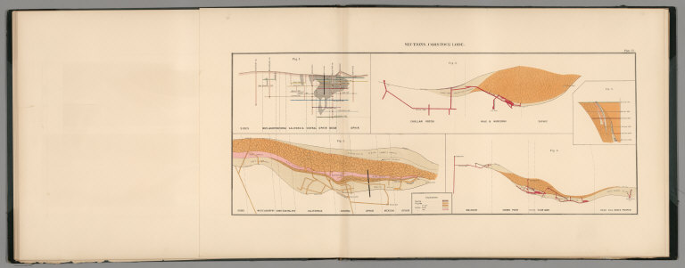
Full Title
Plate 6. Longitudinal Elevation Gold Hill Mines, Comstock Lode.
List No
0407.008
Author
King, Clarence
Full Title
Plate 7. Longitudinal Elevation Virginia Mines, Comstock Lode.
List No
0407.009
Note
Printed color and hand colored. Drifts or levels colored to correspond with depth.
Author
King, Clarence
Full Title
Plate 8. Cross Sections Gold Hill Mines, Comstock Lode.
List No
0407.010
Author
King, Clarence
Full Title
Plate 9. Cross Sections Virginia Mines, Comstock Lode.
List No
0407.011
Author
King, Clarence
Full Title
Plate 10. Cross Sections Virginia Mines, Comstock Lode.
List No
0407.012
Author
King, Clarence
Full Title
Plate 11. Cross Sections Virginia Mines, Comstock Lode.
List No
0407.013
Author
King, Clarence
Full Title
Plate 12. Sections, Comstock Lode.
List No
0407.014
Author
Malte-Brun, Conrad, 1775-1826
Full Title
Coupes Geologiques. Coupe des terraines entre Paris et Colmar. Coupes des terraines dans les Pyrenees. Coupe des terrains entre le Cumberland et Durham (angleterre.) Coupe des terrains dans le Derbyshire. No. 20bis. Grave par Thierry.
List No
0458.026
Note
Engraved. Geologic units listed and described in legend and depicted in full color. Cross-sections in northern France, Pyrenees, and England.
Author
Maury, Matthew Fontaine, 1806-1873
Full Title
XII. Vertical section - North Atlantic Ocean. Engraved & printed by J.M. Butler, Philada. (to accompany) The Physical Geography of the Sea. By M.F. Maury. An Entirely New Edition, With Addenda.
List No
0475.019
Note
Profile of the North Atlantic Ocean, showing the contrast of its bottom with the sea level in various regions.
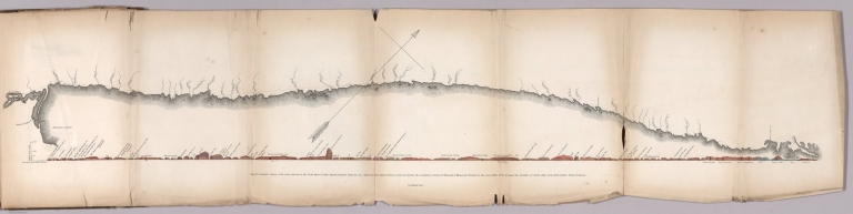
Author
Owen, David Dale
Full Title
General connected section of the rocks exposed on the North shore of Lake Superior between Fond du Lac Superieur and Pigeon Point, as observed during the geological surveys of Wisconsin & Minnesota territory, in the year 1848, 49 & 50, under the direction of David Dale Owen, M.D. United States Geologist. By Richard Owen. (to accompany) Illustrations to the Geological Report of Wisconsin, Iowa, and Minnesota. (with) Report of a Geological Survey of Wisconsin, Iowa and Minnesota ... 1852.
List No
0690.034
Note
Hand color geologic cross section on sheet 31x135 cm. folded to 31x20. with explanation of rock formations.
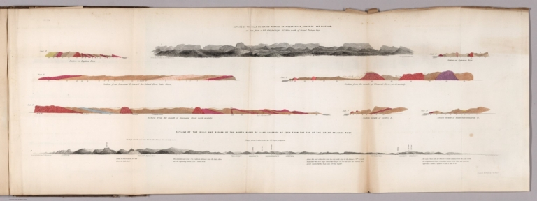
Author
Owen, David Dale
Full Title
Outline of the hills on Grand Portage of Pigeon River, North of Lake Superior: as seen from hill 650 feet high - 4 1/2 miles north of Grand Portage Bay. (with) Outline of the hills and ridges of the north shore of Lake Superior as seen from the top of the Great Palisade Rock. From an outline by J.G. Norwood. Engraved & printed by J.M. Butler. (to accompany) Illustrations to the Geological Report of Wisconsin, Iowa, and Minnesota. (with) Report of a Geological Survey of Wisconsin, Iowa and Minnesota ... 1852.
List No
0690.036
Note
Hand color geologic cross sections, folded to 31x21 cm., showing geologic formations. With 2 uncolored outline view of hills north shore of Lake Superior showing elevation in feet, Includes detail explanation. On upper right margin Pl. 1 N.
Author
Owen, David Dale
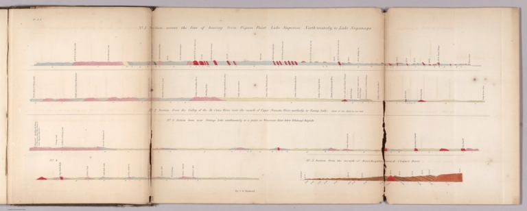
Full Title
No. 1: Section cross the line of bearing from Pigeon Point Lake Superior, North Westerly, to Lake Saganaga. No. 2: Section from the valley of the St. Croix River near the mount of Upper Pinnette River, northerly, to Rainy Lake. No. 3: Section from near Portage Lake southeasterly to a point on Wisconsin River below Whitney's Rapids. No. 4: (untitled: from Big Bull Falls to Whitney's Mill) No. 5: Section from the mouth of Kinechegakwag Cr. toward Cloquet River. by J.G. Norwood. Engraved & printed by J.M. Butler. (to accompany) Illustrations to the Geological Report of Wisconsin, Iowa, and Minnesota. (with) Report of a Geological Survey of Wisconsin, Iowa and Minnesota ... 1852.
List No
0690.037
Note
5 geologic cross sections, hand colored, folded to 31x21 cm. Includes detail explanation. On upper left margin Pl. 2 N.
Author
Owen, David Dale
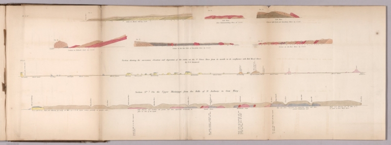
Full Title
Sec. 1. Section on Mission Creek, by J.G.N. Sec.2. Lake shore above Kamanasisatikag River, by J.G.N. Sec. 3. Lake shore between Split Rock and Gooseberry River, by J.G.N. Sec.4. Section of Palisade River, by J.G.N. Sec 4, S. Section showing the succession, elevation and depression of the rocks on the St. Peters River... By F. B. Shumard. Sec. 5. Section on the west fork of Palisade River, by J.G.N. Sec. 6. Section on Cut-Face River, by J.G.N. Section No. 7, on the upper Mississippi from the falls to St. Anthony to Corw Wing. (to accompany) Illustrations to the Geological Report of Wisconsin, Iowa, and Minnesota. (with) Report of a Geological Survey of Wisconsin, Iowa and Minnesota ... 1852.
List No
0690.038
Note
8 geologic cross sections, hand colored, folded to 31x21 cm. Includes detail explanation. On upper left margin Pl. 3 N.
Author
Owen, David Dale
Full Title
No.1. Section of the summit levels, showing the general elevation of the country between the mouth of Chippewa river and the mouth of Bad River, above lake Superior. No. 2. Section of the summit levels, showing the general elevation of the country between the Mississippi River, at St. Pauls, and St. Louis river ... No. 3. Section of the summit levels, showing the general elevation of the country between the Mississippi river at the outlet of Lake St. Croix and the mouth of Bois Brule river. From Barometrical Measurements make during a Geological Reconnoisance of the Chippewa Land District, under the direction of David Dale Owen, ... and J.G. Norwood ... (to accompany) Illustrations to the Geological Report of Wisconsin, Iowa, and Minnesota. (with) Report of a Geological Survey of Wisconsin, Iowa and Minnesota ... 1852.
List No
0690.039
Note
3 uncolored cross sections, folded to 31x21 cm. Includes detail explanation.
Author
Owen, David Dale
Full Title
Sec. No. 3 S. Series of sections on the Wisconsin River from the mouth to Whitneys Rapids; Constructed from observations of B.F. Shumard, by D.D. Owen. Sec. No. 1. Series of sections on the Mississippi between the mouth of the Wisconsin river and the Falls of St. Anthony, by D.D. Owen. Engd. on steel by W.H. Dougal, Washington, D.C. (to accompany) Illustrations to the Geological Report of Wisconsin, Iowa, and Minnesota. (with) Report of a Geological Survey of Wisconsin, Iowa and Minnesota ... 1852.
List No
0690.040
Note
Maps and cross sections, folded to 31x21 cm. Relief shown by hachures and spot heights.
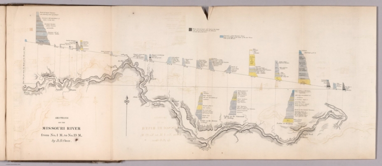
Author
Owen, David Dale
Full Title
Sections on the Missouri River, from No.1 M, to No. 19 M, by D.D. Owen. (to accompany) Illustrations to the Geological Report of Wisconsin, Iowa, and Minnesota. (with) Report of a Geological Survey of Wisconsin, Iowa and Minnesota ... 1852.
List No
0690.041
Note
Map and cross sections, folded to 31x21 cm. Shows settlements and forts. Relief shown by hachures. Include note and explanations.
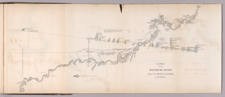
Author
Owen, David Dale
Full Title
Sections on the Missouri River, from No. 20 M, to No. 40 M, by D.D. Owen. (to accompany) Illustrations to the Geological Report of Wisconsin, Iowa, and Minnesota. (with) Report of a Geological Survey of Wisconsin, Iowa and Minnesota ... 1852.
List No
0690.042
Note
Map and colored cross sections, folded to 31x21 cm. Relief shown by hachures and spot heights. Include explanations.
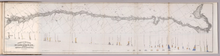
Author
Owen, David Dale
Full Title
Series of sections on the Des Moines River in Iowa, between the Mississippi and the Racoon Fork, by D.D. Owen. Acherman Lith. 379 Broadway, N.Y. (to accompany) Illustrations to the Geological Report of Wisconsin, Iowa, and Minnesota. (with) Report of a Geological Survey of Wisconsin, Iowa and Minnesota ... 1852.
List No
0690.043
Note
Map and colored cross sections, folded to 31x21 cm. Shows settlements and forts. Geologic cross-sections shown in color. Relief shown by hachures. Include explanations.
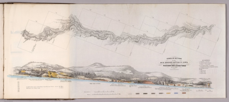
Author
Owen, David Dale
Full Title
Series of sections on the Des Moines River in Iowa, between the Racoon and Lizard Forks, by D.D. Owen. Acherman Lith. 379 Broadway, N.Y. (to accompany) Illustrations to the Geological Report of Wisconsin, Iowa, and Minnesota. (with) Report of a Geological Survey of Wisconsin, Iowa and Minnesota ... 1852.
List No
0690.044
Note
Map and color cross sections, folded to 31x21 cm. Shows settlements and forts. Geologic cross-sections shown in color. Relief shown by hachures. Include reference and explanations.
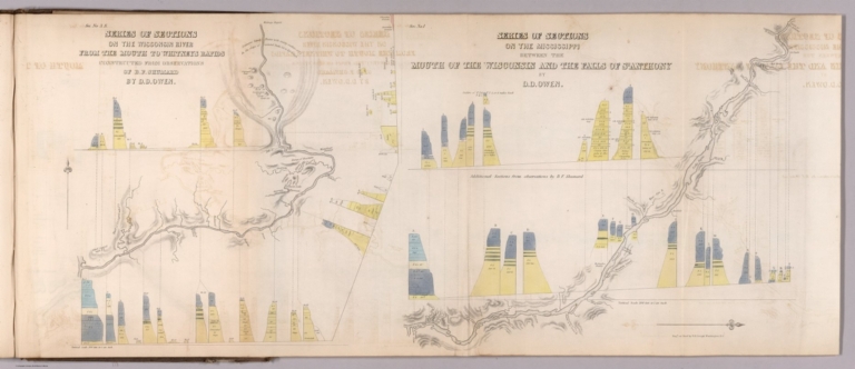
Author
Owen, David Dale
Full Title
Sec. 2. Section along the course of the Mississippi from the mouth of Wisconsin River to Prairie a la Crosse River. (and) Thence by Mountain Island, Cape de Killio, Miniskah, Wazi-Oju and Chippewa Rivers; to Lake Pepin. (with) thence by mouths of Cannon River, Lake St. Croix and St. Peter's River, to the Falls of St. Anthony. Ackerman Lith. 379 Broadway N.Y.(to accompany) Illustrations to the Geological Report of Wisconsin, Iowa, and Minnesota. (with) Report of a Geological Survey of Wisconsin, Iowa and Minnesota ... 1852.
List No
0690.045
Note
3 color cross sections, folded to 31x21 cm.
Author
Owen, David Dale
Full Title
Sec. 3. Section on the St. Croix of the succession, thickness, relative elevation of F.1 & F.2. with their subordinatemembers. By D. Owen. Ackerman Lith. 379 Broadway N.Y. (to accompany) Illustrations to the Geological Report of Wisconsin, Iowa, and Minnesota. (with) Report of a Geological Survey of Wisconsin, Iowa and Minnesota ... 1852.
List No
0690.046
Note
A-F color cross sections, folded to 31x21 cm.
Author
Owen, David Dale
Full Title
Sec. No. 4. Section showing the relative thickness and dip of the lower Magnesian Limestone (F. No.2) and underlying sandstone. With its subordinate beds (F. No.1. b.c.d.e, and f) from the Mississippi River, to the trap exposure at the Falls of St. Croix. By D. Owen. Ackerman Lith. 379 Broadway N.Y. (to accompany) Illustrations to the Geological Report of Wisconsin, Iowa, and Minnesota. (with) Report of a Geological Survey of Wisconsin, Iowa and Minnesota ... 1852.
List No
0690.047
Note
3 color cross sections, folded to 31x21 cm. With views of hills and lake. Relief shown pictorially.
Author
Owen, David Dale
Full Title
Sec. No.5. Geological section on Mississippi River from the mouth of Lake St. Croix to 1 mile above the fall of St. Anthony ... Constructed from observation made by D.D. Owen & B.F. Shumard. Ackerman Lith. 379 Broadway N.Y. (to accompany) Illustrations to the Geological Report of Wisconsin, Iowa, and Minnesota. (with) Report of a Geological Survey of Wisconsin, Iowa and Minnesota ... 1852.
List No
0690.048
Note
4 color cross sections, folded to 31x21 cm. Showing geologic formations. Relief shown pictorially.
Author
Owen, David Dale
Full Title
Sections accompanying the report of Chas. Whittlesey on the Bad River District of south shore Lake Superior. Elevation principally by Dr. Norwood. Ackerman Lith. 379 Broadway N.Y. (to accompany) Illustrations to the Geological Report of Wisconsin, Iowa, and Minnesota. (with) Report of a Geological Survey of Wisconsin, Iowa and Minnesota ... 1852.
List No
0690.049
Note
4 color cross sections, folded to 31x21 cm. Includes: Section No.1.W. Section from the mouth of Apukwaekan of Flag River, south east by south 55 miles to the head of Tyler's Fork. (with)m Section No.2.W. Section of the rocks from the Maringouin Fork of Bad River ... (with) Section No.3.W. Section from the Falls of the East Fork to Bad River ... (with) Section No.4. W. Section from the mouth of Montreal River ... Includes notes.
Author
Owen, David Dale
Full Title
Sec. 2.N. Section by A. Randall along the line of the 4th. P.M. from Lake Superior to the Mississippi ... (with) Section by A. Randall along the 3rd. correction from the Mississippi R. to 4th. P.M. Sec.3 R. Section of hills at the Chippewe red pipestone locality between the Chippewe and Red Cedar Rivers ... By A. randall. Sec. 1 R. Section on Black river from granite at the Falls to sandstone F.1.a. By A. Randall. (with) Geological section at Falls of St. Anthony. By B.F. Shumard. Ackerman Lith. 379 Broadway N.Y. (to accompany) Illustrations to the Geological Report of Wisconsin, Iowa, and Minnesota. (with) Report of a Geological Survey of Wisconsin, Iowa and Minnesota ... 1852.
List No
0690.050
Note
5 color cross sections, folded to 31x21 cm.
Author
Owen, David Dale
Full Title
No. 6. Section on the Iowa side of the Mississippi 30 miles below Lake Pepin at a Great Slide. Ackerman Lith. 379 Broadway N.Y. (to accompany) Illustrations to the Geological Report of Wisconsin, Iowa, and Minnesota. (with) Report of a Geological Survey of Wisconsin, Iowa and Minnesota ... 1852.
List No
0690.051
Note
Color cross section.
Author
Russell, Israel C. (Israel Cook), 1852-1906.
Full Title
Section of the crater walls inclosing the Soda Lakes, Nevada. W.J. McGee. Del. I.C. Russell, Geologist. (to accompany) Geological history of Lake Lahontan : a quaternary lake of Northwestern Nevada. (series title) Department of Interior : Monographs of the United States Geological Survey, vol. XI. (on upper margin) U.S. Geological Survey; Lake Lahontan PL. XVII.
List No
0866.019
Note
5 uncolored geologic cross-section of Soda Lakes.
Author
Russell, Israel C. (Israel Cook), 1852-1906.
Full Title
Section of Lahontan sediments in Humboldt Canon, Nevada. W.J. McGee, Del. I.C. Russell, Geologist. (to accompany) Geological history of Lake Lahontan : a quaternary lake of Northwestern Nevada. (series title) Department of Interior : Monographs of the United States Geological Survey, vol. XI. (on upper margin) U.S. Geological Survey; Lake Lahontan PL. XXIII.
List No
0866.025
Note
9 uncolored geologic cross-sections.
Author
Russell, Israel C. (Israel Cook), 1852-1906.
Full Title
Section of Lahontan sediments in Humboldt Canon, Nevada. W.J. McGee, Del. I.C. Russell, Geologist. (to accompany) Geological history of Lake Lahontan : a quaternary lake of Northwestern Nevada. (series title) Department of Interior : Monographs of the United States Geological Survey, vol. XI. (on upper margin) U.S. Geological Survey; Lake Lahontan PL. XXIV.
List No
0866.026
Note
9 uncolored geologic cross-sections.
Author
Russell, Israel C. (Israel Cook), 1852-1906.
Full Title
Section of Lahontan sediments near Agency Bridge, Truckee Canon, Nevada. W.J. McGee, Del. I.C. Russell, Geologist. (to accompany) Geological history of Lake Lahontan : a quaternary lake of Northwestern Nevada. (series title) Department of Interior : Monographs of the United States Geological Survey, vol. XI. (on upper margin) U.S. Geological Survey; Lake Lahontan PL. XXV.
List No
0866.027
Note
Uncolored geologic cross-section.
Author
Russell, Israel C. (Israel Cook), 1852-1906.
Full Title
Section of Lahontan sediments, Agency Bridge, Truckee River, Nevada. (to accompany) Geological history of Lake Lahontan : a quaternary lake of Northwestern Nevada. (series title) Department of Interior : Monographs of the United States Geological Survey, vol. XI. (on upper margin) U.S. Geological Survey; Lake Lahontan PL.XXVI.
List No
0866.028
Note
Uncolored geologic cross-section.
Author
Russell, Israel C. (Israel Cook), 1852-1906.
Full Title
Detailed section of Lahontan sediments, Truckee Canon, Nevada. W.J. McGee, Del. I.C. Russell, Geologist. (to accompany) Geological history of Lake Lahontan : a quaternary lake of Northwestern Nevada. (series title) Department of Interior : Monographs of the United States Geological Survey, vol. XI. (on upper margin) U.S. Geological Survey; Lake Lahontan PL.XXVII.
List No
0866.029
Note
4 uncolored geologic cross-section.
Author
Russell, Israel C. (Israel Cook), 1852-1906.
Full Title
Detailed section of Lahontan sediments in Walker Canon, Nevada. W.J. McGee, Del. I.C. Russell, Geologist. (to accompany) Geological history of Lake Lahontan : a quaternary lake of Northwestern Nevada. (series title) Department of Interior : Monographs of the United States Geological Survey, vol. XI. (on upper margin) U.S. Geological Survey; Lake Lahontan PL.XXVIII.
List No
0866.030
Note
3 uncolored geologic cross-section.
Author
Spurr, Josiah Edward
Full Title
Sheet VII Sections. U. S. Geological Survey, Charles D. Walcott, Director. Monograph XXXI. Julius Bien & Co. Lith. N.Y. (1898)
List No
0942.004
Note
Geology shown in 16 colored classes, and faults.
Author
Spurr, Josiah Edward
Full Title
Aspen Special Sheet. Sheet X Sections. U. S. Geological Survey, Charles D. Walcott, Director. Monograph XXXI. Julius Bien & Co. Lith. N.Y. (1898)
List No
0942.007
Note
Geologic cross-sections shown in color in 11 classes, and faults.
Author
Spurr, Josiah Edward
Full Title
Tourtelotte Park Special Sheet. Sheet XIII Sections. U. S. Geological Survey, Charles D. Walcott, Director. Monograph XXXI. Julius Bien & Co. Lith. N.Y. (1898)
List No
0942.010
Note
Geologic cross-sections shown in color in 9 classes, and faults.
Author
Spurr, Josiah Edward
Full Title
Tourtelotte Park Special Sheet. Sheet XIV Sections. U. S. Geological Survey, Charles D. Walcott, Director. Monograph XXXI. Julius Bien & Co. Lith. N.Y. (1898)
List No
0942.011
Note
Geologic cross-sections shown in color in 9 classes, and faults.
Author
Spurr, Josiah Edward
Full Title
Tourtelotte Park Special Sheet. Sheet XV Sections. U. S. Geological Survey, Charles D. Walcott, Director. Monograph XXXI. Julius Bien & Co. Lith. N.Y. (1898)
List No
0942.012
Note
Geologic cross-sections shown in color in 9 classes, and faults.
Author
Spurr, Josiah Edward
Full Title
Hunter Park Special Sheet. Sheet XVIII Sections. U. S. Geological Survey, Charles D. Walcott, Director. Monograph XXXI. Julius Bien & Co. Lith. N.Y. (1898)
List No
0942.015
Note
Geologic cross-sections shown in color in 8 classes, and faults.
Author
Spurr, Josiah Edward
Full Title
Lenado Special Sheet. Geology Sheet XX . U. S. Geological Survey, Charles D. Walcott, Director. Monograph XXXI. A.H. Thompson, Geographer. F.M Douglas, Topographer in charge. Triangulation by E.M. Douglas. Topography by W.B. Gorse and R.H. Chapman. Surveyed in 1893. S.F. Emmons, Geologist in Charge. Geology by J.E. Spurr. Assistant, G.W. Tower. Julius Bien & Co. Lith. N.Y. (1898)
List No
0942.017
Note
Geology shown in color in 8 classes of rock, and faults. Map and cross sections on one sheet.
Author
Spurr, Josiah Edward
Full Title
Tourtelotte Park Mining District Sheet. Sheet XXII Sections. U. S. Geological Survey, Charles D. Walcott, Director. Monograph XXXI. Julius Bien & Co. Lith. N.Y. (1898)
List No
0942.019
Note
Geologic cross-sections shown in color in 9 classes, and faults.
Author
Spurr, Josiah Edward
Full Title
Tourtelotte Park Mining District Sheet. Sheet XXIII Sections. U. S. Geological Survey, Charles D. Walcott, Director. Monograph XXXI. Julius Bien & Co. Lith. N.Y. (1898)
List No
0942.020
Note
Geologic cross-sections shown in color in 9 classes, and faults.
Author
Spurr, Josiah Edward
Full Title
Tourtelotte Park Mining District Sheet. Sheet XXIV Sections. U. S. Geological Survey, Charles D. Walcott, Director. Monograph XXXI. Julius Bien & Co. Lith. N.Y. (1898)
List No
0942.021
Note
Geologic cross-sections shown in color in 9 classes, and faults.
Author
Spurr, Josiah Edward
Full Title
Aspen Mountain Sheet. Sheet XXVI Sections. U. S. Geological Survey, Charles D. Walcott, Director. Monograph XXXI. Julius Bien & Co. Lith. N.Y. (1898)
List No
0942.023
Note
Geologic cross-sections shown in color in 10 classes, and faults.
Author
Spurr, Josiah Edward
Full Title
Smuggler Mountain Sheet. Sheet XXVIII Sections. U. S. Geological Survey, Charles D. Walcott, Director. Monograph XXXI. Julius Bien & Co. Lith. N.Y. (1898)
List No
0942.025
Note
Geologic cross-sections shown in color in 9 classes, and faults.
|
![[Without Title. Geological Structure of the Earth, Fossils and Evolution of Amimals]](https://media.davidrumsey.com/MediaManager/srvr?mediafile=/Size3/RUMSEY~8~1/199/10739029.jpg)