|
Author
California Division of Mines and Geology
Full Title
Geologic Map of California, Los Angeles Sheet.
List No
6347.037
Note
Full color. Olaf P. Jenkins Edition.
Author
California Division of Mines and Geology
Full Title
(Composite Map) Geologic Map of California.
List No
6347.114
Note
Full color. Olaf P. Jenkins Edition. Individual sheets dated 1958-1969.
Author
Raymo, Chet
Full Title
(California, Nevada). (to accompany) A geologic and topographic profile of the United States along interstate 80 : by Chet Raymo. 1982. Printed by Hubbard, Northbrook, IL.
List No
13323.006
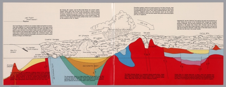
Note
Geologic cross section and map. Covers the area from Pacific Ocean and San Francisco to Carson Sink, showing the volcanic peaks, fault zone, weather system, lakes, drainage, cities and mountains. Includes descriptive text.
Author
Raymo, Chet
Full Title
(Composite). A geologic and topographic profile of the United States along interstate 80 : by Chet Raymo. 1982. Printed by Hubbard, Northbrook, IL.
List No
13323.014
Note
Composite of 8 sheets of geologic cross section and topographic map. Covers the route along Interstate 80 from San Francisco to New York City.
Author
[U.S. Geological Survey, Alpha, Tau Rho]
Full Title
Southern California Borderland.
List No
6353.087
Author
King, Clarence
Full Title
(Covers to) Engineer Department U.S.A. Geological and Topographical Atlas Accompanying the Report of the Geological Exploration of the Fortieth Parallel Made by the Authority of the Honorable Secretary of War under the direction of Brig. and Brvt. Major General A.A. Humphreys, Chief of Engineers U.S.A. by Clarence King, U.S. Geologist in Charge, 1876. Julius Bien Lith.
List No
0408A
Author
King, Clarence
Full Title
(Title Page to) Engineer Department U.S.A. Geological and Topographical Atlas Accompanying the Report of the Geological Exploration of the Fortieth Parallel Made by the Authority of the Honorable Secretary of War under the direction of Brig. and Brvt. Major General A.A. Humphreys, Chief of Engineers U.S.A. by Clarence King, U.S. Geologist in Charge, 1876. Julius Bien Lith.
List No
0408B
Note
Magnificent, huge atlas showing the area of the 40th Parallel Survey in topographical and geological maps. Wheat notes: "These are pioneer survey maps, and as such are most interesting. Mapping the West in so broad a cross-section had never before been attempted, a portent of things to come." King, at the age of 25, was made Geologist-in-charge of the Survey in 1867. He was formally ordered "to examine and describe the geological structure, geographical condition and natural resources of a belt of country extending from the 120th meridian eastward to the 105th meridian, along the 40th parallel of latitude with sufficient expansion north and south to include the lines of 'Central' and 'Union Pacific' railroads..." (Wheat). The topographical sheets depict features by brush shading rather than hachuring. In original binding -rare. Bound in green half leather with a label on the front, "Geological and Topographical Atlas Accompanying the Report of the Geological Exploration of the Fortieth Parallel. Clarence King, Geologist in Charge."
Author
King, Clarence
Full Title
(Index Page to) Engineer Department U.S.A. Geological and Topographical Atlas Accompanying the Report of the Geological Exploration of the Fortieth Parallel Made by the Authority of the Honorable Secretary of War under the direction of Brig. and Brvt. Major General A.A. Humphreys, Chief of Engineers U.S.A. by Clarence King, U.S. Geologist in Charge, 1876. Julius Bien Lith.
List No
0408C
Note
Index page includes the list of maps and a legend naming the mapmakers and the basis by which the maps were made.
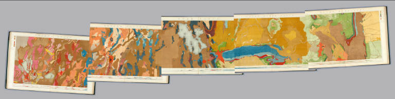
Author
King, Clarence
Full Title
Nevada Basin. Map V. (Geological)
List No
0408.006
Note
Map in full color with the legends on either side of the maps. Map extends from Argenta, Nevada to the west of Pyramid Lake (Lake Tahoe) in California. Below the map are two geologic cross sections.
Author
King, Clarence
Full Title
(Composite of) Geological Maps I-V, 40th Parallel Survey.
List No
0408.007
Note
Maps in full color with the legends on either side of the maps.
Author
King, Clarence
Full Title
General Sections.
List No
0408.008
Note
In full color. Ten sections shown with the legends on either side of the cross sections.
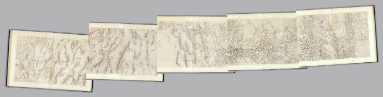
Author
King, Clarence
Full Title
Nevada Basin. Map V. (Topographical)
List No
0408.013
Note
Map in brown shaded relief. Map extends from Argenta, Nevada to the west of Pyramid Lake (Lake Tahoe) in California.
Author
King, Clarence
Full Title
(Composite of) Topographical Maps I-V, 40th Parallel Survey.
List No
0408.014
Note
Maps in brown shaded relief.
Author
Berghaus, Hermann
Full Title
Tieflander. Entw. v. Herm. Berghaus 1883, Ausg. 1887. Gez. v. C. Schmidt u. M. Risch. Gotha: Justus Perthes (1892)
List No
1578.002
Note
Lithographed maps, color. Relief shown by altitude tints. Contents: Die Heutigen Niederlande -- Fen District -- El-Ghor oder das Jordan Thal -- Kaspisches Tiefland und Manytsch Niederrung -- Natron-Seen -- El Fajum -- Nordrand der Libyschen Wuste -- Das Todte Thal -- Colorado-Wuste -- Nordrand der Algerischen Sahara -- Goban n. Paulistischke -- Sud-Australische Seen -- Tiefland Asale -- Assal-See. Inset maps at 1:6,000,000: Niederlande in 1. Jahrhundert -- Niederlande in X. Jahrhundert.
Author
Berghaus, Hermann
Full Title
Nord-Amerika. Ubersicht von Nord-Amerika. (with) Virginia-Silber-Minen. (with) Das Yosemite-Thal. (with) Landenge von Tehuantepec n. J.C. Spear 1871. (with) Landenge von Nicaragua. (with) Die Krater des Turrialba. (with) Landenge von Panama. (with) Seeboden der New-York-Bay. (with) Popocatepetl. (with) Citlaltepetl. (with) Canons des Colorado. (with) Yellowstone-National-Park. (with) Reykjanes und Geyser nach Th. Thoroddsen. Entw. v. Herm. Berghaus 1886, Ausg. 1887. Nebenkarten gez. v. M. Risch. Gotha: Justus Perthes (1892)
List No
1578.012
Note
Lithographed geologic map, color with 12 inset maps. Relief shown by spot heights. Some inset maps are topographic maps showing relief by hachures and spot heights.
Author
Becker, George F.
Full Title
Geological Map of the Sulphur Bank District. U.S. Geological Survey. Monograph XIII, Atlas Sheet IV. S.H. Bodfish 1882, J.D. Hoffman 1884, Topographers. Giles Litho. & Liberty Printing Co. Geo. F. Becker, Geologist in charge.
List No
4580.002
Note
Shows in color three classes of rock. Relief shown by 20-foot contour lines. Shows mines, streams, and settlements.
Author
Becker, George F.
Full Title
Geological Map of the Knoxville District. U.S. Geological Survey. Monograph XIII, Atlas Sheet V. Topography by J.D. Hoffman 1883. Geo. F. Becker, Geologist in charge. Topographical Map of the Region of Clear Lake. Compiled by C.F. Hoffmann. Geo. F. Becker, Geologist in charge.
List No
4580.003
Note
Two maps on one sheet. Knoxville District map relief shown with 25-foot contours. Shows in color five classes of rock. Longitude and latitude shown. Scale 1:15,000. Clear Lake Region map shows topography with shaded relief, streams, mines, settlements, and roads. Scale 1:95,000. Outlines of Sulphur Bank District and Knoxville District shown.
Author
Becker, George F.
Full Title
Geological Map of the New Idria District. U.S. Geological Survey. Monograph XIII, Atlas Sheet VI. J.D. Hoffman, Topographer. Giles Litho. & Liberty Printing Co. N.Y. Geo. F. Becker, Geologist in charge.
List No
4580.004
Note
Shows in color three classes of rock. Relief shown by 40-foot contour lines. Shows streams, settlements, mines, trails, and roads.
Author
Becker, George F.
Full Title
Geological Map of the New Almaden Mining District. U.S. Geological Survey. Monograph XIII, Atlas Sheet VII. Topography by S.W. Bodfish and others. Giles Litho. & Liberty Printing Co. N.Y. Geo. F. Becker, Geologist in charge.
List No
4580.005
Note
Shows in color six classes of rock. Relief shown by 20-foot contour lines. Shows streams, settlements, mines, and roads.
Author
Becker, George F.
Full Title
Ore-Bodies and Topography of Mine-Hill, New Almaden. U.S. Geological Survey. Monograph XIII, Atlas Sheet VIII. Compiled by F. Reade 1885. Giles Litho. & Liberty Printing Co. N.Y. Geo. F. Becker, Geologist in charge.
List No
4580.006
Note
Shows in topography with 10-foot contours, ore bodies with cross-hatching, mine dumps with hachures, +streams, roads, tramways, tunnels and shafts.
Author
Becker, George F.
Full Title
Plan of the New Almaden Mine. U.S. Geological Survey. Monograph XIII, Atlas Sheet IX. Compiled by F. Reade 1885. Giles Litho. & Liberty Printing Co. N.Y. Geo. F. Becker, Geologist in charge.
List No
4580.007
Note
Shows depths, tunnels, drifts, galleries, and shafts in brilliant color.
Author
Becker, George F.
Full Title
Longitudinal Section of the South Ore Channel. New Almaden Mine. U.S. Geological Survey. Monograph XIII, Atlas Sheet X. Compiled by F. Reade 1885. Giles Litho. & Liberty Printing Co. N.Y. Geo. F. Becker, Geologist in charge.
List No
4580.008
Note
Shows depths, tunnels, drifts, galleries, and shafts.
Author
Becker, George F.
Full Title
North and South Section , 550 Feet West of Randol Shaft, New Almaden Mine. North and South Section through the Randol Shaft, New Almaden Mine. U.S. Geological Survey. Monograph XIII, Atlas Sheet XI. Compiled by F. Reade 1885. Geo. F. Becker, Geologist in charge.
List No
4580.009
Note
Two vertical sections on one sheet. Shows depths, tunnels, drifts, galleries, and shafts.
Author
Becker, George F.
Full Title
East and West Vertical Section, New Almaden Mine. U.S. Geological Survey. Monograph XIII, Atlas Sheet XII. Compiled by F. Reade 1885. Geo. F. Becker, Geologist in charge.
List No
4580.010
Note
Shows depths, tunnels, drifts, galleries, and shafts.
Author
Becker, George F.
Full Title
Plan of the Clay Walls, New Almaden Mine. U.S. Geological Survey. Monograph XIII, Atlas Sheet XIII. Compiled by F. Reade 1885. Giles Litho. & Liberty Printing Co. N.Y. Geo. F. Becker, Geologist in charge.
List No
4580.011
Note
Shows alignments of clay walls.
Author
[USGS (U.S. Geological Survey), Walcott, Charles D., Thompson, A.H., Sudworth, George B., Gannett, Henry]
Full Title
Plate LXXXV. Placerville Quadrangle, Land Classification and Density of Standing Timber.
List No
6322.117
Note
Color. Relief shown in contours.
Author
[USGS (U.S. Geological Survey), Walcott, Charles D., Gannett, Henry, Sudworth, George B.]
Full Title
Plate LXXXVI. Pyramid Peak Quadrangle, Land Classification and Density of Standing Timber. Julius Bien & Co. Lith. N.Y.
List No
6322.118
Note
Color. Relief shown in contours.
Author
[USGS (U.S. Geological Survey), Walcott, Charles D., Sudworth, George B.]
Full Title
Plate LXXXVII. Jackson Quadrangle, Land Classification and Density of Standing Timber. Julius Bien & Co. Lith. N.Y.
List No
6322.119
Note
Color. Relief shown in contours.
Author
[USGS (U.S. Geological Survey), Walcott, Charles D., Sudworth, George B.]
Full Title
Plate LXXXVIII. Big Trees Quadrangle, California. Land Classification and Density of Standing Timber.
List No
6322.120
Note
Color. Relief shown in contours.
Author
[USGS (U.S. Geological Survey), Walcott, Charles D., Sudworth, George B.]
Full Title
Plate LXXXIX. Markleeville Quadrangle, California. Land Classification and Density of Standing Timber. Julius Bien & Co. Lith. N.Y.
List No
6322.121
Note
Color. Relief shown in contours.
Author
[USGS (U.S. Geological Survey), Sudworth, George B., Walcott, Charles D.]
Full Title
Plate XC. Dardanelles Quadrangle, California. Land Classification and Density of Standing Timber. Julius Bien & Co. Lith. N.Y.
List No
6322.122
Note
Topography surveyed 1891 and 1896 (see index map in margin). Color. Relief shown in contours.
Author
[USGS (U.S. Geological Survey), Walcott, Charles D., Sudworth, George B.]
Full Title
(View) Plate XCI. A. California White Oak (Quercus Douglasii Hook and Arn.), Southern Calaveras County. B. Typical Wagon Road in Yellow-Pine Forest, Southwestern Section of Stanislaus Forest Reserve.
List No
6322.123
Note
Photographs.
Author
[USGS (U.S. Geological Survey), Walcott, Charles D., Sudworth, George B.]
Full Title
(View) Plate XCII. A. Long Barn, A Typical Road Station in Yellow-Pine Belt, North Fork of Tuolumne River. B. Interior of Yellow-Pine Forest on North Fork of Tuolumne River.
List No
6322.124
Note
Photographs.
Author
[USGS (U.S. Geological Survey), Walcott, Charles D., Sudworth, George B.]
Full Title
(View) Plate XCIII. A. Jeffrey Pine (Pinus Jeffreyi "Oreg. Com.") 4 Feet in Diameter. This shows best form of timber trees in yellow-pine belt, headwaters of South Fork of Stanislaus River, Stanislaus Forest Reserve. B. White Fir (Abies concolor Parry) 4 1/2 Feet in Diameter. Headwater of South Fork of Stanislaus River, Stanislaus Forest Reserve.
List No
6322.125
Note
Photographs.
Author
[USGS (U.S. Geological Survey), Walcott, Charles D., Sudworth, George B.]
Full Title
(View) Plate XCIV. A. Yellow Pine (Abies ponderosa Laws. 3 Feet in Diameter). Near Middle Fork of Stanislaus Forest Reserve. B. Characteristic Distribution of Yellow Pine in Forests. East Slope of Middle Fork of Stanislaus River, between Cow Creek and Lily Creek, Stanislaus Forest Reserve.
List No
6322.126
Note
Photographs.
Author
[USGS (U.S. Geological Survey), Walcott, Charles D., Sudworth, George B.]
Full Title
(View) Plate XCV. A. Cattle Herder's Summer Cabin, Bear Meadows, Stanislaus Forest Reserve. B. California Red Fir (Abies magnifica Murr.) 39 Inches in Diameter. West Fork Middle Fork of Stanislaus River, near headwaters Lily Creek, Stanislaus Forest Reserve.
List No
6322.127
Note
Photographs.
Author
[USGS (U.S. Geological Survey), Walcott, Charles D., Sudworth, George B.]
Full Title
(View) Plate XCVI. A. Sugar Pine (Pinus Lambertiana Dougl.) 50 Inches in Diameter. B. West slope of Middle Fork of Stanislaus River, near headwaters of Cow Creek, Stanislaus Forest Reserve. B. Characteristic Scattered and Stunted Growth of California Red Fir, Jeffrey Pine and Juniper. High rocky summits on headwaters of Lily Creek, Stanislaus Forest Reserve.
List No
6322.128
Note
Photographs.
Author
[USGS (U.S. Geological Survey), Walcott, Charles D., Sudworth, George B.]
Full Title
(View) Plate XCVII. A. Canyon of Middle Fork of Stanislaus River at Donald's Flat. Looking south from near the mouth Dardanelles Creek, Stanislaus Forest Reserve, B. Western Juniper (Juniperus occidentalis Hook.) 28 and 30 inches in Diameter. Northwest border of Stanislaus Forest Reserve.
List No
6322.129
Note
Photographs.
Author
[USGS (U.S. Geological Survey), Walcott, Charles D., Sudworth, George B.]
Full Title
(View) Plate XCVIII. A. Falls of Middle Fork of Stanislaus River at North End of Donald's Flat, Stanislaus Forest Reserve. B. Type of Jeffrey-Pine Forest, Headwaters of Summit Creek.
List No
6322.130
Note
Photographs.
Author
[USGS (U.S. Geological Survey), Walcott, Charles D., Sudworth, George B.]
Full Title
(View) Plate XCIX. A. Incense Cedar (Libocedrus decurrens Torr.) 50 inches in Diameter, Showing the Effects of Annual Burning, near Dry Meadows, on Headwaters of Soap Creek. B. Trunk of Big Tree (Sequoia gigantea), Tuolumne Big-Tree Grove.
List No
6322.131
Note
Photographs.
Author
[USGS (U.S. Geological Survey), Walcott, Charles D., Sudworth, George B.]
Full Title
(View) Plate C. A. Young Growth of Yellow Pine, White Fir, and Incense Cedar Killed by Surface Fires, Near Mouth of Soap Creek. B. Abundant Reproduction of Yellow Pine on Middle Fork of Stanislaus River.
List No
6322.132
Note
Photographs.
Author
[USGS (U.S. Geological Survey), Walcott, Charles D., Sudworth, George B.]
Full Title
(View) Plate CI. A. Sawmill near Headwaters of Love Creek. B. Effects of Annual Surface Fires and Excessive Grazing in Preventing all Reproduction, Headwaters of Jesus Maria Creek.
List No
6322.133
Note
Photographs.
Author
[USGS (U.S. Geological Survey), Walcott, Charles D., Sudworth, George B.]
Full Title
(View) Plate CII. A. B. Calaveras Big-Tree Grove.
List No
6322.134
Note
Photographs.
Author
[USGS (U.S. Geological Survey), Walcott, Charles D., Sudworth, George B.]
Full Title
(View) Plate CIII. A. California Black Oak (Quercus Californica (Torr.) Cooper). B. Best Development and Maximum Density of a Mixed Forest.
List No
6322.135
Note
Photographs.
Author
[USGS (U.S. Geological Survey), Walcott, Charles D., Sudworth, George B.]
Full Title
(View) Plate CIV. A. Band of Sheep in Yellow Pine Forest, near South Fork of Mokelumne River. B. Shake-Maker's Cabin.
List No
6322.136
Note
Photographs.
Author
[USGS (U.S. Geological Survey), Walcott, Charles D., Sudworth, George B.]
Full Title
(View) Plate CV. A. Reproduction of California Red Fir (Abies magnifica Murr.), Gravelly Mountain Summits, near Headwaters of Blue Creek. B. Subalpine Lake and Marshy Meadow.
List No
6322.137
Note
Photographs.
Author
[USGS (U.S. Geological Survey), Walcott, Charles D., Sudworth, George B.]
Full Title
(View) Plate CVI. A. Forest Fire Set by Lumbermen to Burn Out a "Jam" of Tops. B. Interior of Yellow-Pine Forest on Sandy Bench Land.
List No
6322.138
Note
Photographs.
Author
[USGS (U.S. Geological Survey), Walcott, Charles D., Sudworth, George B.]
Full Title
(View) Plate CVII. A. South Fork of American River near Bullion Bend. B. Canyon of South Fork of American River.
List No
6322.139
Note
Photographs.
Author
[USGS (U.S. Geological Survey), Walcott, Charles D., Sudworth, George B.]
Full Title
(View) Plate CVIII. A. Cascade Lake, Looking Southwest from North End of Lake. B. West Slope of Rubicon River Canyon.
List No
6322.140
Note
Photographs.
Author
[USGS (U.S. Geological Survey), Walcott, Charles D., Sudworth, George B.]
Full Title
(View) Plate CIX. A. Little South Gerle Creek at West End of Loon Lake B. Sugar Pine 4 Feet in Diameter Felled by Persistent Burning.
List No
6322.141
Note
Photographs.
|