|
REFINE
Browse All : Geologic Atlas and Atlas Map of United States
1-38 of 38
Author
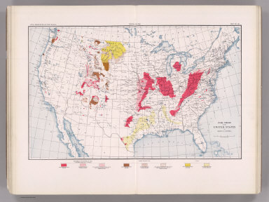
Campbell, Marius R.
Full Title
Coal Resources of the World. United States. Map No. 28. Coal Fields of the United States by Marius R. Campbell.
List No
2249.030
Note
Coal fields shown in color.
Author
Hague, Arnold
Full Title
Gallatin Sheet. Topography Sheet IV. Monograph XXXII. Yellowstone National Park. U.S. Geological Survey. Charles D. Walcott, Director. 1904. Julius Bien & Co. Lith. N.Y. Henry Gannett, Chief Geographer. J.H. Renshawe, Geographer in charge. Triangulation by H.S. Chase. Topography by J.H. Renshawe, Frank Tweedy, H.S. Chase, and S.A. Alpin Jr. Surveyed in 1883-5.
List No
4252.001
Note
Topography shown in 100-foot contours.
Author
Hague, Arnold
Full Title
Shoshone Sheet. Topography Sheet V. Monograph XXXII. Yellowstone National Park. U.S. Geological Survey. Charles D. Walcott, Director. 1904. Julius Bien & Co. Lith. N.Y. Henry Gannett, Chief Geographer. J.H. Renshawe, Geographer in charge. Triangulation by H.S. Chase. Topography by W.H. Leffingwell, Frank Tweedy, J.H. Renshawe, and S.A. Alpin Jr. Surveyed in 1884-5.
List No
4252.002
Note
Topography shown in 100-foot contours.
Author
Hague, Arnold
Full Title
Canyon Sheet. Topography Sheet VI. Monograph XXXII. Yellowstone National Park. U.S. Geological Survey. Charles D. Walcott, Director. 1904. Julius Bien & Co. Lith. N.Y. Henry Gannett, Chief Geographer. J.H. Renshawe, Geographer in charge. Triangulation by H.S. Chase. Topography by Frank Tweedy. Surveyed in 1884-5.
List No
4252.003
Note
Topography shown in 100-foot contours.
Author
Hague, Arnold
Full Title
Lake Sheet. Topography Sheet VII. Monograph XXXII. Yellowstone National Park. U.S. Geological Survey. Charles D. Walcott, Director. 1904. Julius Bien & Co. Lith. N.Y. Henry Gannett, Chief Geographer. J.H. Renshawe, Geographer in charge. Triangulation by H.S. Chase. Topography by J.H. Renshawe. Surveyed in 1885.
List No
4252.004
Note
Topography shown in 100-foot contours.
Author
Hague, Arnold
Full Title
Crandall Sheet. Topography Sheet VIII. Monograph XXXII. Yellowstone National Park. U.S. Geological Survey. Charles D. Walcott, Director. 1904. Julius Bien & Co. Lith. N.Y. A. H. Thompson, Geographer. Triangulation and Topography by Frank Tweedy. Surveyed in 1893.
List No
4252.005
Note
Topography shown in 100-foot contours.
Author
Hague, Arnold
Full Title
Ishawooa Sheet. Topography Sheet IX. Monograph XXXII. Yellowstone National Park. U.S. Geological Survey. Charles D. Walcott, Director. 1904. Julius Bien & Co. Lith. N.Y. A. H. Thompson, Geographer. Triangulation and Topography by Frank Tweedy. Surveyed in 1893.
List No
4252.006
Note
Topography shown in 100-foot contours.
Author
Hague, Arnold
Full Title
Gallatin Sheet. Geology Sheet X. Monograph XXXII. Yellowstone National Park. U.S. Geological Survey. Charles D. Walcott, Director. 1904. Julius Bien & Co. Lith. N.Y. Henry Gannett, Chief Geographer. J.H. Renshawe, Geographer in charge. Triangulation by H.S. Chase. Topography by J.H. Renshawe, Frank Tweedy, H.S. Chase, and S.A. Alpin Jr. Surveyed in 1883-5. Geology by Arnold Hague, Geologist in charge, Joseph Paxson Iddings, Walter Harvey Weed, and George M. Wright, Surveyed 1883 to 91, and 93.
List No
4252.007
Note
Topography shown in 100-foot contours, overlaid in color with 26 classes of rock types, and faults. Legend.
Author
Hague, Arnold
Full Title
Shoshone Sheet. Geology Sheet XI. Monograph XXXII. Yellowstone National Park. U.S. Geological Survey. Charles D. Walcott, Director. 1904. Julius Bien & Co. Lith. N.Y. Henry Gannett, Chief Geographer. J.H. Renshawe, Geographer in charge. Triangulation by H.S. Chase. Topography by W.H. Leffingwell, Frank Tweedy, J.H. Renshawe, and S.A. Alpin Jr. Surveyed in 1884-5. Geology by Arnold Hague, Geologist in charge, Joseph Paxson Iddings, and Walter Harvey Weed, Surveyed 1883 to 91, and 1893.
List No
4252.008
Note
Topography shown in 100-foot contours, overlaid in color with 22 classes of rock types, and faults. Legend.
Author
Hague, Arnold
Full Title
Canyon Sheet. Geology Sheet XII. Monograph XXXII. Yellowstone National Park. U.S. Geological Survey. Charles D. Walcott, Director. 1904. Julius Bien & Co. Lith. N.Y. Henry Gannett, Chief Geographer. J.H. Renshawe, Geographer in charge. Triangulation by H.S. Chase. Topography by Frank Tweedy. Surveyed in 1884-5. Geology by Arnold Hague, Geologist in charge, Joseph Paxson Iddings, Walter Harvey Weed, and George M. Wright, Surveyed 1883 to 91, and 93.
List No
4252.009
Note
Topography shown in 100-foot contours, overlaid in color with 22 classes of rock types, and faults. Legend.
Author
Hague, Arnold
Full Title
Lake Sheet. Geology Sheet VII. Monograph XXXII. Yellowstone National Park. U.S. Geological Survey. Charles D. Walcott, Director. 1904. Julius Bien & Co. Lith. N.Y. Henry Gannett, Chief Geographer. J.H. Renshawe, Geographer in charge. Triangulation by H.S. Chase. Topography by J.H. Renshawe. Surveyed in 1885. Geology by Arnold Hague, Geologist in charge, Joseph Paxson Iddings, and Walter Harvey Weed, Surveyed 1883 to 89, and 93.
List No
4252.010
Note
Topography shown in 100-foot contours, overlaid in color with 22 classes of rock types, and faults. Legend.
Author
Hague, Arnold
Full Title
Crandall Sheet. Geology Sheet VIII. Monograph XXXII. Yellowstone National Park. U.S. Geological Survey. Charles D. Walcott, Director. 1904. Julius Bien & Co. Lith. N.Y. A. H. Thompson, Geographer. Triangulation and Topography by Frank Tweedy. Surveyed in 1893. Geology by Arnold Hague, Geologist in charge, Assisted by Joseph P. Iddings and Thomas A. Jaggar Jr., Surveyed in 1893 and 1897.
List No
4252.011
Note
Topography shown in 100-foot contours, overlaid in color with 15 classes of rock types, and dikes and faults. Legend.
Author
Hague, Arnold
Full Title
Ishawooa Sheet. Geology Sheet XV. Monograph XXXII. Yellowstone National Park. U.S. Geological Survey. Charles D. Walcott, Director. 1904. Julius Bien & Co. Lith. N.Y. A. H. Thompson, Geographer. Triangulation and Topography by Frank Tweedy. Surveyed in 1893. Geology by Arnold Hague, Geologist in charge, Assisted by Thomas A. Jaggar Jr., Surveyed in 1893 and 1897.
List No
4252.012
Note
Topography shown in 100-foot contours, overlaid in color with 11 classes of rock types, and dikes and faults. Legend.
Author
Hague, Arnold
Full Title
Yellowstone National Park and Portion of Yellowstone Forest Reserve. Topography Sheet XVI. Monograph XXXII. Yellowstone National Park. U.S. Geological Survey. Charles D. Walcott, Director. 1904. Julius Bien & Co. Lith. N.Y. Reduced from U.S. Geological Survey Atlas sheets.
List No
4252.013
Note
Topography shown in 100-foot contours. Roads and trails shown.
Author
Hague, Arnold
Full Title
Yellowstone National Park and Portion of Yellowstone Forest Reserve. Geology Sheet XVII. Monograph XXXII. Yellowstone National Park. U.S. Geological Survey. Charles D. Walcott, Director. 1904. Julius Bien & Co. Lith. N.Y. Geology by Arnold Hague, Geologist in charge, Assisted by Joseph P. Iddings, Walter Harvey Weed, George M. Wright, and Thomas A. Jaggar Jr.
List No
4252.014
Note
Topography shown in 100-foot contours, overlaid in vibrant color with 34 classes of rock types, and dikes and faults. Legend.
Author
Hague, Arnold
Full Title
Mammoth Hot Springs and Vicinity. Topography Sheet XVIII. Monograph XXXII. Yellowstone National Park. U.S. Geological Survey. Charles D. Walcott, Director. 1904. Julius Bien & Co. Lith. N.Y. Topography by Anton Karl, assisted by Joseph R. Bien.
List No
4252.015
Note
Topography shown in 20-foot contours. Structures, roads and trails shown.
Author
Hague, Arnold
Full Title
Mammoth Hot Springs and Vicinity. Geology Sheet XIX. Monograph XXXII. Yellowstone National Park. U.S. Geological Survey. Charles D. Walcott, Director. 1904. Julius Bien & Co. Lith. N.Y. Topography by Anton Karl, assisted by Joseph R. Bien. Geology by Arnold Hague, Geologist in charge and Walter Harvey Weed.
List No
4252.016
Note
Topography shown in 20-foot contours, overlaid in color with 12 classes of rock types. Legend.
Author
Hague, Arnold
Full Title
Detail Map of Mammoth Hot Springs Travertine Terraces. Topography Sheet XX. Monograph XXXII. Yellowstone National Park. U.S. Geological Survey. Charles D. Walcott, Director. 1904. Julius Bien & Co. Lith. N.Y. Topography by Anton Karl, assisted by Joseph R. Bien. Mapped in 1887. Partially revised 1899 by R.H. Chapman.
List No
4252.017
Note
Topography shown in 5-foot contours. Structures and roads shown.
Author
Hague, Arnold
Full Title
Norris Geyser Basin. Geology Sheet XXI. Monograph XXXII. Yellowstone National Park. U.S. Geological Survey. Charles D. Walcott, Director. 1904. Julius Bien & Co. Lith. N.Y. Topography by Anton Karl, assisted by Joseph R. Bien. Geology by Arnold Hague and Walter Harvey Weed.
List No
4252.018
Note
Topography shown in 10-foot contours, overlaid in color with 6 classes of rock types. Legend.
Author
Hague, Arnold
Full Title
Firehole Geyser Basin. Geology Sheet XXII. Monograph XXXII. Yellowstone National Park. U.S. Geological Survey. Charles D. Walcott, Director. 1904. Julius Bien & Co. Lith. N.Y. Topography by Anton Karl, assisted by Joseph R. Bien. Geology by Arnold Hague, Geologist in charge, and Walter Harvey Weed.
List No
4252.019
Note
Topography shown in 10-foot contours, overlaid in color with 6 classes of rock types. Legend.
Author
Hague, Arnold
Full Title
Excelsior Geyser Basin. Geology Sheet XXIII. Monograph XXXII. Yellowstone National Park. U.S. Geological Survey. Charles D. Walcott, Director. 1904. Julius Bien & Co. Lith. N.Y. Topography by Anton Karl, assisted by Joseph R. Bien. Geology by Arnold Hague and Walter Harvey Weed.
List No
4252.020
Note
Topography shown in 5-foot contours, overlaid in color with 4 classes of rock types. Legend.
Author
Hague, Arnold
Full Title
Upper Geyser Basin. Geology Sheet XXIV. Monograph XXXII. Yellowstone National Park. U.S. Geological Survey. Charles D. Walcott, Director. 1904. Julius Bien & Co. Lith. N.Y. Topography by Anton Karl, assisted by Joseph R. Bien. Geology by Arnold Hague, Geologist in charge, and Walter Harvey Weed.
List No
4252.021
Note
Topography shown in 20-foot contours, overlaid in color with 5 classes of rock types. Legend.
Author
Hague, Arnold
Full Title
Central Portion of Upper Geyser Basin. Topography Sheet XXV. Monograph XXXII. Yellowstone National Park. U.S. Geological Survey. Charles D. Walcott, Director. 1904. Julius Bien & Co. Lith. N.Y. Topography by Anton Karl, assisted by Joseph R. Bien.
List No
4252.022
Note
Topography shown in 5-foot contours. Shows structures and roads.
Author
Hague, Arnold
Full Title
Shoshone Geyser Basin. Geology Sheet XXVI. Monograph XXXII. Yellowstone National Park. U.S. Geological Survey. Charles D. Walcott, Director. 1904. Julius Bien & Co. Lith. N.Y. Topography by Anton Karl, assisted by Joseph R. Bien. Surveyed by Hayden Survey, 1878, revised and contours added by Walter Harvey Weed. Geology by Walter Harvey Weed.
List No
4252.023
Note
Topography shown in 5-foot contours, overlaid in color with 5 classes of rock types. Legend.
Author
Hague, Arnold
Full Title
The Shores of Yellowstone Lake. Geology Sheet XXVII. Monograph XXXII. Yellowstone National Park. U.S. Geological Survey. Charles D. Walcott, Director. 1904. Julius Bien & Co. Lith. N.Y. A.H. Thompson, Geographer. Topography by Frank E. Grove, Philip Sawyer under charge of Frank Tweedy. Suveryed in 1889. Arnold Hague, Geologist in charge. Geology by Walter Harvey Weed.
List No
4252.024
Note
Topography shown in 20-foot contours, overlaid in color with 7 classes of rock types. Legend. Note provided on the survey history and on the geomorphic history of Yellowstone Lake.
Author
Becker, George F.
Full Title
Geological Map of the Clear Lake District. U.S. Geological Survey. Monograph XIII, Atlas Sheet III. Topography compiled by C.F. Hoffmann. Giles Litho. & Liberty Printing Co. Geo. F. Becker, Geologist in charge.
List No
4580.001
Note
Shows in color six classes of rock. Streams and settlements shown including borax works. Outline of Plate IV shown.
Author
Becker, George F.
Full Title
Geological Map of the Sulphur Bank District. U.S. Geological Survey. Monograph XIII, Atlas Sheet IV. S.H. Bodfish 1882, J.D. Hoffman 1884, Topographers. Giles Litho. & Liberty Printing Co. Geo. F. Becker, Geologist in charge.
List No
4580.002
Note
Shows in color three classes of rock. Relief shown by 20-foot contour lines. Shows mines, streams, and settlements.
Author
Becker, George F.
Full Title
Geological Map of the Knoxville District. U.S. Geological Survey. Monograph XIII, Atlas Sheet V. Topography by J.D. Hoffman 1883. Geo. F. Becker, Geologist in charge. Topographical Map of the Region of Clear Lake. Compiled by C.F. Hoffmann. Geo. F. Becker, Geologist in charge.
List No
4580.003
Note
Two maps on one sheet. Knoxville District map relief shown with 25-foot contours. Shows in color five classes of rock. Longitude and latitude shown. Scale 1:15,000. Clear Lake Region map shows topography with shaded relief, streams, mines, settlements, and roads. Scale 1:95,000. Outlines of Sulphur Bank District and Knoxville District shown.
Author
Becker, George F.
Full Title
Geological Map of the New Idria District. U.S. Geological Survey. Monograph XIII, Atlas Sheet VI. J.D. Hoffman, Topographer. Giles Litho. & Liberty Printing Co. N.Y. Geo. F. Becker, Geologist in charge.
List No
4580.004
Note
Shows in color three classes of rock. Relief shown by 40-foot contour lines. Shows streams, settlements, mines, trails, and roads.
Author
Becker, George F.
Full Title
Geological Map of the New Almaden Mining District. U.S. Geological Survey. Monograph XIII, Atlas Sheet VII. Topography by S.W. Bodfish and others. Giles Litho. & Liberty Printing Co. N.Y. Geo. F. Becker, Geologist in charge.
List No
4580.005
Note
Shows in color six classes of rock. Relief shown by 20-foot contour lines. Shows streams, settlements, mines, and roads.
Author
Becker, George F.
Full Title
Ore-Bodies and Topography of Mine-Hill, New Almaden. U.S. Geological Survey. Monograph XIII, Atlas Sheet VIII. Compiled by F. Reade 1885. Giles Litho. & Liberty Printing Co. N.Y. Geo. F. Becker, Geologist in charge.
List No
4580.006
Note
Shows in topography with 10-foot contours, ore bodies with cross-hatching, mine dumps with hachures, +streams, roads, tramways, tunnels and shafts.
Author
Becker, George F.
Full Title
Plan of the New Almaden Mine. U.S. Geological Survey. Monograph XIII, Atlas Sheet IX. Compiled by F. Reade 1885. Giles Litho. & Liberty Printing Co. N.Y. Geo. F. Becker, Geologist in charge.
List No
4580.007
Note
Shows depths, tunnels, drifts, galleries, and shafts in brilliant color.
Author
Becker, George F.
Full Title
Longitudinal Section of the South Ore Channel. New Almaden Mine. U.S. Geological Survey. Monograph XIII, Atlas Sheet X. Compiled by F. Reade 1885. Giles Litho. & Liberty Printing Co. N.Y. Geo. F. Becker, Geologist in charge.
List No
4580.008
Note
Shows depths, tunnels, drifts, galleries, and shafts.
Author
Becker, George F.
Full Title
North and South Section , 550 Feet West of Randol Shaft, New Almaden Mine. North and South Section through the Randol Shaft, New Almaden Mine. U.S. Geological Survey. Monograph XIII, Atlas Sheet XI. Compiled by F. Reade 1885. Geo. F. Becker, Geologist in charge.
List No
4580.009
Note
Two vertical sections on one sheet. Shows depths, tunnels, drifts, galleries, and shafts.
Author
Becker, George F.
Full Title
East and West Vertical Section, New Almaden Mine. U.S. Geological Survey. Monograph XIII, Atlas Sheet XII. Compiled by F. Reade 1885. Geo. F. Becker, Geologist in charge.
List No
4580.010
Note
Shows depths, tunnels, drifts, galleries, and shafts.
Author
Becker, George F.
Full Title
Plan of the Clay Walls, New Almaden Mine. U.S. Geological Survey. Monograph XIII, Atlas Sheet XIII. Compiled by F. Reade 1885. Giles Litho. & Liberty Printing Co. N.Y. Geo. F. Becker, Geologist in charge.
List No
4580.011
Note
Shows alignments of clay walls.
Author
Becker, George F.
Full Title
Steam-Boat Springs, Nevada. U.S. Geological Survey. Monograph XIII, Atlas Sheet XIV. Topography by Eugene Ricksecker, 1885. Giles Litho. & Liberty Printing Co. N.Y. Geo. F. Becker, Geologist in charge.
List No
4580.012
Note
Topography shown by 20-foot contours. Ten classes of rocks shown in color. Streams, structures, railroads, roads, and benchmarks shown.
Author
[USGS (U.S. Geological Survey), Walcott, Charles D., Gannett, Henry]
Full Title
Plate I. Map Showing Location and Extent of the Forest Reserves and National Parks in Western United States, 1899. Julius Bien & Co. Lith. N.Y.
List No
6322.013
Note
Folded in slip case. "Corrected to June 30, 1900." Shows National Parks and Forest Reserves. Area west of 97°W. Relief shown in contours. Color.
1-38 of 38
|