|
Author
[Pownall, Thomas, 1722-1805, Evans, Lewis, 1700?-1756, Almon, John, 1737-1805, Turner, James, d. 1759, Gist, Christopher, d. 1750]
Full Title
A Map of the Middle British Colonies in North America. First Published by Mr. Lewis Evans, of Philadelphia, in 1755; and since corrected and improved, as also extended with the addition of New England, and bordering Parts of Canada; from actual Surveys now lying at the Board of trade. By T. Pownall MP. Engraved by Jas. Turner in Philadelphia.
List No
6901.002
Note
This is a revised and expanded edition of Lewis Evans' 1755 "Map of the Middle British Colonies in North America." <a href=http://www.davidrumsey.com/luna/servlet/s/7y22vy target=_blank>See in Pownall's "Topographical Description"</a>
Author
La Perouse, Jean-Francois de Galaup, comte de, 1741-1788
Full Title
Chart of Part of the North West Coast of America Explored by the Boussole & Astrolabe laid down conformally to the position of the Boussole every day at noon as determinined Astronomically by Mr. Dagelet. Published as the Act directs Novr. 1st 1798, by G.G. & J. Robinson, Paternoster Row. S. Neele, sculpt, Strand. No. 16.
List No
0414.016
Note
Engraved. Notes that shading indicates those portions of the coast viewed by la Perouse; the intervening reaches being completed from Spanish and English sources. Covers coast area from Monterey, California, (36 degrees north) to near Mt. St. Elias (61 degrees north), Alaska. Relief shown by hachures.
Author
La Perouse, Jean-Francois de Galaup, comte de, 1741-1788
Full Title
Chart of Part of the Northwest Coast of America. Explored by the Boussole & Astrolabe lin 1787. Ist Sheet. Published as the Act directs Novr. 1st 1798, by G.G. & J. Robinson, Paternoster Row. No. 17.
List No
0414.017
Note
Engraved. Covers coast area from near Prince Rupert, British Columbia (54 degrees north) to Mt. St. Elias, Alaska (60 degrees north). Relief shown by hachures. Meridian Paris.
Author
La Perouse, Jean-Francois de Galaup, comte de, 1741-1788
Full Title
Views of the North West Coast of America. Explored by the Boussole & Astrolabe lin 1786. Published as the Act directs Novr. 1st 1798, by G.G. & J. Robinson, Pater Noster Row, London. Health, Sculpt. No. 18.
List No
0414.018
Note
Engraved. Seven views of the northwest American coast from the sea.
Author
La Perouse, Jean-Francois de Galaup, comte de, 1741-1788
Full Title
Chart of the North West Coast of America. Explored by the Boussole & Astrolabe in 1786. 2nd. Sheet. Published as the Act directs Novr. 1st 1798, by G.G. & J. Robinson, Paternoster Row, London. Neele sc. Strand. No. 29.
List No
0414.029
Note
Engraved. Meridian Paris. Relief shown by hachures. Incomplete chart of the coast of Washington and British Columbia.
Author
La Perouse, Jean-Francois de Galaup, comte de, 1741-1788
Full Title
Views of the North West Coast of America. Explored by the Boussole & Astrolabe in 1786. 2nd. Sheet. Published as the act directs Novr. 1st 1798, by G.G. & J. Robinson, Pater-noster Row, London. No. 30.
List No
0414.030
Note
Engraved. Views of the northwest American coast from the sea.
Author
La Perouse, Jean-Francois de Galaup, comte de, 1741-1788
Full Title
Views of the North West Coast of America. Explored by the Boussole & Astrolabe in 1786. 3rd. Sheet. Published as the act directs Novr. 1st 1798, by G.G. & J. Robinson, Pater-noster Row, London. No. 32.
List No
0414.032
Note
Engraved. Views of the northwest American coast from the sea.
Author
[U.S. Northern Boundary Commission, Campbell, Archibald, Twining, W.J.]
Full Title
(Covers to) Reports upon the Survey of the Boundary Between the Territory of the United States and the Possessions of Great Britain from the Lake of the Woods to the Summit of the Rocky Mountains, authorized by an Act of Congress Approved March 19, 1872. Archibald Campbell, Esq., (and) Captain W.J. Twining ... Published in accordance with an Act of Congress Approved March 3, 1877. Washington: Government Printing Office. 1878.
List No
2888.001
Note
Volume bound in green cloth with the title in gold on the spine.
Author
[U.S. Northern Boundary Commission, Campbell, Archibald, Twining, W.J.]
Full Title
(View) Chief Mountain (Looking West)
List No
2888.002
Author
[U.S. Northern Boundary Commission, Campbell, Archibald, Twining, W.J.]
Full Title
(Title Page) Reports upon the Survey of the Boundary Between the Territory of the United States and the Possessions of Great Britain from the Lake of the Woods to the Summit of the Rocky Mountains, authorized by an Act of Congress Approved March 19, 1872. Archibald Campbell, Esq., (and) Captain W.J. Twining ... Published in accordance with an Act of Congress Approved March 3, 1877. Washington: Government Printing Office. 1878.
List No
2888.003
Author
[U.S. Northern Boundary Commission, Campbell, Archibald, Twining, W.J.]
Full Title
(Section Title Page) Message from the President of the United States.
List No
2888.004
Author
[U.S. Northern Boundary Commission, Campbell, Archibald, Twining, W.J.]
Full Title
(Text Page) (Message from the President of the United States.)
List No
2888.005
Author
[U.S. Northern Boundary Commission, Campbell, Archibald, Twining, W.J.]
Full Title
(Text Page) (Message from the President of the United States - Continued.)
List No
2888.006
Author
[U.S. Northern Boundary Commission, Campbell, Archibald, Twining, W.J.]
Full Title
(View) The Milk River Gorge.
List No
2888.007
Author
[U.S. Northern Boundary Commission, Campbell, Archibald, Twining, W.J.]
Full Title
(View) Ojibway Camp, Lake of the Woods.
List No
2888.008
Author
[U.S. Northern Boundary Commission, Campbell, Archibald, Twining, W.J.]
Full Title
(View) Sioux Grave, Mouse River.
List No
2888.009
Author
[U.S. Northern Boundary Commission, Campbell, Archibald, Twining, W.J.]
Full Title
(View) Chief Mountain Lake (Looking South)
List No
2888.010
Author
[U.S. Northern Boundary Commission, Campbell, Archibald, Twining, W.J.]
Full Title
(View) Half Breed Hunters Camp (Near the Three Buttes).
List No
2888.011
Author
[U.S. Northern Boundary Commission, Campbell, Archibald, Twining, W.J.]
Full Title
United States Northern Boundary Commission, Map of the Vicinity of the North West Point of the Lake of the Woods.
List No
2888.012
Author
[U.S. Northern Boundary Commission, Campbell, Archibald, Twining, W.J.]
Full Title
(View) La Roche Percee, Mouse River.
List No
2888.013
Author
[U.S. Northern Boundary Commission, Campbell, Archibald, Twining, W.J.]
Full Title
(Diagram) Diagram Showing Method of Tracing Parallel.
List No
2888.014
Author
[U.S. Northern Boundary Commission, Campbell, Archibald, Twining, W.J.]
Full Title
(View) Snow Storm in the Coteau, Sept. 22d. 1873.
List No
2888.015
Author
[U.S. Northern Boundary Commission, Campbell, Archibald, Twining, W.J.]
Full Title
(View) Bad Lands, Frenchmans Creek.
List No
2888.016
Author
[U.S. Northern Boundary Commission, Campbell, Archibald, Twining, W.J.]
Full Title
(View) Instrument Stand.
List No
2888.017
Author
[U.S. Northern Boundary Commission, Campbell, Archibald, Twining, W.J.]
Full Title
(View) Cutting on Meridian North West Point, Lake of the Woods.
List No
2888.018
Author
[U.S. Northern Boundary Commission, Campbell, Archibald, Twining, W.J.]
Full Title
(View) Cameron's Fall, Chief Mountain Lake.
List No
2888.019
Author
[U.S. Northern Boundary Commission, Campbell, Archibald, Twining, W.J.]
Full Title
Sketch Showing Triangulation of Chief Mountain Lake.
List No
2888.020
Author
[U.S. Northern Boundary Commission, Campbell, Archibald, Twining, W.J.]
Full Title
(View) Assinniboine Camp.
List No
2888.021
Author
[U.S. Northern Boundary Commission, Campbell, Archibald, Twining, W.J.]
Full Title
(View) Targets Used in Tracing Tangents devised by Lieut. F.V. Greene, U.S. Engrs.
List No
2888.022
Author
[U.S. Northern Boundary Commission, Campbell, Archibald, Twining, W.J.]
Full Title
(View) Pyramid Creek.
List No
2888.023
Author
[U.S. Northern Boundary Commission, Campbell, Archibald, Twining, W.J.]
Full Title
General Authority U.S. Coast Survey Chart 1875. Declinations along 49th Parallel....
List No
2888.024
Author
[U.S. Northern Boundary Commission, Campbell, Archibald, Twining, W.J.]
Full Title
(View) Rocky Mountain Falls, West of Chief Mountain Lake.
List No
2888.025
Author
[U.S. Northern Boundary Commission, Campbell, Archibald, Twining, W.J.]
Full Title
(View) Camp at Pine Ridge, Dec 22d. 1873, Departure of the Dog Trains.
List No
2888.026
Author
[U.S. Northern Boundary Commission, Campbell, Archibald, Twining, W.J.]
Full Title
Profile. Reconnaissance Series. (Lake of the Woods to Rocky Mountain Divide).
List No
2888.027
Author
[U.S. Northern Boundary Commission, Campbell, Archibald, Twining, W.J.]
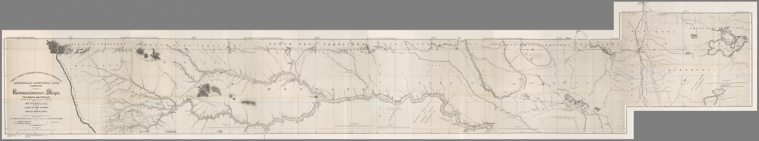
Full Title
United States Northern Boundary Commission. No. I, Reconnaissance Map. Archibald Campbell Esq., Commissioner. Reconnaissance Maps (Six Sheets and Profile) ... 49th Parallel from the Lake of the Woods to the Rocky Mountains. (Fort Shaw to Rocky Mountain Divide).
List No
2888.028
Author
[U.S. Northern Boundary Commission, Campbell, Archibald, Twining, W.J.]
Full Title
United States Northern Boundary Commission. No. II, Reconnaissance Map ... 49th Parallel. (Old Fort Browning to Sweet Grass Hills).
List No
2888.029
Author
[U.S. Northern Boundary Commission, Campbell, Archibald, Twining, W.J.]
Full Title
United States Northern Boundary Commission. No. III, Reconnaissance Map ... 49th Parallel. (Big Muddy River to Fort Hawley).
List No
2888.030
Author
[U.S. Northern Boundary Commission, Campbell, Archibald, Twining, W.J.]
Full Title
United States Northern Boundary Commission. No. IV, Reconnaissance Map ... 49th Parallel. (Mouse River to Fort Buford).
List No
2888.031
Author
[U.S. Northern Boundary Commission, Campbell, Archibald, Twining, W.J.]
Full Title
United States Northern Boundary Commission. No. V, Reconnaissance Map ... 49th Parallel. (Pembina Mountains to Mouse River).
List No
2888.032
Author
[U.S. Northern Boundary Commission, Campbell, Archibald, Twining, W.J.]
Full Title
United States Northern Boundary Commission. No. VI, Reconnaissance Map ... 49th Parallel. (Lake of the Woods to Ft. Pembina).
List No
2888.033
Author
[U.S. Northern Boundary Commission, Campbell, Archibald, Twining, W.J.]
Full Title
(Composite of) (Lake of the Woods to the Rocky Mountain Divide).
List No
2888.034
Author
[U.S. Northern Boundary Commission, Campbell, A.]
Full Title
(Covers to) Joint Maps Of The Northern Boundary Of The United States, From The Lake Of The Woods To The Summit Of The Rocky Mountains. United States Northern Boundary Commission, Archibald Campbell Esq. Commissioner. W.J. Twining, Capt. of Engrs, U.S.A. Chief Astronomer. Her Majesty's North American Boundary Commission, D.R. Cameron, Maj. Royal Art. Commissioner. S. Anderson, Capt. Royal Engrs. Chief Astronomer.
List No
3146.001
Note
Brown wrappers with title in black letters.
Author
[U.S. Northern Boundary Commission, Campbell, A.]
Full Title
(Title Page) Joint Maps Of The Northern Boundary Of The United States, From The Lake Of The Woods To The Summit Of The Rocky Mountains. United States Northern Boundary Commission, Archibald Campbell Esq. Commissioner. W.J. Twining, Capt. of Engrs, U.S.A. Chief Astronomer. Her Majesty's North American Boundary Commission, D.R. Cameron, Maj. Royal Art. Commissioner. S. Anderson, Capt. Royal Engrs. Chief Astronomer.
List No
3146.002
Note
Includes landscape vignette of Chief Mountain in present day Glacier National Park. The mountain appears on Sheet XXIV.
Author
[U.S. Northern Boundary Commission, Campbell, A.]
Full Title
Index Map, Joint Series. United States Northern Boundary Commission. Her Majesty's North American Boundary Commission.
List No
3146.003
Note
Relief shown in hachures.
Author
[U.S. Northern Boundary Commission, Campbell, A.]
Full Title
Joint Map No. I. United States Northern Boundary Commission. Her Majesty's North American Boundary Commission.
List No
3146.004
Note
Relief shown in hachures.
Author
[U.S. Northern Boundary Commission, Campbell, A.]
Full Title
Joint Map No. II. United States Northern Boundary Commission. Her Majesty's North American Boundary Commission.
List No
3146.005
Note
Relief shown in hachures.
Author
[U.S. Northern Boundary Commission, Campbell, A.]
Full Title
Joint Map No. III. United States Northern Boundary Commission. Her Majesty's North American Boundary Commission.
List No
3146.006
Note
Relief shown in hachures.
Author
[U.S. Northern Boundary Commission, Campbell, A.]
Full Title
Joint Map No. IV. United States Northern Boundary Commission. Her Majesty's North American Boundary Commission.
List No
3146.007
Note
Relief shown in hachures.
Author
[U.S. Northern Boundary Commission, Campbell, A.]
Full Title
Joint Map No. V. United States Northern Boundary Commission. Her Majesty's North American Boundary Commission.
List No
3146.008
Note
Relief shown in hachures.
Author
[U.S. Northern Boundary Commission, Campbell, A.]
Full Title
Joint Map No. VI. United States Northern Boundary Commission. Her Majesty's North American Boundary Commission.
List No
3146.009
Note
Relief shown in hachures.
|