|
Author
Herrera y Tordesillas, Antonio de, -1625
Full Title
(Title Page to) Descriptio Indiæ Occidentalis per Antonium de Herrera regium Indiarum et Castellæ historiographum.
List No
14476.005
Note
Title page to Descriptio Indiæ Occidentalis per Antonium de Herrera regium Indiarum et Castellæ historiographum, the first part of Nieuwe werelt anders ghenaempt West-Indien. Title translates to: A description of the West Indies by Antonius de Herrera, the royal historian of the Indies and Castile. Includes an engraved map of the Western Hemisphere, which features the earliest known published image California as an island, a cartographic myth that persisted until the 18th century. Decorated with engraved Castilian coat of arms, and eight vignettes showing Aztec gods and scenes of Nova Hispania [Mexico], including a temple.
Author
Le Maire, Jacques, 1585-1616
Full Title
(Title Page to) Spieghel der Australische navigatie, door dey wijt bermaerden ende cloeckmoedighen Zee-heldt / Jacob Maire, President ende Overste over de twee Schepen ... 14 Juni 1615. t'Amsterdam, by Michiel Colijn, Boeck-vercooper op't water, by de Dude Brugh, in't huys-boeck. Anno 1622.
List No
14476.021
Note
Title page to Spieghel der Australische navigatie, the third part of Nieuwe werelt anders ghenaempt West-Indien. Title translates (loosely) to: Southern navigation. Includes an engraved map of the world, featuring California as an island.
Author
Fremont, J.C.
Full Title
Map Of An Exploring Expedition To The Rocky Mountains in the Year 1842, Oregon & North California In The Years 1843-44. By Brevet Capt. J. C. Fremont Of The Corps Of Topographical Engineers Under the orders of Col. J.J. Abert, Chief Of The Topographical Bureau. Lith. by E. Weber & Co. Baltimore, Md.
List No
10280.000
Note
Senate Issue; map in case. See our 1833.001 for the House issue map which appears to be identical. Text has the astronomical observations that are not in the House issue. The large map of the west is one of the most interesting and beautiful government maps of the 1840's. It filled in many of the gaps in cartographic knowledge of the west. Charles Preuss was the cartographer. Map is without color except for a light blue for water areas.
Author
Fremont John Charles, 1813-1890
Full Title
Pass in the Sierra Nevada of California. Lith. by E. Weber & Co. Baltimore. (to accompany) Report of The Exploring Expedition to The Rocky Mountains in the Year 1842, and to Oregon & North California In The Years 1843-44. By Brevet Capt. J. C. Fremont ... Washington : Gales and Seaton, Printers. 1845.
List No
13406.021
Note
Lithograph map. Published by E. Weber & Co.
Author
Fremont John Charles, 1813-1890
Full Title
(Map of the crossing of the Sierra Nevada by the South Fork of the American River). Lith. by E. Weber & Co. Baltimore. (to accompany) Report of The Exploring Expedition to The Rocky Mountains in the Year 1842, and to Oregon & North California In The Years 1843-44. By Brevet Capt. J. C. Fremont ... Washington : Gales and Seaton, Printers. 1845.
List No
13406.022
Note
Untitled folding map of the crossing of the Sierra Nevada. Published by E. Weber & Co.
Author
Fremont John Charles, 1813-1890
Full Title
Fossil fresh water infusoria from Oregon. J. W. Bailey del. Lith. by E. Weber & Co. Baltimore. (to accompany) Report of The Exploring Expedition to The Rocky Mountains in the Year 1842, and to Oregon & North California In The Years 1843-44. By Brevet Capt. J. C. Fremont ... Washington : Gales and Seaton, Printers. 1845.
List No
13406.023
Note
24 lithograph views of fossil shells. Published by E. Weber & Co. In upper right margin: PL. V.
Author
Fremont John Charles, 1813-1890
Full Title
Fossil Ferns : Collection of the Geographical Survey of Oregon and North California. Lith. by E. Weber & Co. Baltimore. (to accompany) Report of The Exploring Expedition to The Rocky Mountains in the Year 1842, and to Oregon & North California In The Years 1843-44. By Brevet Capt. J. C. Fremont ... Washington : Gales and Seaton, Printers. 1845.
List No
13406.024
Note
8 lithograph views of fossil Ferns in 11 parts. Published by E. Weber & Co. In upper right margin: PL. I.
Author
Fremont John Charles, 1813-1890
Full Title
Fossil Ferns : Collection of the Geographical Survey of Oregon and North California. Lith. by E. Weber & Co. Baltimore. (to accompany) Report of The Exploring Expedition to The Rocky Mountains in the Year 1842, and to Oregon & North California In The Years 1843-44. By Brevet Capt. J. C. Fremont ... Washington : Gales and Seaton, Printers. 1845.
List No
13406.025
Note
5 lithograph views of fossil Ferns in 15 parts. Published by E. Weber & Co. In upper right margin: PL. II.
Author
Fremont John Charles, 1813-1890
Full Title
Fossil Ferns : Collection of the Geographical Survey of Oregon and North California. Lith. by E. Weber & Co. Baltimore. (to accompany) Report of The Exploring Expedition to The Rocky Mountains in the Year 1842, and to Oregon & North California In The Years 1843-44. By Brevet Capt. J. C. Fremont ... Washington : Gales and Seaton, Printers. 1845.
List No
13406.026
Note
14 lithograph views of fossil Ferns in 20 parts. Published by E. Weber & Co. In upper right margin: PL. III.
Author
Fremont John Charles, 1813-1890
Full Title
Fossil Shells : Collection of the Geographical Survey of Oregon and North California. Lith. by E. Weber & Co. Baltimore. (to accompany) Report of The Exploring Expedition to The Rocky Mountains in the Year 1842, and to Oregon & North California In The Years 1843-44. By Brevet Capt. J. C. Fremont ... Washington : Gales and Seaton, Printers. 1845.
List No
13406.027
Note
3 lithograph view. Published by E. Weber & Co. In upper right margin: Botany Plate IV.
Author
Fremont John Charles, 1813-1890
Full Title
Ardomecon Californicum. Lith. by E. Weber & Co. Baltimore. (to accompany) Report of The Exploring Expedition to The Rocky Mountains in the Year 1842, and to Oregon & North California In The Years 1843-44. By Brevet Capt. J. C. Fremont ... Washington : Gales and Seaton, Printers. 1845.
List No
13406.028
Note
Lithograph view. Published by E. Weber & Co. In upper right margin: Botany Plate II.
Author
Fremont John Charles, 1813-1890
Full Title
Prosopis odorata. Lith. by E. Weber & Co. Baltimore. (to accompany) Report of The Exploring Expedition to The Rocky Mountains in the Year 1842, and to Oregon & North California In The Years 1843-44. By Brevet Capt. J. C. Fremont ... Washington : Gales and Seaton, Printers. 1845.
List No
13406.029
Note
Lithograph view. Published by E. Weber & Co. In upper right margin: Botany Plate I.
Author
Fremont John Charles, 1813-1890
Full Title
Fremontia Vermicularis. Lith. by E. Weber & Co. Baltimore. (to accompany) Report of The Exploring Expedition to The Rocky Mountains in the Year 1842, and to Oregon & North California In The Years 1843-44. By Brevet Capt. J. C. Fremont ... Washington : Gales and Seaton, Printers. 1845.
List No
13406.030
Note
Lithograph view. Published by E. Weber & Co. In upper right margin: Botany Plate III.
Author
Fremont, J.C.
Full Title
(Title Page to) Report of The Exploring Expedition to The Rocky Mountains in the Year 1842, and to Oregon and North California in the Years 1843-'44.
List No
1833A
Author
Fremont, J.C.
Full Title
Map Of An Exploring Expedition To The Rocky Mountains in the Year 1842, Oregon & North California In The Years 1843-44. By Brevet Capt. J. C. Fremont Of The Corps Of Topographical Engineers Under the orders of Col. J.J. Abert, Chief Of The Topographical Bureau. Lith. by E. Weber & Co. Baltimore, Md.
List No
1833.001
Note
House Issue; map in case. Lacks the astronomical observations that appear in the first issue by the Senate. The large map of the west is one of the most interesting and beautiful government maps of the 1840's. It filled in many of the gaps in cartographic knowledge of the west. Charles Preuss was the cartographer. Fremont and Preuss mapped only what they saw along their routes, leaving large areas blank. Map is without color. Book is bound with full leather with "Executive Documents 2d Sess. 28th Cong." on the spine in gold.
Author
Fremont, J.C.
Full Title
(Title Page to) Geographical Memoir upon Upper California In Illustration of His Map of Oregon and California, by John Charles Fremont: Addressed to the Senate of the United States. Washington: Wendell and Van Benthuysen, Printers. 1848. [Senate.] 30th Congress, 1st Session. Miscellaneous. No. 148.
List No
1857A
Author
Fremont, J.C.
Full Title
Map Of Oregon And Upper California From the Surveys of John Charles Fremont And other Authorities. Drawn By Charles Preuss Under the Order of the Senate Of The United States, Washington City 1848. Lithy. by E. Weber & Co. Balto. (inset) Profile of the travelling route from the South Pass of the Rocky Mountains to the Bay of San Francisco.
List No
1857.001
Note
The map for the first time filled in the details of the Great Basin. Charles Preuss drew the map. A smaller version of the map appears in President Polk's Message of 1849 (see our copy). Report rebound with cloth covered boards and title on spine.
Author
[Ives, J.C., Mollhausen, H. B., Young, J. J.]
Full Title
Chimney Peak. Colorado Exploring Expedition frontispiece. J.J. Young from a sketch by H.B. Mollhausen. Lith. of Sarony, Major & Knapp, 449 Broadway, N.Y. In Charge. (Washington: Government Printing Office. 1861. Senate. 36th Congress, 1st Session. Ex. Doc.)
List No
0341B
Note
Lithographed view showing the peak (now called Picacho Peak), the boat "Explorer U.S." with crew, and Native Americans on the bank in the foreground. Has pencil annotation.
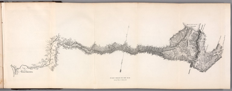
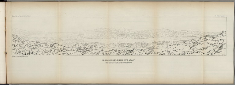
Author
Ives, J.C.
Full Title
Colorado River. Chemehuevis Valley, From Monument Mountains to Mojave Mountains. Colorado Exploring Expedition. Panoramic View No. 1. Drawn by Frhr. F.W. v. Ecloffstein.
List No
0341.015
Author
Ives, J.C.
Full Title
Fig 1. - Yuma Shoals.
List No
0341.016
Author
Ives, J.C.
Full Title
Fig 2. - Explorer's Pass.
List No
0341.017
Author
Ives, J.C.
Full Title
Fig 3. - Purple Hills.
List No
0341.018
Author
Ives, J.C.
Full Title
Cane Brake Canyon, from near Camp 16. Colorado Exploring Expedition. General Report - Plate II. J.J. Young from a sketch by F.W. Egloffstein. Lith Sarony, Major & Knapp, 449 Broadway N.Y.
List No
0341.019
Author
Ives, J.C.
Full Title
Fig 4. - Purple Hills Pass.
List No
0341.020
Author
Ives, J.C.
Full Title
Fig 5. - Red Rock Gate.
List No
0341.021
Author
Ives, J.C.
Full Title
Fig 6. - Sleeper's Bend.
List No
0341.022
Author
Ives, J.C.
Full Title
Fig 7. - Light-house Rock.
List No
0341.023
Author
Ives, J.C.
Full Title
Fig 8. - Riverside Mountains.
List No
0341.024
Author
Ives, J.C.
Full Title
Chemehuevis. Colorado Exploring Expedition. Indian Portraits, Plate III. B. Mollhausen, Del. Lith. of Sarony, Major & Knapp, 449 Broadway N.Y.
List No
0341.025
Note
Color.
Author
Ives, J.C.
Full Title
Fig 9. - Monument Mountains.
List No
0341.026
Author
Ives, J.C.
Full Title
Fig 10. - Corner Rock.
List No
0341.027
Author
Ives, J.C.
Full Title
Fig 11. - Monument Canyon.
List No
0341.028
Author
Ives, J.C.
Full Title
Fig 12. - Monument Range from the North.
List No
0341.029
Author
Ives, J.C.
Full Title
Fig 13. - Mount Whipple.
List No
0341.030
Author
Ives, J.C.
Full Title
Fig 14. - Remains of Grand Mesa in Chemehuevis Valley.
List No
0341.031
Author
Ives, J.C.
Full Title
Mojave Canon. Colorado Exploring Expedition. General Report, Plate III. J.J. Young from a sketch by H.B. Mollhausen, Del.
List No
0341.032
Author
Ives, J.C.
Full Title
Fig 15. - Mouth of Mojave Canon.
List No
0341.033
Note
Page has a large block of foxing.
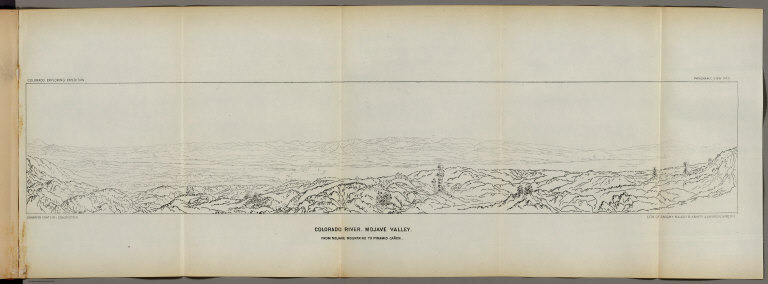
Author
Ives, J.C.
Full Title
Colorado River. Mojave Valley, From Mojave Mountains to Pyramid Canon. Colorado Exploring Expedition. Panoramic View No. 2. Drawn by Frhr. F.W. v. Ecloffstein. Lith. of Sarony Major & Knapp, 449 Broadway N.Y.
List No
0341.034
Author
Ives, J.C.
Full Title
Fig 16. - Head of Mojave Canon.
List No
0341.035
Author
Ives, J.C.
Full Title
Fig 1. Chimney Peak from the North.
List No
0341.081
Author
Ives, J.C.
Full Title
Fig 2. Spire Range.
List No
0341.082
Author
Ives, J.C.
Full Title
The Needles (Mojave Range). Colorado Exploring Expedition. Geology, Plate II. J.J. Young from a sketch by H.B. Mollhausen. Lith. of Sarcony, Major & Knapp, 449 Broadway N.Y.
List No
0341.086
Author
Ives, J.C.
Full Title
Fig 10. Section of Trough of Colorado at Elephant Hill.
List No
0341.090
Author
La Perouse, Jean-Francois de Galaup, comte de, 1741-1788
Full Title
Chart of Part of the North West Coast of America Explored by the Boussole & Astrolabe laid down conformally to the position of the Boussole every day at noon as determinined Astronomically by Mr. Dagelet. Published as the Act directs Novr. 1st 1798, by G.G. & J. Robinson, Paternoster Row. S. Neele, sculpt, Strand. No. 16.
List No
0414.016
Note
Engraved. Notes that shading indicates those portions of the coast viewed by la Perouse; the intervening reaches being completed from Spanish and English sources. Covers coast area from Monterey, California, (36 degrees north) to near Mt. St. Elias (61 degrees north), Alaska. Relief shown by hachures.
Author
La Perouse, Jean-Francois de Galaup, comte de, 1741-1788
Full Title
Chart of the North West Coast of America. Explored by the Boussole & Astrolabe in 1786. 3d. Sheet. Published as the Act directs Novr. 1st 1798, by G.G. & J. Robinson, Paternoster Row, London. No. 31.
List No
0414.031
Note
Engraved. Meridian Paris. Relief shown by hachures. Chart of the coast of California north from Monterey to Washington.
Author
La Perouse, Jean-Francois de Galaup, comte de, 1741-1788
Full Title
Plan of the Port of St. Francisco in California. Point de Reyes in 37 degrees 59 minutes of Latitude North & 124 degrees, 54 minutes Longitude - West. Published as the Act directs Novr. 1st 1798, by G.G. & J. Robinson, Paternoster Row, London. Neele, sculpt., Strand. No. 33.
List No
0414.033
Note
Engraved. Legend keyed by letter to 21 features on map. Soundings in Spanish fathoms.
Author
La Perouse, Jean-Francois de Galaup, comte de, 1741-1788
Full Title
Plan of the Bay of Monterey, Situate in North California, in 36 degrees 38 minutes of Latitude North & 124 degrees, 3 minutes Longitude - West, to Illustrate the Voyage of La Perouse. Published as the Act directs Novr. 1st 1798, by G.G. & J. Robinson, Pater-noster Row, London. S. Neele, sculpt., Strand. No. 34.
List No
0414.034
Note
Engraved. Relief shown with hachures. Shows mission, sand dunes, anchorage, presidio, and Carmel River.
Author
La Perouse, Jean-Francois de Galaup, comte de, 1741-1788
Full Title
(Two charts) Plan of the Port of S. Diego in California. Situate in in 32 degrees 39 minutes 0 seconds of Latitude North & 12 degrees, 4 minutes 0 seconds West of St. Blas from a Survey in 1782 .... Plan of the Port and Department of S. Blas, Situate 21 degrees 30 minutes of Latitude Nth. & 88 degrees 15 minutes 0 seconds _ West of Tenefriffe and 107 degrees 15 minutes 0 seconds _ West of Paris from a Survey in november 1877. Published as the Act directs Novr. 1st 1798, by G.G. & J. Robinson, Paternoster Row, London. S. Neele, sculpt., Strand. No. 35.
List No
0414.035
Note
Engraved. Relief shown with hachures. Shows rancherias, soundings, marsh, town, roads.
Author
La Perouse, Jean-Francois de Galaup, comte de, 1741-1788
Full Title
Male & Female Partridge of California. Published as the Act directs Novr. 1st 1798, by G.G. & J. Robinson, Pater Noster Row, London. Prevost, del. Heath, sculp., Strand. No. 36.
List No
0414.036
Note
Engraved. Bird illustration: California quail, the official state bird.
Author
La Perouse, Jean-Francois de Galaup, comte de, 1741-1788
Full Title
Promerops or Bee-Eater of California. Published as the Act directs Novr. 1st 1798, by G.G. & J. Robinson, Pater Noster Row, London. Prevost, Junr. delt. No. 37.
List No
0414.037
Note
Engraved. Bird illustration: California thrasher.
|