|
Author
Ives, J.C.
Full Title
Fig 17. Volcanic Cones East of the San Francisco Mountain.
List No
0341.099
Author
Ives, J.C.
Full Title
Fig 18. Mesa Walls of Red Sandstone.- Painted Desert.
List No
0341.100
Author
Ives, J.C.
Full Title
Fig 19. Section of Mesa between the Little Colorado and Moqui Villages.
List No
0341.101
Author
Ives, J.C.
Full Title
Fig 20. Eroded Sandstone, near the Moqui Villages (Camp 92).
List No
0341.102
Author
Ives, J.C.
Full Title
Fig 21. An Outlier of the Cretaceous Mesa, Moqui Villages.
List No
0341.103
Author
Ives, J.C.
Full Title
Fig 22. Distant View of Great White Mesa, from near Camp 96.
List No
0341.104
Author
Ives, J.C.
Full Title
Fig 23. Monument in Eroded Valley, near Camp 100.
List No
0341.105
Author
Ives, J.C.
Full Title
Fig 24. Natural Bridge, Camp 100.
List No
0341.106
Author
Ives, J.C.
Full Title
Fig 25. Masses of White Calcareous Sandstone Shaped by Erosion, near Camp 100.
List No
0341.107
Author
Ives, J.C.
Full Title
Fig 26. Section of the Valley at Fort Defiance.
List No
0341.108
Author
Ives, J.C.
Full Title
Fig 27. Section of Dislocated Strata at Salt Spring.
List No
0341.109
Author
Ives, J.C.
Full Title
Explanation of Plate I. Paleontology. Plate I.
List No
0341.110
Author
Ives, J.C.
Full Title
Explanation of Plate II. Paleontology. Plate II.
List No
0341.111
Author
Ives, J.C.
Full Title
Explanation of Plate III. Paleontology. Plate III.
List No
0341.112
Author
Ives, J.C.
Full Title
Geological Map No. 1. Prepared by J.S. Newberry, M.D. Geologist to the Expedition. Explorations and Surveys. War Department. Map No. 1. Rio Colorado of the West, explored by 1st Lieut. Joseph C. Ives, Topl. Engrs. under the direction of the Office of Explorations and Surveys. A.A. Humphreys, Capt. Topl. Engrs. in Charge, by order of the Hon. John B. Floyd, Secretary of War. 1858. Drawn by Frhr. F.W.v. Egloffstein. Topographer to the Expedition. Topography by Frhr. F.W.v. Egloffstein. Ruling by Samuel Sartain. Lettering by F. Courtenay.
List No
0341.003
Note
Color washed map in four parts across the page with the title on the far right map, with the maps reading from right to left. The detail of the map is superb, and shows the course of the Colorado River from its headwaters to the Gulf of California.
Author
Ives, J.C.
Full Title
Geological Map No. 2. Prepared by J.S. Newberry, M.D. Geologist to the Expedition. Explorations and Surveys. War Department. Map No. 1. Rio Colorado of the West, explored by 1st Lieut. Joseph C. Ives, Topl. Engrs. under the direction of the Office of Explorations and Surveys. A.A. Humphreys, Capt. Topl. Engrs. in Charge, by order of the Hon. John B. Floyd, Secretary of War. 1858. Drawn by Frhr. F.W.v. Egloffstein. Topographer to the Expedition. Topography by Frhr. F.W.v. Egloffstein. Ruling by Samuel Sartain. Lettering by F. Courtenay.
List No
0341.004
Note
Color washed map showing the Grand Canyon in superb detail with geological information included. A key is added below the map. The "line of exploration" and camps are shown.
Author
Ives, J.C.
Full Title
Appendix D. Remarks upon the Construction of the Maps.
List No
0341.113
Author
[Pacific Railroad Survey, Warren, Gouverneur Kemble, 1830-1882]
Full Title
(Covers to) Reports of Explorations and Surveys, to Ascertain the Most Practicable and Economical Route for a Railroad From the Mississippi River to the Pacific Ocean. Made Under the Direction of the Secretary of War, In 1853-56, According to Acts of Congress of March 3, 1853, May 31, 1854, and August 5, 1854. Volume XI. Washington: George W. Bowman, Printer. 1861. 36th Congress, 2d Session, Senate, Ex. Doc.
List No
0693A
Author
[Pacific Railroad Survey, Warren, Gouverneur Kemble, 1830-1882]
Full Title
(Title Page to) Reports of Explorations and Surveys, to Ascertain the Most Practicable and Economical Route for a Railroad From the Mississippi River to the Pacific Ocean. Made Under the Direction of the Secretary of War, In 1853-56, According to Acts of Congress of March 3, 1853, May 31, 1854, and August 5, 1854. Volume XI. Washington: George W. Bowman, Printer. 1861. 36th Congress, 2d Session, Senate, Ex. Doc.
List No
0693B
Note
This Quarto issue of the report is the House issue, except for volume XI which is the Senate issue. W. Heckrotte has an unusual copy of the Warren U.S. map found in this report. It is dissected on linen and is an earlier version of the map published with the Quarto report. It has 40 authorities vs. 42 in the quarto issue map, shorter note to left of authorities, lots of plate differences, especially: nothing in Owyhee area, differences in N.M., Calif., etc. Looks like someone asked for the map before it was finished -see the Lack of ocean lines in the top half south of Gray's Harbor. In 13 volumes. Bound in full leather with "Explorations and Surveys for a Railroad to the Pacific Ocean" and the volume number on the spine in gold.
Author
[Pacific Railroad Survey, Warren, Gouverneur Kemble, 1830-1882]
Full Title
(Contents Page to) Reports of Explorations and Surveys, to Ascertain the Most Practicable and Economical Route for a Railroad From the Mississippi River to the Pacific Ocean. Made Under the Direction of the Secretary of War, In 1853-56, According to Acts of Congress of March 3, 1853, May 31, 1854, and August 5, 1854. Volume XI. Washington: George W. Bowman, Printer. 1861. 36th Congress, 2d Session, Senate, Ex. Doc.
List No
0693C
Note
"Contents of volume XI."
Author
[Pacific Railroad Survey, Warren, Gouverneur Kemble, 1830-1882]
Full Title
(Title Page to) Memoir to accompany the Map of the territory of the United States from the Mississippi River to the Pacific Ocean, giving a brief account of each of the exploring expeditions since A.D. 1800, with a detailed description of the method adopted in compiling the general map. By Lieut. Gouverneur K. Warren, Corps of Topographical Engineers, U.S.A. 1859.
List No
0693D
Author
[Pacific Railroad Survey, Warren, Gouverneur Kemble, 1830-1882]
Full Title
(Contents Page to) Memoir to accompany the Map of the territory of the United States from the Mississippi River to the Pacific Ocean, giving a brief account of each of the exploring expeditions since A.D. 1800, with a detailed description of the method adopted in compiling the general map. By Lieut. Gouverneur K. Warren, Corps of Topographical Engineers, U.S.A. 1859.
List No
0693E
Note
"List of illustrations."
Author
[Pacific Railroad Survey, Warren, Gouverneur Kemble, 1830-1882, Winterbotham, W.]
Full Title
Reduced section of a general map of North America. Drawn from the best surveys. 1795. To accompany Winterbotham's History. Published by John Reid, New York. Lith of J. Bien, 60 Fulton St., N.Y. U.S. Pacific R.R. Exp. & Surveys. Lt. Warren's Memoir Plate I. (1861)
List No
0693.001
Note
Lithographed map. Relief shown pictorially.
Author
[Pacific Railroad Survey, Warren, Gouverneur Kemble, 1830-1882]
Full Title
Reduced section of a sketch of the western part of the continent of North America between latitudes 35 (degrees) and 52 (degrees) Nth. 1818. Lith of J. Bien, 60 Fulton St., N.Y. U.S. Pacific R.R. Exp. & Surveys. Lt. Warren's Memoir Plate II. (1861)
List No
0693.002
Note
Lithographed map. Relief shown by hachures.
Author
[Pacific Railroad Survey, Warren, Gouverneur Kemble, 1830-1882]
Full Title
Reduced section of map of North America including all the recent geographical discoveries. 1826. Lith of J. Bien, 60 Fulton St., N.Y. U.S. Pacific R.R. Exp. & Surveys. Lt. Warren's Memoir Plate III. (1861)
List No
0693.003
Note
Lithographed map. Relief shown by hachures.
Author
[Bonneville, Benjamin Louis Eulalie de, Pacific Railroad Survey, Warren, Gouverneur Kemble, 1830-1882]
Full Title
Reduced map of the territory west of the Rocky Mountains. By Capt. B.L.E. Bonneville, U.S.A. 1837. Lith of J. Bien, 60 Fulton St., N.Y. U.S. Pacific R.R. Exp. & Surveys. Lt. Warren's Memoir Plate IV. (1861)
List No
0693.004
Note
Lithographed map. Relief shown by hachures.
Author
[Pacific Railroad Survey, Warren, Gouverneur Kemble, 1830-1882]
Full Title
(Title Page to) Topographical maps, profiles, and sketches to illustrate the various Reports of Surveys for railroad routes from the Mississippi River to the Pacific Ocean. Washington, D.C., 1861.
List No
0693F
Author
[Pacific Railroad Survey, Warren, Gouverneur Kemble, 1830-1882]
Full Title
(Contents Page to) Topographical maps, profiles, and sketches to illustrate the various Reports of Surveys for railroad routes from the Mississippi River to the Pacific Ocean. Washington, D.C., 1861.
List No
0693G
Author
[Pacific Railroad Survey, Warren, Gouverneur Kemble, 1830-1882]
Full Title
(Contents Page to) Topographical maps, profiles, and sketches to illustrate the various Reports of Surveys for railroad routes from the Mississippi River to the Pacific Ocean. Washington, D.C., 1861.
List No
0693H
Author
[Beckwith, Lieut., Schumann, C.]
Full Title
Weber Lower Canyon. April 5th at 2 P.M. from an island in Weber River; Valley of Great Salt Lake. C. Schumann from F.W. Egloffstein. Selmar Siebert's Engraving & Printing Establishment, Washington, D.C. U.S.P.R.R. Exp. & Surveys 41st Parallel. Expl. by Lieut. Beckwith. Vol. II.
List No
0693.005
Note
View without color. The "Wah-satch Mountains" are in the background.
Author
[Beckwith, Lieut., Hinshelwood, R., Schumann, C.]
Full Title
Second or Sheeprock Canyon of Weber River. April 6th at 1 P.M. View Looking East. C. Schumann from F.W. Egloffstein. R. Hinshelwood. U.S.P.R.R. Exp. & Surveys 41st Parallel. Expl. by Lieut. Beckwith. Vol. II.
List No
0693.006
Note
View uncolored.
Author
[Beckwith, Lieut., Schumann, C.]
Full Title
Porcupine Terrace. Uintah Mountains in the Distance. Camp. April 16th to 17th. C. Schumann from F.W. Egloffstein. Selmar Siebert's Engraving & Printing Establishment, Washington, D.C. U.S.P.R.R. Exp. & Surveys 41st Parallel. Expl. by Lieut. Beckwith. Vol. II.
List No
0693.007
Note
Uncolored engraving shows the Bear River and the Uintah Mountains.
Author
[Beckwith, Lieut., Schumann, C.]
Full Title
Round Prairie From Head of the Same. April 21st at 10 A.M. C. Schumann from F.W. Egloffstein. S.V. Hunt Sc. U.S.P.R.R. Exp. & Surveys 41st Parallel. Expl. by Lieut. Beckwith. Vol. II.
List No
0693.008
Note
Uncolored view includes the Timpanogos River and Canyon.
Author
[Beckwith, Lieut., Schumann, C.]
Full Title
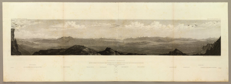
Goshoot Passage showing 65 miles of the proposed line of railroad from the desert west of Great Salt Lake to the Humboldt Mountains. May 17th-20th. C. Schumann from F.W. Egloffstein. Selmar Siebert's Engraving & Printing Establishment, Washington, D.C. U.S.P.R.R. Exp. & Surveys 41st Parallel. Expl. by Lieut. Beckwith. Vol. II.
List No
0693.009
Note
Uncolored view includes Don-Don Mountain, Wa-cho-i Mountain, Mo-ko-ga-ri Butte, the Wa-ro-ja Mountains, Franklin valley and lake, and the eastern foot of the Humboldt Mountains.
Author
[Beckwith, Lieut., Schumann, C.]
Full Title
Humboldt Pass. May 22nd at 12 A.M. from high peak east of pass. C. Schumann from F.W. Egloffstein. Selmar Siebert's Engraving & Printing Establishment, Washington, D.C. U.S.P.R.R. Exp. & Surveys 41st Parallel. Expl. by Lieut. Beckwith. Vol. II.
List No
0693.010
Note
View uncolored. Included are the Franklin River, the distant snowy divide of the Humboldt and Columbia Rivers, and the Humboldt valley.
Author
[Beckwith, Lieut., Schumann, C.]
Full Title
Franklin Valley. May 24th at 10 A.M. from a spur of the Humboldt Mountains. C. Schumann from F.W. Egloffstein. Selmar Siebert's Engraving & Printing Establishment, Washington, D.C. U.S.P.R.R. Exp. & Surveys 41st Parallel. Expl. by Lieut. Beckwith. Vol. II.
List No
0693.011
Note
Uncolored view.
Author
[Beckwith, Lieut., Schumann, C.]
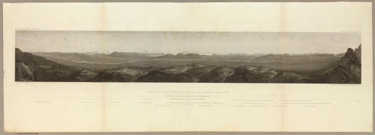
Full Title
Valley of the Humboldt River at Lassen's Meadows. June 9th at 3 P.M. from a peak on the western Humboldt River range. C. Schumann from F.W. Egloffstein. Selmar Siebert's Engraving & Printing Establishment, Washington, D.C. U.S.P.R.R. Exp. & Surveys 41st Parallel. Expl. by Lieut. Beckwith. Vol. II.
List No
0693.012
Note
An uncolored extended view of the Lassen valley. The Sierra Nevadas and the upper Sacramento River can be seen in the background.
Author
[Beckwith, Lieut., Schumann, C.]
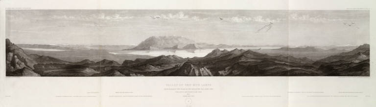
Full Title
Valley of the Mud Lakes showing eighty two miles of the projected rail road line. June 14th at 9 A.M. from Mud Lake peak. C. Schumann from F.W. Egloffstein. Selmar Siebert's Engraving & Printing Establishment, Washington, D.C. U.S.P.R.R. Exp. & Surveys 41st Parallel. Expl. by Lieut. Beckwith. Vol. II.
List No
0693.013
Note
Uncolored view including the eastern base of the Sierra Nevadas and the Oregon road entering the Sierra Nevada.
Author
[Beckwith, Lieut., Schumann, C.]
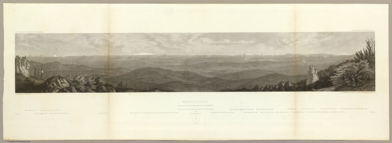
Full Title
Madelin Pass. June 19th at 2 P.M. view taken from Mount Observation. C. Schumann from F.W. Egloffstein. Selmar Siebert's Engraving & Printing Establishment, Washington, D.C. U.S.P.R.R. Exp. & Surveys 41st Parallel. Expl. by Lieut. Beckwith. Vol. II.
List No
0693.014
Note
Uncolored view showing the stretch looking east from Mt. Shasta to the Sierras west of Pyramid Lake.
Author
[Beckwith, Lieut., Schumann, C.]
Full Title
West End of Madelin Pass. June 26th at 8 A.M. from a peak overlooking Madelin Creek. C. Schumann from F.W. Egloffstein. Selmar Siebert's Engraving & Printing Establishment, Washington, D.C. U.S.P.R.R. Exp. & Surveys 41st Parallel. Expl. by Lieut. Beckwith. Vol. II.
List No
0693.015
Note
Uncolored view to the north showing the Sacramento River descending through the Round Valley. Mt. Shasta is shown in the background.
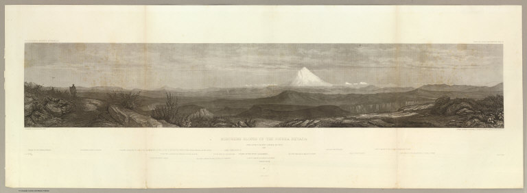
Author
[Beckwith, Lieut., Schumann, C.]
Full Title
Northern Slopes of the Sierra Nevada. June 30th at 9 A.M. view towards the West 1854. C. Schumann from F.W. Egloffstein. Selmar Siebert's Engraving & Printing Establishment, Washington, D.C. U.S.P.R.R. Exp. & Surveys 41st Parallel. Expl. by Lieut. Beckwith. Vol. II.
List No
0693.016
Note
View uncolored. The center of the view is dominated by Mt. Shasta, 50 miles in the distance. The view is looking to the west with the Coast Range 100 miles in the distance.
Author
[Beckwith, Lieut., Schumann, C.]
Full Title
Portion of the main mountain passage of the upper Sacramento or Pitt River. July 20th at 1 P.M. 25 miles south of Mt. Shasta. C. Schumann from F.W. Egloffstein. Selmar Siebert's Engraving & Printing Establishment, Washington, D.C. U.S.P.R.R. Exp. & Surveys 41st Parallel. Expl. by Lieut. Beckwith. Vol. II.
List No
0693.017
Note
Uncolored view looking to Mt. Shasta in the north.
Author
Warren, Gouverneur Kemble, 1830-1882
Full Title
Map Of The Territory Of The United States From The Mississippi To The Pacific Ocean Ordered by the Hon. Jeff'n Davis, Secretary Of War To accompany the Reports of the Explorations For A Railroad Route ... Compiled from authorized explorations and other reliable data by Lieut. G.K. Warren, Topl. Engrs. In the Office of Pacific R.R. Surveys, War Dep. under the direction of Bvt. Maj. W.H. Emory, Topl Engrs. in 1854 and of Capt. A.A. Humphreys, Topl. Engrs. 1854-5-6-7. Engr. by Selmar Siebert.
List No
0693.018
Note
The general map published with the Pacific Railroad Survey Reports. This map had earlier issues and later issues. A preliminary listed of those would be: 1855 (our #2289); 1857 (WH and AH's copies)- blank areas in eastern Oregon, fewer authorities; 1857 published with the reports; 1858 early (see Schubert);1858 late (our #2750); 1867 (our #2594). We suspect there are other states and issues, particularly in the period of 1859 to 1866. This is one of the most important maps of the West in the 1850's and 1860's and a study of its different states shows the rapid growth of topographical information from government exploration and mapping. Without color.
Author
[Abbot, Henry L., Humphreys, A.A., Warren, Gouverneur Kemble, 1830-1882]
Full Title
Profiles of the main routes surveyed, compiled in 1855, by Lieutenants G.K. Warren & H.L. Abbot, Corps Topl. Engineers; with revisions and additional compilations from the results of subsequent examinations and surveys. Prepared in the Office of Pacific Rail Road Explorations and Surveys. Captain A.A. Humphreys, Corps Topl. Engineers, in charge, by direction of Hon. Jefferson Davis, Secretary of War. 1856. Explorations and Surveys for the Rail Road Routes from the Mississippi River to the Pacific Ocean, War Department. (with) Profiles of rail roads constructed across the Alleghany mountains.
List No
0693.019
Note
Uncolored map profiles with inset profile. Printed on 2 sheets; joined as 1.
Author
Stevens, Isaac I.
Full Title
St. Paul to Riviere Des Lacs; from Explorations and Surveys made under the direction of the Hon. Jefferson Davis Secretary of War by Isaac I. Stevens, Governor of Washington Territory. 1853-4. Explorations and surveys for a railroad route from the Mississippi River to the Pacific Ocean. War Department. Route near the 47th and 49th parallels. Map No. 1.
List No
0693.020
Note
Uncolored map stretching from St. Paul into North Dakota.
Author
Stevens, Isaac I.
Full Title
Riviere Des Lacs to the Rocky Mountains; from Explorations and Surveys made under the direction of the Hon. Jefferson Davis Secretary of War by Isaac I. Stevens, Governor of Washington Territory 1853-4. Explorations and surveys for a railroad route from the Mississippi River to the Pacific Ocean. War Department. Route near the 47th and 49th parallels. Map No. 2. Engr. by Selmar Siebert.
List No
0693.021
Note
Uncolored map covering the area from Fort Pierre (South Dakota) on the Missouri River to the foot of the Rocky Mountains near present-day Helena, Montana.
Author
Stevens, Isaac I.
Full Title
Rocky Mountains to Puget Sound; from Explorations and Surveys made under the direction of the Hon. Jefferson Davis Secretary of War by Isaac I. Stevens, Governor of Washington Territory 1853-4. Explorations and surveys for a railroad route from the Mississippi River to the Pacific Ocean. War Department. Route near the 47th and 49th parallels. Map No. 3. Engr. by Selmar Siebert.
List No
0693.022
Note
Map covers the area from the ridge of the Rocky Mountains in Montana to Puget Sound and the Pacific Ocean. Inset map titled "Reconnaissance of the Railroad Route from Wallawalla to Seattle via Yak-e-mah River & Snoqualmie Pass. By A.W. Tinkham in January 1854."
Author
Stevens, Isaac I.
Full Title
Routes near the 47th and 49th parallels. Profiles: from explorations and surveys made under the direction of Hon. Jefferson Davis, Secretary of War by Isaac I. Stevens, Gov. of Washington Territory. 1853-4. (1861)
List No
0693.023
Note
Uncolored profiles. Vertical scale 1:60,000.
Author
Williamson, R.S.
Full Title
From San Francisco Bay to the Northern Boundary of California from Explorations and Surveys made under the direction of the Hon. Jefferson Davis Secretary of War by Lieut. R.S. Williamson, U.S. Topl. Engrs. and Lieut. H.L. Abbot, U.S. Topl. Engrs., H.C. Fillebrown, J. Young and C.D. Anderson, Assts. 1855. Explorations and surveys for a railroad route from the Mississippi River to the Pacific Ocean. War Department. Routes in Oregon and California. Map No. 1. Drawn by John Young.
List No
0693.024
Note
Map extends north from the tip of the San Francisco Bay to the 42nd parallel. The areas around the bay and the northern section near Lassen and Mt. Shasta are the most extensively drawn. Uncolored. List of authorities included.
Author
Williamson, R.S.
Full Title
From the Northern Boundary of California to the Columbia River from Explorations and Surveys made under the direction of the Hon. Jefferson Davis Secretary of War by Lieut. R.S. Williamson, U.S. Topl. Engrs. and Lieut. H.L. Abbot, U.S. Topl. Engrs., H.C. Fillebrown, J. Young and C.D. Anderson, Assts. 1855. Explorations and surveys for a railroad route from the Mississippi River to the Pacific Ocean. War Department. Routes in Oregon and California. Map No. 2. Drawn by John Young. Engd. by Selmar Siebert.
List No
0693.025
Note
Uncolored map covering the area from the 42nd parallel to the mouth of the Columbia River. Includes a list of the other surveys referenced.
|