|
Author
MacKenzie, Alexander
Full Title
(Covers to) Voyages from Montreal, on the River St. Laurence, Through the Continent of North America, To The Frozen And Pacific Oceans; In the Years 1789 and 1793. With a Preliminary Account of the Rise, Progress, and Present State of The Fur Trade of that Country. Illustrated with Maps. By Alexander Mackenzie, Esq. London: Printed for T. Cadell, Jun. and W. Davies, Strand; Cobbett and Morgan, Pall-Mall; and W. Creech, at Edinburgh. By R. Noble, Old-Bailey. M.DCCC.I.
List No
0449.001
Author
MacKenzie, Alexander
Full Title
Alexander MacKenzie Esq.
List No
0449.002
Author
MacKenzie, Alexander
Full Title
(Title page to) Voyages from Montreal, on the River St. Laurence, Through the Continent of North America, To The Frozen And Pacific Oceans; In the Years 1789 and 1793. With a Preliminary Account of the Rise, Progress, and Present State of The Fur Trade of that Country. Illustrated with Maps. By Alexander Mackenzie, Esq. London: Printed for T. Cadell, Jun. and W. Davies, Strand; Cobbett and Morgan, Pall-Mall; and W. Creech, at Edinburgh. By R. Noble, Old-Bailey. M.DCCC.I.
List No
0449.003
Author
[MacKenzie, Alexander, Arrowsmith, Aaron]
Full Title
A Map of America, between Latitudes 40 and 70 North, and Longitudes 45 and 180 West. Exhibiting Mackenzie's Track From Montreal to Fort Chipewyan & from thence to the North Sea. In 1789, & to the West Pacific Ocean in 1793.
List No
0449.004
Note
Engraved by Aaron Arrowsmith and reduced from his A map exhibiting all the new discoveries in the interior parts of North America. Cf. Mackenzie, A. Voyages from Montreal on the river St. Laurence ... London, 1801, p. vii at beginning Relief shown by hachures Details Alexander Mackenzie's overland routes across Canada, including the 1789 Mackenzie River expedition to the Arctic Ocean and the 1792-1793 Peace River expedition to the Pacific Ocean Identifies Indian tribal regions State 1. Cf. Stuart-Stubbs
Author
MacKenzie, Alexander
Full Title
A Map of Mackenzie's Track, from Fort Chipewyan to the North Sea, in 1789
List No
0449.005
Author
MacKenzie, Alexander
Full Title
A Map of Mackenzie's Track, from Fort Chipewyan to the Pacific Ocean in 1793.
List No
0449.006
Author
[Herrera y Tordesillas, Antonio de, -1625, Ordóñez de Ceballos, Pedro, approximately 1545-approximately 1630, Le Maire, Jacques, 1585-1616]
Full Title
(Covers to) [Nieuwe werelt anders ghenaempt West-Indien. t'Amsterdam, by Michiel Colijn, Boeck-vercooper op't water by de oude brugh, in't huys-boeck. Anno 1622.]
List No
14476.001
Note
Covers to Nieuwe werelt anders ghenaempt West-Indien. Bound in vellum-covered board.
Author
Herrera y Tordesillas, Antonio de, -1625
Full Title
(Title Page to) Descriptio Indiæ Occidentalis per Antonium de Herrera regium Indiarum et Castellæ historiographum.
List No
14476.005
Note
Title page to Descriptio Indiæ Occidentalis per Antonium de Herrera regium Indiarum et Castellæ historiographum, the first part of Nieuwe werelt anders ghenaempt West-Indien. Title translates to: A description of the West Indies by Antonius de Herrera, the royal historian of the Indies and Castile. Includes an engraved map of the Western Hemisphere, which features the earliest known published image California as an island, a cartographic myth that persisted until the 18th century. Decorated with engraved Castilian coat of arms, and eight vignettes showing Aztec gods and scenes of Nova Hispania [Mexico], including a temple.
Author
Herrera y Tordesillas, Antonio de, -1625
Full Title
Descripcion de las Indias Ocidentalis.
List No
14476.006
Note
Map of the Western Hemisphere, featuring the West Indies. Shows countries, cities, topography, bodies of water, drainage, coastlines and islands. Relief shown pictorially. Includes latitudinal lines and longitudinal lines, as well as a descriptive note. Black and white engraving. Map is 23 x 32 cm, on double sheet 29 x 36 cm. Appears in Descriptio Indiae Occidentalis per Antonium de Herrera regium Indiarum et Castellae historiographum, the first part of Nieuwe werelt anders ghenaempt West-Indien. (Plate number inferred.)
Author
Herrera y Tordesillas, Antonio de, -1625
Full Title
Descripçion de las Indias del Norte.
List No
14476.007
Note
Map of the West Indies. Shows countries, audiencias (royal courts in Spanish colonial America), bodies of water, drainage, coastlines and islands. Includes latitudinal lines and longitudinal lines, as well as descriptive notes. Black and white engraving. Map is 21 x 29 cm, on double sheet 29 x 36 cm. Appears in Descriptio Indiae Occidentalis per Antonium de Herrera regium Indiarum et Castellae historiographum, the first part of Nieuwe werelt anders ghenaempt West-Indien.
Author
Herrera y Tordesillas, Antonio de, -1625
Full Title
Description del destricto del audiencia de la Española.
List No
14476.008
Note
Map of Hispaniola. Shows countries, regions, cities, bodies of water, drainage, coastlines, shoals and islands. Includes latitudinal lines and longitudinal lines. Indexed to indicate city names. Black and white engraving. Map is 21 x 29 cm, on double sheet 29 x 36 cm. Appears in Descriptio Indiae Occidentalis per Antonium de Herrera regium Indiarum et Castellae historiographum, the first part of Nieuwe werelt anders ghenaempt West-Indien.
Author
Herrera y Tordesillas, Antonio de, -1625
Full Title
Descripçion del destricto del audiencia de Nueva Espana.
List No
14476.009
Note
Map of Nueva Espana [New Spain] (current-day southern Mexico). Shows regions, cities, topography, bodies of water, drainage, coastlines and islands. Relief shown pictorially. Includes a descriptive note. Black and white engraving. Map is 21 x 29 cm, on double sheet 29 x 36 cm. Appears in Descriptio Indiae Occidentalis per Antonium de Herrera regium Indiarum et Castellae historiographum, the first part of Nieuwe werelt anders ghenaempt West-Indien.
Author
Herrera y Tordesillas, Antonio de, -1625
Full Title
Descripcion del destricto del audiencia de la Nueva Galicia.
List No
14476.010
Note
Map of Nueva Galicia [New Galicia] (current-day southern Mexico). Shows regions, cities, topography, bodies of water, drainage, coastlines and islands. Relief shown pictorially. Includes a descriptive note. Black and white engraving. Map is 21 x 29 cm, on double sheet 29 x 36 cm. Appears in Descriptio Indiae Occidentalis per Antonium de Herrera regium Indiarum et Castellae historiographum, the first part of Nieuwe werelt anders ghenaempt West-Indien.
Author
Herrera y Tordesillas, Antonio de, -1625
Full Title
Descripcion del audiencia de Guatimala.
List No
14476.011
Note
Map of Guatemala. Shows countries, regions, cities, topography, bodies of water, drainage, coastlines, shoals and islands. Relief shown pictorially. Black and white engraving. Map is 21 x 29 cm, on double sheet 29 x 36 cm. Appears in Descriptio Indiae Occidentalis per Antonium de Herrera regium Indiarum et Castellae historiographum, the first part of Nieuwe werelt anders ghenaempt West-Indien.
Author
Herrera y Tordesillas, Antonio de, -1625
Full Title
Descripcion de las Indias de Mediodia.
List No
14476.012
Note
Map of South America. Shows countries, regions, topography, bodies of water, drainage, coastlines, shoals and islands. Relief shown pictorially. Includes latitudinal and longitudinal lines. Black and white engraving. Map is 21 x 29 cm, on double sheet 29 x 36 cm. Appears in Descriptio Indiae Occidentalis per Antonium de Herrera regium Indiarum et Castellae historiographum, the first part of Nieuwe werelt anders ghenaempt West-Indien.
Author
Herrera y Tordesillas, Antonio de, -1625
Full Title
Descripcion del audiencia de Panama.
List No
14476.013
Note
Map of Panama. Shows regions, cities, bodies of water, drainage, coastlines and islands. Includes descriptive notes. Black and white engraving. Map is 21 x 29 cm, on double sheet 29 x 36 cm. Appears in Descriptio Indiae Occidentalis per Antonium de Herrera regium Indiarum et Castellae historiographum, the first part of Nieuwe werelt anders ghenaempt West-Indien.
Author
Herrera y Tordesillas, Antonio de, -1625
Full Title
Descripcion del audiencia del Nuevo Reino.
List No
14476.014
Note
Map of Nuevo Reino ["New Kingdom"] (current-day northwestern Venezuela). Shows regions, cities, bodies of water, drainage, coastline and islands. Includes descriptive notes. Black and white engraving. Map is 21 x 29 cm, on double sheet 29 x 36 cm. Appears in Descriptio Indiae Occidentalis per Antonium de Herrera regium Indiarum et Castellae historiographum, the first part of Nieuwe werelt anders ghenaempt West-Indien.
Author
Herrera y Tordesillas, Antonio de, -1625
Full Title
Descripcion del audiencia del Quito.
List No
14476.015
Note
Map of Quito and vicinity, Ecuador. Shows regions, topography, cities, bodies of water, drainage, coastline and islands. Relief shown pictorially. Includes descriptive notes. Black and white engraving. Map is 21 x 29 cm, on double sheet 29 x 36 cm. Appears in Descriptio Indiae Occidentalis per Antonium de Herrera regium Indiarum et Castellae historiographum, the first part of Nieuwe werelt anders ghenaempt West-Indien.
Author
Herrera y Tordesillas, Antonio de, -1625
Full Title
Descripcion del destrieto del audiencia de Lima.
List No
14476.016
Note
Map of Lima and vicinity, Peru. Shows regions, cities, topography, bodies of water, drainage, coastline and islands. Relief shown pictorially. Includes descriptive notes. Black and white engraving. Map is 21 x 29 cm, on double sheet 29 x 36 cm. Appears in Descriptio Indiae Occidentalis per Antonium de Herrera regium Indiarum et Castellae historiographum, the first part of Nieuwe werelt anders ghenaempt West-Indien.
Author
Herrera y Tordesillas, Antonio de, -1625
Full Title
Descripcion del audiencia de los Charcas.
List No
14476.017
Note
Map of Charcas (current-day Bolivia). Shows regions, cities, topography, bodies of water, drainage, coastline and islands. Relief shown pictorially. Includes descriptive notes. Black and white engraving. Map is 21 x 29 cm, on double sheet 29 x 36 cm. Appears in Descriptio Indiae Occidentalis per Antonium de Herrera regium Indiarum et Castellae historiographum, the first part of Nieuwe werelt anders ghenaempt West-Indien.
Author
Herrera y Tordesillas, Antonio de, -1625
Full Title
Descripcion de la Provincia de Chile.
List No
14476.018
Note
Map of Chile. Shows cities, topography, bodies of water, drainage, coastline and islands. Relief shown pictorially. Includes descriptive notes. Black and white engraving. Map is 21 x 29 cm, on double sheet 29 x 36 cm. Appears in Descriptio Indiae Occidentalis per Antonium de Herrera regium Indiarum et Castellae historiographum, the first part of Nieuwe werelt anders ghenaempt West-Indien.
Author
Herrera y Tordesillas, Antonio de, -1625
Full Title
Descripcion de las del Poniente.
List No
14476.019
Note
Map of areas including the East Indies, Papua New Guinea and the Solomon Islands. Shows countries, cities, bodies of water, drainage, coastlines and islands. Includes latitudinal and longitudinal lines. Indexed to indicate city names. Black and white engraving. Map is 21 x 29 cm, on double sheet 29 x 36 cm. Appears in Descriptio Indiae Occidentalis per Antonium de Herrera regium Indiarum et Castellae historiographum, the first part of Nieuwe werelt anders ghenaempt West-Indien.
Author
Ordóñez de Ceballos, Pedro, approximately 1545-approximately 1630
Full Title
(Title Page to) Eyghentlijcke Beschryvinghe van West-Indien : Hoe die Landen en Provientien Gheleghen zijn, op wat maniere datmen die door reysen sal : Ende wat Buckdommen van gout en silver elcke plaetse begrupt : Ghedaen. Van Pedro Ordonnez, de Cevallos, priester. Die de Landen met groote neersticheyt doorreylt en besichticht heeft. Tot Amsterdam, by Michiel Colijn, Boeck-vercooper op't water, in't huys-boeck. Anno 1621.
List No
14476.020
Note
Title page to Eyghentlijcke Beschryvinghe van West-Indien, the second part of Nieuwe werelt anders ghenaempt West-Indien. Title translates to: Description of the West Indies. Includes a woodcut vignette of a landscape with an animal.
Author
Le Maire, Jacques, 1585-1616
Full Title
(Title Page to) Spieghel der Australische navigatie, door dey wijt bermaerden ende cloeckmoedighen Zee-heldt / Jacob Maire, President ende Overste over de twee Schepen ... 14 Juni 1615. t'Amsterdam, by Michiel Colijn, Boeck-vercooper op't water, by de Dude Brugh, in't huys-boeck. Anno 1622.
List No
14476.021
Note
Title page to Spieghel der Australische navigatie, the third part of Nieuwe werelt anders ghenaempt West-Indien. Title translates (loosely) to: Southern navigation. Includes an engraved map of the world, featuring California as an island.
Author
Le Maire, Jacques, 1585-1616
Full Title
[Jacobus Lemarius].
List No
14476.022
Note
Portrait of author Jacques Le Marie (1585-1616) on verso of title page to Spieghel der Australische navigatie ..., the third part of Nieuwe werelt anders ghenaempt West-Indien. In the scene, Le Marie holds a map of "Zuider Zee" [Zuiderzee or Zuider Zee] (current-day IJssel Lake), a shallow bay of the North Sea in the northwest of the Netherlands.
Author
Le Maire, Jacques, 1585-1616
Full Title
[Patagones]. 1615 Decēb. Numero 1.
List No
14476.023
Note
View from Le Maire's travels in "Terra Australis" [Latin for "Southern Land"], featuring Puerto Deseado - "Port Desire" - in current-day Argentina. In December 1615, the expedition stopped in Port Desire for repairs. View shows topography, drainage, figures, fauna and flora. Relief shown figuratively. Includes a compass rose, with north oriented toward bottom of sheet. Indexed to indicate what appears within the view - such as ports, islands and sea lions - with key beneath. Black and white engraving. View is 20 x 17 cm, on sheet 29 x 19 cm. Appears in Spieghel der Australische navigatie, the third part of Nieuwe werelt anders ghenaempt West-Indien.
Author
Le Maire, Jacques, 1585-1616
Full Title
[Tierra del Fuogo].
List No
14476.024
Note
Map of Tierra del Fuego, an archipelago at South America’s southernmost tip, shared by current-day Chile and Argentina. Shows regions, bodies of water, drainage, coastlines and islands. Features voyages routes. Includes rhumb lines, latitudinal lines and a compass rose with north oriented toward top of sheet. With descriptive notes in cartouche. Black and white engraving. Map is 20 x 28 cm, on double sheet 29 x 36 cm. Appears in Spieghel der Australische navigatie, the third part of Nieuwe werelt anders ghenaempt West-Indien.
Author
Le Maire, Jacques, 1585-1616
Full Title
1616 Majus. Numero 2.
List No
14476.025
Note
View from Le Maire's travels in "Terra Australis" [Latin for "Southern Land"], featuring ships at sea. Shows figures sailing the ships and the surrounding water. Includes a compass rose, with north oriented toward bottom of sheet. Indexed to indicate parts of the main ship in the foreground. Black and white engraving. View is 20 x 17 cm, on sheet 29 x 19 cm. Appears in Spieghel der Australische navigatie, the third part of Nieuwe werelt anders ghenaempt West-Indien.
Author
Le Maire, Jacques, 1585-1616
Full Title
Cocos Eijlandt = Isle de Cocos. 1616 Majus. Numero 3.
List No
14476.026
Note
View from Le Maire's travels in "Terra Australis" [Latin for "Southern Land"], featuring ships in the harbor of The Cocos (Keeling) Islands, a remote area near current-day Australia in the Indian Ocean. Shows topography, vegetation, coastline, figures sailing the ships and the surrounding water. Relief shown pictorially. Indexed to indicate what appears within the view. Black and white engraving. View is 20 x 17 cm, on sheet 29 x 19 cm. Appears in Spieghel der Australische navigatie, the third part of Nieuwe werelt anders ghenaempt West-Indien.
Author
Le Maire, Jacques, 1585-1616
Full Title
1616 Majus. Numero 4.
List No
14476.027
Note
View from Le Maire's travels in "Terra Australis" [Latin for "Southern Land"], featuring a village of indigenous people. Shows topography, vegetation, coastline and figures on the beach. Relief shown pictorially. Indexed to indicate what appears within the view - such as coconut trees - with key beneath. Black and white engraving. View is 20 x 17 cm, on sheet 29 x 19 cm. Appears in Spieghel der Australische navigatie, the third part of Nieuwe werelt anders ghenaempt West-Indien.
Author
Le Maire, Jacques, 1585-1616
Full Title
Hoornse Eijlandt = Isle de Hoorn. Door Jacob le Maire. 1616 Majus. Numero 5.
List No
14476.028
Note
View from Le Maire's travels in "Terra Australis" [Latin for "Southern Land"], featuring current-day Unity Bay and coast of Hoorn Island [Futuna] in the South Sea. Shows topography, vegetation, drainage, coastline and figures on the beach and in ships. Relief shown pictorially. Indexed to indicate what appears within the view. Black and white engraving. View is 20 x 17 cm, on sheet 29 x 19 cm. Appears in Spieghel der Australische navigatie, the third part of Nieuwe werelt anders ghenaempt West-Indien.
Author
Le Maire, Jacques, 1585-1616
Full Title
[Pacific Ocean].
List No
14476.029
Note
Map of the Pacific Ocean, including the west coast of South America. Shows cities, bodies of water, drainage, coastlines and islands. Features voyages routes. Includes rhumb lines, latitudinal and longitudinal lines, as well as compass roses with north oriented toward top of sheet. With descriptive notes in cartouche. Black and white engraving. Map is 22 x 53 cm, on fold-out sheet 29 x 56 cm. Appears in Spieghel der Australische navigatie, the third part of Nieuwe werelt anders ghenaempt West-Indien.
Author
Le Maire, Jacques, 1585-1616
Full Title
Nova Guinea.
List No
14476.030
Note
Map of Papua New Guinea. Shows cities, bodies of water, drainage, coastlines and islands. Features voyages routes. Includes rhumb lines, latitudinal and longitudinal lines, as well as compass roses with north oriented toward top of sheet. With descriptive notes in cartouche. Black and white engraving. Map is 20 x 28 cm, on double sheet 29 x 36 cm. Appears in Spieghel der Australische navigatie, the third part of Nieuwe werelt anders ghenaempt West-Indien.
Author
La Condamine, Charles-Marie de, 1701-1774
Full Title
(Covers to) Voyages a l’équateur.
List No
14377.001
Note
Covers to Journal du voyage fait par ordre du roi, a l’équateur. Bound in contemporary French speckled calf. Spine has raised bands and gilt floral ornamentation, as well as leather label with gilt title.
Author
La Condamine, Charles-Marie de, 1701-1774
Full Title
(Covers to) Voyages a l’équateur. (Verso)
List No
14377.002
Note
Verso of front cover to Journal du voyage fait par ordre du roi, a l’équateur. Marbled end papers. With three later bookplates: Pierre Amalric -- Ex Libris Étienne Cluzel -- Steve Fossett Collection of Adventure & Exploration.
Author
[La Condamine, Charles-Marie de, 1701-1774, Maldonado, Pedro]
Full Title
Carte de la province de Quito au Perou dressée sur les observations astronomiques, mesures géographiques, journaux de route et mémoires de Mr. de la Condamine, et fur ceux de Don Pedro Maldonado. Par Mr. d'Anville de l'Acad. Imperiale de Petersbourg. 1751.
List No
14377.003
Note
Map of Quito in Peru, based upon the astronomical observations, geographical measurements, travel journals and memoirs of Mr. de la Condamine and Don Pedro Maldonado. Shows routes, topography, volcanos, vegetation, drainage, coastline, islands and shoals. Relief shown pictorially. Includes latitudinal and longitudinal lines, as well as explanatory notes and eight bar scales. Map indexed to indicate place names. With decorative cartouches. Black and white engraving. Map is 59 x 34 cm, on fold-out sheet 62 x 38 cm.
Author
La Condamine, Charles-Marie de, 1701-1774
Full Title
(Title Page to) Journal du voyage fait par ordre du roi, a l’équateur, servant d’introduction historique à la mesure des trois premiers degrés du méridien. Par M. de la Condamine. A Paris, de l'Imprimerie Royale. M. DCCLI.
List No
14377.004
Note
Title page to Journal du voyage fait par ordre du roi, a l’équateur. Title translates to: Diary of the voyage made by order of the king, to the equator. "I, demens, & sævas curre per Alpes. Juven. Sat. X." [= I, mad and cruel, run through the Alps ... ]
Author
La Condamine, Charles-Marie de, 1701-1774
Full Title
(Text Page to) Préface.
List No
14377.005
Note
Preface to Journal du voyage fait par ordre du roi, a l’équateur. Text begins: Nous partîmes de France, M. Godin, M. Bouguer & moi, en 1735, envoyés par ordre du Roi dans l'Amérique espagnole, & chargés par l'Académie de faire aux environs de l'Équateur, des observations de civers genres, & sur-tout celles qu'on jugeoit les plus propres à déterminer la Figure de la Terre. [= We left France, M. Godin, M. Bouguer and I, in 1735, sent by order of the King to Spanish America, and instructed by the Academy to make observations of various kinds around the Equator, and above all those that were judged most suitable for determining the figure of the Earth.] Spans pages i-xxviii.
Author
La Condamine, Charles-Marie de, 1701-1774
Full Title
Carte des routes de Mr. de la Condamine tant par Mer que par Terre dans le cours du Voyage à l'Equateur : Par le Sr. d'Anville. Gravé par G. Delahaye.
List No
14377.006
Note
Map of the Atlantic Ocean showing Condamine's routes both by sea and land during the Voyage to the Equator. Shows routes, topography, drainage, coastlines, islands and shoals. Relief shown pictorially. Includes latitudinal and longitudinal lines, as well as explanatory notes. Black and white engraving. Map is 17 x 20 cm, on fold-out sheet 25 x 40 cm. With handwritten annotations in pencil at bottom margin. Appears in first part of volume.
Author
La Condamine, Charles-Marie de, 1701-1774
Full Title
(Text Page to) Introduction historique : Ou journal des travaux des académiciens enoyés par ordre du Roi sous l'Équateur : Depruis 1735 jusqu'en 1745.
List No
14377.007
Note
Historical introduction to Journal du voyage fait par ordre du roi, a l’équateur. Title translates to : Historical introduction : Or diary of the works of the academics sent by order of the King under the Equator: From 1735 until 1745. Spans pages 1-2.
Author
La Condamine, Charles-Marie de, 1701-1774
Full Title
Vue de la Base mesurée dans la plaine d'Yarouqui, depuis Carabourou jusqu' à Oyambaro, sous un arc qui comprend 180 degrez de l'horison, dessinée haut de la chute d'eau du moulin à foulon d'Yarouqui.
List No
14377.008
Note
View of the Yarouqui Plain, from Carabourou to Oyambaro. Shows topography, vegetation and buildings. Relief shown pictorially. Includes explanatory notes. Indexed to indicate place names, including mountain peaks. Black and white engraving. View is 11 x 43 cm, on fold-out sheet 26 x 47 cm. Appears in first part of volume.
Author
La Condamine, Charles-Marie de, 1701-1774
Full Title
Plan de Quito, capitale de la province de même nom dans le royaume de Pérou ... au pas leve en 1741 par Mr. de Morainville Ingr. du Roy.
List No
14377.009
Note
Map of Quito. Shows buildings, roads, topography, vegetation and drainage. Relief shown with hachures. Includes explanatory notes. Indexed to indicate place names. With vignette featuring figures around a globe. Black and white engraving. Map is 21 x 26 cm, on fold-out sheet 26 x 40 cm. Appears in first part of volume.
Author
La Condamine, Charles-Marie de, 1701-1774
Full Title
Parisiensi Academiæ Matheseos Amplificatrici, Physices Instauratrici ... R. B. Sc.
List No
14377.010
Note
View representing the Parisian Academy of Applied Mathematics. Shows architecture, roads, topography and vegetation. Features a seated woman surrounded by cherubs. Includes images of cartographic instruments, such as a globe. Relief shown with hachures. Black and white engraving. View is 21 x 16 cm, on sheet 26 x 19 cm. Appears in first part of volume.
Author
La Condamine, Charles-Marie de, 1701-1774
Full Title
(Text page) Observationibus
List No
14377.011
Note
.
Author
La Condamine, Charles-Marie de, 1701-1774
Full Title
Plan profil et elevation des deux pyramides. (1)
List No
14377.012
Note
Maps of two pyramids, as well as profile views. Shows architecture, including elevation of buildings. Includes a bar scale and explanatory notes. With decorative cartouche. Black and white engraving. Together, maps and views are 20 x 26 cm, on fold-out sheet 26 x 40 cm. Maps and views appear in first part of volume.
Author
La Condamine, Charles-Marie de, 1701-1774
Full Title
(Section Title Page to) Section Title: Histoire des pyramides de Quito, élevées par les académiciens envoyées sous l'Equateur par ordre du Roi. M. DCCLI.
List No
14377.013
Note
Section title page to the second part of Journal du voyage fait par ordre du roi, a l’équateur. Title translates to: History of the pyramids of Quito, by the academicis sent below the Equator by order of the King. "Etiam periêre ruinæ. Lucan." [= They even have lost their ruins.]
Author
La Condamine, Charles-Marie de, 1701-1774
Full Title
Plan profil et elevation des deux pyramides. (2)
List No
14377.014
Note
Maps of two pyramids, as well as profile views. Shows architecture, including elevation of buildings. Includes a bar scale and explanatory notes. With decorative cartouche. Black and white engraving. Together, maps and views are 20 x 30 cm, on fold-out sheet 26 x 40 cm. Maps and views appear in second part of volume.
Author
La Condamine, Charles-Marie de, 1701-1774
Full Title
(Section Title Page to) Section Title: Mesure des trois premiers degrés du méridien dans l'hémisphere austral, tirée des observations de Mrs. de l'Académie Royale des Sciences, Envoyés par le Rois sous l'Équateur : Par M. de la Condamine. A Paris, de l'Imprimerie Royale. M. DCCLI.
List No
14377.015
Note
Section title page to the third part of Journal du voyage fait par ordre du roi, a l’équateur. Title translates to: Measurement of the first three degrees of the meridian in the southern hemisphere, taken from the observations of the Royal Academy of Sciences, sent by the King, to the Equator, by M. de la Condamine. "Fuit alter descriptsit radio medium qui gentibus Orbem. Virgil." [= It was the other radio center that registered the nations of the world.]
Author
La Condamine, Charles-Marie de, 1701-1774
Full Title
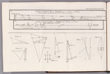
Profil de la Prémiere Base à Yarouqui près de Quito au Perou -- Profil de la Seconde Base à Tarqui près Cuenca au Perou.
List No
14377.016
Note
Two profile views of the first base at Yarouqui near Quito and the second base at Tarqui near Cuenca in Peru. Includes explanatory notes. With figures below illustrating geometry. Black and white engraving. Together, views are 21 x 35 cm, on fold-out sheet 26 x 40 cm. Views appear in third part of volume.
Author
La Condamine, Charles-Marie de, 1701-1774
Full Title
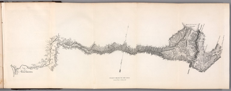
Carte de la meridienne de Quito -- Coupe du Terrein de la Meridienne de Quito suivant sa Longueur : Profil de la Hauteur des Signaux qui ont servi aux Triangles, et des Montagnes les plus remarquables de la Cordeliere des Andes.
List No
14377.017
Note
Two profile views of the meridian of Quito, including certain peaks of the Andes. Shows topography. Relief shown pictorially. Includes explanatory notes. Figures in view above illustrate geometry. Black and white engraving. Together, views are 21 x 46 cm, on fold-out sheet 26 x 51 cm. Views appear in third part of volume.
Author
La Condamine, Charles-Marie de, 1701-1774
Full Title
(Composite text) Table du Calcul des Triangles de la Meridienne de Quito
List No
14377.018
Author
La Condamine, Charles-Marie de, 1701-1774
Full Title
Mesure des trois premiers Degrés du Meridien. R. Brunet scup.
List No
14377.019
Note
Illustration of the measurement of the first three degrees of the meridian of Quito. Shows topography. Includes explanatory notes. View indexed. Black and white engraving. Illustration is 18 x 11 cm, on sheet 26 x 38 cm. Illustration appears in third part of volume.
Author
[Markham, Clements Robert, 1830-1916, Hamilton, Richard Vesey, Royal Geographical Society (Great Britain)]
Full Title
(Covers to) Antarctic exploration : A plea for a national expedition. By Sir C.R. Markham ; with report of the Royal Society's Antarctic Conference ; correspondence with the government ; letter by Admiral Sir R.V. Hamilton, G.C.B. ; and a map. London: The Royal Geographical Society. 1898.
List No
13554.001
Author
[Markham, Clements Robert, 1830-1916, Hamilton, Richard Vesey, Royal Geographical Society (Great Britain)]
Full Title
(Title Page to) Antarctic exploration : A plea for a national expedition. By Sir C.R. Markham ; with report of the Royal Society's Antarctic Conference ; correspondence with the government ; letter by Admiral Sir R.V. Hamilton, G.C.B. ; and a map. London: The Royal Geographical Society. 1898.
List No
13554.002
Author
[Markham, Clements Robert, 1830-1916, Hamilton, Richard Vesey, Royal Geographical Society (Great Britain)]
Full Title
(Composite Text Page to) Antarctic exploration : A plea for a national expedition. By Sir C.R. Markham ; with report of the Royal Society's Antarctic Conference ; correspondence with the government ; letter by Admiral Sir R.V. Hamilton, G.C.B. ; and a map. London: The Royal Geographical Society. 1898.
List No
13554.003
Author
[Markham, Clements Robert, 1830-1916, Hamilton, Richard Vesey, Royal Geographical Society (Great Britain)]
Full Title
Antarctic regions : Maps showing present state of research. By J. G. Bartholomew. F.R.S.E. Royal Geographical Society. The Edinburgh Institute - John Bartholomew & Co. (to accompany) Antarctic exploration : A plea for a national expedition. By Sir C.R. Markham ... London: The Royal Geographical Society. 1898.
List No
13554.004
Note
5 color maps on 1 folded sheet. By John George Bartholomew, F.R.S.E., With inset maps: Victoria Land and of Graham Land. Issued to accompany: Antarctic exploration : A plea for a national expedition. By Sir C.R. Markham. 1898. Maps showing South Pole region “Supposed outline of Continent after Murray”; Mean temperature, February, after Dr. Buchan; Isobars and winds, February, after Dr. Buchan and Sir John Murray; Oceanic deposits, after Dr. J. Murray; and Ocean Currents. Relief shown by hachures, contours and gradient tints. Depths shown by bathymetric tints, isolines and soundings. "The Principal Explorers' Routes within South Polar Regions are marked in Red”. Includes explanation and Sea coloring notes.
Author
[Ulloa, Antonio de, 1716-1795, Juan, Jorge, 1713-1773]
Full Title
(Covers to) Viage a la America Meridion. Tom. I.
List No
14378.001
Note
Covers to the first volume of Relacion historica del viage hecho de orden de S. Mag. a la America Meridional. Bound in leather. Spine has raised bands and gilt floral ornamentation, as well as leather label with gilt title.
Author
[Ulloa, Antonio de, 1716-1795, Juan, Jorge, 1713-1773]
Full Title
(Covers to) Viage a la America Meridion. Tom. I. (Verso)
List No
14378.002
Note
Verso to covers of the first volume of Relacion historica del viage hecho de orden de S. Mag. a la America Meridional. Marbled end papers. With bookplate: Nunc Minerva Postea Palas. Acadæ. Baræ. Valls sculp Bavein.
Author
[Ulloa, Antonio de, 1716-1795, Juan, Jorge, 1713-1773]
Full Title
(Half Title Page to) Relacion historica del viage hecho de orden de S. Mag. a la America Meridional. Primera parte, Tomo primero.
List No
14378.003
Note
Half title page to the first volume of Relacion historica del viage hecho de orden de S. Mag. a la America Meridional. Title translates to: Historical relation of the voyage made by order of S. Mag. to South America.
Author
[Ulloa, Antonio de, 1716-1795, Juan, Jorge, 1713-1773]
Full Title
(Title Page to) Relacion historica del viage a la America Meridional hecho de orden de S. Mag. para medir algunos grados de meridiano terrestre, y venir por ellos en conocimiento de la verdadera Figura, y Magnitud de la Tierra, con otras varias Observaciones Astronomicas, y Phisicas : Por Don Jorge Juan, Comendador de Aliaga, en el Orden de San Juan, Socio correspondiente de la Real Academica de las Ciencias de Paris, y Don Antonio de Ulloa, de la Real Sociedad de Londres : ambos Capitanes de Fragata de la Real Armada. Primera parte, Tomo primero. Impressa de orden del Rey Nuestro Señor en Madrid por Antonio Marin, ano de M. DCC. XLVIII.
List No
14378.004
Note
Title page to the first volume of Relacion historica del viage hecho de orden de S. Mag. a la America Meridional. Title translates (loosely) to: Historical relation of the trip to South America made by order of S. Mag. to measure degrees of the terrestrial meridian, and to come by them in knowledge of the true figure and magnitude of the Earth, with several other astronomical and physical observations. Text printed in red and black. Includes an engraved illustration of figures, horses and a ship.
Author
[Ulloa, Antonio de, 1716-1795, Juan, Jorge, 1713-1773]
Full Title
(Text Page to) Primera parte del viage al Reyno del Perú ... hasta el Reyno de Quito ...
List No
14378.017
Note
Historical text to the first part - in the first volume - of Relacion historica del viage hecho de orden de S. Mag. a la America Meridional. Describes the first part of the voyage to Peru and Quito. With a pictorial view featuring figures, topography, flora and fauna. View indexed, with key below. Black and white engraving. (Page number inferred.)
Author
[Ulloa, Antonio de, 1716-1795, Juan, Jorge, 1713-1773]
Full Title
Isla de La Palma -- Isla Gomera -- Pico de Tenerife -- Isla del Curazao -- Isla de Oruba. Vicente de la Fuente. F. en Madrid.
List No
14378.018
Note
Profile views featuring the topography of the islands La Palma, La Gomera, Tenerife, Curaçao and Aruba. Views show settlements and peaks. Relief shown pictorially. Views include initials designating cardinal directions, as well as explanatory notes. Black and white engraving. Together, views are 21 x 32 cm, on fold-out sheet 27 x 40 cm. Views appear in the first volume of Relacion historica del viage hecho de orden de S. Mag. a la America Meridional.
Author
[Ulloa, Antonio de, 1716-1795, Juan, Jorge, 1713-1773]
Full Title
Cabo de la Vela ... -- Costa cercana a la boca de Río de la Magdalena ... -- Punta de las Avanillas ... -- Punta de Samba ... -- Bugìo del Gato. Moreno sculp. Matti.
List No
14378.019
Note
Profile views featuring the topography of areas including Cabo de la Vela and the Magdalena River. Views show settlements and peaks. Relief shown pictorially. Views include explanatory notes. Indexed to indicate place names. Black and white engraving. Together, views are 21 x 52 cm, on fold-out sheet 27 x 56 cm. Views appear in the first volume of Relacion historica del viage hecho de orden de S. Mag. a la America Meridional.
Author
[Ulloa, Antonio de, 1716-1795, Juan, Jorge, 1713-1773]
Full Title
Assiparece el Pico de Teibes ... -- Assiparece la Isla de La Palma ... -- Esta figura hacela Isla Palma ... -- La Isla de la Gomera en las Canarias ... -- Esta es la figura que representa la Isla del Fierro, en las Canarias ... -- Esta figura hace la Isla de Curazao, una de las Caribes ... Vicente de la Fuente. F. en Madrid.
List No
14378.020
Note
Profile views featuring the topography of areas including La Palma, La Gomera and Curaçao. Views show peaks. Relief shown pictorially. Views include initials designating cardinal directions, as well as explanatory notes. Black and white engraving. Together, views are 21 x 32 cm, on fold-out sheet 27 x 40 cm. Views appear in the first volume of Relacion historica del viage hecho de orden de S. Mag. a la America Meridional.
Author
[Ulloa, Antonio de, 1716-1795, Juan, Jorge, 1713-1773]
Full Title
Plano de la Ciudad de Cartagena de las Indias ... Levantado por orden del Rey Nro. Sr. ano de 1735. Cs. Bargas delt. Cs. Casanova ext.
List No
14378.023
Note
Map featuring Cartagena, Colombia. Shows city blocks, streets, bridges, topography, vegetation, bodies of water, drainage, coastline and islands. Relief shown pictorially. Includes two bar scales and a compass rose with north oriented toward bottom left side of sheet. Indexed to indicate place names. With decorative cartouches. Black and white engraving. Map is 25 x 38 cm, on fold-out sheet 37 x 44 cm. Appears in the first volume of Relacion historica del viage hecho de orden de S. Mag. a la America Meridional.
Author
[Ulloa, Antonio de, 1716-1795, Juan, Jorge, 1713-1773]
Full Title
Plano de la Bahia de Cartagena de la Indias ... Levantado por orden del Rey Nro. Sr. ano de 1735. Cs. Bargas dt. Cva sculpt.
List No
14378.024
Note
Map featuring Cartagena Bay, Colombia. Shows settlements, roads, topography, vegetation, bodies of water, drainage, coastline, islands, shoals and depths. Relief shown pictorially. Includes two bar scales and a compass rose with north oriented toward left side of sheet. With decorative cartouche. Black and white engraving. Map is 26 x 38 cm, on fold-out sheet 37 x 44 cm. Appears in the first volume of Relacion historica del viage hecho de orden de S. Mag. a la America Meridional.
Author
[Ulloa, Antonio de, 1716-1795, Juan, Jorge, 1713-1773]
Full Title
(Text Page to) Libro segundo. Del Viage de Cartagena al Reyno de Tierra-Firme, y Ciudad de Portobelo.
List No
14378.025
Note
Historical text to the second part - in the first volume - of Relacion historica del viage hecho de orden de S. Mag. a la America Meridional. Describes the voyage from Cartagena, Colombia, to the province of Tierra Firme ("mainland province") and the city of Portobelo, Panama. With a pictorial view featuring figures, topography, flora and fauna. View indexed, with key below. Black and white engraving. Text has historiated initial. (Page number inferred.)
Author
[Ulloa, Antonio de, 1716-1795, Juan, Jorge, 1713-1773]
Full Title
Plano de la Bhia y Ciud. de Portovelo ... ano de 1736. Mozeno sculp. Math.
List No
14378.026
Note
Map featuring the city of Portobelo and Portobelo Bay, Panama. Shows city blocks, streets, topography, vegetation, drainage, coastline, islands, shoals and depths. Relief shown pictorially. Includes a bar scale and a compass rose with north oriented toward lower left side of sheet. Indexed to indicate place names. With decorative cartouches. Black and white engraving. Map is 22 x 34 cm, on fold-out sheet 27 x 39 cm. Appears in the first volume of Relacion historica del viage hecho de orden de S. Mag. a la America Meridional.
Author
[Ulloa, Antonio de, 1716-1795, Juan, Jorge, 1713-1773]
Full Title
Dibuso y Demostracion del Octante Ynoles para hacer los Observaciones de los Astros ... Vicente de la Fuente. F. en Madrid.
List No
14378.029
Note
Illustration featuring the English octant, which was used for astronomical observations. Indexed to indicate the instrument's parts. Black and white engraving. Illustration is 21 x 32 cm, on fold-out sheet 27 x 40 cm. Illustration appears in the first volume of Relacion historica del viage hecho de orden de S. Mag. a la America Meridional.
Author
[Ulloa, Antonio de, 1716-1795, Juan, Jorge, 1713-1773]
Full Title
Plano de la Ciudd. de S. Franco. del Quito ... Is. á Palomo sculpr. Regs. Mri. incidit.
List No
14378.033
Note
Map featuring the city of Quito, Ecuador. Shows city blocks, streets, topography, vegetation and drainage. Relief shown pictorially. Includes explanatory notes, as well as a bar scale and compass rose with north oriented toward upper right side of sheet Indexed to indicate place names. With decorative cartouche. Black and white engraving. Map is 31 x 49 cm, on fold-out sheet 40 x 53 cm. Appears in the first volume of Relacion historica del viage hecho de orden de S. Mag. a la America Meridional.
Author
[Ulloa, Antonio de, 1716-1795, Juan, Jorge, 1713-1773]
Full Title
Carta de la Meridiana medida en el Reyno de Quito ... Don Jorge Juan, y Dn. Antonío de Ulloa : concluida año de 1744. Is. á Palomo. sculpr. Regs. Mti. incidit.
List No
14378.045
Note
Map featuring the meridian measured in the Kingdom of Quito by the Order of the King in 1744. Shows settlements, topography, vegetation, drainage and lines of measurement. Relief shown pictorially. Includes a key and bar scale. With decorative cartouche. Black and white engraving. Map is 23 x 101 cm, on fold-out sheet 27 x 126 cm. Appears in the second volume of Relacion historica del viage hecho de orden de S. Mag. a la America Meridional.
Author
[Ulloa, Antonio de, 1716-1795, Juan, Jorge, 1713-1773]
Full Title
Plano scenographico, de la Ciudo. de las Reyes ò Lima Capital de los Reynos del Perú ...
List No
14378.056
Note
Map featuring Lima, Peru. Formatted as a bird's-eye-view. Shows city blocks, streets, bridges, fortification, topography, vegetation and drainage. Relief shown pictorially. Includes two bar scales, as well as an arrow pointing out the water direction in the river. Indexed to indicate place names, with key at upper left and right. With decorative cartouches. Black and white engraving. Map is 38 x 54 cm, on fold-out sheet 42 x 56 cm. Appears in the third volume of Relacion historica del viage hecho de orden de S. Mag. a la America Meridional.
Author
[Ulloa, Antonio de, 1716-1795, Juan, Jorge, 1713-1773]
Full Title
Nueva y correcta carta del Mar Pacifico ó del Sur ... el año de 1744. Fuente F. M.
List No
14378.072
Note
Map featuring the South Pacific Ocean. Shows ports, drainage, coastline, islands, shoals, depths and anchorage. Includes explanatory notes, latitudinal and longitudinal lines, as well as a bar scale and compass rose with north oriented toward left side of sheet. Indexed to indicate place names, with key at bottom right. With decorative cartouches. Black and white engraving. Map is 43 x 71 cm, on fold-out sheet 52 x 79 cm. Appears in the fourth volume of Relacion historica del viage hecho de orden de S. Mag. a la America Meridional.
Author
Fremont John Charles, 1813-1890
Full Title
(Covers to) Report of The Exploring Expedition to The Rocky Mountains in the Year 1842, and to Oregon & North California In The Years 1843-44. By Brevet Capt. J. C. Fremont Of The Corps Of Topographical Engineers Under the orders of Col. J.J. Abert, Chief Of The Topographical Bureau. Printed by order of the Senate of the United States. Washington : Gales and Seaton, Printers. 1845.
List No
13406.001
Note
Bound in original embossed brown cloth, with title in gilt on spine.
Author
Fremont John Charles, 1813-1890
Full Title
(Title Page to) Report of The Exploring Expedition to The Rocky Mountains in the Year 1842, and to Oregon & North California In The Years 1843-44. By Brevet Capt. J. C. Fremont Of The Corps Of Topographical Engineers Under the orders of Col. J.J. Abert, Chief Of The Topographical Bureau. Printed by order of the Senate of the United States. Washington : Gales and Seaton, Printers. 1845.
List No
13406.002
Author
Fremont, J.C.
Full Title
Map Of An Exploring Expedition To The Rocky Mountains in the Year 1842, Oregon & North California In The Years 1843-44. By Brevet Capt. J. C. Fremont Of The Corps Of Topographical Engineers Under the orders of Col. J.J. Abert, Chief Of The Topographical Bureau. Lith. by E. Weber & Co. Baltimore, Md.
List No
10280.000
Note
Senate Issue; map in case. See our 1833.001 for the House issue map which appears to be identical. Text has the astronomical observations that are not in the House issue. The large map of the west is one of the most interesting and beautiful government maps of the 1840's. It filled in many of the gaps in cartographic knowledge of the west. Charles Preuss was the cartographer. Map is without color except for a light blue for water areas.
Author
Fremont John Charles, 1813-1890
Full Title
Chimney Rock. Lith. by E. Weber & Co. Balt. (to accompany) Report of The Exploring Expedition to The Rocky Mountains in the Year 1842, and to Oregon & North California In The Years 1843-44. By Brevet Capt. J. C. Fremont ... Washington : Gales and Seaton, Printers. 1845.
List No
13406.006
Note
Lithograph view, Litho Print by E. Weber & Co.
Author
Fremont John Charles, 1813-1890
Full Title
Fort Laramie. Lith. by E. Weber & Co. Baltimore. (to accompany) Report of The Exploring Expedition to The Rocky Mountains in the Year 1842, and to Oregon & North California In The Years 1843-44. By Brevet Capt. J. C. Fremont ... Washington : Gales and Seaton, Printers. 1845.
List No
13406.007
Note
Lithograph view, Litho Print by E. Weber & Co.
Author
Fremont John Charles, 1813-1890
Full Title
Hot Spring Gate. (to accompany) Report of The Exploring Expedition to The Rocky Mountains in the Year 1842, and to Oregon & North California In The Years 1843-44. By Brevet Capt. J. C. Fremont ... Washington : Gales and Seaton, Printers. 1845.
List No
13406.008
Note
Lithograph view.
Author
Fremont John Charles, 1813-1890
Full Title
Devil's Gate. (to accompany) Report of The Exploring Expedition to The Rocky Mountains in the Year 1842, and to Oregon & North California In The Years 1843-44. By Brevet Capt. J. C. Fremont ... Washington : Gales and Seaton, Printers. 1845.
List No
13406.009
Note
Lithograph view.
Author
Fremont John Charles, 1813-1890
Full Title
View of the Wind River Mountains. Lith. by E. Weber & Co. Baltimore. (to accompany) Report of The Exploring Expedition to The Rocky Mountains in the Year 1842, and to Oregon & North California In The Years 1843-44. By Brevet Capt. J. C. Fremont ... Washington : Gales and Seaton, Printers. 1845.
List No
13406.010
Note
Lithograph view. Published by E. Weber & Co.
Author
Fremont John Charles, 1813-1890
Full Title
Central Chain of the Wind River Mountain. Lith. by E. Weber & Co. Baltimore. (to accompany) Report of The Exploring Expedition to The Rocky Mountains in the Year 1842, and to Oregon & North California In The Years 1843-44. By Brevet Capt. J. C. Fremont ... Washington : Gales and Seaton, Printers. 1845.
List No
13406.011
Note
Lithograph view. Published by E. Weber & Co.
Author
Fremont John Charles, 1813-1890
Full Title
View of Pik's Peak, 40 miles distant from camp, July 11th. Lith. by E. Weber & Co. Baltimore. (to accompany) Report of The Exploring Expedition to The Rocky Mountains in the Year 1842, and to Oregon & North California In The Years 1843-44. By Brevet Capt. J. C. Fremont ... Washington : Gales and Seaton, Printers. 1845.
List No
13406.012
Note
Lithograph view. Published by E. Weber & Co.
Author
Fremont John Charles, 1813-1890
Full Title
(Emigrant route in Bear River Valley). Lith. by E. Weber & Co. Baltimore. (to accompany) Report of The Exploring Expedition to The Rocky Mountains in the Year 1842, and to Oregon & North California In The Years 1843-44. By Brevet Capt. J. C. Fremont ... Washington : Gales and Seaton, Printers. 1845.
List No
13406.013
Note
Untitled folded map of emigrant route in Bear River Valley. Relief shown by hachures. Oriented with the north to upper right.
Author
Fremont John Charles, 1813-1890
Full Title
Bear Spring. Lith. by E. Weber & Co. (to accompany) Report of The Exploring Expedition to The Rocky Mountains in the Year 1842, and to Oregon & North California In The Years 1843-44. By Brevet Capt. J. C. Fremont ... Washington : Gales and Seaton, Printers. 1845.
List No
13406.014
Note
Lithograph map. Relief shown by hachures. Oriented with the north to lower right.
Author
Fremont John Charles, 1813-1890
Full Title
Pass of the Standing Rock. Lith. by E. Weber & Co. (to accompany) Report of The Exploring Expedition to The Rocky Mountains in the Year 1842, and to Oregon & North California In The Years 1843-44. By Brevet Capt. J. C. Fremont ... Washington : Gales and Seaton, Printers. 1845.
List No
13406.015
Note
Lithograph view. Published by E. Weber & Co. Relief shown by hachures.
Author
Fremont John Charles, 1813-1890
Full Title
The Great Salt Lake. Lith. by E. Weber & Co. (to accompany) Report of The Exploring Expedition to The Rocky Mountains in the Year 1842, and to Oregon & North California In The Years 1843-44. By Brevet Capt. J. C. Fremont ... Washington : Gales and Seaton, Printers. 1845.
List No
13406.016
Note
Lithograph map. Published by E. Weber & Co. . Relief shown by hachures.
Author
Fremont John Charles, 1813-1890
Full Title
The American Falls of Lewis Fork. (to accompany) Report of The Exploring Expedition to The Rocky Mountains in the Year 1842, and to Oregon & North California In The Years 1843-44. By Brevet Capt. J. C. Fremont ... Washington : Gales and Seaton, Printers. 1845.
List No
13406.017
Note
Lithograph map. Published by E. Weber & Co.
Author
Fremont John Charles, 1813-1890
Full Title
Outlet of Subterranian River. Lith. by E. Weber & Co. Baltimore. (to accompany) Report of The Exploring Expedition to The Rocky Mountains in the Year 1842, and to Oregon & North California In The Years 1843-44. By Brevet Capt. J. C. Fremont ... Washington : Gales and Seaton, Printers. 1845.
List No
13406.018
Note
Lithograph map. Published by E. Weber & Co.
Author
Fremont John Charles, 1813-1890
Full Title
Hill of Columnar Basalt on the Columbia River. Lith. by E. Weber & Co. Baltimore. (to accompany) Report of The Exploring Expedition to The Rocky Mountains in the Year 1842, and to Oregon & North California In The Years 1843-44. By Brevet Capt. J. C. Fremont ... Washington : Gales and Seaton, Printers. 1845.
List No
13406.019
Note
Lithograph map. Published by E. Weber & Co.
Author
Fremont John Charles, 1813-1890
Full Title
The Pyramid Lake. Lith. by E. Weber & Co. Baltimore. (to accompany) Report of The Exploring Expedition to The Rocky Mountains in the Year 1842, and to Oregon & North California In The Years 1843-44. By Brevet Capt. J. C. Fremont ... Washington : Gales and Seaton, Printers. 1845.
List No
13406.020
Note
Lithograph map. Published by E. Weber & Co.
Author
Fremont John Charles, 1813-1890
Full Title
Pass in the Sierra Nevada of California. Lith. by E. Weber & Co. Baltimore. (to accompany) Report of The Exploring Expedition to The Rocky Mountains in the Year 1842, and to Oregon & North California In The Years 1843-44. By Brevet Capt. J. C. Fremont ... Washington : Gales and Seaton, Printers. 1845.
List No
13406.021
Note
Lithograph map. Published by E. Weber & Co.
Author
Fremont John Charles, 1813-1890
Full Title
(Map of the crossing of the Sierra Nevada by the South Fork of the American River). Lith. by E. Weber & Co. Baltimore. (to accompany) Report of The Exploring Expedition to The Rocky Mountains in the Year 1842, and to Oregon & North California In The Years 1843-44. By Brevet Capt. J. C. Fremont ... Washington : Gales and Seaton, Printers. 1845.
List No
13406.022
Note
Untitled folding map of the crossing of the Sierra Nevada. Published by E. Weber & Co.
Author
Fremont John Charles, 1813-1890
Full Title
Fossil fresh water infusoria from Oregon. J. W. Bailey del. Lith. by E. Weber & Co. Baltimore. (to accompany) Report of The Exploring Expedition to The Rocky Mountains in the Year 1842, and to Oregon & North California In The Years 1843-44. By Brevet Capt. J. C. Fremont ... Washington : Gales and Seaton, Printers. 1845.
List No
13406.023
Note
24 lithograph views of fossil shells. Published by E. Weber & Co. In upper right margin: PL. V.
Author
Fremont John Charles, 1813-1890
Full Title
Fossil Ferns : Collection of the Geographical Survey of Oregon and North California. Lith. by E. Weber & Co. Baltimore. (to accompany) Report of The Exploring Expedition to The Rocky Mountains in the Year 1842, and to Oregon & North California In The Years 1843-44. By Brevet Capt. J. C. Fremont ... Washington : Gales and Seaton, Printers. 1845.
List No
13406.024
Note
8 lithograph views of fossil Ferns in 11 parts. Published by E. Weber & Co. In upper right margin: PL. I.
Author
Fremont John Charles, 1813-1890
Full Title
Fossil Ferns : Collection of the Geographical Survey of Oregon and North California. Lith. by E. Weber & Co. Baltimore. (to accompany) Report of The Exploring Expedition to The Rocky Mountains in the Year 1842, and to Oregon & North California In The Years 1843-44. By Brevet Capt. J. C. Fremont ... Washington : Gales and Seaton, Printers. 1845.
List No
13406.025
Note
5 lithograph views of fossil Ferns in 15 parts. Published by E. Weber & Co. In upper right margin: PL. II.
Author
Fremont John Charles, 1813-1890
Full Title
Fossil Ferns : Collection of the Geographical Survey of Oregon and North California. Lith. by E. Weber & Co. Baltimore. (to accompany) Report of The Exploring Expedition to The Rocky Mountains in the Year 1842, and to Oregon & North California In The Years 1843-44. By Brevet Capt. J. C. Fremont ... Washington : Gales and Seaton, Printers. 1845.
List No
13406.026
Note
14 lithograph views of fossil Ferns in 20 parts. Published by E. Weber & Co. In upper right margin: PL. III.
Author
Fremont John Charles, 1813-1890
Full Title
Fossil Shells : Collection of the Geographical Survey of Oregon and North California. Lith. by E. Weber & Co. Baltimore. (to accompany) Report of The Exploring Expedition to The Rocky Mountains in the Year 1842, and to Oregon & North California In The Years 1843-44. By Brevet Capt. J. C. Fremont ... Washington : Gales and Seaton, Printers. 1845.
List No
13406.027
Note
3 lithograph view. Published by E. Weber & Co. In upper right margin: Botany Plate IV.
Author
Fremont John Charles, 1813-1890
Full Title
Ardomecon Californicum. Lith. by E. Weber & Co. Baltimore. (to accompany) Report of The Exploring Expedition to The Rocky Mountains in the Year 1842, and to Oregon & North California In The Years 1843-44. By Brevet Capt. J. C. Fremont ... Washington : Gales and Seaton, Printers. 1845.
List No
13406.028
Note
Lithograph view. Published by E. Weber & Co. In upper right margin: Botany Plate II.
Author
Fremont John Charles, 1813-1890
Full Title
Prosopis odorata. Lith. by E. Weber & Co. Baltimore. (to accompany) Report of The Exploring Expedition to The Rocky Mountains in the Year 1842, and to Oregon & North California In The Years 1843-44. By Brevet Capt. J. C. Fremont ... Washington : Gales and Seaton, Printers. 1845.
List No
13406.029
Note
Lithograph view. Published by E. Weber & Co. In upper right margin: Botany Plate I.
|


![Covers: [Nieuwe werelt anders ghenaempt West-Indien.]](https://www.davidrumsey.com/rumsey/Size2/RUMSEY~8~1/205/14476001.jpg)


![[Jacobus Lemarius].](https://www.davidrumsey.com/rumsey/Size1/RUMSEY~8~1/205/14476022.jpg)
![[Patagones]. 1615 Decēb. Numero 1.](https://www.davidrumsey.com/rumsey/Size1/RUMSEY~8~1/205/14476023.jpg)
![[Tierra del Fuogo].](https://www.davidrumsey.com/rumsey/Size2/RUMSEY~8~1/205/14476024.jpg)


![[Pacific Ocean].](https://www.davidrumsey.com/rumsey/Size2/RUMSEY~8~1/205/14476029.jpg)