|
REFINE
Browse All : Covers of Maryland
1-15 of 15
Author
Bachmann, John
Full Title
(Covers to) Panorama of the Seat of War. Birds Eye View Of Virginia, Maryland Delaware And The District Of Columbia. John Bachmann, Publisher, 115 & 117 Nassau St., New York. Entered ... 1861 by John Bachmann ... New York. Drawn from Nature and Lith. by John Bachmann.
List No
0043A
Author
Cram, George Franklin
Full Title
(Covers to) Cram's Railroad & County Map Of Virginia, W. Virginia, Maryland & Delaware. Published By Geo. F. Cram. Proprietor Of The Western Map Depot. 262-264 Wabash, Ave. Chicago, Ills. 1881. Entered ... 1878, by G.F. Cram... Washington D.C.
List No
0209.001
Note
From the New Commercial Atlas of the U.S. 1875. Folded into brown cloth covers 14x9 with "Indexed Railroad And County Map Virginia W. Va. Md. & Delaware Published By Geo. F. Cram. Chicago" in gilt. Full color. Relief shown by hachures.
Author
[Yardley, Richard Q., Oriole Cafeterias, Inc.]
Full Title
(Covers to) Oriole map of Baltimore. Complements of the Oriole Cafeterias. Yardley.
List No
11697.001
Note
Colorful promotional pictorial map of Baltimore, on sheet 45x41, folded to self wrapped cover 23x10. Published in 1947, created by Richard Q. Yardley, an editorial cartoonist for the Baltimore Sun newspaper. Produced to advertise the city's three Oriole Cafeterias. Text on verso of map focuses on Baltimore's history, the city's cultural and business attributes, plus details of the city's three Oriole Cafeterias ("Good Food is Good Health"). The map centers on the towering Washington Monument on Charles Street, completed in 1829. In the immediate vicinity are the Peabody Institute and the Walters Art Museum. Streets, and illustrations of numerous Baltimore landmarks, including the locations of the three Oriole Cafeterias, as well as historical events and places of interest depicted on the map.
Author
Colton, G.W. & C.B.
Full Title
(Covers to) Colton's Delaware And Maryland. Published By G.W. And C.B. Colton & Co. No. 172 William St. New York. 1873. Entered ... 1855 by J.H. Colton & Co ... New York. (inset) District Of Columbia.
List No
1701.001
Note
From the Colton General Atlas map of the same title. Full color by county, folded into brown cloth covers 12.5x8.5 with "Colton's Map Of Maryland And Delaware G.W. & C.B. Colton & Co" in gilt. Prime meridians are Greenwich and Washington D.C. Relief shown by hachures.
Author
Monk, Jacob
Full Title
(Covers to) Map Of The Seat Of War Exhibiting The Surrounding Country, The Approaches By Sea & Land To The Capital Of The United States And The Military Posts, Forts, &c. Published by Jacob Monk, Philadelphia. 1861. T. Sinclair's Lith, Phila.
List No
2031A
Author
Colton, J.H.
Full Title
(Covers to) J.H. Colton's Topographical Map of Seat Of War In Virginia, Maryland, &c. J.H. Colton's Geographical Establishment No. 172 William St. New York. Entered.. 1855, by J.H. Colton & Co ... New York. Printed By Cooper, 117 Fulton St. N.Y.
List No
2045.001
Note
Early map of battle area, copyright 1855. Stephenson is probably wrong in dating this as 1863. We date it as 1861 because it is earlier than the copy we have that is entered in 1862 (which copy Stephenson misdates as entered in 1852). Folded into dark green textured cloth covers 14.5x9.5 with the title "Map Of The Seat Of War In Virginia, Maryland, &c. J.H. Colton." in gilt. Prime meridian is Washington D.C.
Author
Lucas, Fielding Jr.
Full Title
(Covers to) The Tourist's Guide Through the States of Maryland, Delaware, and Parts Of Pennsylvania & Virginia, With The Route To Their Springs, &cc. Drawn and Published by F. Lucas Jr. Baltimore. Entered ... 1836, by F. Lucas Jr. ... Maryland. Engraved by J. Yeager Philadelphia.
List No
2230.001
Note
Later than the Maryland map in General Atlas. Pierce Butler signed inside cover; father of Fanny(?) Brice. Full color by county, folded into red leather covers 13x8 with "Map Of Maryland And Part Of Virginia &cc." stamped in gilt. Prime meridian is Washington D.C.
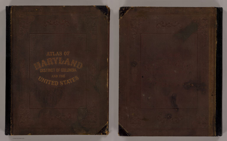
Gray, Ormando Willis; Lloyd, H.H.; Marte... Cover: Atlas, Maryland, District of Colu... 1873 2239A Related Author
[Gray, Ormando Willis, Lloyd, H.H., Martenet, Simon J., Walling, H. F.]
Full Title
(Covers to) New topographical atlas of the State of Maryland and the District of Columbia. With descriptions historical, scientific, and statistical, together with maps of the United States and Territories. By S.J. Martenet, H.F. Walling, and O.W. Gray, civil and topographical engineers. Published by Stedman, Brown & Lyon, Baltimore. 1873. (on verso ot title page) Entered ... 1872, by H.F. Walling, and O.W. Gray, and Simon J. Martenet ... Washington.
List No
2239A
Note
With maps of U.S. by H.H. Lloyd (no imprint). These Lloyd maps are in a different configuration than the Lloyd maps(from the same base) used in Warner, Higgins & Beers "Atlas of Illinois," 1871. Full color maps. Covers are half leather brown cloth covered boards with "Atlas of Maryland, District of Columbia and the United States" stamped in gilt.
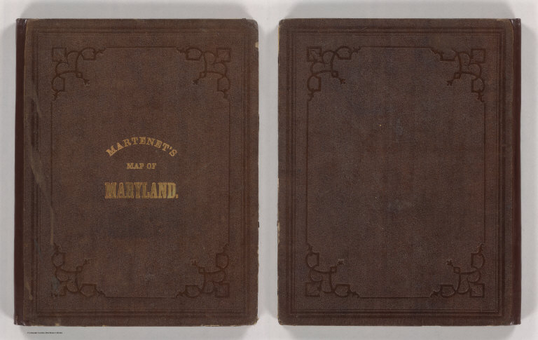
Author
Martenet, Simon J.
Full Title
(Covers to) Martenet's Map of Maryland, Atlas Edition, Under the Patronage of the Legislature.
List No
2517A
Note
Embossed front and back brown cloth binding, little wear. Front cover title stamped in gold: "Martenet's Map of Maryland."
Author
Colton, J.H.
Full Title
(Covers to) J.H. Colton's Topographical Map of the Seat Of War In Virginia, Maryland, &c. J.H. Colton's Geographical Establishment No. 172 William St. New York. Entered ... 1862, by J.H. Colton ... New York. Printed By Lang & Cooper, 117 Fulton St. N.Y.
List No
2855.001
Note
Entered in 1862. The map details are the same as the (1861) edition except for the copyright date. Stephenson incorrectly reads the copyright as 1852 - it is 1862. Backed on linen and dissected. Folded into black textured cloth covers 15x9.5 with "Map Of The Seat Of War In Virginia, Maryland, &c. J.H. Colton." in gilt. Prime meridian is Washington D.C. Relief shown by hachures.
Author
Rand McNally and Company
Full Title
(Covers to) Rand McNally Special Auto Road Map Delaware, Maryland, Virginia, West Virginia. Copyright By Rand McNally & Company, Chicago, Ill. Made In U.S.A. ...
List No
3296.001
Note
Shows early Highway symbols and Trail Markings. In dark blue print without color. Folded into gray card board covers 16x11 printed with "Del. - Md. - Va. - W. Va. Liberty Auto Road Map 1926. Price 10 Cents. 5 (cents) Liberty, A Weekly for the Whole Family. Auto Dept. 247 Park Avenue, New York, N.Y." On the back cover it reads "This map is issued by Liberty as a special service to its readers..."
Author
Colton, G.W. & C.B.
Full Title
(Covers to) Colton's Railroad & Commercial Atlas Of The United States, Canada Etc. Map No. 6. Delaware, Maryland, Virginia, West Virginia, N. Carolina, Kentucky & Tennessee. Published by G.W. And C.B. Colton, & Co. 172 William St. New York. 1870. Entered ... 1866, by G.W. & C.B. Colton & Co ... N.Y.
List No
3940.001
Note
One of a series of regional pocket railroad maps that comprised Colton's "Railroad & Commercial Atlas Of The United States..." (see our #160). Full color by county, folded into dark brown cloth covers 15.5x10 with "G. Woolworth Colton's County & Distance Railroad Map of Virginia, West Va., N. Car., Kentucky & Tennessee. Showing every Station &c" in gilt.
Author
Colton, J. H.
Full Title
(Covers to) Colton's New Topographical Map of The States Of Virginia, Maryland and Delaware, Showing Also Eastern Tennessee & Parts Of Other Adjoining States, All the Fortifications, Military Stations, Rail Roads, Common Roads and other Internal Improvements Compiled from the Latest & most Authentic Sources, On A Scale of 12 Miles to the Inch. Published By J.H. Colton, No. 172 William St. New York. Entered ... 1862, by J.H. Colton ... New York. Printed by Lang & Laing Lith 117 Fulton St. New York.
List No
4856A
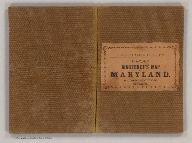
Author
Martenet, Simon J.
Full Title
(Covers to) City of Baltimore. (Baltimore, Simon J. Martenet, 1866)
List No
4920A
Note
Textured brown cloth covers 13x8.5 with "Baltimore City, From Martenet's Map Of Maryland, Atlas Edition. Copy-righted." printed in black on beige paste down label.
Author
MacCormac, Walter S.
Full Title
(Covers to) Map Of The Peninsula, Embracing Delaware And The Eastern Shore Of Maryland And Virginia, Compiled from U.S. Coast, and other Actual Surveys, and recent information obtained from various sources. By Walter S. MacCormac, Civ. Eng. Published by Smith & Stroup, Nos. 52 & 54 North Sixth Street, Philadelphia. 1879. Entered ... 1878, by E.W Smith ... Washington.
List No
4960.001
Note
Attractive, large scale map showing the entire Delaware Peninsula, Chesapeake Bay, eastern Virginia and Maryland and southern New Jersey. The Peninsula is shown in great detail with the surrounding areas in more schematic form. An unusual presentation. This large two sheet pocket map is not in any references - Phillips lists an 1868 map of similar title and size by Boughman, Thomas & Co. with D.G. Beers as the compiler. This 1879 map is copyright 1878 by E.W. Smith. Both map halves are folded into dark brown cloth covers 15.5x10 with the title "New Map Of The Peninsula Embracing Delaware And The Eastern Shores Of Maryland And Virginia. Smith & Stroup." stamped in gilt. Full color by county.
1-15 of 15
|