|
REFINE
Browse All : Covers from 1882
1-37 of 37
Author
Yamamura, Seisuke
Full Title
東京繪圖. [Tokyo ezu].
List No
15098.001
Author
[Stolpe, C., Straube, Julius]
Full Title
(Covers to) Plan von Constantinopel mit den Vorstädten, dem Hafen, und einem Theile des Bosporus = Plan de Constantinople avec ses faubourgs, le port et une partie du Bosphore
List No
10679.001
Author
Garnier frères
Full Title
(Covers to) Nouveau Paris monumental. Itinéraire pratique de l'étranger dans Paris.
List No
10187.002
Note
Show important buildings and monuments of Paris in isometric view.
Author
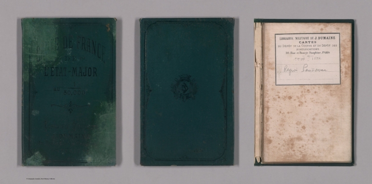
[France. Service géographique de l'armée, Depot De La Guerre (France)]
Full Title
(Covers to) Paris. 48. (Carte de France Etat Major 80,000). Levée par les officiers du Corps d'Etat-Major et publiée par le Dépôt général de la guerre en 1832.
List No
10191.001
Note
Date estimated based on railroad construction. This is sheet 48 of the 258 sheet Carte de France de l'Etat-Major, completed in 1832 as a replacement for the 182 sheet Cassini Survey. All sheets were updated through the early 20th century. Folded into green covers with attached map of France showing the assembly of all 258 sheets.
Author
[Ministere des Travaux Publics, Cheysson, Émile]
Full Title
(Covers to) Direction des Cartes, Plans et Archives, et de la Statistique Graphique. 1882. Paris. Imprimerie Nationale. 1882.
List No
12513.001
Note
Pale green paper-covered boards. Title page text in black on front cover. Text in black on spine, "Album de Statistique Graphique - 1882".
Author
Stanford, Edward, 1827-1904
Full Title
(Covers to) Stanford's London atlas of universal geography : Quarto edition.
List No
14081.001
Note
Covers to Stanford's London atlas of universal geography : Quarto edition. Bound in leather-covered board, with title on front cover in gilt. Spine title, in gilt: London atlas of universal geography. Page edges in gilt.
Author
Cram, George Franklin, 1841-1928
Full Title
(Covers to) Cram's indexed commercial atlas of the western and southern states. 1882.
List No
14250.001
Note
Covers to Cram's New indexed commercial atlas of the western and southern states. Bound in board with gilded title and date; and with marbled page edges. Includes ornamental border.
Author
Becker, George F.
Full Title
(Covers to) Department Of The Interior, United States Geological Survey, Clarence King Director. Atlas To Accompany The Monograph On The Geology Of The Comstock Lode And The Washoe District By George F. Becker. Washington 1882. Julius Bien & Co. Lith. New York.
List No
1566A
Author
Beers, J.H. & Co.
Full Title
(Covers to) Atlas of Franklin Co. Indiana. To Which Are Added Various General Maps History, Statistics, Illustrations. &c. &c. &c. J.H. Beers & Co. Publishers, Lakeside Building Cor. of Clark & Adams Sts. Chicago. 1882.
List No
1576.001
Note
Very dark brown cloth covered boards with very pale spine label reading, "Franklin County."
Author
Blackie, W.G.
Full Title
(Covers to) The Comprehensive Atlas & Geography Of The World: Comprising An Extensive Series Of Maps, A Description, Physical And Political, Of All The Countries Of The Earth; A Pronouncing Vocabulary Of Geographical Names, And A Copious Index Of Geographical Positions ... Compiled And Engraved From The Most Authentic Sources, Under The Supervision Of W.G. Blackie Ph.D., F.S.A. Scot. ... B. & S. Lucem Libris Disseminamus. London: Blackie & Son, 49 & 50 Old Bailey, E.C.; Glasgow, Edinburgh, And Dublin. 1882. (on verso) Glasgow: W.G. Blackie And Co., Printers, Villafield.
List No
1589.001
Note
Covers are half leather brown marbled cloth covered boards with "The Comprehensive Atlas And Geography Of The World." stamped in gilt on the front and spine.
Author
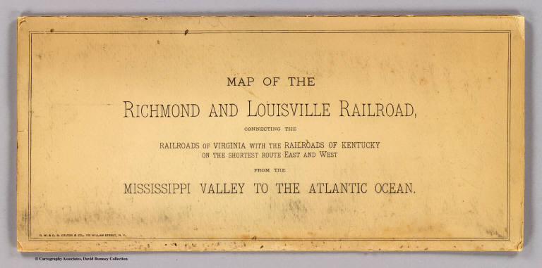
G.W. & C.B. Colton & Co.
Full Title
(Covers to) Map of the Richmond and Louisville R.R. connecting the railroads of Virginia with the railroads of Kentucky on the shortest route east and west from the Mississippi Valley to the Atlantic Ocean. Engraved, printed and manufactured by G.W. & C.B. Colton & Co. No. 182 William St. New York. Entered ... 1882 by G.W. & C.B. Colton & Co. ... at Washington.
List No
1702A
Note
Heavy beige paper covers printed with the title: Map of the Richmond and Louisville Railroad, connecting the railroads of Virginia with the railroads of Kentucky on the shortest route east and west from the Mississippi Valley to the Atlantic Ocean.
Author
Dutton, Clarence E. (Clarence Edward), 1841-1912
Full Title
(Covers to) Tertiary History of the Grand Canon District With Atlas by Clarence E. Dutton, Captain of Ordnance U.S.A. United States Geological Survey, J.W. Powell, Director. Washington: Government Printing Office 1882. Department of the Interior. Monographs of the United States Geological Survey, Volume II. Washington: Government Printing Office 1882.
List No
2147.001
Note
Bound in brown linen covered boards with "U.S. Geological Survey, J.W. Powell, Director. Monographs II, Dutton. Tertiary History of the Grand Canon District" on the spine in gold.
Author
Smith, J.L.
Full Title
(Covers to) Driving Map of Philadelphia and Vicinity. Published by J.L. Smith, 27 South Sixth St. Phila., Pa. 1882. Entered ... 1882 by J.L. Smith ... Washington.
List No
2459.001
Note
J.L. Smith succeeded to R.L. Barnes' map business. J.L. Smith was a map publisher in Philadelphia in the 1870-1890 period. He is not listed in Ristow, other than as a publisher of Martinet's Maryland map in its later editions. Folded into brown cloth covers 15.5x10.5 with "Smith's Map of Philadelphia And Vicinity" stamped in gilt.
Author
Colton, G.W. & C.B.
Full Title
(Covers to) Map Of The Country Thirty Three Miles Around The City Of New York. Published By G.W. And C.B. Colton, & Co., 182 William St. New York. Entered ... 1846, by J.H. Colton ... New York. 1882.
List No
2476.001
Note
Still more railroads are added, compared to the 1876 edition. An unknown "L.A. Roberts" is listed as the Colton's partner on the inside cover paste down ad. Folded into dark brown cloth covers 14.5x9 with "Colton's Map Of The Country Thirty Three Miles Around The City Of New-York G.W. & C.B. Colton & Co" in gilt. Full color. Prime meridians are Greenwich and Washington D.C. Relief shown by hachures, depth shown by isolines and soundings.
Author
Rand McNally and Company
Full Title
(Covers to) Rand, McNally & Co's. general map of the Republic of Mexico constructed from the best authorities showing completed & proposed railways, steamship routes and telegraphic communications. Chicago, U.S. 1882. Rand, McNally & Co., Map Publisher and Engravers, Chicago, Ill. Copyrighted, 1882 by Rand, McNally & Co., Chicago, Ill.
List No
3347A
Note
Very large hand colored map with detailed engraving. This does not look like the "normal" Rand McNally map - it is probably a separately made map that they acquired the rights to. This copy was sold in England by Edward Stanford and has his label on the case. Map is in four sheets, each dissected into 21 sections. With outline color by state, topography shown in brown, and railways and shipping routes in red. Sheets have marbled end papers with labels reading "North East", "North West", "South East" and "South West"; all fold into a brown cloth slip case 22.5x14.5 with a label reading "Mexico. London: Edward Stanford, Wholesale & Retail Mapseller, &c. 55, Charing Cross. Agent by Appointment ..." Relief shown by shading. Prime meridians: Washington and Greenwich.
Author
Rice, G. Jay.
Full Title
(Covers to) Rice's New Sectional Map of the State of Minnesota. 1882. Published By St. Paul Lithographing & Publishing Co. St. Paul, Minn. Oct. Edition 1882. Copyright 1880 by G. Jay Rice. (inset) Map Of St. Paul, Minneapolis & Vicinity.
List No
3416.001
Note
1st edition 1880. "Oct. edition 1882" below the title. The state is still undeveloped in the north. See Rice's Dakota maps. Full color by county and folded into brown cloth covers 14.5x9.5 stamped with "Rice's Sectional Map Of Minnesota" in gilt.
Author
Faust, H.W.
Full Title
(Covers to) Faust's Map & Guide Of San Francisco. Published by H.W. Faust. Entered by H.W. Faust ... Washington, D.C., June 1882. Galloway Litho. Co., 422 Commercial St., S.F. Compiled By P. Spitze. C.E. (inset) Map Of The City & County Of San Francisco. (inset) General View Of San Francisco Bay.
List No
3640.001
Note
The map is smaller than the later editions, covering only the area of the city west to 7th Avenue. Has a 64 page printed guide to San Francisco. Map is folded into tan card board covers 17.5x10 with "Faust's Map And Guide Of San Francisco. Together With General Information, Pertaining To ... and a Beautiful Colored Litograph Map Of The City ... Price Paper Cover, 25 Cts. Cloth Cover, 50 Cts. Trade Supplied By The San Francisco News Company. Henry W. Faust, Publisher and Prop'r. S.F. Cal. Eighth Edition."
Author
Page, H.R. & Co.
Full Title
(Covers to) Map Of Michigan Compiled from the latest Authentic Sources. Published by H.R. Page & Co. Chicago, Ill. 1882. (with 2 inset maps).
List No
4053.001
Note
Karrow shows editions of 1879, 1880, and 1884, but not this 1882 edition. Large map of the state with inset maps of Isle Royale and the western upper peninsula. With Index "Guide to Michigan". Publisher's advertisement on inside front cover. Folded into textured dark brown cloth covers 15x10 with "Sectional Michigan H.R. Page & Co. Chicago" in gilt.
Author
Thayer, H.L.
Full Title
(Covers to) Thayer's Map Of New Mexico. Published By H.L. Thayer, Denver, Col. From Surveys of the General Land Office, used by permission, revised & corrected to date by the Publisher. Photo lith & print by Julius Bien & Co. 16 & 18 Park Place N.Y.
List No
4335.001
Note
This is from the same plate used by Bien for the General Land Office "Map of The Territory of New Mexico" first issued in 1879. Comparing this with the 1882 GLO edition we can find absolutely no changes, notwithstanding Thayer's claims in the title. The only difference is the use of hand color by Thayer versus printed color by the GLO. Undated, with the date estimated by comparison with the GLO map of 1882. The Streeter copy is dated 1880. Scarce. Map is folded into dark green cloth covers 15x10 with "Thayer's Map Of New Mexico. One Dollar." stamped in gilt.
Author
[Page, H.R. & Co., Brewster, Charles]
Full Title
(Covers to) Map of Nebraska. Compiled from Official Records in the Surveyor General's Office And Other Authentic Sources By Charles Brewster C.E. Published by H.R. Page & Co. Chicago, Ill. 1882. Copyright 1879 by H.R. Page & Co.
List No
4421.001
Note
First edition was 1879. Large impressive sectional map of the State in two separate sheets. Two huge counties, Sioux and Cheyenne, cover the westernmost portion of the state at the Wyoming border. Another unnamed county dominates the upper middle section. The sectional surveys are completed throughout, except for the northwest corner. There was an earlier edition in 1880. Full color. Folded in textured black cloth covers 17x11 with "Sectional Map Of Nebraska H.R. Page & Co. Chicago." stamped in gold.
Author
Rand McNally and Company
Full Title
(Covers to) Rand McNally & Co.'s Dakota. Copyright, 1882, by Rand, McNally & Co., Map Publishers, Chicago, Ill. Rand, McNally & Co., Engr's. Chicago. (with 15 page index) Rand McNally & Co.'s Indexed County And Township Map Of Dakota... Chicago, U.S.A.: Rand, McNally & Co. ... (on verso) Entered ... 1882, by Rand, McNally & Co. ... Washington.
List No
4502.001
Note
A large and very early Rand McNally map of Dakota that does not appear in the Indexed Atlas of 1881 or 1882. Another version was published for the Chicago, Milwaukee & St. Paul Railway Co. in 1882 (see our copy). Folded into tan card board covers 17x11 printed with same title as index. Prime meridians are Greenwich and Washington D.C. Relief shown by hachures.
Author
Cram, George Franklin
Full Title
(Covers to) Cram's Unrivaled Family Atlas of the World.
List No
4558.001
Note
Bound in light brown cloth covered boards with decorative stamping and stamped text in light gold, "Cram's Unrivaled Family Atlas of the World". Blind stamped on back cover.
Author
Dutton, Clarence E. (Clarence Edward), 1841-1912
Full Title
(Covers to) Department Of The Interior, United States Geological Survey, J.W. Powell Director. Atlas To Accompany The Monograph On The Tertiary History Of The Grand Canon District By Capt. Clarence E. Dutton U.S.A. Washington 1882. Julius Bien & Co. Lith. New York.
List No
4713A
Author
Rand McNally and Company
Full Title
(Covers to) Rand McNally & Co.'s New Enlarged Scale Railroad And County Map Of Texas, Showing Every Railroad Station And Post Office In The State. Copyright, 1882, By Rand, McNally & Co., Chicago, Ill. (inset) N.W. Corner & Pan-Handle. (untitled inset map of El Paso). (with 49 page index) Rand, McNally & Co.'s Indexed County And Township Map Of Texas ... Chicago, U.S.A.: Rand, McNally & Co., Map Publishers and Engravers. (on verso) Entered ... 1882, by Rand, McNally & Co. ... Washington.
List No
4749A
Author
Edwards, John P.
Full Title
(Covers to) Historical Atlas Of Sedgwick County Kansas. Compiled Drawn & Published From Personal Examinations And Surveys By John P. Edwards, No. 31 South 6th Street. Philadelphia, 1882. Branch Office Wichita, Kansas. Engraved by Win. Bracher, 27 So. 6th St. Philada. Printed by F. Bourquin, 31 Sth. 6th St. Philada.
List No
4836.001
Note
Bound in half leather dark brown cloth covered boards with "Edwards' Historical Atlas Of Sedgwick Co. Kansas 1882" stamped in gilt.
Author
[Kerr, W.C., Guyot, Arnold]
Full Title
(Covers to) Map Of North Carolina, By W.C. Kerr, State Geologist; Assisted by Capt. Wm. Cain, C.E. Published Under The Authority Of The State Board Of Agriculture. 1882. Constructed From Original Surveys And Triangulations Of The U.S. Coast And Geodetic Survey, Of Prof. Guyot, Of The State Geologist, And Of the U.S. Engineers; And Embodying The Surveys Made By The State From 1820 To Date ... Julius Bien & Co. Lith. N.Y. Entered ... 1882, by W.C. Kerr ... Washington.
List No
4854.001
Note
This is a large scale map of the state, beautifully executed with the mountains in printed color and the counties hand colored. It was probably backed financially by the state and is inscribed to Governor Thomas J. Jarvis. Below the title is the following: "The Map of a large part of the Mountain region was plotted to scale, from his own Triangulations, and furnished to hand, by Prof. Guyot, of Princeton." With a listing of Railroads, Towns with populations over 500, and Notes on state statistics. Folded into brown cloth covers 18.5x11 with "State Map Of North Carolina." in gilt.
Author
Cram, George Franklin
Full Title
(Covers to) Pennsylvania. Geo. F. Cram, Engraver and Publisher, Chicago. Copyrighted 1882.
List No
4900.001
Note
With 85 page Index to Cram's Map of Pennsylvania, including a separate index of 67 railroads. This map predates, but is in the same form as, the Standard American Atlas maps of 1887 (our earliest issue). The Pennsylvania map in that atlas lists 76 railroads. Folded into black cloth covers 15x10 with "Indexed Railroad And County Map Of Pennsylvania Published By Geo. F. Cram Chicago" in gilt, which is worn off on this copy. Printed color. Prime meridians are Greenwich and Washington D.C.
Author
[Thayer, H. L., U.S. General Land Office]
Full Title
(Covers to) Thayer's map of Colorado. Published by H.L. Thayer, Denver, Col. 1882. Note. From surveys of the General Land Office, used by permission, revised & corrected to date by the publisher. Photo lith. & print. by Julius Bien & Co., 16 & 18 Park Place, N.Y.
List No
5203A
Note
Embossed brown cloth covers 15x10 with title stamped in gilt "Thayer's Map Of Colorado. One Dollar."
Author
[Thayer, H. L., U.S. General Land Office]
Full Title
(Inside covers to) Thayer's map of Colorado. Published by H.L. Thayer, Denver, Col. 1882. Note. From surveys of the General Land Office, used by permission, revised & corrected to date by the publisher. Photo lith. & print. by Julius Bien & Co., 16 & 18 Park Place, N.Y.
List No
5203B
Note
Inside front cover. Ads for Thayer's maps on the inside front cover, including the large GLO U.S. map ("the best United States map ever offered to the public")
Author
Mills & Co.
Full Title
(Covers to) Mills & Co.'s New Railroad Post Office And Sectional Map Of Iowa Published by Mills & Co. Des Moines Iowa 1882.
List No
5404.001
Note
Enclosed in a green cloth case 17x12 with "Mills and Co's. New Railroad, Post-Office and Sectional Map Of Iowa 1882" embossed in gold. Bound with a Post-Office Index, Populations of Towns list and Population of Counties list as per the 1880 census. Full printed color.
Author
Campbell, R.A.
Full Title
(Covers to) Campbell's Revised Guide Map of St. Louis Copyright 1882 by R.A. Campbell Publisher S.E. Cor. Olive and Fifth Sts. St. Louis. (with inset map of the City north of Calvery Cemetery)
List No
5421.001
Note
Outline color highlighting each ward with parks in green. Street index included on map which folds into a 16x10 cardboard cover entitled "Campbell's Revised Guide-Map Of St. Louis Showing Boundaries, Streets, Wards, Street Railways, Parks, Etc., Etc. With Street Directory. Published For Planter's House, News and Cigar Stand. St. Louis. Copyright, 1882, By R. A. Campbell."
Author
Jouvet et Cie.
Full Title
(Covers to) Atlas Universel de Geographie Moderne. Physique, Politique, Historique, Industriel, Commercial et Militaire. Adopte par le Ministere de la Guerre pour L'Ecole de Saint-Cyr. Paris. Furne, Jouvet et Cie, Editeurs. Jouvet et Cie, Successeurs. 45 Rue Saint-Andre des Arts. MDCCCLXXXII. (1882)
List No
5785A
Note
Bound in green boards with green tape binding. Black front cover plate reads in gold ink, "Atlas Universel de Geographie Moderne. Physique, Politique, Historique, Industriel, Commercial et Militaire. Jouvet et Cie, Editeurs.
Author
M.J. Laymance & Co.
Full Title
(Covers to) Map Of The Searles Tract, Near Seminary Park. This Elegant Property For Sale On Easy Terms. M.J. Laymance & Co. 466- 8th. St. Oakland. Tribune Print. (on verso text ) "100 Large Lots on the direct Line of the Oakland and San Leandro Electric Road, in the Searles Tract..."
List No
5925.001
Note
Uncolored cadastral map. Date estimated. Shows plot and lot numbers, measurements, and lots sold. Covers area by Davenport street Orchard Avenue and County Road No. 1525 to San Leandro. Includes text and advertisement on verso.
Author
Bancroft, A.L.
Full Title
Bancroft's new map of California and Nevada : compiled from the latest and most reliable official sources and special surveys.
List No
6724.001
Note
Includes a unique birdseye view of Virginia City, Nevada. This map derives from H. H. Bancroft's 1867 Map of the Pacific States (see our 2549.000) but now focuses on just California and Nevada and the extensive and growing mining activity and transportation networks in those states. It is an entirely new engraving from the earlier map series and uses color lithography. With an inset map, Railway Map of the Pacific States.
Author
Bevan, G. Phillips
Full Title
(Covers to) The Statistical Atlas of England, Scotland and Ireland. By G. Phillips Bevan, F.S.S., F.G.S., Etc. Containing 45 Maps with Text. W. & A.K. Johnston, Edinburgh and London, MDCCCLXXXII.
List No
6919.001
Note
Quarter bound in dark green leather on dark green cloth covered boards. Embossed in gilt on front cover: "The Statistical Atlas of England, Scotland, and Ireland". Spine decorated in gilt with text, "The Statistical Atlas". Page edges guilded.
Author
[Conder, C.R. (Claude Reignier), Kitchener, H.R. (Horatio Herbert)]
Full Title
(Covers to) Map of Western Palestine in 26 Sheets from surveys conducted for the Committee of the Palestine Exploration Fund by Lieutenants C.R. Conder and H.H. Kitchener, R.E. During the Years 1872 - 1877. [Bound with] Map of West Palestine... Special Edition Illustrating The Old Testament, the Apocropha and Josephus... by Trelawney Saunders. [Bound with] Map of West Palestine... Special Edition Illustrating the New Testament also the Talmud and Josephus(after the Birth of Jesus)... [Bound with] Map of West Palestine... Reduced from the One Inch Map. [Bound with] Map of West Palestine... Special Edition Illustrating the Divisions of the Natural Drainage and the Mountain Ranges... by Trelawney Saunders. (Five works bound in in one; (main map) London: Committee of the Palestine Exploration Fund, 1880; (the other maps) London Edward Stanford, 1881-2.)
List No
6930.001
Note
Bound in atlas format. The "Survey of Western Palestine" covered 6000 square miles and includes the set of these 26 highly detailed maps, and 50 plates supplemented by nine volumes of extensive writings on all aspects of Palestine: Memoirs on the topography, orography, hydrography and archaeology of Galilee, Samaria and Judea (one volume each); Special Papers on topography, archaeology, manners and customs; Jerusalem; Fauna and Flora; Geology; also Arabic and English Name Lists and a complete General Index. The Survey was intended to include at a later date Eastern, Southern and Northern Palestine. In fact only one volume on Eastern Palestine was published, and has been included in a 1997 printing of the survey volumes.This copy is special for several reasons: it is likely the 3rd issue of the 26 sheet map and was printed by Edward Stanford instead of the Ordnance Survey which produced the first two issues earlier in 1880 (information from the reports of the Palestine Exploration Fund found online) and it appears that Stanford used a slightly different printing method, the background color being black instead of the brown tone found in the first two issues. And, bound with this copy are four additional maps of Palestine made by Stanford and based on the 26 sheet survey (two of the additional maps are dated 1881 and 1882 respectively, indicating that this bound volume was issued in 1882). One of the two authors of the survey, Lord Kitchener, later to be the Secretary of State for War and the highest-ranking British officer to be killed in the First World War, spent his early years in the army as a surveyor. He produced two monumental maps: this one of Palestine, on 26 sheets, and a 15-sheet map of Cyprus, published in 1885. Kitchener's Palestine survey was important: not only because it was so accurate that it is are still consulted by archaeologists and geographers, but also because the northern limit of the survey is now the border between Israel and Lebanon.
Author
Hopkins, G.M.
Full Title
(Covers to) Atlas of the City of Providence R.I. and Environs. From Official Records, Private Plans and Actual Surveys. Published by G.M. Hopkins, C.E. 320 Walnut St. Philadelphia. 1882. Entered ... 1882 by G.M. Hopkins....
List No
7835.001
Note
Bound in dark brown cloth covered boards and with darker brown taped spine. Front cover stamped with gilt text reading, "Atlas of the City of Providence and Environs, R.I. Published by G.M. Hopkins, C.E. 320 Walnut St. Philadelphia"; back blind stamped.
1-37 of 37
|
![Covers: 東京繪圖. [Tokyo ezu].](https://www.davidrumsey.com/rumsey/Size2/RUMSEY~8~1/199/15098001.jpg)