|
REFINE
Browse All : Covers from 1876
1-34 of 34
Author
Stanford, Edward
Full Title
(Covers to) Stanford's Handy Map of the United States Distinguishing The Unsettled Territories; The Railways; The Cities & Towns according to Population; also the State Capitals & County Towns. London: Edward Stanford, 55 Charing Cross, S.W., March 1st. 1876.
List No
2348.001
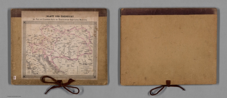
Author
Mayer, Alexander
Full Title
(Covers to) Post- und Eisenbahn-Karte der Osterreichisch-Ungarischen Monarchie. Herausgegeben vom Post-Cours-Boureau des K.K. Handelsministeriums In XVI. Blättern, im Maasse 1: 576,000. Entworfen vom k.k. Postrathe A. Mayer. Gezeichnet von K. K. Postloffizialen Joh. Gottwald u. Jos. Broditzky. Druck u. verlag v. R. v. Walheim in Wien.
List No
13387.001
Note
Loose cover with ties and index sheet on the cover.
Author
U.S. General Land Office
Full Title
(Covers to) Department of the Interior, General Land Office. Geographical and political atlas of the states and territories of the United States of America in which the Public Land Surveys are now in operation. S.S. Burdett, Commissioner. Washington City. 1876. Julius Bien, Photolith. & Print.
List No
11179.001
Note
Atlas in 20 plates,19 color maps. Including:1- New Mexico. 2-Idaho. 3-Kansas. 4-Washington. 5-Louisiana. 6-Dakota. 7-Nebraska. 8-Wyoming. 9- Arizona. 10-Utah. 11-Nevada. 12-Indian Territory.- 13-Oregon. 14-Montana. 15-Florida. 16-California in 2 shoots. 17-Minnesota. 18-Colorado. Maps showing land offices, townships subdivided, county seats, cities, towns, boundaries of land districts, railroad limits, military reservations, boundaries of counties, and Indian reservations. "Compiled from the official records of the General Land Office and other sources by C. Roeser, Principal Draughtsman G.L.O."
Author
[Andreas, A. T. (Alfred Theodore), 1839-1900, Baskin, Forster and Company]
Full Title
(Covers to) Illustrated historical atlas of the State of Indiana. Published by Baskin, Forster & Co. Lakeside Building Chicago, Ills. 1876. Engraved & Printed by Chas. Shober & Co. Props. of Chicago Lithographing Co.
List No
0019A
Note
A.T. Andreas is the "hidden" author due to his bankruptcy. Atlas is bound in half leather black cloth covered boards with "Illustrated Historical Atlas Of The State Of Indiana 1876" stamped in gilt. Most maps printed in full color, a few hand col.
Author
[Bancroft, A.L., Knight, W.H.]
Full Title
(Covers to) Bancroft's Map Of California, Nevada, Utah And Arizona. Published By A.L. Bancroft, & Compy. Booksellers & Stationers San Francisco Cal. 1876. Entered ... by A.L. Bancroft & Company ... Washington, D.C.
List No
0047.001
Note
Additional railroads when compared to the 1873 edition. Full color by county. Folded into dark brown cloth covers 16x11 with title "Bancroft's Map Of California, Nevada, Utah & Arizona." in gold. Relief shown by hachures.
Author
William P. Humphreys & Co.
Full Title
(Covers to) Atlas of the city and county of San Francisco from actual surveys and official records. Compiled and published by Wm. P. Humphreys & Co., A.B. Holcombe, W.C. Kewen. Eng. by Worley & Bracher ... Phila, Pa. Printed by F. Bourquin ... Phila, Pa. 1876.
List No
0329A
Note
Half leather brown cloth covers with "Atlas of the city & county of San Francisco. W.P. Humphreys & Co." stamped in gilt.
Author
King, Clarence
Full Title
(Covers to) Engineer Department U.S.A. Geological and Topographical Atlas Accompanying the Report of the Geological Exploration of the Fortieth Parallel Made by the Authority of the Honorable Secretary of War under the direction of Brig. and Brvt. Major General A.A. Humphreys, Chief of Engineers U.S.A. by Clarence King, U.S. Geologist in Charge, 1876. Julius Bien Lith.
List No
0408A
Author
Ludlow, William
Full Title
(Covers to) Report of a Reconnaissance From Carroll, Montana Territory, on the Upper Missouri, to the Yellowstone National Park, and Return Made in the Summer of 1875, by William Ludlow ... Washington: Government Printing Office. 1876.
List No
0446.001
Note
Early maps of Yellowstone; Wheat 1257,1258,1259. 155 pages, illustrations, plates , and 3 folded uncolored maps. Bound with blue cloth covered boards with title on spine in gold "Carroll Montana to Yellowstone National Park; Ludlow 1875." Contents includes: General report, by W. Ludlow.--Trip to the Judith basin; trip form Carroll to Ellis, by R. E. Thompson.--Zoological report, by G. B. Grinnell.--Geological report, by E. S. Dana and G. B. Grinnell.--Description of new fossils, by R. P. Whitfield.
Author
Andriveau-Goujon, Eugène
Full Title
(Covers to) Environs de Paris dans un rayon de 30 kilomètres
List No
10193.002
Note
Cover has "Librairie S. Brasseur Aine" printed in gold.
Author
[Union Atlas Co., Warner & Beers]
Full Title
(Covers to) Atlas of the State of Illinois to which are added various general maps, history, statistics and illustrations. Union Atlas Co., Warner & Beers, Proprietors. Lakeside Building Cor: of Clark & Adams Sts. Chicago. 1876. Entered ... 1876 by Warner & Beers ... Washington D.C.
List No
1159A
Note
This is very much in the Andreas Minnesota Atlas style - Warner and Beers in fact collaborated with Andreas and did the coloring on the Minnesota Atlas. This 1876 edition bears little resemblance to the earlier 1871 edition by Warner, Higgins & Beers (see our #3749) which used entirely different maps and had no views. Bound in half leather dark brown cloth covered boards with "Atlas of Illinois 1876 illustrated" stamped in gold on the front and blind stamped on the back.
Author
Ilyin, A.
Full Title
(Covers/Contents to) Podrobnyi Atlas Aziatskoi Rossii. Oglavlenie. S. Peterburg. Izdaniye Kartograficheskaya Zavedeniya A. Ilina. 1876. Tsevne z rub ser.
List No
11743.001
Note
Detailed Atlas of the Asian part of Russia with plans for major cities. Issued by Cartographic Institution, Alexey Ilyin, St. Petersburg, Contains 12 folded maps covering the vast Asian domains of the Russian Empire at an especially critical time in Russian and Asian history. Also represents the most complete information on geography, nature, population, social sphere, economy, history and culture of the country. Maps show political and administrative divisions, major cities, capitals, towns, rivers, roads and railroads. Bound in green paper covers with title and table of contents from the front cover. Alexey Ilyin, Russian lieutenant general, cartographer, publisher. produced many geographic atlases and maps, scientific, statistical, and special for different ministries, departments of mining, postal and telegraph, for scientific societies, including the Academy of Sciences and the Russian Geographic Society and for the Academy of Arts. In 1864 his lithography business was transferred to the embankment of the Kryukov Canal, where it was considerably expanded and got the name "Cartographic institution." In 1876 he issued a detailed atlas of Russia Empire.
Author
Vuillemin, A.
Full Title
(Covers to) Composite (Vuillemin and Logerot) Atlas.
List No
12051.001
Note
Mottled green paper covered boards with linen spine with damaged red label and text in gilt: "Carte Geographique de la Maison Logerot Pere Fils". Assemblage of maps from A. Logerot, editor and publisher. Date based on only map with date. This is a huge atlas (88 cm tall folio) that must have been used in French high schools - it is not listed in worldcat as an atlas, but a few of the maps are listed separately with dates from the 1860's to the 1870's. The maps are very well done.
Author
Everts, Ensign & Everts
Full Title
(Covers to) Combination Atlas Map Of Yates County New York. Compiled, Drawn and Published From Personal Examinations and Surveys. Everts, Ensign & Everts, 714 & 716 Filbert St. Philadelphia. 1876. Thos. Hunter Pr. Phila. N. Friend, Engr. Philad. C.L. Smith, Del.
List No
1828.001
Note
Bound in half leather brown cloth covered boards with "New Historical Atlas Of Yates County New York Illustrated. Everts, Ensign & Everts. 1876." decoratively embossed in gilt on the front cover and blind stamped on the back.
Author
[Geological and Geographical Survey of the Territories (U.S.), Powell, John Wesley, 1834-1902]
Full Title
(Covers to) Atlas accompanying the report on the geology of a portion of the Uinta Mountains and a region of country adjacent thereto by J.W. Powell, Geologist in charge 1876. Julius Bien Lith. Department of the Interior, U.S. Geographical and Geological Survey of the Territories, Second Division.
List No
2078A
Note
Atlas only. 2 maps, 6 diagram/maps. Bound folio, half leather marbled paper covered boards, with label printed with above title. Maps in full printed color; diagrams without color.
Author
Thompson & West
Full Title
(Covers to) Historical atlas map of Santa Clara County, California. Compiled, drawn and published from personal examinations and surveys by Thompson & West, San Francisco, Cala. 1876. Thos. Hunter Pr. Phil. N. Friend, Engr. Philad. C.L. Smith, Del.
List No
2256A
Note
Full color. Atlas is bound in half leather brown cloth covered boards with "New historical atlas of Santa Clara Co. California. Illustrated. Thompson & West 1876" stamped in gilt on the front cover and blind stamped on the back. David Rumsey Collection copy includes 3 ms. letters regarding the Almaden Mine view dispute.
Author
Wheeler, G.M.
Full Title
(Cover to) War Department Corps of Engineers. U.S. Army. U.S. Geographical Surveys West Of The One-Hundredth Meridian. Topographical Atlas. Wheeler. 1878.
List No
2738C
Author
Wheeler, G.M.
Full Title
(Cover to) Geographical Explorations And Surveys West Of The 100th Meridian. Geological Atlas. Wheeler. 1874.
List No
2738D
Author
Williams, G. Washington
Full Title
(Covers to) Williams' Copper - Plate Map Of The United States, Canada, Mexico, Central America, West Indies, &c. Published by John M. Atwood, 402 Locust Street, Philadelphia. Printed by F. Bourquin, 31 So. 6th Street, Phila. Copyright 1876 by G. Washington Williams.
List No
3030.001
Author
McDonough, Leo & Co.
Full Title
(Covers to) An Illustrated Historical Atlas Map Of Daviess County, Ky. Carefully Compiled from Personal Examinations and Surveys. Published by Leo McDonough & Co. 1876.
List No
3389.001
Note
Bound in half leather dark brown cloth covered boards with "Illustrated Historical Atlas Of Daviess Co. Kentucky." stamped in gold.
Author
Colton, G.W. & C.B.
Full Title
(Covers to) Map Of The Country Thirty Three Miles Around The City Of New York. Published By G.W. And C.B. Colton, & Co., 172 William St. New York. Entered ... 1846, by J.H. Colton ... New York. Drawn by G.W. Colton. Engraved by J.M Atwood, N.Y. 1876.
List No
3515.001
Note
Extensive railroad growth is the most noticeable difference from the 1865 edition. Full color. Map is folded into dark brown cloth covers 14.5x9 with "Colton's Map Of The Country Thirty Three Miles Around The City Of New-York G.W. & C.B. Colton & Co." in gilt.
Author
Davis, F.A.
Full Title
(Covers to) New Illustrated Atlas Of Lehigh County, Pennsylvania. Compiled & Drawn from Personal Examinations, Surveys & Under the Personal Supervision of F.A. Davis. and Published under the Superintendence of H.L. Kochersperger By The Reading Publishing House, Reading, Pa. A.M. Davis Successor to F.A. Davis & Co. 1876. Copyright 1876, By O.W. Gray & Son, & F.A. Davis & Co. Maps & Atlases Plain and Colored Lithographing Engraving on Wood or Stone ... Historical Works & Charts ...
List No
3745.001
Note
Bound in half leather black cloth covered boards with a round burgandy cloth label stamped with "New Historical Atlas Of Lehigh County Pennsylvania, Illustrated. Reading Publishing House. 1876" in gilt.
Author
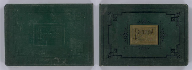
[Compton, Richard J., Dry, Camille N.]
Full Title
(Covers to) Pictorial St. Louis, the great metropolis of the Mississippi Valley; a topographical survey drawn in perspective A.D. 1875, by Camille N. Dry, designed & edited by Rich. J. Compton. St. Louis. Compton & Company, 1876. Western Engraving Co. St. Louis.
List No
4209A
Note
Bound in dark green leather covered boards with a decorative framed title embossed in gold reading "Pictorial Saint Louis."
Author
Lloyd, H.H.
Full Title
(Covers to) Lloyd's Dollar Map Of The Western States. Published By H.H. Lloyd & Co. 170 Fulton Street, New York. Copyright 1876, by H.H. Lloyd & Co.
List No
4420.001
Note
Shows the area from eastern Ohio to western Nebraska, from the Canadian border south to the 37th parallel. The cartouche is a large United States "Trade Dollar 420 Grains 900 Fine." Railroads lines are shown in profusion, with some roads indicated in the less populated western counties. The progression of settlement to the west and north is clearly shown. The only issue of this map in Karrow. Lloyd also made similar maps of the other U.S. regions (see P-Maps 927). Full color by county. Folded into brown cloth covers 17.5x11 with black oval label reading "Lloyd's "Dollar" Map Series. Western States. H.H. Lloyd & Co., New York." Prime meridian is Washington D.C.
Author
Beers, F.W.
Full Title
(Covers) Illustrated Atlas of the City of Richmond, Published for the Southern and Southwestern Surveying and Pub. Co. by F.W. Beers, C.E. J.A. Enslow, Jr., J.P. Brown, Business Managers ... Entered ... 1876 by F.W. Beers ... Washington ...
List No
4623.001
Note
Atlas is bound in half leather dark brown cloth covered boards with "Illustrated Combination Atlas Of Richmond, Va. 1876." decoratively embossed in gilt on the front and back covers.
Author
[Beers, F.W. (Frederick W.), Cramer, Louis H.]
Full Title
(Covers to) Combination Atlas Of Saratoga And Ballston From Recent And Actual Surveys And Records Under the Superintendence of F.W. Beers And Louis H. Cramer, Published By J.B. Beers & Co. 36 Vesey Street, New York. 1876. Entered ... 1876 by J.W. Beers & Co. ... Washington. Printed by Charles Hart, 36 Vesey St. N.Y. Engraved by L.E. Neuman 36 Vesey St. N.Y.
List No
4629.001
Note
Atlas is bound in full black leather covered boards with "Combiination Atlas Of Saratoga And Ballston. F.W. Beers And Louis H. Cramer. 1876" stamped in gold.
Author
[Beers, J.B. & Co., H.W. Burgett and Company]
Full Title
(Covers to) Illustrated topographical and historical atlas of the State of Vermont. Published by H.W. Burgett & Co. 36 Vesey Street, New-York. 1876. Entered ... 1876 by H.W. Burgett & Co. ... Washington D.C. Engraved & printed by J.B. Beers & Co. 36 Vesey St. N.Y.
List No
4633A
Note
This scarce atlas is styled after the Andreas atlases of Iowa and Minnesota, although the views are more frequently of commercial establishments than homes or farms. It is very well done, and the only known production of H.W. Burgett. County maps in full color by township. Covers are half leather black cloth covered boards with "Illustrated Combination Atlas Of Vermont. 1876. Freedom And Unity" embossed in gilt on the front and back. Irregular paging.
Author
Hopkins, G.M.
Full Title
(Covers to) City Atlas Of Newport Rhode Island From official Records Private Plans and Actual Surveys, Based upon Plans deposited in the Department of Surveys. Surveyed & Published under the Direction Of G.M. Hopkins, C.E. 320 Walnut Street, Philadelphia. 1876. Engraved by Edward Busch, 320 Walnut Street. Printed by F. Bourquin, 31 So. 6th Street Phila. Entered ... 1876 by G.M. Hopkins ... Washington D.C.
List No
4831.001
Note
Bound in half leather dark brown cloth covered boards embossed with "Atlas Of Newport Rhode Island. G.M. Hopkins." in gilt. Title is blind stamped on back cover.
Author
Blanchard, Rufus
Full Title
(Covers to) Blanchard's Guide Map of Iowa. Published by Rufus Blanchard 132 Clark Street. Chicago 1876.
List No
4948.001
Note
In addition to Iowa, this shows large portions of Minnesota, Wisconsin and Illinois - suggesting it was taken from a large wall map of the U.S. Full color. With 16 pages of population statistics from the Ninth Census, and an excellent catalog of Blanchard's publications. Folded into mint green paper covers 14x8.5 with "Guide Map Of Iowa. Published By Rufus Blanchard 132 Clark Street, Chicago." printed in black. Printed around the border of the cover title is the advertisement "Blanchard's Historical Map of the United States Illustrates History by locating its Decisive Events where they took place. Price, $8.00, Address R. Blanchard, Chicago, Ill."
Author
Caldwell, Joseph A.
Full Title
(Covers to) Caldwell's Illustrated, Historical, Centennial Atlas Of Greene County, Pennsylvania. From actual Surveys by & under the directions of Henry Cring, C.E. Assisted by C.T. Arms, Sr. C.E. J.A. Underwood, C.E. J.A. Howden. P.L. Mason. W.J. Kerstetter, C.E. W.F. Arms, C.E. H. Cring, C.E. Published By J.A. Caldwell, Condit, Ohio. 1876. Engraved, Lithographed & Printed By Otto Krebs, Pittsburgh, Pa.
List No
4974.001
Note
Bound in half leather dark teal cloth covered boards with "Caldwell's Illustrated Combination Centennial Atlas Of Greene Co. Pennsylvania. by J.A. Caldwell. 1876." stamped in gold.
Author
Drew, Columbus
Full Title
(Covers to) Drew's New Map Of The State Of Florida Showing the Townships by the U.S. Surveys, the Completed & Projected Railroads, The Different Railroad Stations And Growing Railroad Towns, The New Towns on the Rivers and interior, and the New Counties, up to the Year 1876. Published by C. Drew, Bookseller & Stationer, Jacksonville, Fla. Entered ... 1873, by Columbus Drew ... Washington.
List No
5040.001
Note
The copyright date is 1873; there was an 1874 edition, then this 1876 edition, and an 1877 edition. The first edition was probably 1870 (see our #5190). Fitzgerald lists Julius Bien as the engraver of the 1874 edition - his name is absent from this 1876 edition. A fine, scarce pocket map of Florida published in Jacksonville, Florida, and the only map in the Fitzgerald list and in Phillips Maps published by a Floridian in the 1800's. Several existing and proposed railroads are shown, and the map is generally thick with detail of emerging towns, roads, historic sites, etc. Map is folded into green cloth covers 15x10 with "Drew's Florida" stamped into an illustration of an armored arm stamped in gilt.
Author
Caldwell, Joseph A.
Full Title
(Covers to) Caldwell's Illustrated, Historical, Centennial Atlas Of Beaver County, Pennsylvania. From actual Surveys by & under the directions of J.A. Caldwell. Assisted by C.T. Arms, Sr. C.E. J.A. Underwood, C.E. J.A. Howden. P.L. Mason. W.J. Kerstetter, C.E. W.F. Arms, C.E. J.J. Power, C.E. Published By J.A. Caldwell, Condit, Ohio. 1876. Engraved, Lithographed & Printed By Otto Krebs, Pittsburgh, Pa.
List No
5043.001
Note
Engraved and printed by Otto Krebs of Pittsburgh, with hand colored views. One of four Pennsylvania county atlases printed by Krebs with hand colored views - see also Clarion, Warren and Greene Counties. This copy also has two outstanding lithographic color views (Western File Works and Soldiers' Orphan School) that may not be in all copies. Lacking one half of two pages of views. Full color. Atlas is bound in half leather brown cloth covered boards stamped with "Caldwell's Illustrated Combination Centennial Atlas Of Beaver County, Pennsylvania. by J.A. Caldwell. 1876." in gold.
Author
Texas Land and Immigration Company
Full Title
(Covers to:) Map of the state of Texas. Woodward, Tiernan & Hale, Map Engr's St. Louis. Texas Land and Immigration Co. St. Louis, Mo. (1876)
List No
5049A
Author
Beers, Frederick W.
Full Title
(Covers to) Plan Of Berkshire Co. Massachusetts. Published Expressly For S. E. Nichols, Bookseller & Stationer, Pittsfield, Mass. Copyrighted 1876, by F. W. Beers & Co. (inset) Pittsfield. Scale 160 Rods to the inch.
List No
5429.001
Note
Uncolored map with hachures enclosed in a 15x10 brown cloth covered case with "Map of Berkshire County Mass." in gilt on front.
Author
Watson, Gaylord
Full Title
(Covers to) Watson's New County and Railroad Map of the Pacific States Published by G. Watson, No. 16 Beekman Street, New York. 1876. Engraved by Louis E. Neuman, 36 Vesey St., New York. Entered ... 1874 by Gaylord Watson ... Washington.
List No
5568.001
1-34 of 34
|