|
REFINE
Browse All : Covers from 1855
1-49 of 49
Author
Betts, John
Full Title
(Covers to) Astronomical Recreation
List No
15967.001
Note
Date estimated.
Author
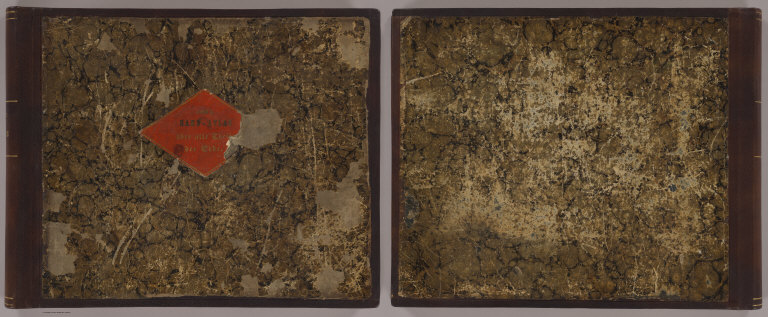
Dépôt General de la Marine
Full Title
(Covers to) [French composite sea atlas focusing on colonization in Southeast Asia].
List No
14392.001
Note
Covers to [French composite sea atlas focusing on colonization in Southeast Asia]. Large folio bound in black-and-pink speckled board with contemporary red roan spine. Gilt ornamentation on spine.
Author
Wyld, James, 1812-1887
Full Title
(Covers to) Map Of The Countries Between England & India Designed to shew the Over-Land And Sea-Routes To The East, The Line Of Communication With Our Indian Possessions and the relative position of Russia To England & Hindostan By James Wyld. London, Published by Jas. Wyld, Geographer to the Queen & H.R.H. Prince Albert, Charing Cross, East & Model of the Earth Leicester Square. (inset) Sketch From England To China.
List No
3902.001
Note
Date estimated
Author
W. & A.K. Johnston
Full Title
(Covers to) Johnstons' atlas of the war. W. & A.K. Johnston. Geographer & Engravers to the Queen. Edinburgh. 1854-1855.
List No
8367.001
Note
7 color maps in slip case, on sheets 53.5x69, or 69x53.5. Each map individually titled, folded into self wrapped cover, placed into red card board slip case, 23.5x14, with manuscript list of maps. Maps showing railways, fortified places, major cities, towns and villages, principal roads, railroads, churches, etc. Includes descriptive and dated notes, statistical tables. Relief shown by hachures. Prime meridian is Greenwich. Map of Southern Russia, 1855. Danubian Principalities & Turkey 1854. Chart of the Baltic Sea Cronstadt &c. Map of the Crimea, 1855. Map of the Black Sea 1855. Plan of the Siege of Sevastopol. Chart of the Sea of Azov. 1855.
Author
W. & A.K. Johnston
Full Title
(Covers to) Johnstons' new map of the seat of war in the Danubian prinicipalities and Turkey with the adjoining countries. With map of central Europe, 1854. Tenth edition. W. & A.K. Johnston. Geographer & Engravers to the Queen, 4 St. Andrew Square, Edinburgh. (to accompany) Johnstons' atlas of the war-1855.
List No
8367.002
Note
Cover to fold out map.
Author
W. & A.K. Johnston
Full Title
(Covers to) Johnston's Chart of the Baltic Sea, German Ocean & English Channel. With the adjoining countries : Showing principal lines of railway communication to the coasts of Northern Europe, with enlarged plans of Cronstadt, Sveaborg, Revel, Port Baltic & Gulf of Riga. 1855 -- W. & A.K. Johnston, Geographer & Engraver to the Queen, 4 St. Andrew Square, Edinburgh. (to accompany) Johnstons' atlas of the war-1855.
List No
8367.004
Note
Cover to fold out map.
Author
W. & A.K. Johnston
Full Title
(Covers to) Johnstons' New map of the Crimea : with a plan of the town and port of Eupatoria and a sketch map shewing the relative position of the Crimea with the seat of war in the east, 1855 -- W. & A.K. Johnston. Geographer & Engravers to the Queen, 4 St. Andrew Square, Edinburgh. (to accompany) Johnstons' atlas of the war-1855.
List No
8367.006
Note
Cover to fold out map.
Author
W. & A.K. Johnston
Full Title
(Covers to) Johnstons' New map of the Black Sea, Caucasus, Crimea & c : with enlarged plans of Sevastopol as seen by the officers of H.M.S.F. Retribution 6th. January 1854 and the Bosporus, 1854 -- W. & A.K. Johnston. Geographer & Engravers to the Queen, 4 St. Andrew Square, Edinburgh. (to accompany) Johnstons' atlas of the war-1855.
List No
8367.008
Note
Cover to fold out map.
Author
W. & A.K. Johnston
Full Title
(Covers to) Johnstons' chart of the Sea of Azov, with a map of the grain producing portion of Russia whence it derives ut commerce. 1855 -- W. & A.K. Johnston, Geographer & Engraver to the Queen, 4 St. Andrew Square, Edinburgh. (to accompany) Johnstons' atlas of the war-1855. .
List No
8367.012
Note
Cover to fold out map.
Author
W. & A.K. Johnston
Full Title
(Covers to) Johnstons' map of Southern Russia : extending from Kinburn to Kief and from Mohilev to Berdinsk. 1855 -- W. & A.K. Johnston, Geographer & Engraver to the Queen, 4 St. Andrew Square, Edinburgh. (to accompany) Johnstons' atlas of the war-1855.
List No
8367.014
Note
Cover to fold out map.
Author
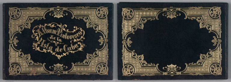
[May B. y Ca., Storch & Kramer, Miahle, Pierre Toussaint Frederic]
Full Title
(Covers to) Album Pintoresco de la Isla de Cuba. B. May y Ca. Oilprinting Storch & Kramer, Berlin.
List No
11398.001
Note
27 chromolithograph views and gold lithographed pictorial title page with two folded maps of Cuba and plan of Havana. Some views with Spanish and English title. The views include Havana and other areas of Cuba, general city views, historic sites, landmarks, street scenes of daily life and folk customs in rural villages, and urban views including people in period dress. Bound in red leather covers ornamented in gold, with title embossed on the front cover in gilt. Oilprinting Storch & Kramer for B. May y Ca., One of two pirated editions printed in Germany in the 1850's, views based on the work of French-born painter Pierre Toussaint Frederic Mialhe, who lived in Cuba from 1838-54. Mialhe was employed by the printing firm Real Sociedad Patriotica to compile a pictorial record of the island, in his Viaje Pintoresco al Rededor de la Isla de Cuba (Havana, 1847-1848). Date estimated. The two maps were also published separately, see our 5444.000 and 5445.000.
Author
Preyssinger, Ludwig
Full Title
(Covers to) Astronomischen Bilderatlas von Ludwig Prentzinger … Schwaeb. Hall. Druck und Berlag von Wilhelm Nitzschke. (Astronomical Images Atlas of Ludwig Prentzinger ... Schwäb. Hall. Printed and Published by William Nitzschke).
List No
7990.001
Note
Folio covers with tie string. Dark brown with gilt lettering, "Astronomischer Bilder-Atlas" and stamped pattern. Blind stamped on the back. Folding internal paper covers keep enclosures contained.
Author
Colton, J.H.
Full Title
(Covers to) Texas. Published by J.H. Colton & Co. No. 171 William St. New York. Entered according to Act of Congress in the year 1855, by J.H. Colton & Co. ... New York (insets) Plan of Galveston Bay -- Plan of Sabine Lake.
List No
6823.001
Note
Rare first edition of the Colton map of Texas in pocket map form. Outline color map, 31 1/2x40 folded and bound in brown cover, 10 1/2x8 1/2 with "Map of Texas, J.H. Colton" stamped in gilt. Relief shown by hachures. Prime meridians are Greenwich and Washington. On verso of cover: J.H. Colton's geographical Publishing advertisement. Includes note and explanation. Showing roads, railroads, cities and towns.
Author
Goodwin, F.A.
Full Title
(Covers to) Map Of California And The Adjacent Country. Compiled by F. Goodwin From the best Authors and actual Observation. Entered ... 1855 by F. Goodwin ... New York. Lith. of Geo. E. Leefe, 223 Fulton St. N.Y. (with 8 page description) A Brief Description of California, From The Time of Its First Occupation by the United States and Subsequent Growth ... Accompanied by a Map of California and adjacent Country.
List No
3438A
Author
Chapman, Silas
Full Title
(Covers to) Wisconsin, A Sectional Map With The Most Recent Surveys. Published by Silas Chapman. Milwaukee, Wisc. 1855. Entered ... 1853 by S. Chapman ... Wisconsin Lith of F. Mayer & Co. 96 Fulton St. N. Y.
List No
0138.001
Note
Shows the surveyed southern portion of the state - changes from the 1853 edition are mostly the extension of public surveys in the north. Karrow shows four different Wisconsin maps issued by Chapman in 1855, all on the same scale - two show the entire state and two (including this one) show the southern portions. Outline color. Folded into textured brown cloth covers 13.5x9 with "Sectional Map Of Wisconsin, Containing The Most Recent Surveys. New Edition. Published by S. Chapman, Milwaukee." printed in black on beige paper label.
Author
Colton, J.H.
Full Title
(Covers to) Colton's Railroad & Township Map Of The State Of New York, With Parts of the Adjoining States & Canada. Published by J.H. Colton & Co. No. 172 William St. New York 1855. Entered ... 1852, by J.H. Colton ... N. York. Drawn by Geo. W. Colton. J.M. Atwood Sculpt.
List No
0179.001
Note
The first issue was probably 1852 or 1853 - this map is not in Phillips. Full color by county, folded into dark brown cloth covers 14.5x9 with "Township Map Of The State Of New-York Published By J.H. Colton" in gilt. Prime meridians are Greenwich and Washington D.C. Relief shown by hachures.
Author
[Colton, J. H., Colton, G. Woolworth]
Full Title
(Covers to) Colton's Township Map Of The State Of Iowa Compiled from the United States Surveys, & other Authentic Sources. Published By J.H. Colton And Co. No. 172 William St. New York. 1855. Entered ... 1851, by J.H. Colton ... New York. Drawn by Geo W. Colton. Engraved by J.M. Atwood.
List No
0180.001
Note
The fifth edition. Omaha City is shown for the first time, with the railroad connection from the east. Full color by county, folded into stamped black cloth covers 14.5x9 with "Township Map Of The State Of Iowa Published By J.H. Colton" in gilt.
Author
[Griffith, Richard John,; Sir; (1784-1878), Ireland, Railway Commissioners]
Full Title
(Covers to) A General Map Of Ireland to Accompany the Report of the Railway Commissioners shewing the Principal Physical Features and Geological Structure Of The Country. Constructed In 1836 And Engraved In 1837-8. The Geology Revised And Improved In 1855. Published And Sold By Hodges & Smith, Dublin, And Longman & Co., London. With whom Copies coloured Geologically are deposited. Price Twenty Shillings Plain ...
List No
0337.001
Note
1st ed. was 1836/7; Signed by Griffith & Larcom (perhaps printed signatures). Not colored Geologically, but politically with the Railroads. Originally published to accompany the Atlas to accompany the second Report of the Railway Commissioners, 1837. Map is in four sheets, each dissected into 20 sections. Full color. Sheets have marbled end papers and fold into a black leather covered slip case 25x18 with "Map Of Ireland. Stanford" stamped in gilt on the spine.
Author
Minard, Charles Joseph, 1781-1870
Full Title
Carte figurative et approximative des tonnages de marchandises qui ont circulé sur les chemins de fer et les voies d'eau en France en 1853. [Flow of merchandise in France on railways and waterways in the year 1853].
List No
10139.001
Note
Folds into covers with label "Tonnages 1853" Robinson, no.10. Signed by Minard. This map is part of a 9 map subset of the 15 Minard maps that shows the flow of merchandise in France on railways and waterways in the years 1850 to 1861, Pub List No.'s 10138.000 to 10146.000
Author
Minard, Charles Joseph, 1781-1870
Full Title
(Covers to) Carte figurative et approximative des tonnages de marchandises qui ont circulé en 1855 sur les voies d'eau et fer de l'Empire français. [Flow of merchandise in France on railways and waterways in the year 1855].
List No
10140.001
Note
Folds into covers with label "Tonnages 1855" Robinson, no.12. This map is part of a 9 map subset of the 15 Minard maps that shows the flow of merchandise in France on railways and waterways in the years 1850 to 1861, Pub List No.'s 10138.000 to 10146.000
Author
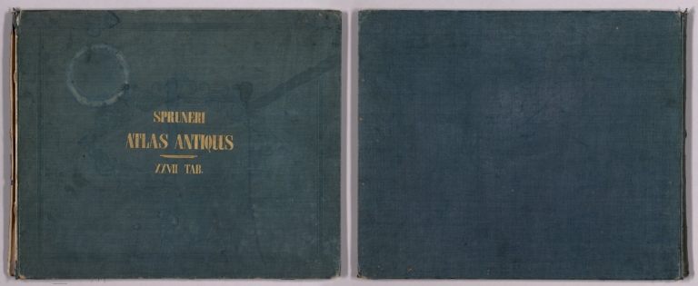
[Spruner von Merz, Karl, 1803-1892, Menke, Theodor 1819-1892, Alt, Guil, Alt, W., Edler]
Full Title
(Covers to) Atlas antiquus delineavit Dr. C. Spruner. XXVII tabulas coloribus illustratas et alias LXIV tabellas in margines illarum inclusas continens. Editio secunda. Gothae: Sumitibus Justi perthes. Anno MDCCCLV (1855). (half title page)Dr. Karl von Spruner's Historisch-geographischer Hand-Atlas : erste abtheilung : Atlas antiquus. Sieben und Zwanzig in Kupfer gestochene colorirte Karten mit Vier und Sechzig Nebenkarten nebst erlauternden Vorbemerkungen. (Cover title) Spruneri Atlas- Antiquus. XXVII Tab.
List No
11676.001
Author
[Ewald, Ludwig 1813-1881, Bauerkeller, Georg Leonhart]
Full Title
(Section Title Page) Handatlas der Allgemeinen Erdkunde, der Laender- und Staatenkunde ... in 80 Karten ... Bearbeitet von L. Ewald ... Heft 28 & 29 ... Darmstadt, 1855.
List No
12189.156
Author
Anonymous
Full Title
(Covers to) Atlas der Evangelisch - Lutherischen Gemeinen in Russland. St. Petersburg. Buchdruckerei der Kaiserlichen Akademie der Wissenschaften. 1855.
List No
12378.001
Note
Blue paper covers with black text.
Author
[Jervis, Thomas Best, von Weiss, Franz]
Full Title
(Covers to) Topographical Map Greece, Turkey in Europe, the Archipelago and Part of Asia Minor indicating the Classical as well as Modern Names, and the Sites of Ancient Ruined Cities; together with a General Map of Asia Minor, Syria, Caucasia, and the Black Sea ... from the Original Map Constructed by Lt. Franz von Weiss ... by ... Thomas Best Jervis ... War Department ... London: - John Petheram, Publisher, 1855.
List No
12432.001
Note
Sample shown of the blue marbled paper pasted on the back of two of the panels of each sheet.
Author
Stummer, Joseph
Full Title
(Covers/Title Page to) Bildliche Darstellung der Geschichte der ausschl. privil. Kaiser Ferdinand`s Nordbahn vom Beginn des Betriebes bis zum abgelaufenen Jahre. Entworfen end bearbeitet von Josef. Stummer, Lithographie und farbendrund von H. Engle. Wien 1855. (Pictorial representation of the history of Emperor Ferdinand's Northern Railway from the beginning of its operation until the past year. Designed by Josef. Mute, lithograph and full color by H. Engle. Vienna 1855.)
List No
13248.001
Author
Stummer, Joseph
Full Title
(Covers to) Bildliche Darstellung der Geschichte der ausschl. privi. Kaiser-Ferdinand`s- Nordbahn, von dem zeitpunkt der eroffnung im jahre 1838 bis zu eude des jahres 1853. Druck von Keck & Pierer in Wien. Entworfen end bearbeitet von Josef. Stummer, Lithographie und farbendrund von Hermann Engle. Wien 1855.
List No
13248.012
Note
Front and back covers to booklet in 8 pages on the development of the Kaiser Ferdinands Nordbahn from the beginning of the operation on 1838 to the end of the year 1853.
Author
Henn, Williams & Co.
Full Title
(Covers to) A Township Map Of The State Of Iowa. Compiled from the United States Surveys, official information and personal reconnaissance, showing the Streams, Roads, Towns, County Seats, Works of Internal Improvement, &c. &c. Published by Henn, Williams & Co. Fairfield, Iowa. and by R.L. Barnes, Philadelphia. No. 6 South 7th. Street 1855. Friend & Aub Lith. Phila. Entered ... 1854, by R.L Barnes ... Penna.
List No
1739.001
Note
Early 1855, with the plate changed entirely from the 1851 issue. Shows "Great Western Mail & Emigrant Route to the Pacific" extending from Omaha. Full color. Folded into stamped red cloth covers 15x10 with "Henn, Williams & Co.'s Township Map Of Iowa" in gilt. Prime meridian is Washington D.C.
Author
Henn, Williams & Co.
Full Title
(Covers to) A Township Map Of The State Of Iowa. Compiled from the United States Surveys, official information and personal reconnaissance, showing the Streams, Roads, Towns, County Seats, Works of Internal Improvement, &c. &c. Published by Henn, Williams & Co. Fairfield, Iowa. and by R.L. Barnes, Philadelphia. No. 6 South 7th. Street 1855. Friend & Aub Lith. Phila. Entered ... 1854, by R.L Barnes ... Penna.
List No
1994.001
Note
Late 1855, showing "U.S. Military Road to St. Paul" extending northeast from Sioux City. Folded into stamped brown cloth covers 14.5x9.5 with "Henn, Williams & Co.'s Township Map Of Iowa" in gilt. Full color. Prime meridian is Washington D.C.
Author
Colton, J.H.
Full Title
(Covers to) Colton's Railroad & Township Map Of The State Of Maine With Portions Of New Hampshire, New Brunswick & Canada. Published By J.H. Colton And Co. No. 172 William St. New York, And C.C. Hall, Portland, Maine. 1855. Entered ... 1855 by J.H. Colton ... New York.
List No
2720.001
Note
With C.C. Hall in Portland. Shows some differences with the 1856 wall map version, primarily at the forward edge of settlement in the north central region of the state; also some railroads are extended. In full color, folded into ornatedly embossed red leather covers 16x10.5 with "Township Map Of The State Of Maine Published By J.H. Colton" in gilt.
Author
[Smith, J. Calvin, Colton, J.H.]
Full Title
(Covers to) The Western Tourist And Emigrant's Guide Through The States of Ohio, Michigan, Indiana, Illinois, Missouri, Iowa and Wisconsin, And The Territories Of Minnesota, Missouri, and Nebraska ... Accompanied with a large and minute map, exhibiting the Township lines of the United States' Surveys ... New York: Published by J.H. Colton and Company, No. 172 William Street. 1855. (on verso) Entered ... 1850, by J.H. Colton ... New York.
List No
2734.001
Note
89 page guide book and 34 page Catalogue of Colton's publications. The map continues to change from earlier issues - counties in Minnesota for the first time, more railroads throughout, and spreading township and range lines. Full color map, 52x66, bound in back and entitled, "Guide Through Ohio, Michigan Indiana, Illinois, Missouri, Wisconsin & Iowa Showing The Township lines of the United States Surveys ... By J. Calvin Smith. 1855." At bottom, "Entered ... 1851, by J.H. Colton ... New York." Bound with brown cloth covered boards with title "Colton's Western tourist and emigrant guide" and two vignettes on the cover.
Author
Ensign, Bridgman & Fanning
Full Title
(Covers to) Map of Canada East And West. New York, Published by Ensign, Bridgman & Fanning. 156 William Street, 1855. Entered ... 1848 by Ensign's & Thayer ... New York. Printed by D. McLellan 26 Spruce St. N.Y. Entered ... 1853 by Ensign, Bridgman & Fanning ... New York. (untitled inset of Eastern Canada).
List No
2959.001
Note
A larger version was also published - Winearls 161. 1st issued in 1850. The larger version first issued in 1848. Outline color by county. Folded into black leather covers 14.5x9 with "Map Of Canada East And West." and decorative border in gilt.
Author
Colton, J. H.
Full Title
(Covers to) Ohio. Published By J.H. Colton & Co. No. 172 William St. New York. 1855. Entered ... 1855 by J.H. Colton & Co. ... New York. (inset) Vicinity Of Cleveland Cuyahoga Co.
List No
2983.001
Note
From Colton's Travelling Maps series. Possibly the first edition - Karrow lists nothing earlier than the 1856 atlas issue map. Full color by county, folded into patterned black cloth covers 12.5x8.5 with "Map Of Ohio J.H. Colton" in gilt. Prime meridians are Greenwich and Washington D.C.
Author
Colton, J. H.
Full Title
(Covers to) Maine. 1855. Published By J.H. Colton. No. 172 William St. New York. Entered ... 1853 by J.H. Colton ... New York.
List No
3167.001
Note
The map is the same as the 1855 American Atlas map of the same title except that it is dated 1855 in the title and has no page number (this is typical of the pocket maps derived from the atlas maps). Folded into stamped golden tan cloth covers 13x9 with "Map Of Maine J.H. Colton" in gilt. Prime meridian is Washington D.C.
Author
Green-Wood Cemetery
Full Title
(Covers to) Green-Wood Cemetery. 1855. Snyder, Black & Sturn, Lith. 87 Fulton St. N.Y.
List No
3241.001
Note
One of the earliest "planned" cemeteries. In Brooklyn. No indication of the map maker. Snyder, Black & Sturn are the lithographers. The plots are numbered (no index with the map) and show lots of room at the top of the map for the inevitable expansion. Folded into stamped green cloth covers 16x10 with "Green-Wood" in gilt.
Author
Colton, J. H.
Full Title
(Covers to) Arkansas. Published By J.H. Colton & Co. No. 172 William St. New York. 1855. Entered ... 1853, by J.H. Colton ... New York.
List No
3418.001
Note
The Travelling Maps version with census statistics on the verso. Differs from the 1855 atlas map in not showing Indian Territory, and having fewer railroads drawn and labeled. First issued in 1853. Folded into brown cloth covers 12.5x8.5 with "Map Of Arkansas J.H. Colton" in gilt. Prime meridians are Greenwich and Washington D.C.
Author
Ensign, Bridgman & Fanning
Full Title
(Covers to) Fanning's Map of New-York City, Published By Ensign, Bridgman & Fanning, 156 William Street, Corner of Ann. New York. 1855. Entered ... 1853, by Horace Thayer & Co. ... N. York. (with index titled) A Map Of The City And County Of New York, With The Adjacent Cities Of Brooklyn And Jersey City, And The Village Of Williamsburg: With A Street Directory Of The City Of New York. New York: Thayer, Bridgman & Fanning ... 1854. (on page 1) Corrected October 20, 1849. Entered ... 1849, by H. Wilson ... New-York.
List No
3614.001
Note
With inset views of The Merchants' Exchange, Institution for the Blind, and The Custom House. The title page of the directory is dated 1854, but the map is dated 1855. With a two page catalogue of maps and charts offered by Thayer, Bridgman & Fanning. See first edition by Ensigns & Thayer (1849). Map is folded into stamped brown cloth covers 14.5x9 with "Map Of New-York City E,B, & F." stamped in gilt.
Author
Dripps, Matthew
Full Title
(Covers to) Topographical Map Of New York City, County And Vicinity, Showing the Original High Water Lines, Permanent Pier Lines, and the Present Wharves & Piers, compiled from authentic surveys. Published By M. Dripps, No. 103 Fulton St. New York 1855. Entered ... 1853 by M. Dripps ... N.Y. (inset map) New York-County North of 155 Street. (inset) Nieuw Amsterdam opt Eylant Manhattans 1656. Map Of New Netherlands. (inset) New Yorke 1695.
List No
4208.001
Note
Entered in 1853. Not in Haskell, although Haskell lists another map of about the same size, insets, and scale, with a different title. The map covers all of Manhattan and parts of Brooklyn and the New Jersey shore. Topography is shown (similar to the Viele map of 1868) with particular emphasis on the original shoreline and the made land and docks. Central Park is indicated by color with no name given. A very attractive map of the city showing the rapid development northward. Full color. Covers are dark brown cloth 22x13.5 stamped in gold with "Bulkhead & Pier Lines, Brooklyn & New York." Scarce.
Author
Mitchell, Samuel Augustus
Full Title
(Covers to) A New Universal Atlas Containing Maps of the various Empires, Kingdoms, States and Republics Of The World. With a special map of each of the United States, Plans of Cities &c. Comprehended in seventy five sheets and forming a series of One Hundred And Twenty Nine Maps, Plans And Sections ... Philadelphia, Thomas, Cowperthwait & Co. No. 253 Market Street. 1855. Entered ... 1850 by Thomas, Cowperthwait & Co. ... Pennsylvania. (title page by) J. Wissler delr. Chromolith. of P.S. Duval & Co. Phila.
List No
4328.001
Note
Early 1855 edition. The Arkansas map has steamboat routes across the top. The Texas map is undated. New Jersey is dated 1854. See the late 1855 edition - further evidence that Mitchell updated the atlas at least twice a year. This copy belonged to Judah Chase (with his name gold stamped on the cover) who was a noted Blue Hill, Maine, Sea Captain and owner of the Brig Thomas M. Lyon. This ship sailed from Havre, France, at the end of March, 1836, and sank in a heavy gale off the Island of Jersey - but the crew was saved. The fine condition of this atlas suggests that it remained in Captain Chase's library and never went to sea. Maps are in full color. Bound in half leather dark green cloth covered boards with "Mitchell's Universal Atlas. Judah Chase." stamped in gold on the front label.
Author
Bromme, Traugott
Full Title
(Covers to) Post-Kanal-Und Eisenbahnkarte Der Vereinigten Staaten Von Nord-Amerika. Nach Smith, Tanner, Mitchell und den Berichten des General-Postamts bearbeitet Von Traugott Bromme in Stahl gestochen v. J.A. Buhler. Philadelphia Chestnut-Street 195, John Weik, Publisher & Importer. Stuttgart Hoffmann'fche Verlagshandlung. 1855. (inset) Oregon, California Und Der Mormonen-Staat: Deseret. (with 6 additional inset maps).
List No
4364.001
Note
In covers stamped "Map of the United States," this map was originally issued with Bromme's 16 page guide and map of the same title published in Stuttgart in 1853. This 1855 issue was published in Philadelphia by John Weik, has his name added to the map title and the map placed in his own covers with an advertisement for his "Unentbehrlich Fur Jedermann!!" The map, other than being very handsome overall, is clearly from another period (probably around 1840 - the Maine northern boundary is pre 1842) with some updates (not enough to satisfy Wheat - "primitive and backward looking") and, most interestingly, a nice inset of "Oregon, California Und Des Mormonen-Staat Deseret." Also includes six other inset maps: New York, Baltimore and Washington, Washington D.C., Philadelphia, Boston, and St. Louis. Rare with the Philadelphia imprint. Although similar to, this is not the same engraving (nor are the insets the same) as Bromme's "Neueste Eisenbahn-Kanal-U. Post-Karte fur Reisende in den Vereinigten Staaten von Nord Amerika..." that was copied almost directly from Smith's map (see our 1864 edition). Outline color by state, folded into brown leather covers 12.5x8 with "Map Of The United States" stamped in gilt. Prime meridian is Washington D.C.
Author
Ensign, Bridgman & Fanning
Full Title
(Covers to) Map Of Iowa. New York. Published By Ensign, Bridgman & Fanning, 156 William Street, 1855. D. & J. McLellan Lith. 26 Spruce St. N.Y. Entered ... 1855 by Ensign, Bridgman & Fanning ... New York.
List No
4414.001
Note
First edition. A fairly typical Iowa map of the period of rapid settlement, showing the land office locations, a table of population by county in 1840 and 1850, and the settled areas of adjoining states. With an extensive paste down catalog of "Map, Charts and Books" by the publishers. See the EB & F Map of Minesota, 1856, for a continuation of this map on the same scale. Map is full color by county, with patterned brown cloth covers 14x9 stamped with "Ensign, Bridgman & Fanning's Map Of Iowa" in gold.
Author
[Sohr, Karl, Berghaus, Heinrich, Flemming, Carl]
Full Title
(Covers to) Vollstandiger Hand-Atlas der neueren Erdbeschreibung uber alle Theile der Erde in 82 Blattern herausgegben von Dr. K. Sohr. Vt. Auflage vermehrt und verbessert durch Dr. Heinrich Berghaus, Professor u. Director der geograph. Kunstschule zu Potsdam. Glogau und Leipzig 1855. Druck u. Verlag von C. Flemming.
List No
4765A
Note
Bound in half leather marbled paper covered boards with an orange paper label reading "Sohr's Hand-Atlas uber alle Theile der Erde." in gold; the new leather spine has "Sohr's Atlas" stamped in gilt.
Author
[Mitchell, Samuel Augustus, Drake, Ira S.]
Full Title
(Covers to) Mitchell's New Traveller's Guide Through The United States and the Canadas, Containing The Principal Cities And Towns... Illustrated By An Accurate Map Of The United States ... Philadelphia: Charles Desilver, 253 Market Street. 1855. (on verso) Entered ... 1855, by Charles Desilver ... Pennsylvania. Stereotyped By J. Fagan. Printed By Smith & Peters. (with map) Mitchell's New Traveller's Guide Through The United States, Showing the Rail Roads, Canals, Stage Roads &c ... by Ira S. Drake. Philadelphia 1855. Published by Charles Desilver ... Entered ... 1848, by Thomas, Cowperthwait, & Co. ... Pennsylvania. (with 5 inset maps).
List No
4816.001
Note
The first edition by Desilver with a preface by him, and a catalogue of Desilver/Mitchell pocket maps, wall maps, and atlas. Entered in 1855, the catalogue indicates this may have been issued by Desilver as early as late 1854. The text has been substantially altered and the map shows a great number of new proposed railroads compared to the 1854 map in the 1853 guide. Outline color. Covers are black stamped leather with "Mitchell's New Traveler's Guide Through The United States" and a beautiful illustration of a steam boat, bridge and train stamped in gilt.
Author
[Blanchard, Rufus, Morse, Charles W.]
Full Title
(Covers to) Morse's Cerographic Map Of Wisconsin. Published By Rufus Blanchard, 52 La Salle St., Chicago, Ill. Entered ... 1855, by Charles W. Morse ... New York.
List No
4944.001
Note
First and only edition. Full color. Morse did a series of large cerographic maps: see also our Iowa (#2375) and Illinois (#2880). The floral borders are particularly beautiful. Folded into red cloth covers 15.5x10 with "Morse's Map of Wisconsin" in gilt.
Author
[Colton, J.H., Magilton, Lieut. A.L., Whitney, Samuel]
Full Title
(Covers to) Map Of The St. Mary's River From Lake Superior To Lake Huron Compiled from the U.S. Government Surveys By Lieut. A.L. Magilton U.S.A. 1855 Engraved & Printed By J.H. Colton & Co. 172 William St. N.Y. For Samuel Whitney of Sault De St. Marie.
List No
5137.001
Note
Second edition, the first being 1854 (Karrow). This is one of the earliest detailed maps of the eastern end of the upper Michigan Peninsula. Colton engraved three maps for Samuel Whitney that are listed in Karpinski: this map, a "Plan of the Town of Sault de Ste. Marie..." (Karpinski 568), and "Map of Drummond Island..." (Karpinski 813). Black and white map, folded into stamped brown cloth covers 14.5x9.5 with "Map Of The St. Mary's River S. Whitney" in gilt.
Author
Colton, J. H.
Full Title
(Covers to) Nebraska and Kansas. Published by J.H. Colton & Co. No. 172 William St., New York, (1855). Entered ... 1855 by J.H. Colton ... New York.
List No
5213A
Note
Dark gray cloth covers 15x9 with "Nebraska And Kansas" stamped in gilt, advertisement for Colton on inside front cover.
Author
Colton, J. H.
Full Title
(Inside Covers to) Nebraska and Kansas. Published by J.H. Colton & Co. No. 172 William St., New York, (1855). Entered ... 1855 by J.H. Colton ... New York.
List No
5213B
Note
Inside front cover. Advertisement for Colton's maps, atlases, guides, books, etc.
Author
Williams, Wellington
Full Title
(Covers to) The Traveller's And Tourist's Guide Through The United States, Canada, Etc., Exhibiting The Various Routes of Travel, With Explanatory Notes, And Other Useful Information; Together With Descriptions Of, And Routes To, The Prominent Places Of Fashionable And Healthful Resort. Accompanied By A Valuable And Authentic Map Of The United States. By W. Williams. Philadelphia: Lippincott, Grambo & Co. 1855. (on verso) Entered ... 1855, by W. Williams ... Pennsylvania. (with) A New Map Of The United States. Upon Which Are Delineated Its Vast Works Of Internal Communication With The Proposed Routes Across The Continent &c. Showing Also Canada and the Island of Cuba. By W. Williams. Philadelphia. Published by Lippincott, Grambo & Co. No. 20 N. Fourth St. 1955 (with four inset maps).
List No
5414.001
Note
The outline color map is bound into the back of an embossed brown cloth covered booklet 15x10 entitled "1855. Williams' Traveller's Guide Through The United States and Canada." The four inset maps also in outline color are of the Niagara River and Falls; California, Oregon, New Mexico, Utah &c.; the island of Cuba; and the city and harbor of Havana. The guide includes routes, fares, healthful resorts, and statistics such as woolen manufacturers. The guide book is placed in a Gray cardboard box for protection with "Williams' Traveller's Guide - Phila. 1855" on spine.
Author
Williams, Alexander
Full Title
(Covers to) Telegraph and Rail Road Map of the New England States, by Alex. Williams. 1855. Redding & Co. Publishers, 8 State Street, Boston. Entered ... 1854 by Alexander Williams ... Massachusetts. (with inset map) Map of Boston Showing the entrance of the Rail Roads, by Alexr. Williams. Boynton Sc.
List No
5419.001
Note
Map in outline color surrounded by a green Greek key design enclosed in a brown cloth covered 15x10 case embossed with "William's Rail Road And Telegraph Map Of The New England States" on cover.
Author
Colton, G.W. & C.B. & Co.
Full Title
(Covers to) Cuba, Jamaica and Porto Rico. Published by G.W. & C.B. Colton & Co. No. 172 William St. New York. Compliments of the Proprietors to the Guests of the Hotel Telegrafo, Havana, Cuba. (with) Porto Rico. Entered ... 1855 by J.H. Colton & Co. ... New York.
List No
5540.001
Note
Islands shown in full color. Inside of the pocket map color is a description of the Hotel Telegrafo. It is the largest in Cuba, with a staff that speaks English, French and Italian. A list of parishes in Jamaica is included. Map folds into brown cloth covered boards 14.5x9.5 with "Map of Cuba. Presented by the 'Hotel Telegrafo.'" on cover in gold. Prime meridians are Greenwich and Washington D.C. Relief shown by hachures, depth shown by isolines and soundings.
1-49 of 49
|

![Covers: [French composite sea atlas focusing on colonization in Southeast Asia].](https://www.davidrumsey.com/rumsey/Size2/RUMSEY~8~1/205/14392001.jpg)