|
REFINE
Browse All : County Atlas of United States
1-37 of 37
Author
Nichols, Beach
Full Title
Map of the United States and Territories together with Canada &c. (inset) Island of Newfoundland.
List No
0669.005
Author
[Ogle, George A. & Co., Cram, Geo. F.]
Full Title
Map of the United States.
List No
0676.037
Author
Wangersheim, W.
Full Title
United States. Rand McNally & Co., Engr's, Chicago. Copyright, 1907, by Rand, McNally & Co.
List No
1156.038
Author
[Cram, George F., Bennett, J.Q.A., Beers, J.H.]
Full Title
United States.
List No
12048.008
Author
Lake, D. J.
Full Title
The United States of America.
List No
14483.108
Note
Map of The United States of America. Shows political boundaries, states, major cities, railways, topography, bodies of water, drainage, coastlines, and islands. Relief shown with hachures. Includes latitudinal and longitudinal lines, as well as a bar scale and scale statement: Stature or English miles. 69.16 to a degree. With decorative border. Hand colored engraving. Map is 40 x 64 cm, on double sheet 41 x 68 cm.
Author
Beers, J.H. & Co.
Full Title
New Railroad Map of the United States.
List No
1576.095
Author
Everts, Ensign & Everts
Full Title
Map of the United States.
List No
1828.005
Note
Relief shown by hachures.
Author
Everts, Ensign & Everts
Full Title
Climatological Map of the United States. Geological Map of the United States.
List No
1828.007
Note
Climatological map based on mean temperatures. Full color.
Author
Hammond & Tillman Publishing Co.
Full Title
United States.
List No
2610.029
Author
Howland, H.G.
Full Title
Map of the United States of America, 1880.
List No
2709.033
Note
Relief shown in hachures.
Author
Caldwell, Joseph A.
Full Title
Map of the United States and Territories, together with Canada &c. Published by J.A. Caldwell. 1877.(inset) Island of Newfoundland.
List No
2772.052
Author
Caldwell, Joseph A.
Full Title
Map of the Pittsburg, Cincinnati and St. Louis R.R. Pan Handle Route and Principal Connections.
List No
2772.071
Author
Caldwell, Joseph A.
Full Title
Map of the Pittsburg, Cincinnati and St. Louis R.R. Pan Handle Route and Principal Connections. (8 Railroad Views). Comfort of Travel before Completion of the Great Pan Handle Route.
List No
2772.072
Author
North West Publishing Co.
Full Title
Gray's New Map of the United States by Frank A. Gray. Copyright 1894 by O.W. Gray & Son. (insets) Alaska. Sketch Exhibiting the Westward Movement if the Centre of Population (1790-1880).
List No
2856.007
Author
North West Publishing Co.
Full Title
Map Showing the Principal Meridians and Base Lines in the United States Governing U.S. Surveys also Showing the Belts of Standard Time. 1895.
List No
2856.044
Note
Includes four diagrams pertaining to surveys.
Author
Page, H.R. & Co.
Full Title
Map of the United States. Copyright 1886, by Rand McNally & Co., Map Publishers, Chicago.
List No
2861.080
Note
Prime meridian Washington D.C. Relief shown by hachures.
Author
Everts, L.H.
Full Title
Rail Road Map of the United States. Prepared Expecially for Evert's Illustrated Historical Atlas by H.H. Lloyd & Co..21 John St., N.Y.
List No
2870.005
Author
Page, H.R. & Co.
Full Title
Map of the United States. Copyright 1884, by Rand, McNally & Co., Map Publishers, Chicago.
List No
2871.069
Author
Gray, Frank A.
Full Title
Gray's New Map of the United States by Frank A. Gray.
List No
3307.006
Author
Huebinger, M. & Co.
Full Title
Map Showing the Principal Meridians and Base Lines in the United States Governing U.S. Surveys also Showing the Belts of Standard Time, 1893.
List No
3307.049
Author
McDonough, Leo & Co.
Full Title
Map of the United States and Territories.
List No
3389.005
Author
Pinkney & Brown
Full Title
Gray's New Map of the United States By Frank A. Gray. (inset) Alaska.
List No
3551.035
Author
Pinkney & Brown
Full Title
Map Showing the Principal Meridians and Base Lines in the United States Governing U.S. Surveys also Showing Belts of Standard Time, 1897. Compiled for tthis work From Official Data by J.R. Dunham, Surveyor and D'ft'sman, Clinton, Iowa.
List No
3551.037
Author
Lake, D.J.
Full Title
The United States of America.
List No
3738.031
Author
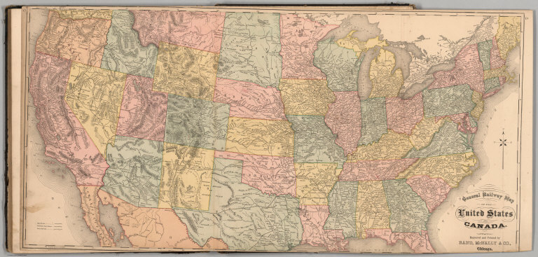
Higgins, Belden & Co.
Full Title
General Railway Map of the United States and Canada, Engraved and Printed by Rand, McNally & Co., Chicago.
List No
3739.092
Author
Kingman Brothers.
Full Title
New Railroad Map of the United States.
List No
3740.004
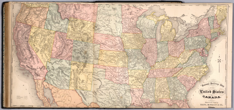
Author
Higgins, Belden & Co.
Full Title
General Railway Map of the United States and Canada. Engraved and Printed by Rand, McNally & Co., Chicago.
List No
3746.079
Note
Fold out. Relief shown by hachures.
Author
Titus, Clarence O.
Full Title
Outline & rail road map of the United States of America. Published by C.O. Titus, 320 Chestnut St., Philadelphia, Pa. (1869)
List No
3748.039
Note
Hand col. lithographed map. Relief shown by hachures. Shows states in full color, railroads, etc.
Author
[Lathrop, J.M., Penny, H.C., Proctor, W.R.]
Full Title
Gray's New Map of the United States by Frank A. Gray. (inset) Sketch Exhibiting the Westward Movement of the Centre of Population.
List No
3750.028
Author
Beers, D.G.
Full Title
Map of the United States 1874. (inset) Alaska.
List No
4487.005
Note
Relief shown in hachures.
Author
[Gray, Frank A., Lathrop, J.M., Penny, H.C., Proctor, W.R.]
Full Title
Gray's New Map of the United States By Frank A. Gray. Copyright 1879 by O.W. Gray & Son. Philadelphia, Gray & Son.
List No
4522.028
Author
[Howden, J.A., Odbert, A., Williams, W.W.]
Full Title
Map of the United States, and Territories together with Canada &c. (inset) Island of Newfoundland. Constructed & Engraved by W.Williams Philadelphia.
List No
4753.046
Note
Relief shown by hachures. Prime meridians Washington and Greenwich.
Author
Caldwell, Joseph A.
Full Title
United States of America by J.A. Caldwell.
List No
4974.032
Author
Caldwell, Joseph A.
Full Title
Map of the Pittsburg, Cincinnati and St. Louis R.R., Pan Handle Route and Principal Connections.
List No
4974.061
Author
Caldwell, Joseph A.
Full Title
United States of America, by J.A. Caldwell. Entered ...1872 by G.W. & C.B. Colton ... Washington. (to accompany) Caldwell's Illustrated, Historical, Centennial Atlas Of Beaver County, Pennsylvania. From actual Surveys by & under the directions of J.A. Caldwell. Assisted by C.T. Arms, Sr. C.E. J.A. Underwood, C.E. J.A. Howden. P.L. Mason. W.J. Kerstetter, C.E. W.F. Arms, C.E. J.J. Power, C.E. Published By J.A. Caldwell, Condit, Ohio. 1876. Engraved, Lithographed & Printed By Otto Krebs, Pittsburgh, Pa.
List No
5043.036
Note
Full color map. Relief shown by hachures. Prime meridians are Greenwich and Washington, D.C.
Author
George F. Cram Company
Full Title
Map of the United States.
List No
5166.069
Author
Rand McNally and Company
Full Title
Map of the United States. Rand, McNally & Co., Map Publishers and Engravers, Chicago. (1885)
List No
5747.017
Note
Color map. Relief shown by hachures. States in full color. Shows settlements, railroads, rivers, etc. Small inset maps: Vicinity of Philadelphia -- Plan of New York -- Plan of Washington, D.C. Prime meridians: Greenwich and Washington.
1-37 of 37
|