|
Author
Arrowsmith, John, 1790-1873
Full Title
Official map of railways in England and Scotland, shewing the existing lines & those in progress; from the maps prepared, by the authority of the Commissioners of Railways; (presented to both houses of parliament) and from the other documents; by John Arrowsmith. 1858. London, pubd. July 1st, 1858, by J. Arrowsmith, 10 Soho Square.
List No
14506.014
Note
Composite map of railways in England and Scotland. Shows counties, cities, railways, bodies of water, drainage, coastlines and islands. Relief shown with hachures. Includes a legend, latitudinal and longitudinal lines, as well as a bar scale given in English miles. Hand-colored engraving. Hand-colored engraving. All together, map is 106 x 67 cm, on two double sheets, together 68 x 112 cm.
Author
[Depot General de la Marine, MacKenzie, Murdoch]
Full Title
(Composite map of) Carte Des Rades De Ste Helene Et Spithead (and) Carte De Selsea-Bill
List No
15934.060
Note
Hydrographie Française 2
Author
Depot General de la Marine
Full Title
(Composite map of) (North and South Sheets) Carte Reduite De La Mer Du Nord.
List No
15934.006
Note
Hydrographie Française 1
Author
[Stockdale, John (1749-1814), Neele, Samuel John, 1758-1824]
Full Title
(Composite map of) I - XX Map Of England And Wales From The Latest Surveys.
List No
15800.023
Note
Dimensions are sheet sizes.
Author
[Weekly Dispatch, Weller, Edward, 1819-1884]
Full Title
(Composite Map to) England and Wales : North-west sheet -- South west sheet / by Edwd. Weller, F. R. G. S. ; engraved by Edwd. Weller, Duke Strt. Bloomsbury ; E. Weller Lithogr.
List No
14360.012
Note
Composite map of England and Wales (northwest and southwest sheets). Shows political boundaries, counties, cities, railways, canals, topography, bodies of water, drainage, coastlines, shoals and islands. Relief shown with contour lines. Includes latitudinal and longitudinal lines, as well as a legend and two bar scales, given in British statute and geographical miles. Hand-colored lithograph. Map is 84 x 66 cm, on two double sheets, together 138 x 96 cm. Sheets presented in sequence. Appears in Vol. I : British.
Author
Stieler, Adolf, 1775–1836
Full Title
(Composite to) Grossbritannien Im Maassstabe Von 1:1.500.000. Von A. Petermann. Bearb. v. Ernst Debes. Gest. v. Poppey u. Jungmann. Stieler's Hand-Atlas No. 46-47. Gotha: Justus Perthes 1875.
List No
13563.067
Note
1 map on 2 sheets. Outline color map of Great Britain. sheets 46-47.
Author
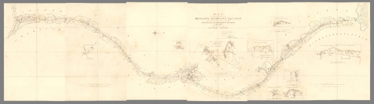
[Vignoles, Charles Blacker, Midland Counties Railway Company]
Full Title
(Composite map of) (Sheets 1-6) Map of that portion of the Midland Counties Railway extending from its junction with the London and Birmingham Railway at Rugby to the north side of the River Trent.
List No
10732.008
Note
Date estimated.
Author
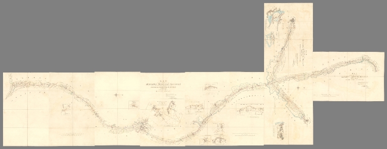
[Vignoles, Charles Blacker, Midland Counties Railway Company]
Full Title
(Composite map of) All Sheets Map of that portion of the Midland Counties Railway extending from its junction with the London and Birmingham Railway at Rugby to the north side of the River Trent (River Trent to Pinxton : Derby and Nottingham) ...
List No
10732.019
Note
Date estimated.
Author
Greenough, George Bellas, (1778-1855)
Full Title
(Composite map of) N.E.,N.W.,S.W.,S.E. Sheets. A Physical and Geological Map of England and Wales By G.B. Greenough Esq. F.R.S. (on the basis of the original Map of William Smith 1815) Revised and Improved under the Superintendence of a Committee of the Geological Society of London, from the maps of the Geological Survey of Great Britain, 1836-63 and the Maps and Documents contributed by Sir R. I. Murchison, Professor Phillips, Joseph Prestwich, R. Godwin Austen, and others. July 1865.
List No
10491.006
Note
Greenough first published this map in 1820, then a second edition in 1839 (see our 10496.000), and this final third posthumous edition in 1865. Greenough drew heavily on William Smith's Geological map of England and Wales but did not credit him until the third edition. There are several differences between the Greenough and Smith maps: Greenough delineates the topography and Smith does not, and Greenough's scale is 6 miles to the inch vs Smith at 5 miles to the inch. There were also differences underlying the geology of both maps. Greenough made significant revisions to the second edition and to this final third edition. Following the publication of the first 1820 edition, there was a continuing dispute between Greenough and Smith as to Greenough's uncredited use of Smith's map.
Author
Greenough, George Bellas, (1778-1855)
Full Title
(Composite map of) A Physical and Geological Map of England and Wales By G.B. Greenough Esq. President of the Geological Society of London. At its Establishment and at subsequent periods: President of the Royal Geographical Society of London &c. First Edition No. 1st 1819. Second Edition Novr. 1st 1839.
List No
10496.009
Note
Greenough first published this map in 1820, then this second edition in 1839, and a final third posthumous edition in 1865. Greenough drew heavily on William Smith's Geological map of England and Wales but did not credit him until the third edition. There are several differences between the Greenough and Smith maps: Greenough delineates the topography and Smith does not, and Greenough's scale is 6 miles to the inch vs Smith at 5 miles to the inch. There were also differences underlying the geology of both maps. Greenough made significant revisions to this second edition and to the final third edition. Following the publication of the first 1820 edition, there was a continuing dispute between Greenough and Smith as to Greenough's uncredited use of Smith's map. The N.E. sheet is from a different copy as is the Index of Colours which was both pasted on the map in some copies and issued separately in others - both are present here. Although it appears that the index of colors that is pasted onto the W. Sheet of this copy is an early version of the index of colors that appears on the 1865 third edition. It does not actually represent the colors used on the map so may have been added afterwards, incorrectly. The separate sheet Index of Colours is the correct index for colors in this second edition.
Author
Greenough, George Bellas, (1778-1855)
Full Title
(Composite map of) A Physical and Geological Map of England and Wales By G.B. Greenough Esq. President of the Geological Society of London. At its Establishment and at subsequent periods: President of the Royal Geographical Society of London &c. First Edition No. 1st 1819. Second Edition Novr. 1st 1839.
List No
10496.010
Note
Note: This composite image has added the original separately printed Index of Colours below the title on the E. Sheet. Greenough first published this map in 1820, then this second edition in 1839, and a final third posthumous edition in 1865. Greenough drew heavily on William Smith's Geological map of England and Wales but did not credit him until the third edition. There are several differences between the Greenough and Smith maps: Greenough delineates the topography and Smith does not, and Greenough's scale is 6 miles to the inch vs Smith at 5 miles to the inch. There were also differences underlying the geology of both maps. Greenough made significant revisions to this second edition and to the final third edition. Following the publication of the first 1820 edition, there was a continuing dispute between Greenough and Smith as to Greenough's uncredited use of Smith's map. The N.E. sheet is from a different copy as is the Index of Colours which was both pasted on the map in some copies and issued separately in others - both are present here. Although it appears that the index of colors that is pasted onto the W. Sheet of this copy is an early version of the index of colors that appears on the 1865 third edition. It does not actually represent the colors used on the map so may have been added afterwards, incorrectly. The separate sheet Index of Colours is the correct index for colors in this second edition.
Author
[Johnston, Alexander Keith, 1804-1871, Forbes, Edward]
Full Title
(Composite Map) Paleontological Map of the British Islands.
List No
12509.039
Author
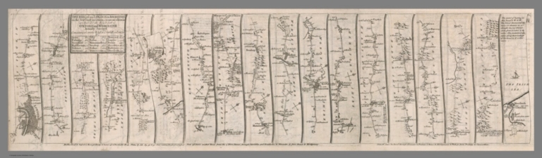
[Senex, John (1680-1740), Wilkinson, Robert, Ogilby, John (1600-1676)]
Full Title
(Composite map) The road from London to Aberistwith : on the sea coast com. Cardigan, wherein are included the roads to Oxford and Worcester, Actually surveyed. I. Senex Sculpt. (to accompany)The roads through England delineated, or, Ogilby's survey : revised, improved, and reduced to a size portable for the pocket by John Senex, F.R.S. ... Publish'd ... 1st May 1780, by R. Wilkinson ... Cornhill, London.
List No
2634.011
Note
Composite to sheets 1-3, road from London to Aberistwith.
Author
[Coronelli, Vincenzo (1650-1718), Accademia cosmografica degli Argonauti.]
Full Title
(Composite to) Parte meridionale del Regno D'Inghilterra. Parte settentrionale del regno d'Inghilterra. Descrutto, e dedicato dal P. Coronelli, cosgrafo della serenissima Republica di Venetia. All illustrissimo, et eccellentissimo signore Angelo Morosini, caualiere, e procuratore di S. Marco, etc. (to accompany) Isolario descrittione geografico-historica, sacro-profana, antico-moderna ... e in supplimento dei XIV volumi del Bleau. Tomo II dell' Atlante veneto. Opera, e Studio del P. Maestro Vincenzo Coronelli ... A Spese dell Auttore MDCLXXXXVI. (inset) Isole Britanich.
List No
11391.013
Note
Composite to sheets 2-3 and 6-7 of England.
Author
[Ordnance Survey Office, Great Britain, Ordnance Survey]
Full Title
(Composite map of) England and Wales, Sheets 1 - 146. Ordnance Survey, Popular Edition One-Inch Maps.
List No
7805.153
Note
Composite of all the sheets (1 - 146) of the Popular Edition maps of England and Wales. Date used is the year of publication of the facsimile source of the index map: Hodson, Yolande. 1999. Popular Maps, The Ordnance Survey Popular Edition One-Inch Map of England and Wales, 1919-1926. London: The Charles Close Society. We are grateful for the assistance of Christopher Fleet, Senior Map Curator at the National Library of Scotland, and his staff in the georeferencing of this map.
Author
[Great Britain. Ordnance Survey, Mudge, William (1762-1820), Colby, Thomas, Baker, Benjamin, Great Britain. Board of Ordnance]
Full Title
(Composite of) Devon Sheets 20 to 27 and title.
List No
6745.010
Note
Published Oct. 11, 1809, by Lt. Coll. Mudge, Tower. A composite image of all eight sheets of the Devon map, including the title sheet. State 1, Margary.
Author
Ordnance Survey Office
Full Title
England, Wales, (Composite 0f) Outline Sheets 1 - 360.
List No
6751.001
Note
A composite image of all outline sheets with contours in the Revised New Series. The Ordnance Survey One-inch Revised New Series, England and Wales, was published between 1892-1908, in both outline sheets with contours and hill shaded sheets. This set of 691 maps is owned by the National Library of Scotland (NLS). Scans and georeferenced images were generously provided to us in 2014 as part of a joint project under the guidance of Christopher Fleet, Senior Map Curator at the NLS. A few sheets of the set are from the 3rd edition of the one inch maps, published in the early 1900's. For more detailed information on the Revised New Series, see the excellent summaries and map presentations on the NLS website, http://maps.nls.uk/os/one-inch-rev-new-series/index.html
Author
Ordnance Survey Office
Full Title
England, Wales, (Composite 0f) Hill Sheets 1 - 360.
List No
6751.002
Note
A composite image of all hill sheets in the Revised New Series. 4 hill sheets were missing from this set and we have substituted the corresponding outline sheets to fill in the composite. The Ordnance Survey One-inch Revised New Series, England and Wales, was published between 1892-1908, in both outline sheets with contours and hill shaded sheets. This set of 691 maps is owned by the National Library of Scotland (NLS). Scans and georeferenced images were generously provided to us in 2014 as part of a joint project under the guidance of Christopher Fleet, Senior Map Curator at the NLS. A few sheets of the set are from the 3rd edition of the one inch maps, published in the early 1900's. For more detailed information on the Revised New Series, see the excellent summaries and map presentations on the NLS website, http://maps.nls.uk/os/one-inch-rev-new-series/index.html
Author
Ordnance Survey Office
Full Title
(Composite of) London 753 Sheets.
List No
6752.001
Note
A composite image of 753 of 759 sheets in the London, Five feet to the Mile set. The Ordnance Survey London, Five feet to the Mile maps were published between 1893-1896, using a process pioneered by the Ordnance Survey called photozincography, a form of lithography. This set of 753 maps is owned by the National Library of Scotland (NLS). Scans and georeferenced images were generously provided to us in 2014 as part of a joint project under the guidance of Christopher Fleet, Senior Map Curator at the NLS. A few sheets of the set are from the 3rd edition of the one inch maps, published in the early 1900's. For more detailed information on the London, Five feet to the Mile maps, see the excellent summaries and map presentations on the NLS website, http://maps.nls.uk/os/london-1890s/index.html
Author
Great Britain. Ordnance Survey
Full Title
(Composite Map of) England and Wales, New Popular One-Inch Map, Sheets 64-190 (114 sheets).
List No
6917.120
Note
This composite map of all 114 sheets of the New Popular edition Ordnance Survey Maps of England and Wales was generously provided to us by the National Library of Scotland, Christopher Fleet, Senior Map Curator. For more information on this composite map see the NLS website, http://maps.nls.uk/os/one-inch-new-popular/index.html
Author
[Ordnance Survey Office, Geikie, Archibald]
Full Title
(Composite of) Sheets 2 - 15. Ordnance Survey of England and Wales.
List No
8742.017
Author
Cary, John, ca. 1754-1835
Full Title
(Composite of) (Cary's New Map of England And Wales, With Part Of Scotland).
List No
0132.045
Note
Relief shown by hachures. Parks, canals, roads, churches, and towns (by class) shown.
Author
Johnston, Alexander Keith, 1804-1871
Full Title
(Composite of) England and Wales by Keith Johnston, F.R.S.E. Engraved & printed by W. & A.K. Johnston, Edinburgh. William Blackwood & Sons, Edinburgh & London, (1861)
List No
0373.007
Note
Two engraved maps. County boundaries hand col.; hydrography, shipping lanes printed in blue. Relief shown by hachures. Covers also the Channel Islands. Inset map: Scilly Islands and Lands End. "Keith Johnston's general atlas" 5-6.
Author
Johnston, Alexander Keith
Full Title
(Composite) England and Wales. By Keith Johnston, F.R.S.E. Keith Johnston's General Atlas. Engraved, Printed, and Published by W. & A.K. Johnston, Edinburgh & London.
List No
0377.008
Note
Counties outlined in color. Relief shown by hachures.
Author
Kitchin, Thomas
Full Title
A compleat map of the British Isles, or Great Britain and Ireland with their respective roads and divisions. (By Thomas Kitchin). London: published by Robt. Sayer, no. 53 Fleet Street, as the Act directs, 1st Jany. 1788.
List No
0411.007
Note
Engraved map with counties in outline color. Relief shown pictorially. (W 12--E 2/N 61--N 49)
Author
Rocque, John
Full Title
(Composite of) England and Wales, drawn from the most accurate surveys containing all the cities, boroughs, market towns & villages; in which are included all the improvements and observations both astronomical and topographical, which have been made by members of the Royal Society & others. Down to the present year, the whole corected & improv'd by John Rocque, Chorographer to his Majesty. London, printed for Robt. Sayer, Map & Printseller at the Golden Buck in Fleet Street, (1790?)
List No
0411.010
Note
Engraved map printed on 4 sheets comprising. Counties in outline color. Shows forested areas, classified roads with distances, etc. Relief shown pictorially. Includes inset map of the Isles of Scilly and drawings of ships. David Rumsey Collection sheets mounted together as 2 sheets. (W 7 00--E 2 30/N 56 20--N 49 30)
Author
Lizars, Daniel
Full Title
(Composite of) England. Published by D. Lizars, Edinburgh. (1831?)
List No
0436.010
Note
Digital composite of 2 sheets. Hand colored engraved map. Relief shown by hachures. Shows settlements, counties, roads, etc. South sheet has title: Southern part of England.
Author
Lizars, William Home, 1788-1859
Full Title
(Composite map) England. Published by W.H. Lizars, Edinburgh. With all the railways. Samuel Highley, London & W. Curry junr. & Co, Dublin. (to accompany) Lizars' Edinburgh Geographical General Atlas ... 1841.
List No
0438.017
Note
Digital composite of sheets X-XI, 1 map on 2 sheet, double page engraved hand colored in outline.
Author
Pinkerton, John, 1758-1826
Full Title
(Composite of) England ... Drawn under the direction of Mr. Pinkerton by L. Hebert. Neele sculpt. 352 Strand. London: published ... 1811 by Cadell & Davies, Strand, & Longman, Hurst, Rees, Orme, & Brown, Pater-Noster Row.
List No
0732.009
Note
Engraved map on 2 sheets (southern part, northern part). Full hand col. Relief shown by hachures. "Pinkerton's modern atlas."
Author
Stanford, Edward
Full Title
(Composite of) England and Wales.
List No
0949.028
Note
Digital composite of 4 sheets. Counties in full color. Relief shown by hachures and spot heights. Shows municipal boroughs, settlements, railroad, etc.
Author
[Stieler, Adolf, Koffmahn, O.]
Full Title
(Composite Map) 37-38. Grossbritannien Suedl. Bl.
List No
0961.088
Author
[Stieler, Adolf, Koffmahn, O.]
Full Title
(Composite Map) Nr. 38. Groszbritannien. ... von O. Koffmahn.
List No
0962.088
Author
[Vignoles, Charles Blacker, Midland Counties Railway Company]
Full Title
(Sheet 1) Map of that portion of the Midland Counties Railway extending from the River Trent to Pinxton.
List No
10732.011
Note
Date estimated.
Author
[Vignoles, Charles Blacker, Midland Counties Railway Company]
Full Title
(Sheet 2) Map of that portion of the Midland Counties Railway extending between Derby and Nottingham.
List No
10732.016
Note
Date estimated.
Author
Society for the Diffusion of Useful Knowledge (Great Britain)
Full Title
(Composite map of) England and Wales. No.1- 6.
List No
10911.019
Author
[Arrowsmith, John, 1790-1873, Stanford, Edward, 1827-1904]
Full Title
(Composite map) England and Wales. London: Edward Stanford, 55 Charing Cross, S.W. Stanford's Geographical Establishment. (to accompany) Stanford's London Atlas Of Universal Geography. Folio edition.
List No
11741.008
Note
Composite map of sheets 8-11 of England and Wales.
Author
[Stieler, Adolf, Haack, H.]
Full Title
(Composite Map) 36-37. Schottland und England.
List No
12248.083
Author
[Schraembl, Franz Anton, Kitchin, Thomas]
Full Title
(Composite Map) 35-38. Karte von England und Wallis. Neu entworfen und nach astronomi schen Beobachtungen verbessertMit der Anzeige der Orte, wo sie gemacht worden von Herrn Thomas Kitchin herausgegeben von Herrn F.A. Schraembl. MDCCLXXXVII.
List No
12498.060
Author
Cassini, Gio. Ma. (Giovanni Maria), 1745-approximately 1824
Full Title
(Composite to) La parte meridionale dell'Inghilterra e del principato di Galles delineata sulle ultime osservazioni ... -- La parte settentrionale dell'Inghilterra e del principato di Galles delineata sulle ultime osservazioni. Roma, presso la Calcografia Camerale, 1795.
List No
14000.145
Note
Composite to maps 49 and 50 (as numbered in index) in Volume II. Includes decorative title cartouche on each of the two sheets: meridionale and settentrionale.
Author
Stanford, Edward, 1827-1904
Full Title
(Composite map of) 15 - 18. England (and Wales). London: Edward Stanford, 55 Charing Cross, S.W.
List No
14053.075
Note
Composite of four sheets of Map of England and Wales - in colored lithograph. Shows political boundaries, railways, topography and drainage. Relief illustrated by hachures. Includes a legend, as well as a bar scale. With inset: The Scilly Islands. Each map 56 x 46 cm, on sheets 71 x 55 cm. In Vol. II.
Author
Philip, George, 1870-1937.
Full Title
(Composite map to) England and Wales.
List No
15487.014
Author
Bartholomew, John
Full Title
(Composite of) Plates 56, 57, 58, 59, England South and Wales, Midlands and Scottish Borders, Scotland North, Ireland, V. III
List No
1552.310
Note
Composite map of plates 56, 57, 58, and 59.
Author
Blackie, W.G.
Full Title
(Composite Map) England & Wales.
List No
1589.021
Author
[Bartholomew, J. G. (John George), 1860-1920, John Bartholomew & Co.]
Full Title
(Composite of) Section maps of the British Isles on a scale of 1:633,600. The Edinburgh Geographical Institute, John Bartholomew & Co. "The Times" atlas. (London: The Times, 1922)
List No
2113.026
Note
Composite of seven col. maps. Relief shown by hypsometric tints; depths by bathymetric tints. Shows shipping routes with distances, etc. Includes insets. Title from versos.
Author
[Lowry, J.W., Sharpe, J.]
Full Title
(Composite of) Sharpe's Corresponding Maps. England and Wales Railway Map. Engraved by J. Wilson Lowry. London - Published by Chapman and Hall, 186 Strand -1847. Enlarged Series.
List No
2175.008
Note
Has little foldout tab for Lands End at southwest tip of Cornwall. Relief shown by hachures. Countries and counties outlined in color. Railroads in blue.
Author
[Black, Adam & Charles, Hall, Sidney, Hughes, William]
Full Title
(Composite of) England and Wales. Edinburgh. Published by A. & C. Black. Engraved by S. Hall, Bury Strt. Bloombry.
List No
2305.015
Note
Relief shown by hachures. Counties tinted.
Author
[Kitchin, Thomas, Phillips, J., Robert Laurie & James Whittle]
Full Title
(Composite of) A new map of England & Wales. Drawn from several surveys &c. on the new projection : corrected from astronomical observations & the places marked where the observatns. were made. By Thos. Kitchin, Geogr. The canals inserted to 1792 by J. Phillips, Surveyor. London, Published by Laurie & Whittle, No. 53, Fleet Street, as the act directs, 12th May, 1794.
List No
2310.011
Note
Digital composite of 2 hand colored engraved maps. Relief shown pictorially. Shows counties, settlements, roads with distances to London, finished and unfinished canals, rivers intended to be made navigable, etc. Has illustrated cartouche, table "The inland navigations in England &c." and inset of the Isles of Scilly. Printed on 4 sheets; joined as 2.
Author
[Stieler, Adolf, Stulpnagel, F.v.]
Full Title
(Composite of) No. XVII, XIX, XX. Stieler's Hand-Atlas (No. 15b, 15c, 15d.) England und Wales, Schotland, Ireland.
List No
2507.126
Note
Revision of 1841 edition.
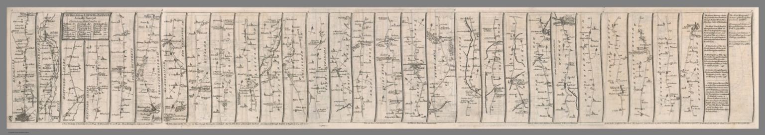
Author
[Senex, John (1680-1740), Wilkinson, Robert, Ogilby, John (1600-1676)]
Full Title
(Composite map) The road from London to Barwick, Actually surveyed. I. Senex Sculpt. (to accompany)The roads through England delineated, or, Ogilby's survey : revised, improved, and reduced to a size portable for the pocket by John Senex, F.R.S. ... Publish'd ... 1st May 1780, by R. Wilkinson ... Cornhill, London.
List No
2634.016
Note
Composite map, sheets 5-9.
Author
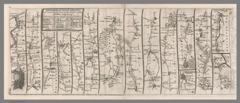
[Senex, John (1680-1740), Wilkinson, Robert, Ogilby, John (1600-1676)]
Full Title
(Composite map) The road from London to Bristol : and continued from thence to huntspil in Somersetshire, Actually surveyed. I. Senex Sculpt. (to accompany)The roads through England delineated, or, Ogilby's survey : revised, improved, and reduced to a size portable for the pocket by John Senex, F.R.S. ... Publish'd ... 1st May 1780, by R. Wilkinson ... Cornhill, London.
List No
2634.019
Note
Composite map, sheets 10-11.
|