|
REFINE
Browse All : Composite Map of California
1-23 of 23
Author
Cram, George Franklin, 1841-1928
Full Title
(Composite Map to) California and Nevada : Northern half. -- California and Nevada : Southern half. 1899, by Geo. F. Cram.
List No
14372.205
Note
Composite map of California and Nevada (northern and southern halves). Shows political boundaries, counties, towns, railroads, topography, bodies of water, drainage, coastlines and islands. Relief shown with hachures. Includes keys with explanations, latitudinal and longitudinal lines, as well as bar scales given in miles. With alphanumeric grid corresponding to "Index of Nevada" on page 371; "Index of California" on pages 374-375, 378-379 and 382. Colored lithograph. Together, maps are 82 x 57 cm, on two double sheets 90 x 67 cm. "Index of maps" and "Index of cities" in margins, providing navigation for atlas as a whole.
Author
Jenkins, Olaf P.
Full Title
(Composite map of) Sections I-VI. Geologic Map of California Prepared by Olaf P. Jenkins Chief Geologist, Geologic Branch
List No
15485.007
Note
Dimensions are sheet size.
Author
[Heald-Menerey Company, Inc., Heald, Ralph P.]
Full Title
(Composite map of) Heald-Menerey's Geographical, Commercial and Recreational Map of CaliforniaHeald-Menerey's Geographical, Commercial and Recreational Map of California
List No
15251.013
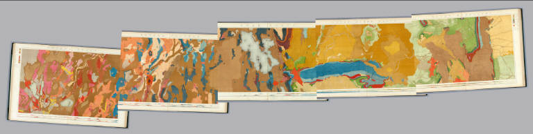
Author
California Division of Mines and Geology
Full Title
(Composite Map) Geologic Map of California.
List No
6347.114
Note
Full color. Olaf P. Jenkins Edition. Individual sheets dated 1958-1969.
Author
Raymo, Chet
Full Title
(Composite). A geologic and topographic profile of the United States along interstate 80 : by Chet Raymo. 1982. Printed by Hubbard, Northbrook, IL.
List No
13323.014
Note
Composite of 8 sheets of geologic cross section and topographic map. Covers the route along Interstate 80 from San Francisco to New York City.
Author
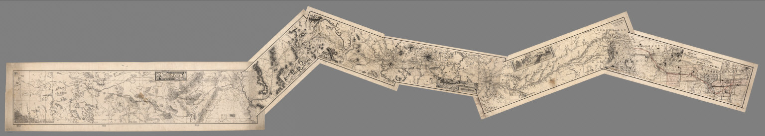
[California Geological Survey, Hoffmann, Charles F., Whitney, J.D.]
Full Title
(Composite) Topographical Map of Central California Together With a Part of Nevada. (Sheets I, II, III & IV). State Geological Survey Of California. J.D. Whitney, State Geologist. C.F. Hoffmann, Principal Topographer, V. Wackenreuder, J.T. Gardner, A. Craven, A.D. Wilson, Field Assistants. 1873 ... Julius Bien, Engr.
List No
2546.006
Note
Four sheets. South 2 sheets of 4; top 2 sheets apparently were never issued but were printed. Four unmounted sheets on heavy paper. Never folded.
Author
Atlantic & Pacific Railroad
Full Title
(Composite of) Maps of the First through Sixth Operating Divisions of the Western Division, Atlantic & Pacific Railroad, Albuquerque, New Mexico, to Mojave (Mohave), California.
List No
6929.007
Note
Composite of all six maps joined together end to end. This is a set of six hand-drawn maps on semi-transparent waxed linen with some color. Some areas are colored on the verso to highlight the areas in a muted style. We think that some type of backlighting was planned to be used to create a photolithographic plate from which printing would be done. No evidence was found that it was ever printed. These sheets were deaccessioned from the Santa Fe Railroad collection in the 1980s. Lewis Kingman did the route survey from Albuquerque to Needles. Relief shown by hachures.
Author
Asher & Adams
Full Title
(Composite of) Asher & Adams' California & Nevada. Entered according to Act of Congress in the year 1874 by Asher & Adams ... at Washington. (New York, 1874)
List No
0041.030
Note
Composite of 2 sheets: South portion -- North portion. Hand col. engraved map. Relief shown by hachures and spot heights. Shows townships, distances along railroads, etc. Prime meridians: Greenwich and Washington.
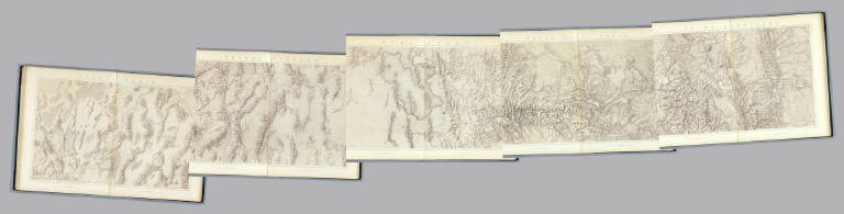
Author
King, Clarence
Full Title
(Composite of) Geological Maps I-V, 40th Parallel Survey.
List No
0408.007
Note
Maps in full color with the legends on either side of the maps.
Author
King, Clarence
Full Title
(Composite of) Topographical Maps I-V, 40th Parallel Survey.
List No
0408.014
Note
Maps in brown shaded relief.
Author
U.S. General Land Office
Full Title
Department of the Interior, General Land Office. S.S. Burdett, Commissioner. State of California. 1876. Compiled from the official records of the General Land Office and other sources by C. Roeser, Principal Draughtsman G.L.O. Photolith. & Print by Julius Bien 16 & 18 Park Place, N.Y.
List No
11179.020
Note
Color map on 2 sheets. Includes references and list of surveyed private grants. Relief shown by hachures.
Author
Nirenstein, Nathan
Full Title
(Composite map of) State of California, North Half and South Half. (Built-up Areas).
List No
12506.056
Note
Date estimated. Intended to show built-up areas of towns and cities of over 20,000 population, but not done.
Author
De Pue & Company
Full Title
(Composite of) Official map of Yolo County, California. De Pue & Company, publishers & compilers, Oakland, Cal. Lith. W.T. Galloway, S.F. 1879.
List No
2146.008
Note
Hand col. lithographed map on 6 sheets. Also issued as separate. Shows political townships, township and section lines, land ownership, drainage, railroads, etc. Includes insets showing parts of sections. "Adopted by the Board of Supervisors, November 6th, 1879."
Author
[California Geological Survey, Hoffmann, Charles F., Whitney, J.D.]
Full Title
(Composite) Topographical Map of Central California Together With a Part of Nevada. (Sheets III & IV). State Geological Survey Of California. J.D. Whitney, State Geologist. C.F. Hoffmann, Principal Topographer, V. Wackenreuder, J.T. Gardner, A. Craven, A.D. Wilson, Field Assistants. 1873 ... Julius Bien, Engr.
List No
2546.005
Note
South 2 sheets of 4; top 2 sheets apparently were never issued but were printed. See Pub Note.
Author
Rand McNally and Company
Full Title
(Composite Map) California. (insets) San Francisco and Vicinity. Los Angeles and Vicinity. San Diego and Vicinity.
List No
2790.264
Author
Cram, George Franklin
Full Title
(Composite of) California and Nevada.
List No
2809.059
Note
Locations of banking towns shown by red circles. Railroads are indicated by numbers and colors and patterns, and each railroad has the same number and color and pattern in every state through which it passes. All railroads on each map are in a list keyed to the map. Border of map has a table of contents for the atlas. Relief shown by hachures. Prime meridians Washington D.C. and Greenwich.
Author
[United States. Post Office Department, Von Haake, A.]
Full Title
(Composite of) Post route map of the states of California and Nevada showing post offices with the intermediate distances and mail routes in operation on the 1st of June, 1896. Published by order of Postmaster General William L. Wilson under the direction of A. von Haake, Topographer, P.O. Dept. (Washington, D.C., 1896)
List No
3356.003
Note
Composite of four col. sheets folded in 2 covers. Shows drainage, counties, railroads, etc. Inset maps: (San Francisco Bay Area). Scale (ca. 1:450,000) -- (Los Angeles and vicinity). Scale (ca. 1:450,000). Includes lists of counties in California & Nevada.
Author
[Arrowsmith, Aaron, Humboldt, Alexander von, 1769-1859]
Full Title
(Composite of) A new map of Mexico and adjacent provinces compiled from original documents by A. Arrowsmith, 1810. (with) Valley of Mexico, from Mr. Humboldt's map. (with) Veracruz. (with) Acapulco. London, Published 5th October 1810 by A. Arrowsmith, 10 Soho Square, Hydrographer to H.R.H. the Prince of Wales. Engraved by E. Jones.
List No
5699.014
Note
Engraved map on 4 sheets. Outline hand col. Relief shown by hachures. Shows settlements, roads, Indian tribes, rivers, etc. Scale of Valley of Mexico inset (ca. 1:363,000)
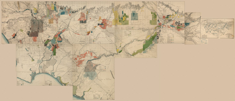
Author
[Hall, Wm. Ham. (William Hammond), California Department of Engineering]
Full Title
(Composite of) California State Engineering Department. Detail Irrigation Map(s), Los Angeles and San Bernardino Counties, California. To Accompany Report on Irrigation and Water Supply. Wm. Ham. Hall, State Engineer, 1888. George Sandow, Draughtsman.Wm. Ham. Hall, State Engineer. Irrigation Data 1888. Scale 1 1/2 Inches to One Mile.
List No
5830.013
Note
In color.
Author
[Hall, Wm. Ham. (William Hammond), California State Engineering Department]
Full Title
(Composite of) California State Engineering Department. Topographical And Irrigation Map Of The San Joaquin Valley. (Sheets Nos. 1-4). Wm. Ham. Hall, State Engineer, 1886. Note. This Topographical and Irrigation Map of San Joaquin Valley is published in four sheets, as follows: Sheet No. 1, from Tp. 4 N. to 1st Standard South. Sheet No. 2, from 1st to 3d Standard South. Sheet No. 3, from 3d to 5th Standard South. Sheet No. 4, from 5th to 8th Standard South. It is intended as a general illustration of the present extent of irrigation, and a means of studying its future possible development ...
List No
5833.005
Note
Composite of the four sheets covering the entire San Joaquiin Valley.
Author
United States. Post Office Department
Full Title
(Composite Map) Post Route Map of the States of California and Nevada Showing Post Offices with the Intermediate Distances on Mail Route ... January 15, 1960.
List No
9220.003
Author
United States. Post Office Department
Full Title
(Composite Map) Post Route Map of the States of California and Nevada Showing Post Offices with the Intermediate Distances on Mail Route ... March 1, 1952. (insets) San Francisco & Vicinity. Los Angeles & Vicinity. San Diego & Vicinity.
List No
9364.003
Author
United States. Post Office Department
Full Title
(Composite Map) Post Route Map of the States of California and Nevada Showing Post Offices with the Intermediate Distances on Mail Route ... June 15, 1954. (insets) San Francisco & Vicinity. Los Angeles & Vicinity. San Diego & Vicinity.
List No
9659.003
Note
Marked up.
1-23 of 23
|