|
REFINE
Browse All : Composite Map from 1882
1-21 of 21
Author
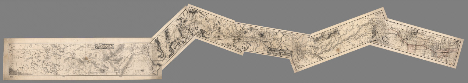
Atlantic & Pacific Railroad
Full Title
(Composite of) Maps of the First through Sixth Operating Divisions of the Western Division, Atlantic & Pacific Railroad, Albuquerque, New Mexico, to Mojave (Mohave), California.
List No
6929.007
Note
Composite of all six maps joined together end to end. This is a set of six hand-drawn maps on semi-transparent waxed linen with some color. Some areas are colored on the verso to highlight the areas in a muted style. We think that some type of backlighting was planned to be used to create a photolithographic plate from which printing would be done. No evidence was found that it was ever printed. These sheets were deaccessioned from the Santa Fe Railroad collection in the 1980s. Lewis Kingman did the route survey from Albuquerque to Needles. Relief shown by hachures.
Author
[Conder, C.R. (Claude Reignier), Kitchener, H.R. (Horatio Herbert)]
Full Title
(Composite of) Map of Western Palestine in 26 Sheets from Surveys Conducted for The Committee of the Palestine Exploration Fund by Lieutenants C.R. Cronder and H.H. Kitchener, R.E. (Royal Engineers) during the years 1872-1877. Scale: One Inch to a Mile=1/63,360. Photozincographed for the Committee under the Superintendence of Lt. Coll. Carey, R.E. at the Ordnance Survey Office, Southampton, Colonel Cooke, C.B., R.E., Director, by Permission of the First Commissioner of H.M. Works. London. 1880.
List No
6930.030
Note
Mapped areas shown only; top left title block as shown on smaller (1:168,960) wall map versions not included; see title page above for the missing information.
Author
Stanford, Edward, 1827-1904
Full Title
(Composite map of) 22 and 23 Turkestan. London, Edward Stanford, 55, Charing Cross.
List No
14081.052
Note
Steel-engraved map, in color, of western and eastern Turkestan. Relief illustrated with hachures. Shows political boundaries, topography, drainage and submarine telegraph cables. Includes three bar scales. With latitudinal and longitudinal lines.
Author
Stanford, Edward, 1827-1904
Full Title
(Composte Map of) 35 and 36. A map of the provinces of Ontario, Quebec, New Brunswick, Nova Scotia and Prince Edward Island, in the dominion of Canada (east and west). London: Edward Stanford, 55, Charing Cross. Stanford's Geogl. Estabt. London.
List No
14081.053
Note
Steel-engraved map, in color, of eastern and western Canada. Relief illustrated with hachures. Shows political boundaries, railways, topography, drainage and submarine telegraph cables. Includes a legend and a bar scale. With latitudinal and longitudinal lines.
Author
Blackie, W.G.
Full Title
(Composite Map) England & Wales.
List No
1589.021
Author
Blackie, W.G.
Full Title
(Composite Map) Scotland.
List No
1589.024
Author
Blackie, W.G.
Full Title
(Composite Map) Ireland.
List No
1589.027
Author
Blackie, W.G.
Full Title
(Composite Map) Russia in Europe.
List No
1589.042
Author
Blackie, W.G.
Full Title
(Composite Map) India.
List No
1589.055
Author
Blackie, W.G.
Full Title
(Composite Map) The United States of North America. Atlantic States and Valley of the Mississippi.
List No
1589.074
Author
Smith, J.L.
Full Title
(Composite of) Driving Map of Philadelphia and Vicinity. Published by J.L. Smith, 27 South Sixth St. Phila., Pa. 1882. Entered ... 1882 by J.L. Smith ... Washington.
List No
2459.003
Note
Full color map. Folded into brown cloth covers 15.5x10.5 with "Smith's Map of Philadelphia And Vicinity" stamped in gilt.
Author
Stieler, Adolf
Full Title
(Composite of) Stieler's Hand-Atlas No. 27, 28. C. Vogel: Osterreich_Ungarn.
List No
2761.117
Author
[Page, H.R. & Co., Brewster, Charles]
Full Title
(Composite of) Map of Nebraska. Compiled from Official Records in the Surveyor General's Office And Other Authentic Sources By Charles Brewster C.E. Published by H.R. Page & Co. Chicago, Ill. 1882. Copyright 1879 by H.R. Page & Co.
List No
4421.003
Note
First edition was 1879. Large impressive sectional map of the State in two separate sheets. Two huge counties, Sioux and Cheyenne, cover the westernmost portion of the state at the Wyoming border. Another unnamed county dominates the upper middle section. The sectional surveys are completed throughout, except for the northwest corner. There was an earlier edition in 1880. Full color. Folded in textured black cloth covers 17x11 with "Sectional Map Of Nebraska H.R. Page & Co. Chicago." stamped in gold.
Author
Dutton, Clarence E. (Clarence Edward), 1841-1912
Full Title
(Composite) Map Of The Uinkaret Plateau. North and South Half. Atlas Sheets VII and VIII. Geology by C.E. Dutton. Julius Bien & Co. lith. U.S. Geological Survey, Geology of the Grand Canon District.
List No
4713.008
Note
In full color. Composite map of sheets VII and VIII.
Author
Dutton, Clarence E. (Clarence Edward), 1841-1912
Full Title
(Composite) Geologic Map Of The Southern Part Of The Kaibab Plateau. [Parts I-IV.] Atlas Sheets XI-XIV. Geology by C.E. Dutton. Julius Bien & Co. lith. U.S. Geological Survey, Geology of the Grand Canon District.
List No
4713.015
Note
In full color. Composite of all sections using Atlas Sheets 11-14.
Author
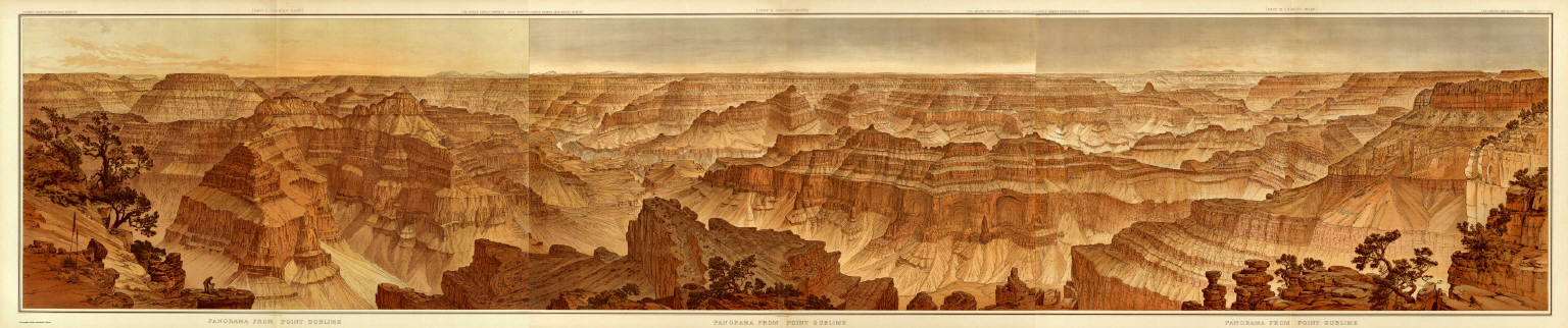
[Dutton, Clarence E. (Clarence Edward), 1841-1912, Holmes, William Henry, 1846-1933]
Full Title
(Composite) Panorama From Point Sublime. [Parts I-III.] W.H. Holmes. Atlas Sheets XV-XVII. Julius Bien & Co. lith. U.S. Geological Survey, Geology of the Grand Canon District.
List No
4713.019
Note
In full color. Composite of all sections using Atlas Sheets 15-17.
Author
Dutton, Clarence E. (Clarence Edward), 1841-1912
Full Title
(Composite) Geologic Map Sheets XX-XXIII. Geology by C.E. Dutton. Julius Bien & Co. lith. U.S. Geological Survey, Geology of the Grand Canon District.
List No
4713.026
Note
Composite map consists of four sheets although it was originally intended to have six. A note in the index states that "although much material has been obtained for their construction, much more is still required. No attempt to supply the defect has, therefore, been made in the present work." In full color.
Author
[Conder, C.R. (Claude Reignier), Kitchener, H.R. (Horatio Herbert)]
Full Title
(Composite). Map of Western Palestine from Surveys Conducted for The Committee of the Palestine Exploration Fund ... Special Edition Illustrating The Old Testament, The Apocrypha and Josephus ... by Trelawney Saunders. Scale 3/8 inch to one mile of 1:168,960.
List No
6930.037
Author
[Conder, C.R. (Claude Reignier), Kitchener, H.R. (Horatio Herbert)]
Full Title
(Composite). Map of Western Palestine from Surveys Conducted for The Committee of the Palestine Exploration Fund ... Special Edition Illustrating The New Testament, also The Talmud and Josephus ... by Trelawney Saunders. Scale 3/8 inch to one mile of 1:168,960.
List No
6930.044
Author
[Conder, C.R. (Claude Reignier), Kitchener, H.R. (Horatio Herbert)]
Full Title
(Composite). Map of Western Palestine from Surveys Conducted for The Committee of the Palestine Exploration Fund ... Reduced from the One-Inch Map. Scale 3/8 inch to one mile or 1:168,960.
List No
6930.051
Author
[Conder, C.R. (Claude Reignier), Kitchener, H.R. (Horatio Herbert)]
Full Title
(Composite). Map of Western Palestine from Surveys Conducted for The Committee of the Palestine Exploration Fund ... Reduced from the One-Inch Map ... Special Edition Illustrating the Divisions of the Natural Drainage and the Mountain Ranges According to "An Introduction to the Survey of Western Palestine by Trelawney Saunders.
List No
6930.058
Note
Includes cross-sections.
1-21 of 21
|