|
REFINE
Browse All : Communications of United States
1-31 of 31
Author
[General Drafting Company, Inc., New Jersey Bell Telephone Company]
Full Title
Visit Faraway Friends Tonight - by Low Cost Long Distance.
List No
12399.001
Note
Date estimated. This issue of this map includes the network of telephone lines covering the U.S.
Author
Colton, G.W.
Full Title
Colton's United States of America. Published By J. H. Colton. No. 172 William St. New York.
List No
0151.022
Note
Prime meridians are Greenwich and Washington D. C. Relief shown by hachures.
Author
KLZ Broadcasting Station
Full Title
Radio map of these United States. Showing KLZ and affiliated Columbia stations. Presented with the complement of KLZ Broadcasting Station, Denver, Col. Offices and studios in the Shirley Savoy Hotel. "Pioneer Broadcasting Station of the West."
List No
11085.000
Note
Promotional black and white pictorial map by the KLZ Broadcasting Station, Denver Colorado. Date estimated. Includes humorous pictographs representing different areas of the U.S. Shows state boundaries, major cities, railroads, industrial areas. Includes compass rose oriented with the north to upper margin. Relief shown pictorially. Note on the bottom right corner indicates the map should be returned to Mrs. Franklin. There are 2 dates hand-written on the back: 1919 and 1921. KLZ started broadcasting as KLZ in 1922, so the dates have little to do with the date it was printed.
Author
American Telephone and Telegraph Company. Long Lines Department.
Full Title
Overseas radio telephone service from the United States : direct and principal inter-connecting services - present and planned. Feb. 1, 1946. American Telephone & Telegraph Company, Long lines Department. Mercator projection. Based upon U.S. Hydrographic Office Map No. 5192. 7th edition. August 1931.
List No
11941.000
Note
Map of the world depicts the overseas American telephone and telegraph international radio telephone service as of February 1, 1946. Including existing and planned services from facilities in New York, Miami, San Francisco and Seattle with dozens of cities worldwide. Showing existing service indicated by solid lines and plans for the expansion of its international radio telephone system by dashed lines. New radiotelephone circuits were established to connect the United States with Barbados, Egypt, France, Germany, Japan, Netherlands, New Zealand, Norway, and the Philippine Islands. Note: "Service with Alaska is furnished over radio facilities of the U.S. Army Communication system Inter.Connected with Bell system wire facilities at Seattle." There was no direct radiotelephone circuit with Barbados, Egypt, New Zealand, and Norway prior to the war. New circuits were authorized between Puerto Rico and the Netherlands West Indies, and between the United States and Austria.
Author
Punnett Brothers
Full Title
A Radio Map of the Columbia Broadcasting System - Showing CBS Stations in the United States and Canada.
List No
12079.000
Note
Date based on penciled date on back.
Author
[General Drafting Company, Inc., New Jersey Bell Telephone Company]
Full Title
A Pictorial Map of the United States of America, Showing Principal Regional Resources, Products, and Natural Features. (insets) Pictorial Guide to New Jersey. Truck Line Railroads. Air Routes and Terrain. Telephone Lines.
List No
12399.002
Note
Date estimated. Contains hundreds of illustrations in color. This issue of this map includes the network of telephone lines covering the U.S.
Author
[3, Soviet Union. Glavnoe upravlenie geodezii i kartografii]
Full Title
Пути Сообщения Северной Америки = Puti Soobshcheniia Severnoy Ameriki. 211. Atlas Mira : 1954.
List No
13682.224
Note
Communication map of North America. Showing air routes, shipping and exploration routes, distances, principal railways, waterways and canals.
Author
[Geological Survey (U.S.), U.S. Census Bureau, United States. Bureau of Public Roads]
Full Title
Employment in transportation, communications, and utilities : 1960 / compiled from U. S. Bureau of the Census, Census of population: 1960, PC(1)-1C through 53C, Washington, U. S. Govt. Print Off., 1962, table 75 -- Average daily traffic flow, on the interstate system : 1967 / compiled from U. S. Bureau of Public Roads, "The National system of interstate and defense highways; 1967 average daily traffic on rural mileage of the travelled-way ... Dec. 1967," Travelled way traffic map: 1967, Washington, U. S. Govt. Print Off., map approx. 1:10,000,000.
List No
14359.172
Note
Two transportation maps representing the United States, featuring the geographic locations of employment in transportation, communications, and utilities, as of 1960, as well as average daily traffic on the interstate system, as of 1967. Maps also show political boundaries, bodies of water, coastlines and islands. Maps include legends, as well as bar scales and scale statements. Presented with Albers Equal Area Projection. With two inset maps within each map: Principal islands of Hawaii -- Alaska. Colored lithograph. Maps are each 20 x 31 cm, on sheet 49 x 35 cm. Maps appear in Special subject maps section, subsection Economic : Transportation.
Author
[Geological Survey (U.S.), Broadcasting Publications, Inc.]
Full Title
Commercial and non-commercial television stations : 1967 / compiled from Broadcasting Publications, Inc., Broadcasting; 1968 Yearbook Issue, v. 74, YB-33, Washington, Jan. 1, 1968.
List No
14359.178
Note
Transportation map representing the United States, featuring the geographic locations of commercial and non-commercial television stations, as of 1967. Map also shows political boundaries, time zones, bodies of water, drainage, coastlines and islands. Includes a legend, as well as a bar scale and scale statement. Presented with Albers Equal Area Projection. With two inset maps: Principal islands of Hawaii -- Alaska. Colored lithograph. Map is 43 x 66 cm, on double sheet 49 x 71 cm. Appears in Special subject maps section, subsection Economic : Transportation.
Author
Hammond, C.S.
Full Title
United States Federal Reserve Districts. Commercial Airways of the United States and Contiguous Territories. Highways of the United States and Contiguous Territories. Railroads of the United States and Contiguous Territories.
List No
1954.109
Note
Four maps.
Author
American Telephone and Telegraph Company
Full Title
(Covers to) Lines And Metallic Circuit Connections. American Telephone and Telegraph Company. 15 Dey St., New York September 1898. (inset) Maine.
List No
3791A
Author
American Telephone and Telegraph Company
Full Title
Lines And Metallic Circuit Connections. American Telephone and Telegraph Company. 15 Dey St., New York September 1898. (inset) Maine.
List No
3791.001
Note
Shows the United States west to Kansas. Completed and projected telephone lines are shown. On the verso is "List of Stations Connected by Metallic Circuit Lines With the Long Distance System." On the folded cover is the statement "1000 miles and return in 5 minutes. The mail is quick, telegraph is quicker; but Long Distance Telephone is Instantaneous and you don't have to wait for an answer." Folding into self wrappers 20x9.5, with "American Telephone and Telegraph Company. Long Distance Telephone. New York. Boston, Philadelphia, Pittsburg, Cincinnati, Chicago, St. Louis. General Offices 15 Dey St. New York."
Author
[Colton, G. Woolworth, Gray, Ormando Willis]
Full Title
United States of America.
List No
3888.011
Note
Prime meridians Washington D.C. and Greenwich. Relief shown by hachures.
Author
Gray, Ormando Willis
Full Title
(Text Page) History. Events in the History of the United States and of North America (continued).
List No
3888.067
Note
Includes alphabetical listing of events and dates of significant American and North American events for public figures, battles, exploration, discovery, monuments, land acquisitions, laws, treaties, taxes, inventions, etc.
Author
Gray, Ormando Willis
Full Title
(Text Page) History. Events in the History of the United States and of North America (continued).
List No
3888.068
Note
Includes alphabetical listing of events and dates of significant American and North American events for public figures, battles, exploration, discovery, monuments, land acquisitions, laws, treaties, taxes, inventions, etc.
Author
Gray, Ormando Willis
Full Title
(Text Page) History. Events in the History of the United States and of North America (continued).
List No
3888.069
Note
Includes alphabetical listing of events and dates of significant American and North American events for public figures, battles, exploration, discovery, monuments, land acquisitions, laws, treaties, taxes, inventions, etc.
Author
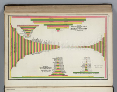
Cram, George Franklin
Full Title
(Statistical Diagrams by state (and selected foreign countries) for railroads, manufactures, debts, telegraph miles, and religious sects (worldwide)).
List No
4727.134
Note
With printed color.
Author
Gray, Ormando Willis
Full Title
Gray's Atlas Map of the United States of America, 1873. (inset) Alaska.
List No
4740.024
Note
Prime meridians Washington D.C. and Greenwich. Relief shown by hachures.
Author
[Kenyon Company, Bankers Life Company]
Full Title
(Covers to) Radio Map Of The United States. Copyrighted 1925. Compiled, Engraved and Published by The Kenyon Company, Inc. Des Moines, Iowa. Compliments of Bankers Life Company of Des Moines, Iowa. Geo. Kuhns, President. The Largest Life Insurance Company West of the Mississippi River Over 768 Million Dollars Insurance In Force.
List No
4774.001
Note
A very early radio map of the U.S. showing location of major radio stations operating in 1925. The country is divided by use of printed color into nine "Radio Districts" and four time zones. There is also a "Log By Wave Length" in which one can record the signal strength of stations received. Folded into yellow card board covers 23x9.5 with "Bankers Life Radio Map of the United States Including Principal Stations in Canada, Cuba and Porto Rico and Mexico Cit, Mexico." printed in dark blue.
Author
[Kenyon Company, Bankers Life Company]
Full Title
Radio Map Of The United States. Copyrighted 1925. Compiled, Engraved and Published by The Kenyon Company, Inc. Des Moines, Iowa. Compliments of Bankers Life Company of Des Moines, Iowa. Geo. Kuhns, President. The Largest Life Insurance Company West of the Mississippi River Over 768 Million Dollars Insurance In Force.
List No
4774.002
Note
A very early radio map of the U.S. showing location of major radio stations operating in 1925. The country is divided by use of printed color into nine "Radio Districts" and four time zones. There is also a "Log By Wave Length" in which one can record the signal strength of stations received. Folded into yellow card board covers 23x9.5 with "Bankers Life Radio Map of the United States Including Principal Stations in Canada, Cuba and Porto Rico and Mexico Cit, Mexico." printed in dark blue.
Author
[Kenyon Company, Bankers Life Company]
Full Title
Log in By Wave Length, Radio Map Of The United States
List No
4774.003
Note
A very early radio map of the U.S. showing location of major radio stations operating in 1925. The country is divided by use of printed color into nine "Radio Districts" and four time zones. There is also a "Log By Wave Length" in which one can record the signal strength of stations received. Folded into yellow card board covers 23x9.5 with "Bankers Life Radio Map of the United States Including Principal Stations in Canada, Cuba and Porto Rico and Mexico Cit, Mexico." printed in dark blue.
Author
[Kenyon Company, Bankers Life Company]
Full Title
Log in By Wave Length (2), Radio Map Of The United States
List No
4774.004
Note
A very early radio map of the U.S. showing location of major radio stations operating in 1925. The country is divided by use of printed color into nine "Radio Districts" and four time zones. There is also a "Log By Wave Length" in which one can record the signal strength of stations received. Folded into yellow card board covers 23x9.5 with "Bankers Life Radio Map of the United States Including Principal Stations in Canada, Cuba and Porto Rico and Mexico Cit, Mexico." printed in dark blue.
Author
[Kenyon Company, Bankers Life Company]
Full Title
Log in By Wave Length (3), Radio Map Of The United States
List No
4774.005
Note
A very early radio map of the U.S. showing location of major radio stations operating in 1925. The country is divided by use of printed color into nine "Radio Districts" and four time zones. There is also a "Log By Wave Length" in which one can record the signal strength of stations received. Folded into yellow card board covers 23x9.5 with "Bankers Life Radio Map of the United States Including Principal Stations in Canada, Cuba and Porto Rico and Mexico Cit, Mexico." printed in dark blue.
Author
[Kenyon Company, Bankers Life Company]
Full Title
(List of Radio Stations), Radio Map Of The United States
List No
4774.006
Note
A very early radio map of the U.S. showing location of major radio stations operating in 1925. The country is divided by use of printed color into nine "Radio Districts" and four time zones. There is also a "Log By Wave Length" in which one can record the signal strength of stations received. Folded into yellow card board covers 23x9.5 with "Bankers Life Radio Map of the United States Including Principal Stations in Canada, Cuba and Porto Rico and Mexico Cit, Mexico." printed in dark blue.
Author
Clason Map Company
Full Title
(Covers to) Radio Broadcasting Stations Of The United States Showing Calls And Divisions Of Time. Copyrighted The C.M. Co. All Rights Reserved.
List No
4775A
Author
Clason Map Company
Full Title
Radio Broadcasting Stations Of The United States Showing Calls And Divisions Of Time. Copyrighted The C.M. Co. All Rights Reserved.
List No
4775.001
Note
The date is estimated. Shows location of radio stations, time zones, and has an index of stations with their "meter lengths" (?). Folded into gray card board covers 16x10 with green and black print; front cover reads "Price 25 Cents Radio Map With Index Of Broadcasting Stations Of United States And Posessions (sic) Canada Mexico Europe. The Clason Map Co. Chicago-Denver." Full color.
Author
American Telephone and Telegraph Co.
Full Title
Keytown telephone sales map : showing primary and secondary calling points and primary calling areas. American Telephone and Telegraph Co., Copyright 1928. Reproduced for selling by Telephone through the courtesy of the American Telephone and Telegraph Co.
List No
8362.000
Note
Color map of the layout of keytown telephone sales areas. Shows state boundaries and associated company boundaries, cities and towns, customers facilities, etc. Notes: Information on Keytown Selling may be obtained at any Bell Company Business Office.
Author
Hagstrom Company, Inc.
Full Title
Radio Tours - America's Latest Game.
List No
8815.004
Note
Includes Call Letter Index, Kilocycle Index, time zones, broadcast Power Code, Chain (network) Affilitations (CBS and NBC) and Radio Set Performance Yardstick. Penciled-in radii from mid-Connecticut of roughly 300, 600, and 900 miles.
Author
Forbell
Full Title
(Covers (Envelope) to) Radio Map of the United States.
List No
9116.001
Author
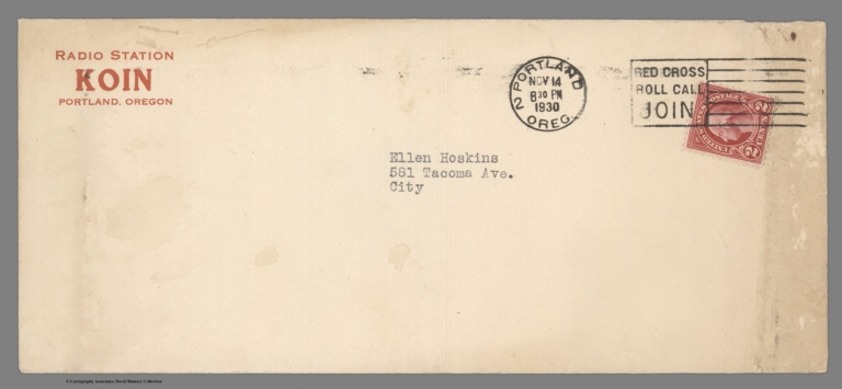
Forbell
Full Title
Radio Map of the United States. Showing KOIN and affiliated Columbia Stations. Presented with Compliments of KOIN, Inc., The Portland News. "The Feature Station of the Great Northwest."
List No
9116.002
Author
Meyerson, Leo
Full Title
Radio Reference Map of the United States. World Radio Laboratories.
List No
9787.001
1-31 of 31
|