|
Author
[Ptolemy, Claudius, Ruscelli,Girolamo, Rosaccio, Giuseppe]
Full Title
Ptolemaei Cognita. Della Geografia di Tolomeo. Libro Settimo. (to accompany) Geographia di Clavdio Tolomeo alessandrino, tradotta di Greco nell'idioma volgare Italiano da Girolamo Ruscelli ... In Venetia, MDXCIX (1599) Appresso gli heredi di M. Sessa.
List No
11299.033
Note
Ruscelli's map of the ancient world as known to Ptolemy. Relief shown pictorially.
Author
[Ptolemy, Claudius, Ruscelli,Girolamo, Rosaccio, Giuseppe]
Full Title
Orbis Terrae Compendiosa Descriptio. Descrittione di tutta la Terra. Libro Primo. (to accompany) Geographia di Clavdio Tolomeo alessandrino, tradotta di Greco nell'idioma volgare Italiano da Girolamo Ruscelli ... In Venetia, MDXCIX (1599) Appresso gli heredi di M. Sessa.
List No
11299.034
Note
Engraved double hemispherical world map. The engraving is a model of clarity and neatness, with typical cursive flourishes to the lettering of the sea names. The North Pole is illustrated as a land mass surrounding a sea from which four rivers radiate, and there is a well depicted northwest passage. Shows a huge southern continent and the bulge in the south west coast of South America. Relief shown pictorially.
Author
[Ptolemy, Claudius, Ruscelli,Girolamo, Rosaccio, Giuseppe]
Full Title
Orbis descriptio. Descrittione dell' Europa. Libro Primo. (to accompany) Geographia di Clavdio Tolomeo alessandrino, tradotta di Greco nell'idioma volgare Italiano da Girolamo Ruscelli ... In Venetia, MDXCIX (1599) Appresso gli heredi di M. Sessa.
List No
11299.035
Note
The second plate of double hemispherical modern copper plate engraving world map,, based upon Gastaldi's world map of 1548. With addition of Southern continent. The map clearly shows the broad mass of land joining Asia and America as Terra Incognita and the coastline as Littus Incongmitum. Relief shown pictorially. Title at head of map: Descrittione dell'Europa. Libro Primo.
Author
[Bertius, Petrus, 1565-1629, Mercator, Gerhard, 1512-1594, Ptolemy, Claudius]
Full Title
Vniversalis tabvla ivxta Pteolemaeum. Tabvlarvm Ptolemaicarvm delineatio ... Ex Clavdii Ptolemaei geogrophicis libris octo orbem totum habitabilem Agathodaemon Alexandrinus mechanicus delineauit. Has vero tabulas descripsit Gerardvs Mercator ... Recensuit varie, correxit, auxitq Petrvs Bertivs ... (to accompany) Theatrum geographiae veteris, duobus tomis distinctum, edente Petro Bertio Bevero.
List No
11296.013
Note
Hand colored map of the world. Relief shown pictorially.
Author
[Bertius, Petrus, 1565-1629, Antoninus Augustus, Welser, Marcus, Peutinger, Conrad]
Full Title
(Composite of) Tabulae Peutingerianae segmentum I - VIII. Tabula Itineraria ex Illustri Peutingerorum Bibliotheca Quae Augustae Vindel. Est. Beneficio Marci Velseri ... in lucem edita ; ... Ioannes Moretus typographus Antverp. S.P.D. ... Antuerpiae e�� Typographieio nostro. Kal. Decemb. M.D. XCVIII. (At upper margin) Tabvlae Pevtingerianae segmentvm primvm. Theatri geographiae veteris : tomus posterior ... Amstelodami : ex officina J. Hondii, Anno 1619. (to accompany) Theatrum geographiae veteris, duobus tomis distinctum, edente Petro Bertio Bevero.
List No
11296.092
Note
Composite of Peutinger 1 to 8 segments. Double page 2 engraved color maps, part of a series of manuscript road maps, showing the Roman view of the world at around the third century. The original ... came into the hands of Konrad Peutinger (1465-1547) and later went to his relative Mark Welser. Welser was the first to publish a copy of it in 1591 ... Ortelius found this copy inadequate. Therefore, in 1598 new manuscript copies were made at his request by Welser. The present set of eight plates on four sheets were engraved following these copies ... Bertius included these prints in his Theatrum geographiae veteris without text, but with geographical indication per strip in 1619"--Broecke, M.P.R. van den, Ortelius atlas maps.
Author
Arrowsmith, John
Full Title
Orbis Veteribus Notus, auctore J. Arrowsmith. London, pubd. 15 Feby. 1832, by J. Arrowsmith, 35 Essex Street, Strand.
List No
0036.001
Note
Engraved map. Hand colored boundaries. Relief shown by hachures. (Mercator projection)
Author
Brue, Adrien Hubert, 1786-1832
Full Title
Carte de l'Empire d'Alexandre par A.H. Brue, Geographe de S.A.R. Monsieur. A Paris, Chez l'Auteur, rue des Macons Sorbonne, no. 9, et chez les principaux marchands de geographie. Fevrier 1822.
List No
0096.003
Note
Hand colored engraved map. Relief shown by hachures.
Author
Brue, Adrien Hubert, 1786-1832
Full Title
Carte de la Palestine sous la domination romaine, dressee par A. Brue, Geographe du Roi, d'apres les observations astronomiques et les voyages le plus recente. (with) Les douze tribus. Paris, 1828. Chez l'Auteur, rue des Macons-Sorbonne, no. 9, et chez les principaux marchands de cartes geographiques. L'Eau-forte des montagnes par E.P. Michel.
List No
0096.005
Note
Hand colored engraved map. Relief shown by hachures. Includes descriptive note.
Author
Brue, Adrien Hubert, 1786-1832
Full Title
Carte generale de la Grece ancienne et de la Mer Egee, comprenant aussi la Macedoine, la Thrace et und partie des pays adjacents. Redigee par A. Brue, Geographe du Roi. Paris, 1827. Chez l'Auteur, rue des Macons-Sorbonne, no. 9, & chez les principaux m(archan)ds de cartes geographiques.
List No
0096.006
Note
Hand colored engraved map. Relief shown by hachures. Prime meridian: Paris.
Author
Brue, Adrien Hubert, 1786-1832
Full Title
Carte generale de l'Asie-Mineure, de l'Armenie, de la Syrie, de la Mesopotamie, du Caucase &a. par A.H. Brue, Geographe de S.A.R. Monsieur. A Paris, Chez l'Auteur, rue des Macons-Sorbonne, no. 9, et chez les principaux marchands de geographie. Mars 1822.
List No
0096.007
Note
Hand colored engraved map. Relief shown by hachures.
Author
Brue, Adrien Hubert, 1786-1832
Full Title
Carte generale de l'Italie ancienne par A. Brue, Geographe du Roi. Paris, 1828. Chez l'Auteur, rue des Macons-Sorbonne, no. 9, et chez les principaux marchands de cartes geographiques.
List No
0096.008
Note
Hand colored engraved map. Relief shown by hachures. Includes insets of the Rome Region and of city of Rome.
Author
Brue, Adrien Hubert, 1786-1832
Full Title
Carte generale des Gaules par A.H. Brue, Geographe de S.A.R. Monsieur. A Paris, Chez l'Auteur, rue des Macons Sorbonne, no. 9, et chez les principaux marchands de geographie. Avril 1821.
List No
0096.009
Note
Hand colored engraved map. Relief shown by hachures. Prime meridian: Paris.
Author
Brue, Adrien Hubert, 1786-1832
Full Title
Carte de l'Espagne ancienne, par A. Brue, Geographe du Roi. Paris, 1827. Chez l'Auteur, rue des Macons-Sorbonne, no. 9, et chez les principaux marchands de cartes geographiques.
List No
0096.010
Note
Hand colored engraved map. Relief shown by hachures. Prime meridian: Paris.
Author
Brue, Adrien Hubert, 1786-1832
Full Title
Carte des Iles Britanniques anciennes par A. Brue ... Carte de la Germanie ancienne, de la Rhetie, de la Pannonie et du Norique par A. Brue, Geographe du Roi ... Paris, 1827. Chez l'Auteur, rue des Macons-Sorbonne, no. 9, et chez les principaux m(archan)ds de cartes geographiques.
List No
0096.011
Note
Two hand colored engraved maps. Relief shown by hachures. Scale of Germanie ancienne is ca. 1:5,200,000. Prime meridian: Paris.
Author
Brue, Adrien Hubert, 1786-1832
Full Title
Carte de la Dacie ancienne, de la Pannonie, de l'Illyrie et de la Moesie; par A. Brue, Geographe du Roi. Paris, 1826. Chez l'Auteur, rue des Macons-Sorbonne, no. 9, et chez les principaux m(archan)ds de cartes geographiques.
List No
0096.012
Note
Hand colored engraved map. Relief shown by hachures.
Author
Brue, Adrien Hubert, 1786-1832
Full Title
Carte generale de l'Empire Romain sous Constantin, par A.H. Brue, Geographe de S.A.R. Monsieur. A Paris, Chez l'Auteur, rue des Macons-Sorbonne, no. 9, et chez les principaux marchands de geographie. Janvier 1822.
List No
0096.013
Note
Hand colored engraved map. Relief shown by hachures. Prime meridian: Paris.
Author
Cram, George Franklin
Full Title
Switzerland. Roman Empire.
List No
0210.071
Note
Prime meridians Greenwich and Washington.
Author
Duval, Henri
Full Title
Atlas Universel. Tableau historique des Empires d'Assyrie, de Babylone, des Medes, des Perses, d'Egypte, de Sicile, &... Par Henri Duval, Chevr. de la Legion d'honneur, Profr. d'Histoire, de Geographie, de Belles-lettres, & &. Paris (1834), Chez l'Auteur, rue de la Chaussee d'Antin, No.15. Johanneau, Rue du Coq. S. Honore 8 bis. ,,, Ate. Foucher.
List No
0254.001
Note
Map of Middle East with chronologies of historic events for each country. Hand tinted text to match mapped areas. Relief shown with sketches.
Author
Duval, Henri
Full Title
Atlas Universel. Tableau historique et geographique de la Grece ancienne, Par Henri Duval, Chevr. de la legion d'honneur, Professeur d'Histoire, de Geographie, de Belles-lettres, & &. Paris (1834), Chez l'Auteur, rue de la Chaussee d'Antin, No.15... Johanneau, Rue du Coq. No. 8 bis. ,,, Ate. Foucher.
List No
0254.002
Note
Map of Greece with chronologies of historic events for each country. Hand tinted text to match mapped areas. Relief shown with sketches.
Author
Duval, Henri
Full Title
Atlas Universel. Tableau historique et Geographique de Rome ancienne, Par Henri Duval, Chevr. de la Legion d'honneur, Professeur d'histoire, de geographie, de belles-lettres, &. Paris (1834), Chez l'Auteur, rue de la Chaussee d'Antin, No.15... Johanneau, Rue du Coq. No. 8 bis. ,,, Ate. Foucher.
List No
0254.003
Note
Map of Roman Empire with chronologies of historic events. Hand tinted text to match mapped areas. Relief shown with simple hachures.
Author
Duval, Henri
Full Title
Atlas Universel. Tableau historique et geographique de l'Histore Sacree, Par Henri Duval, Chevr. de la Legion d'honneur, Professeur d'histoire, de geographie, de belles-lettres, & & &. Paris (1834), Chez l'Auteur, rue de la Chaussee d'Antin, No.15... Johanneau, Rue du Coq. No. 8 bis. ,,, Ate. Foucher.
List No
0254.004
Note
Map of Sacred Lands with chronologies of historic events. Hand tinted text to match mapped areas. Relief shown with sketches.
Author
Duval, Henri
Full Title
Atlas Universel. Tableau historique et geographique de l'Empire d'Oriens ou Bas-Empire et des Croisades. Par Henri Duval, Chevr. de la Legion d'honneur, Professeur d'histoire, de geographie, de belles-lettres, & & &. Paris (1834), Chez l'Auteur, rue de la Chaussee d'Antin, No.15... Johanneau, Rue du Coq. No. 8 bis. ,,, Ate. Foucher.
List No
0254.005
Note
Map of the Empire of the East with chronologies of historic events shown in comparison with reigns of French kings. Hand tinted text to match mapped areas.
Author
Finley, Anthony
Full Title
Terra Veteribus Nota. Thackara Sculpt. Published by A. Finley Philada. 1827.
List No
0285.063
Note
In full color by area.
Author
Finley, Anthony
Full Title
Grecia Antiqua. Published by A. Finley Philada. 1827.
List No
0285.064
Note
Full color by region.
Author
Finley, Anthony
Full Title
Orientis Tabula. J. Vallance fc. Published by A. Finley Philada. 1827.
List No
0285.065
Note
Regions in full color.
Author
Finley, Anthony
Full Title
Asia Minor Antiqua. P.E. Hamm Sc. Published by A. Finley Philada. 1827.
List No
0285.066
Note
In full color by region.
Author
Finley, Anthony
Full Title
Romanum Imperium. Published by A. Finley Philada. 1827.
List No
0285.067
Note
In full color by region showing the extent of the Roman Empire.
Author
Finley, Anthony
Full Title
Italia Antiqua. Published by A. Finley Philada. 1827. (with) inset map of the area surrounding Roma.
List No
0285.068
Note
Classical Italy in full color by region including Sicily, Sardinia, and Corsica.
Author
Finley, Anthony
Full Title
State of Nations at the Christian aera From Pinkerton on the Goths. Published by A. Finley Philada. 1827.
List No
0285.071
Note
In two color with a dividing line stating: "On the north of the Line the Ancients placed the Scythic Ocean: on the East, the Eoan."
Author
Johnson, A.J.
Full Title
Johnson's Roman Empire, Imperium Romanorum Latissime Patens By Johnson And Ward. (insets): No. 104 Graecia. No. 105 Italia.
List No
0352.077
Note
Full color map. Covers Europe as well as parts of North Africa, Asia and Persia. Include lakes, rivers, mountains, major roads, and the names of regions and important cities. Explanatory key noted the ancient and modern names of towns. Relief shown by hachures. Prime meridians are Greenwich and Washington D.C.
Author
Johnson, A.J.
Full Title
Johnson's Roman Empire, in the Time of Christ and his Apostles also Indicating St. Paul's Journeyings. Entered ... 1868. (insets) Graecia and Italia.
List No
0358.071
Author
Kiepert, Heinrich, 1818-1899
Full Title
(Covers to) Atlas antiquus. Zwolf Karten zur alten Geschichte entworfen und bearbeitet von Heinrich Kiepert. Mit Namenverzeichnis. Berlin, Dietrich Reimer (Ernst Vohsen). (1903)
List No
0405A
Note
Light brown cloth covers. "Zwolfte berichtigte Ausgabe." "Drittes hundert tausend."
Author
Kiepert, Heinrich, 1818-1899
Full Title
(Title Page to) Atlas antiquus. Zwolf Karten zur alten Geschichte entworfen und bearbeitet von Heinrich Kiepert. Mit Namenverzeichnis. Berlin, Dietrich Reimer (Ernst Vohsen). (1903)
List No
0405B
Note
1 atlas ([1] leaf, xii folded leaves of plates, [2], 27 p. : 12 col. maps). "Zwolfte berichtigte Ausgabe"--Cover. "Neue berichtigte Ausgabe, 1902"--Namen-Verzeichnis. Latest map revisions dated 1903. Placenames, legends and index in Latin; explanatory material in German. "Drittes hundert tausend"--Cover. Includes contents: 1. Orbis terrarum antiquis notus -- 2. Imperia Persarum et Macedonum -- 3. Aegyptus. Phoenice et Palaestina -- 4. Asia citerior -- 5. Graecia cum insulis et oris maris Aegaei -- 6. Graecia ampliore modulo descripta -- 7. Italia -- 8. Italiae pars media -- 9. Roma urbs -- 10. Hispania, Mauretania et Africa -- 11. Gallia, Britannia, Germania -- 12. Imperium Romanum -- Namenverzeichnis. Light brown cloth covers.
Author
Kiepert, Heinrich, 1818-1899
Full Title
Orbis terrarum altero p. Chr. saeculo antiquis notus. Auctore Henrico Kiepert Berolinensi. (with) Regna orientis antiquissima. (with) Orbis Terrarum secundum Erathoshenem (ca. 200 a. Chr.) (with) Orbis Terrarum secundum Ptolemaeum Alexandrinum (ca. 150 p. Chr.). Geographische Verlagshandlung Dietrich Reimer (Ernst Vohsen) Berlin, Wilhemlstr. 29. (1903)
List No
0405.001
Note
1 color map. Relief shown by hachures. Prime meridian: Ferro.
Author
Kiepert, Heinrich, 1818-1899
Full Title
Imperia Persarum et Macedonum. (with) Regna Diadochorum medio IIIo. a. Chr. saeculo. (with) Regna Graecorum IIo a. Chr. saeculo. Auctore Henrico Kiepert Berolinensi. Geographische Verlagshandlung Dietrich Reimer (Ernst Vohsen) Berlin, Wilhemlstr. 29. (1903)
List No
0405.002
Note
1 color map. Relief shown by hachures.
Author
Kiepert, Heinrich, 1818-1899
Full Title
Aegyptus. Phoenice et Palaestina. (with) Tyrus. (with) Alexandria. (with) XII tribus Israelitarum. (with) Hierosolyma. Auctore H. Kiepert Berolinensi. Geographische Verlagshandlung Dietrich Reimer (Ernst Vohsen) Berlin, Wilhemlstr. 29. (1903)
List No
0405.003
Note
2 color maps. Relief shown by hachures. Prime meridians: Paris and Greenwich. Scale of Phoenice et Palaestina 1:1,250,000.
Author
Kiepert, Heinrich, 1818-1899
Full Title
Asia citerior. Auctore Henrico Kiepert Berolinensi. Geographische Verlagshandlung Dietrich Reimer (Ernst Vohsen) Berlin, Wilhemlstr. 29. (1903)
List No
0405.004
Note
1 color map. Relief shown by hachures. Prime meridian: Paris.
Author
Kiepert, Heinrich, 1818-1899
Full Title
Graecia cum insulis et oris maris Aegaei. (with) Troas et Hellespontus. Auctore Henrico Kiepert Berolinensi. Geographische Verlagshandlung Dietrich Reimer (Ernst Vohsen) Berlin, Wilhemlstr. 29. (1903)
List No
0405.005
Note
1 color map. Relief shown by hachures. Prime meridians: Paris and Greenwich.
Author
Kiepert, Heinrich, 1818-1899
Full Title
Graecia. (with) Athenae. (with) Regiones proximae circa urbem Athenas. Auctore Henrico Kiepert Berolinensi. Geographische Verlagshandlung Dietrich Reimer (Ernst Vohsen) Berlin, Wilhemlstr. 29. IV.1903.
List No
0405.006
Note
1 color map. Relief shown by hachures. Prime meridians: Paris and Greenwich.
Author
Kiepert, Heinrich, 1818-1899
Full Title
Italia. (with) Undecim regiones Italiae ab Augusto Imp. institutae. Auctore Henrico Kiepert Berolinensi. Geographische Verlagshandlung Dietrich Reimer (Ernst Vohsen) Berlin, Wilhemlstr. 29. (1903)
List No
0405.007
Note
1 color map. Relief shown by hachures. Prime meridians: Paris and Greenwich.
Author
Kiepert, Heinrich, 1818-1899
Full Title
Italiae pars media. (with) Magna Graecia sive Italia Inferior cum Sicilia, VIII-V a. Chr. saeculo. (with) Syracusae. (with Neapolis). (with) Latium antiquissimum. Auctore Henrico Kiepert Berolinensi. Geographische Verlagshandlung Dietrich Reimer (Ernst Vohsen) Berlin, Wilhemlstr. 29. (1903)
List No
0405.008
Note
1 color map. Relief shown by hachures. Prime meridians: Paris and Greenwich.
Full Title
Roma urbs ab Augusti Imp. tempore cum muris ab Aureliano et Honorio conditis. (with) Roma urbs tempore liberae reipublicae cum IV regionibus a Ser. Tullio conditis Capitolio et Aventino extra pomerium relictis. (with) Forum Romanum et fora Caesarum cum Capitolio et regione circumiacente quadruplici maioris tabulae modulo descripta. (with) Forum Romanum quo statu tempore liberae reipublicae fuisse videtur. (Auctore Henrico Kiepert Berolinensi). Geographische Verlagshandlung Dietrich Reimer (Ernst Vohsen) Berlin, Wilhemlstr. 29. (1903)
List No
0405.009
Note
1 color map. Relief shown by hachures.
Author
Kiepert, Heinrich, 1818-1899
Full Title
Hispania, Mauretania et Africa. (with) Carthago. (with) Provinciae Carthaginiensibus subditae. Auctore Henrico Kiepert Berolinensi. Geographische Verlagshandlung Dietrich Reimer (Ernst Vohsen) Berlin, Wilhemlstr. 29. X.1901 (1903)
List No
0405.010
Note
1 color map. Relief shown by hachures. Prime meridians: Paris and Greenwich.
Author
Kiepert, Heinrich, 1818-1899
Full Title
Gallia, Britannia, Germania, Provinciae danuvienses. Auctore Henrico Kiepert Berolinensi. Geographische Verlagshandlung Dietrich Reimer (Ernst Vohsen) Berlin, Wilhemlstr. 29. IV.1903.
List No
0405.011
Note
1 color map. Relief shown by hachures. Includes inset. Prime meridians: Greenwich and Paris.
Author
Kiepert, Heinrich, 1818-1899
Full Title
Imperium Romanum. (with) Imperium Romanum in praefecturas, dioceses, provincias divisum. Auctore Henrico Kiepert Berolinensi. Geographische Verlagshandlung Dietrich Reimer (Ernst Vohsen) Berlin, Wilhemlstr. 29. (1903)
List No
0405.012
Note
1 color map. Relief shown by hachures.
Author
Malte-Brun, Conrad, 1775-1826
Full Title
Geographie Primitive des Grecs. 1831. No. 2. Hesiode, Homere, Orphee, Voyages des Argonautes, et D'Ulysse, neuf siecles avant notre ere. Grave par Thierry.
List No
0458.002
Note
Engraved map with continent boundaries trimmed in color. Shows routes of Ulysses and the Argonauts. Major relief shown by hachures. Rivers, lakes, islands, peoples, and regions shown. Insets showing Systeme de Democrite, 4th century B.C., and Systeme de Scylax d'Eudoxe et d'Ephore, 4th and 5th centuries B.C.
Author
Malte-Brun, Conrad, 1775-1826
Full Title
Geographie d'Herodote, 1831. No. 3. Longitude du Meridien de Lutece. Grave par Thierry.
List No
0458.003
Note
Engraved map with continent boundaries trimmed in color. Major relief shown by hachures. Rivers, lakes, islands, peoples, and regions shown. Text in Latin.
Author
Malte-Brun, Conrad, 1775-1826
Full Title
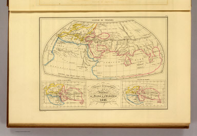
Systemes Geographiques de Ptolemee, de Strabon & d'Eratosthene, 1831. No. 4. Grave par Thierry.
List No
0458.004
Note
Engraved map with continent boundaries trimmed in color. Major relief shown by hachures. Rivers, lakes, islands, peoples, and regions shown. In three sections: System of Ptolemy at 1:70,000,000; System of Eratosthene at 1:140,000,000; System of Strabon at 1: 140,000,000. Text in Latin.
Author
Malte-Brun, Conrad, 1775-1826
Full Title
Empire d'Alexandre. No. 5. Longitude du Meridien de Lutece. Grave par Thierry. (1837)
List No
0458.005
Note
Engraved map with continent boundaries trimmed in color. Major relief shown by hachures. Rivers, lakes, islands, peoples, and regions shown. Text in Latin.
Author
Mellish, John
Full Title
(Covers to) An Atlas Of Ten Select Maps Of Ancient Geography Both Sacred And Profane; With A Chronological Table Of Universal History & Biography. Being Intended As An Accompaniment To Mayo's Ancient Geography And History. Calculated For The Use Of Seminaries, &c. Philadelphia: Published By John Mellish (sic), No. 49 South Third Street, And Sold By The Principal Booksellers In The United States. 1815.
List No
0497.001
Note
Maps copied from Wilkinson's Atlas Classica. This becomes the Finley Ancient Atlas. Lucas also used many of these maps in his General Atlas of 1823. Includes 8 maps and 1 chart. Maps are hand colored. Covers are half leather, marbled paper covered boards.
|