|
Author
Ilyin, A.
Full Title
Karta glavneishikh lechebnykh mest Evropy [Map of Major Healing Places in Europe].
List No
15953.000
Note
Date estimated
Author
Zettle, Ludwig (1821-1891)
Full Title
(Covers to) Plan der Haupt-u. Residenz Stadt Wein mit der neuen Bezirkseintheilung, Strassenbenennung under Häuser-Nummerirung.
List No
15960.001
Author
Zettle, Ludwig (1821-1891)
Full Title
Plan der Haupt-u. Residenz Stadt Wein mit der neuen Bezirkseintheilung, Strassenbenennung under Häuser-Nummerirung.
List No
15960.002
Author
[Aeronautical Chart and Information Center (U.S.), United States. National Aeronautics and Space Administration]
Full Title
(Covers to) Ranger VII Lunar chart. RLC 1 -5. Compiled and published for National Aeronautics and Space Administration by Aeronautical Chart and Information Center, United States Air Force. Base 100. Base information October 1964. Lithographed by ACIC 1964.
List No
13542.001
Note
Covers to Ranger 7 map of the moons surface RLC 1-5.
Author
[Aeronautical Chart and Information Center (U.S.), United States. National Aeronautics and Space Administration]
Full Title
Ranger VII Lunar chart. Mare Cognitum RLC 1
List No
13542.002
Note
2 maps on 1 sheet, both sides. Mare Cognitum: Lunar 7 RLC 1.
Author
[Aeronautical Chart and Information Center (U.S.), United States. National Aeronautics and Space Administration]
Full Title
Ranger VII Lunar chart. Mare Cognitum RLC 2
List No
13542.003
Note
2 maps on 1 sheet, both sides. Mare Cognitum: Lunar 7 RLC 1.
Author
[Aeronautical Chart and Information Center (U.S.), United States. National Aeronautics and Space Administration]
Full Title
Ranger VII Lunar chart. Guericke : Mare Cognitum RLC 2
List No
13542.004
Note
2 maps on 1 sheet, both sides. Guericke: Mare Cognitum: Lunar 7 RLC 2.
Author
[Aeronautical Chart and Information Center (U.S.), United States. National Aeronautics and Space Administration]
Full Title
Ranger VII Lunar chart. Guericke : Mare Cognitum RLC 2
List No
13542.005
Note
2 maps on 1 sheet, both sides. Guericke: Mare Cognitum: Lunar 7 RLC 2.
Author
[Aeronautical Chart and Information Center (U.S.), United States. National Aeronautics and Space Administration]
Full Title
Ranger VII Lunar chart. Bonpland H : Mare Cognitum RLC 3
List No
13542.006
Note
2 maps on 1 sheet, both sides. Bonpland H: Mare Cognitum: : Lunar 7 RLC 3.
Author
[Aeronautical Chart and Information Center (U.S.), United States. National Aeronautics and Space Administration]
Full Title
Ranger VII Lunar chart. Bonpland H : Mare Cognitum RLC 3
List No
13542.007
Note
2 maps on 1 sheet, both sides. Bonpland H: Mare Cognitum: : Lunar 7 RLC 3.
Author
[Aeronautical Chart and Information Center (U.S.), United States. National Aeronautics and Space Administration]
Full Title
Ranger VII Lunar chart. Bonpland PQC : Mare Cognitum RLC 4
List No
13542.008
Note
2 maps on 1 sheet, both sides. Bonpland PQC : Mare Cognitum: Lunar 7 RLC 4.
Author
[Aeronautical Chart and Information Center (U.S.), United States. National Aeronautics and Space Administration]
Full Title
Ranger VII Lunar chart. Bonpland PQC : Mare Cognitum RLC 4
List No
13542.009
Note
2 maps on 1 sheet, both sides. Bonpland PQC : Mare Cognitum: Lunar 7 RLC 4.
Author
[Aeronautical Chart and Information Center (U.S.), United States. National Aeronautics and Space Administration]
Full Title
Ranger VII Lunar chart. RLC 5
List No
13542.010
Note
2 maps on 1 sheet, both sides. Ranger 7 Lunar chart. RLC 5.
Author
[Aeronautical Chart and Information Center (U.S.), United States. National Aeronautics and Space Administration]
Full Title
(Covers to) Ranger IX Lunar chart. RLC 13 - 17. Compiled and published for National Aeronautics and Space Administration by Aeronautical Chart and Information Center, United States Air Force. Base 100. Base information May 1966. Lithographed by ACIC 6-66.
List No
13544.001
Note
Covers to Ranger 9, map of the moon surface RLC 13-17.
Author
[Aeronautical Chart and Information Center (U.S.), United States. National Aeronautics and Space Administration]
Full Title
Ranger IX Lunar chart: Ptolemaeus RLC 13
List No
13544.002
Note
2 maps on 1 sheet, both sides. Ptolemaeus Lunar 9 RLC 13.
Author
[Aeronautical Chart and Information Center (U.S.), United States. National Aeronautics and Space Administration]
Full Title
Ranger IX Lunar chart: Ptolemaeus RLC 13
List No
13544.003
Note
2 maps on 1 sheet, both sides. Ptolemaeus Lunar 9 RLC 13.
Author
[Aeronautical Chart and Information Center (U.S.), United States. National Aeronautics and Space Administration]
Full Title
Ranger IX Lunar chart: Alphonsus RLC 14
List No
13544.004
Note
2 maps on 1 sheet, both sides. Alphonsus Lunar 9 RLC 14.
Author
[Aeronautical Chart and Information Center (U.S.), United States. National Aeronautics and Space Administration]
Full Title
Ranger IX Lunar chart: Alphonsus RLC 14
List No
13544.005
Note
2 maps on 1 sheet, both sides. Alphonsus Lunar 9 RLC 14.
Author
[Aeronautical Chart and Information Center (U.S.), United States. National Aeronautics and Space Administration]
Full Title
Ranger IX Lunar chart: Alphonsus GA RLC 15
List No
13544.006
Note
2 maps on 1 sheet, both sides. Alphonsus GA Lunar 9 RLC 15.
Author
[Aeronautical Chart and Information Center (U.S.), United States. National Aeronautics and Space Administration]
Full Title
Ranger IX Lunar chart: Alphonsus GA RLC 15
List No
13544.007
Note
2 maps on 1 sheet, both sides. Alphonsus GA Lunar 9 RLC 15.
Author
[Aeronautical Chart and Information Center (U.S.), United States. National Aeronautics and Space Administration]
Full Title
Ranger IX Lunar chart: Alphonsus GP RLC 16
List No
13544.008
Note
2 maps on 1 sheet, both sides. Alphonsus GP Lunar 9 RLC 16.
Author
[Aeronautical Chart and Information Center (U.S.), United States. National Aeronautics and Space Administration]
Full Title
Ranger IX Lunar chart: Alphonsus GP RLC 16
List No
13544.009
Note
2 maps on 1 sheet, both sides. Alphonsus GP Lunar 9 RLC 16.
Author
[Aeronautical Chart and Information Center (U.S.), United States. National Aeronautics and Space Administration]
Full Title
Ranger IX Lunar chart. RLC 13 - 17. Compiled and published for National Aeronautics and Space Administration by Aeronautical Chart and Information Center, United States Air Force. Base 100. Base information May 1966. Lithographed by ACIC 6-66.
List No
13544.010
Note
2 maps on 1 sheet, both sides. Alphonsus GLH Lunar 9 RLC 17.
Author
United States. Board of Consulting Engineers for Panama Canal
Full Title
(Title Page to) Report of Board of Consulting Engineers for Panama Canal. Washington : government Printing Office, 1906. (with) Report of Board of Consulting Engineers for Panama Canal, maps and diagrams.
List No
13139.002
Note
2 volumes, Volume 1, Text: contains 426 pages of text, appendixes and diagrams, Bound in embossed brown cloth covered boards with title in gilt on spine. Volume 2, Maps and diagrams: contains 31 folded maps and diagrams, with XXI pages of: "Letters transmitting the Report of Board of Consulting Engineers for Panama Canal". In brown cloth covered case with title in gilt on spine. Volumes contain data on Canal design, construction, costs, equipment needed, employment, labor force needed, and employee vital statistics; ships; harbors; rivers; and other canal and harbor resources.
Author
United States. Board of Consulting Engineers for Panama Canal
Full Title
(Index Page to) Report of Board of Consulting Engineers for Panama Canal. Washington : government Printing Office, 1906. (with) Report of Board of Consulting Engineers for Panama Canal, maps and diagrams.
List No
13139.006
Note
2 volumes, Volume 1, Text: contains 426 pages of text, appendixes and diagrams, Bound in embossed brown cloth covered boards with title in gilt on spine. Volume 2, Maps and diagrams: contains 31 folded maps and diagrams, with XXI pages of: "Letters transmitting the Report of Board of Consulting Engineers for Panama Canal". In brown cloth covered case with title in gilt on spine. Volumes contain data on Canal design, construction, costs, equipment needed, employment, labor force needed, and employee vital statistics; ships; harbors; rivers; and other canal and harbor resources.
Author
United States. Board of Consulting Engineers for Panama Canal
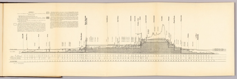
Full Title
Appendix F. (to accompany) Report of Board of Consulting Engineers for Panama Canal. Washington : government Printing Office, 1906. (with) Report of Board of Consulting Engineers for Panama Canal, maps and diagrams.
List No
13139.013
Note
Profile of the Panama route on folded plate. 465A-06. (To face page 238.)
Author
United States. Board of Consulting Engineers for Panama Canal
Full Title
Appendix J. Typical cross section of Canal. (to accompany) Report of Board of Consulting Engineers for Panama Canal. Washington : government Printing Office, 1906. (with) Report of Board of Consulting Engineers for Panama Canal, maps and diagrams.
List No
13139.014
Note
Cross section of Canal on folded plate. 465A-06. (To face page 367.)
Author
United States. Board of Consulting Engineers for Panama Canal
Full Title
Steam shovel progress on average maximum section ... The Noris Peters Co., Washington, D.C. (to accompany) Report of Board of Consulting Engineers for Panama Canal. Washington : government Printing Office, 1906. (with) Report of Board of Consulting Engineers for Panama Canal, maps and diagrams.
List No
13139.015
Note
Color diagram on folded sheet. Includes note.
Author
United States. Board of Consulting Engineers for Panama Canal
Full Title
Steam shovel progress Maximum section at kilometer 54.74, lenght of section 800 feet ... The Noris Peters Co., Washington, D.C. (to accompany) Report of Board of Consulting Engineers for Panama Canal. Washington : government Printing Office, 1906. (with) Report of Board of Consulting Engineers for Panama Canal, maps and diagrams.
List No
13139.016
Note
Color diagram on folded sheet. Includes note.
Author
United States. Board of Consulting Engineers for Panama Canal
Full Title
Steam shovel progress Maximum section at kilometer 54.74, lenght of section 800 feet ... The Noris Peters Co., Washington, D.C. (to accompany) Report of Board of Consulting Engineers for Panama Canal. Washington : government Printing Office, 1906. (with) Report of Board of Consulting Engineers for Panama Canal, maps and diagrams.
List No
13139.017
Note
Diagram on folded sheet. Showing maximum and minimum number of Steam shovels at work in different phases through. Includes note.
Author
United States. Board of Consulting Engineers for Panama Canal
Full Title
(Title Page to) Report of Board of Consulting Engineers for Panama Canal, maps and diagrams. (with) Report of Board of Consulting Engineers for Panama Canal. Washington : government Printing Office, 1906.
List No
13139.024
Note
2 volumes, Volume 1, Text: contains 426 pages of text, appendixes and diagrams, Bound in embossed brown cloth covered boards with title in gilt on spine. Volume 2, Maps and diagrams: contains 31 folded maps and diagrams, with XXI pages of: "Letters transmitting the Report of Board of Consulting Engineers for Panama Canal". In brown cloth covered case with title in gilt on spine. Volumes contain data on Canal design, construction, costs, equipment needed, employment, labor force needed, and employee vital statistics; ships; harbors; rivers; and other canal and harbor resources.
Author
United States. Board of Consulting Engineers for Panama Canal
Full Title
(Contents to) Report of Board of Consulting Engineers for Panama Canal, maps and diagrams.
List No
13139.026
Note
List of maps and diagrams printed inside front cover in volume 2.
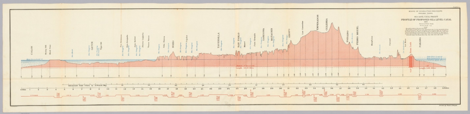
Author
United States. Board of Consulting Engineers for Panama Canal
Full Title
Board of Consulting Engineers Panama Canal - Sea level canal project : Map showing line of proposed sea level canal. 1905. (to accompany) Report of Board of Consulting Engineers for Panama Canal, maps and diagrams. (with) Report of Board of Consulting Engineers for Panama Canal. Washington : government Printing Office, 1906.
List No
13139.027
Note
Folded color map. Includes legend and notes: "Topography is taken from a map published by the New Panama Canal Co."
Author
United States. Board of Consulting Engineers for Panama Canal
Full Title
Board of Consulting Engineers Panama Canal - Sea level canal project : Profile of proposed sea level canal. 1905. Drawn by Chas. L. Hoopes. Julius Bien & Co. N.Y. (to accompany) Report of Board of Consulting Engineers for Panama Canal, maps and diagrams. (with) Report of Board of Consulting Engineers for Panama Canal. Washington : government Printing Office, 1906.
List No
13139.028
Note
Folded color map. Includes notes: Profile is taken from Axis of Canal."
Author
United States. Board of Consulting Engineers for Panama Canal
Full Title
Board of Consulting Engineers Panama Canal - Sea level canal project : Proposed cross sections. 1905. Julius Bien & Co. N.Y. (to accompany) Report of Board of Consulting Engineers for Panama Canal, maps and diagrams. (with) Report of Board of Consulting Engineers for Panama Canal. Washington : government Printing Office, 1906.
List No
13139.029
Note
Folded color cross sections.
Author
United States. Board of Consulting Engineers for Panama Canal
Full Title
Board of Consulting Engineers Panama Canal - Lock Canal project. Profile of proposed Rock Canal with summit elevation at 60 feet, approved by the Board for comparison. Drawn by Chas. L. Hoopes. Julius Bien & Co. N.Y. (to accompany) Report of Board of Consulting Engineers for Panama Canal, maps and diagrams. (with) Report of Board of Consulting Engineers for Panama Canal. Washington : government Printing Office, 1906.
List No
13139.030
Note
Folded color profile. Includes note: "The profile is taken on the Axis of Canal ..."
Author
United States. Board of Consulting Engineers for Panama Canal
Full Title
Board of Consulting Engineers Panama Canal - Sea level canal project : Map showing location of proposed Gamboa Dam. Julius Bien & Co. N.Y. (to accompany) Report of Board of Consulting Engineers for Panama Canal, maps and diagrams. (with) Report of Board of Consulting Engineers for Panama Canal. Washington : government Printing Office, 1906.
List No
13139.031
Note
Folded color map. Relief shown by contours and spot heights. Shows location of Bore Holes and line of proposed Dam. Note: "Topography is from surveys of Isthmian Canal Commission, 1905."
Author
United States. Board of Consulting Engineers for Panama Canal
Full Title
Board of Consulting Engineers Panama Canal - Sea level canal project : Profile on line of proposed Gamboa Dam showing depths to rock. Julius Bien & Co. N.Y. Thos. O. Wansleben del. (to accompany) Report of Board of Consulting Engineers for Panama Canal, maps and diagrams. (with) Report of Board of Consulting Engineers for Panama Canal. Washington : government Printing Office, 1906.
List No
13139.032
Note
Folded color profile. Relief shown by contours and spot heights. Shows location of Bore Holes and line of proposed Dam. Note: "Topography is from surveys of Isthmian Canal Commission, 1905."
Author
United States. Board of Consulting Engineers for Panama Canal
Full Title
Board of Consulting Engineers Panama Canal - Map and profiles : Showing the location of Borings in the vicinity of La Boca. 1905. Julius Bien & Co. N.Y. (to accompany) Report of Board of Consulting Engineers for Panama Canal, maps and diagrams. (with) Report of Board of Consulting Engineers for Panama Canal. Washington : government Printing Office, 1906.
List No
13139.033
Note
Folded color map and profiles. Relief shown by contours and spot heights. Includes Note: "Topography is reduced from map of the New Panama Canal Co."
Author
United States. Board of Consulting Engineers for Panama Canal
Full Title
Board of Consulting Engineers Panama Canal - Lock Canal project. Map showing line of proposed Lock Canal with summit elevation at 85 feet 1905. Julius Bien & Co. N.Y. (to accompany) Report of Board of Consulting Engineers for Panama Canal, maps and diagrams. (with) Report of Board of Consulting Engineers for Panama Canal. Washington : government Printing Office, 1906.
List No
13139.034
Note
Folded color map and profiles. Relief shown by hachures. Includes legend and Note: "Topography taken from a map published by the New Panama Canal Co."
Author
United States. Board of Consulting Engineers for Panama Canal
Full Title
Board of Consulting Engineers Panama Canal - Lock Canal project. Profile of proposed Lock Canal with summit elevation at 85 feet 1905. Julius Bien & Co. N.Y. (to accompany) Report of Board of Consulting Engineers for Panama Canal, maps and diagrams. (with) Report of Board of Consulting Engineers for Panama Canal. Washington : government Printing Office, 1906.
List No
13139.035
Note
Folded color profile. Includes Note: "Profile is taken on the Axis of Canal."
Author
United States. Board of Consulting Engineers for Panama Canal
Full Title
Board of Consulting Engineers Panama Canal - Lock Canal project. Cross sections of proposed Lock Canal with summit elevation at 85 feet 1905. Julius Bien & Co. N.Y. (to accompany) Report of Board of Consulting Engineers for Panama Canal, maps and diagrams. (with) Report of Board of Consulting Engineers for Panama Canal. Washington : government Printing Office, 1906.
List No
13139.036
Note
Folded color cross sections.
Author
United States. Board of Consulting Engineers for Panama Canal
Full Title
Board of Consulting Engineers Panama Canal - Lock Canal project. Map in the vicinity of Gatun showing location of proposed dam and locks 1905. Julius Bien & Co. N.Y. (to accompany) Report of Board of Consulting Engineers for Panama Canal, maps and diagrams. (with) Report of Board of Consulting Engineers for Panama Canal. Washington : government Printing Office, 1906.
List No
13139.037
Note
Folded color map. Relief shown by contours and spot heights. Note: Topography and borings from surveys made in 1905.
Author
United States. Board of Consulting Engineers for Panama Canal
Full Title
Board of Consulting Engineers Panama Canal - Lock Canal project. Profiles showing new borings at Gatun 1905. Julius Bien & Co. N.Y. (to accompany) Report of Board of Consulting Engineers for Panama Canal, maps and diagrams. (with) Report of Board of Consulting Engineers for Panama Canal. Washington : government Printing Office, 1906.
List No
13139.038
Note
Folded profiles A-H, showing new borings at Gatun.
Author
United States. Board of Consulting Engineers for Panama Canal
Full Title
Board of Consulting Engineers Panama Canal - Lock Canal project. Plan of regulating works at Gatun Dam 1905. Julius Bien & Co. N.Y. (to accompany) Report of Board of Consulting Engineers for Panama Canal, maps and diagrams. (with) Report of Board of Consulting Engineers for Panama Canal. Washington : government Printing Office, 1906.
List No
13139.039
Note
Folded color plan and sections.
Author
Roberts, R. C.
Full Title
(Covers/ Title to) Maps to accompany soil survey of Puerto Rico 1942. (map title) Soil Survey of Puerto Rico. U.S. Department of Agriculture and Bureau of Chemistry and Soils, Henry G. Knight, Chief. Soil survey Division, Charles E. Kellogg, Chief. University of Puerto Rico, Agricultural experiment Station. F.A. Lopez Dominguez, Director. J.A. Bonnet, Chief, Soil Divsion. Mark Baldwin, Inspector, District 1. Soil survey by R.C. Roberts and party. Litho. A. Hoen & Co. Inc. Field operations, Bureau of Chemistry and Soils 1936.
List No
13459.001
Author
Roberts, R. C.
Full Title
Soil map : Puerto Rico : Eastern sheet. (to accompany) Maps to accompany soil survey of Puerto Rico 1942.
List No
13459.002
Note
Soil map Eastern sheet, includes 3 insets and legend.
Author
Roberts, R. C.
Full Title
Soil map : Puerto Rico : Western sheet. (to accompany) Maps to accompany soil survey of Puerto Rico 1942.
List No
13459.003
Note
Soil map Western sheet, includes 2 inset and legend.
Author
Roberts, R. C.
Full Title
Soil map : Puerto Rico : East-Central sheet. (to accompany) Maps to accompany soil survey of Puerto Rico 1942.
List No
13459.004
Note
Soil map East-Central sheet, includes legend.
Author
Roberts, R. C.
Full Title
Soil map : Puerto Rico : West-Central sheet. (to accompany) Maps to accompany soil survey of Puerto Rico 1942.
List No
13459.005
Note
Soil map West-Central sheet, includes 2 insets and legend.
Author
Roberts, R. C.
Full Title
Soil legend : Puerto Rico. (to accompany) Maps to accompany soil survey of Puerto Rico 1942.
List No
13459.006
Note
Soil legend and index.
Author
Roberts, R. C.
Full Title
Nomenclatura de Suelos : Puerto Rico. (to accompany) Maps to accompany soil survey of Puerto Rico 1942.
List No
13459.007
Note
Soil legend and index in Spanish.
Author
Roberts, R. C.
Full Title
(Composite map of) (4 Sheets) Soil map : Puerto Rico : West-Central sheet. (to accompany) Maps to accompany soil survey of Puerto Rico 1942.
List No
13459.008
Author
[Geological Survey (U.S.), Conant, Louis C., Goudarzi, Gus H.]
Full Title
Geologic map of the Kingdom of Libya = خريطة جيولوجية للمملكة الليبية = Kharīṭah jiyūlūjīyah lil-Mamlakah al-Lībyah. Compiled by Louis C. Conant and Gus H. Goudarzi under the joint sponsership of the Kingdom of Libya and the Agency for International Development, U. S. Department of State. 1964. Department of Interior, United States Geological Survey. Kingdom of Libya. Ministries of National Economy, Petroleum Affairs, and Industry. Miscellaneous Geological Investigations, Map 1-350 A.
List No
13541.002
Note
Color geological map of Libya. Published by the U.S. Geological Survey, Washington, D.C., 1964.
Author
[Ziegler, J. M., Stanford, Edward]
Full Title
(Covers to) Physical Map of the Island of Madeira constructed by J.M. Ziegler, Crrspg. F.R.G.S.ty from that of Captain Vidal, R.N. with Corrections . . .
List No
15940.001
Author
[Ziegler, J. M., Stanford, Edward]
Full Title
Physical Map of the Island of Madeira constructed by J.M. Ziegler, Crrspg. F.R.G.S.ty from that of Captain Vidal, R.N. with Corrections . . .
List No
15940.002
Author
Surveyor General of India.
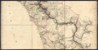
Full Title
(Covers to) The Punjab and Its Dependencies with Portions of the Northwest Provinces and Afghanistan. 1870. Compiled by the Surveyor General of India from the Latest Surveys. Second Edition. Published under the Direction of Colonel H.L. Thuiilier. Surveyor General's Office.
List No
7854.001
Note
Four large canvas backed sheets each dissected into 18 panels and mounted on linen for folding into a slipcase. Sheets 1 and 4 have one panel backed with blue marbled paper. Slipcase spine has text, "Punjab" in gilt.
Author
Surveyor General of India.
Full Title
Sheet 1. N.W. Punjab.
List No
7854.002
Author
Surveyor General of India.
Full Title
Sheet 2. N.E. Punjab.
List No
7854.003
Author
Surveyor General of India.
Full Title
Sheet 3. S.W. Punjab.
List No
7854.004
Author
Surveyor General of India.
Full Title
Sheet 4. S.E. Punjab.
List No
7854.005
Author
Surveyor General of India.
Full Title
(Composite map of) Sheets 1 - 4.
List No
7854.006
Author
Transkartografiia (Soviet Union)
Full Title
Skhematicheskaiakarta zheleznodorozhnykh, vodnykh i avtomobilʹnykh putei soobshcheniia SSSR. Po dannym na 1 ianvaria 1934 goda. Glavlit no. V-71873. 1-aia Kartograficheskaia F-ka im Dunaeva Moskva b. Polianka, 9.(insets) Leningradski Uzel . (with) Murmanskaia. (with) Donbass. (with) Mskovskiia Uzel.
List No
11427.002
Author
Transkartografiia (Soviet Union)
Full Title
Skhematicheskaiakarta zheleznodorozhnykh, vodnykh i avtomobilʹnykh putei soobshcheniia SSSR. Po dannym na 1 ianvaria 1934 goda. Glavlit no. V-71873. 1-aia Kartograficheskaia F-ka im Dunaeva Moskva b. Polianka, 9.(insets) Leningradski Uzel . (with) Murmanskaia. (with) Donbass. (with) Mskovskiia Uzel.
List No
11427.004
Author
Transkartografiia (Soviet Union)
Full Title
Skhematicheskaiakarta zheleznodorozhnykh, vodnykh i avtomobilʹnykh putei soobshcheniia SSSR. Po dannym na 1 ianvaria 1934 goda. Glavlit no. V-71873. 1-aia Kartograficheskaia F-ka im Dunaeva Moskva b. Polianka, 9.(insets) Leningradski Uzel . (with) Murmanskaia. (with) Donbass. (with) Mskovskiia Uzel.
List No
11427.006
Author
Transkartografiia (Soviet Union)
Full Title
Skhematicheskaiakarta zheleznodorozhnykh, vodnykh i avtomobilʹnykh putei soobshcheniia SSSR. Po dannym na 1 ianvaria 1934 goda. Glavlit no. V-71873. 1-aia Kartograficheskaia F-ka im Dunaeva Moskva b. Polianka, 9.(insets) Leningradski Uzel . (with) Murmanskaia. (with) Donbass. (with) Mskovskiia Uzel.
List No
11427.008
Author
Transkartografiia (Soviet Union)
Full Title
(Composite map) Skhematicheskaiakarta zheleznodorozhnykh, vodnykh i avtomobilʹnykh putei soobshcheniia SSSR. Po dannym na 1 ianvaria 1934 goda. Glavlit no. V-71873. 1-aia Kartograficheskaia F-ka im Dunaeva Moskva b. Polianka, 9.(insets) Leningradski Uzel . (with) Murmanskaia. (with) Donbass. (with) Mskovskiia Uzel.
List No
11427.009
Note
Composite to sheet 1-4 of the railway, water and motor ways of the USSR.
Author
Hyde & Company
Full Title
(Covers to) Map Of Long Island. Library Edition. Based Upon Recent U.S. Coast Surveys, Together With Local Maps On File. Supplemented By Careful Territorial Observations. Published By Hyde & Company, Classon Ave. cor. Fulton St. Brooklyn, N.Y. July 1896. Entered ... 1896, by Hyde & Company ... Washington. Balliet & Volk, Map Engravers, 27 So. 6th St., Phila, Pa.
List No
4626.001
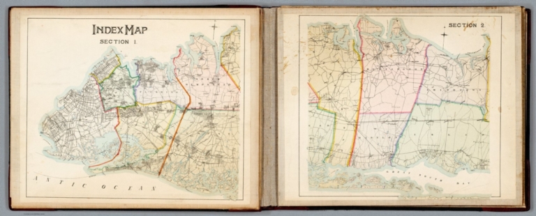
Author
Hyde & Company
Full Title
Index Map Section 1 and Section 2. Map Of Long Island. Library Edition. Based Upon Recent U.S. Coast Surveys, Together With Local Maps On File. Supplemented By Careful Territorial Observations. Published By Hyde & Company, Classon Ave. cor. Fulton St. Brooklyn, N.Y. July 1896. Entered ... 1896, by Hyde & Company ... Washington. Balliet & Volk, Map Engravers, 27 So. 6th St., Phila, Pa.
List No
4626.002
Author
Hyde & Company
Full Title
(Section 1) Map Of Long Island. Library Edition. Based Upon Recent U.S. Coast Surveys, Together With Local Maps On File. Supplemented By Careful Territorial Observations. Published By Hyde & Company, Classon Ave. cor. Fulton St. Brooklyn, N.Y. July 1896. Entered ... 1896, by Hyde & Company ... Washington. Balliet & Volk, Map Engravers, 27 So. 6th St., Phila, Pa.
List No
4626.003
Author
Hyde & Company
Full Title
(Section 2) Map Of Long Island. Library Edition. Based Upon Recent U.S. Coast Surveys, Together With Local Maps On File. Supplemented By Careful Territorial Observations. Published By Hyde & Company, Classon Ave. cor. Fulton St. Brooklyn, N.Y. July 1896. Entered ... 1896, by Hyde & Company ... Washington. Balliet & Volk, Map Engravers, 27 So. 6th St., Phila, Pa.
List No
4626.004
Author
Hyde & Company
Full Title
(Composite (Sections 1 and 2)) Map Of Long Island. Library Edition. Based Upon Recent U.S. Coast Surveys, Together With Local Maps On File. Supplemented By Careful Territorial Observations. Published By Hyde & Company, Classon Ave. cor. Fulton St. Brooklyn, N.Y. July 1896. Entered ... 1896, by Hyde & Company ... Washington. Balliet & Volk, Map Engravers, 27 So. 6th St., Phila, Pa.
List No
4626.005
Author
Istituto geografico militare
Full Title
(Covers to) Carta Topografica Del Regno Lombardo - Veneto Construtta Sopra Misure Astronomico - Trigonometriche Ed Incisa A Milano Instituto Geografico Militaire / Topographische Karte des Lombardisch-Venetianischen Konigreichs
List No
15928.001
Author
Istituto geografico militare
Full Title
E. 1 Title: Carta Topografica Del Regno Lombardo - Veneto Construtta Sopra Misure Astronomico - Trigonometriche Ed Incisa A Milano Instituto Geografico Militaire / Topographische Karte des Lombardisch-Venetianischen Konigreichs
List No
15928.023
Author
Istituto geografico militare
Full Title
E. 2 Legend: Carta Topografica Del Regno Lombardo - Veneto Construtta Sopra Misure Astronomico - Trigonometriche Ed Incisa A Milano Instituto Geografico Militaire / Topographische Karte des Lombardisch-Venetianischen Konigreichs
List No
15928.024
Author
Istituto geografico militare
Full Title
(Composite map of) A. 2 - H. 4 Carta Topografica Del Regno Lombardo - Veneto Construtta Sopra Misure Astronomico - Trigonometriche Ed Incisa A Milano Instituto Geografico Militaire / Topographische Karte des Lombardisch-Venetianischen Konigreichs
List No
15928.044
Author
Istituto geografico militare
Full Title
A. 2 Carta Topografica Del Regno Lombardo - Veneto Construtta Sopra Misure Astronomico - Trigonometriche Ed Incisa A Milano Instituto Geografico Militaire / Topographische Karte des Lombardisch-Venetianischen Konigreichs
List No
15928.002
Author
Istituto geografico militare
Full Title
A. 3 Carta Topografica Del Regno Lombardo - Veneto Construtta Sopra Misure Astronomico - Trigonometriche Ed Incisa A Milano Instituto Geografico Militaire / Topographische Karte des Lombardisch-Venetianischen Konigreichs
List No
15928.003
Author
Istituto geografico militare
Full Title
A. 4 Carta Topografica Del Regno Lombardo - Veneto Construtta Sopra Misure Astronomico - Trigonometriche Ed Incisa A Milano Instituto Geografico Militaire / Topographische Karte des Lombardisch-Venetianischen Konigreichs
List No
15928.004
Author
Istituto geografico militare
Full Title
A. 5 Carta Topografica Del Regno Lombardo - Veneto Construtta Sopra Misure Astronomico - Trigonometriche Ed Incisa A Milano Instituto Geografico Militaire / Topographische Karte des Lombardisch-Venetianischen Konigreichs
List No
15928.005
Author
Istituto geografico militare
Full Title
B. 2 Carta Topografica Del Regno Lombardo - Veneto Construtta Sopra Misure Astronomico - Trigonometriche Ed Incisa A Milano Instituto Geografico Militaire / Topographische Karte des Lombardisch-Venetianischen Konigreichs
List No
15928.006
Author
Istituto geografico militare
Full Title
B. 3 Carta Topografica Del Regno Lombardo - Veneto Construtta Sopra Misure Astronomico - Trigonometriche Ed Incisa A Milano Instituto Geografico Militaire / Topographische Karte des Lombardisch-Venetianischen Konigreichs
List No
15928.007
Author
Istituto geografico militare
Full Title
B. 4 Carta Topografica Del Regno Lombardo - Veneto Construtta Sopra Misure Astronomico - Trigonometriche Ed Incisa A Milano Instituto Geografico Militaire / Topographische Karte des Lombardisch-Venetianischen Konigreichs
List No
15928.008
Author
Istituto geografico militare
Full Title
B. 5 Carta Topografica Del Regno Lombardo - Veneto Construtta Sopra Misure Astronomico - Trigonometriche Ed Incisa A Milano Instituto Geografico Militaire / Topographische Karte des Lombardisch-Venetianischen Konigreichs
List No
15928.009
Author
Istituto geografico militare
Full Title
B. 6 Carta Topografica Del Regno Lombardo - Veneto Construtta Sopra Misure Astronomico - Trigonometriche Ed Incisa A Milano Instituto Geografico Militaire / Topographische Karte des Lombardisch-Venetianischen Konigreichs
List No
15928.010
Author
Istituto geografico militare
Full Title
C. 1 Carta Topografica Del Regno Lombardo - Veneto Construtta Sopra Misure Astronomico - Trigonometriche Ed Incisa A Milano Instituto Geografico Militaire / Topographische Karte des Lombardisch-Venetianischen Konigreichs
List No
15928.011
Author
Istituto geografico militare
Full Title
C. 2 Carta Topografica Del Regno Lombardo - Veneto Construtta Sopra Misure Astronomico - Trigonometriche Ed Incisa A Milano Instituto Geografico Militaire / Topographische Karte des Lombardisch-Venetianischen Konigreichs
List No
15928.012
Author
Istituto geografico militare
Full Title
C. 3 Carta Topografica Del Regno Lombardo - Veneto Construtta Sopra Misure Astronomico - Trigonometriche Ed Incisa A Milano Instituto Geografico Militaire / Topographische Karte des Lombardisch-Venetianischen Konigreichs
List No
15928.013
Author
Istituto geografico militare
Full Title
C. 4 Carta Topografica Del Regno Lombardo - Veneto Construtta Sopra Misure Astronomico - Trigonometriche Ed Incisa A Milano Instituto Geografico Militaire / Topographische Karte des Lombardisch-Venetianischen Konigreichs
List No
15928.014
Author
Istituto geografico militare
Full Title
C. 5 Carta Topografica Del Regno Lombardo - Veneto Construtta Sopra Misure Astronomico - Trigonometriche Ed Incisa A Milano Instituto Geografico Militaire / Topographische Karte des Lombardisch-Venetianischen Konigreichs
List No
15928.015
Author
Istituto geografico militare
Full Title
C. 6 Carta Topografica Del Regno Lombardo - Veneto Construtta Sopra Misure Astronomico - Trigonometriche Ed Incisa A Milano Instituto Geografico Militaire / Topographische Karte des Lombardisch-Venetianischen Konigreichs
List No
15928.016
Author
Istituto geografico militare
Full Title
D. 1 Carta Topografica Del Regno Lombardo - Veneto Construtta Sopra Misure Astronomico - Trigonometriche Ed Incisa A Milano Instituto Geografico Militaire / Topographische Karte des Lombardisch-Venetianischen Konigreichs
List No
15928.017
Author
Istituto geografico militare
Full Title
D. 2 Carta Topografica Del Regno Lombardo - Veneto Construtta Sopra Misure Astronomico - Trigonometriche Ed Incisa A Milano Instituto Geografico Militaire / Topographische Karte des Lombardisch-Venetianischen Konigreichs
List No
15928.018
Author
Istituto geografico militare
Full Title
D. 3 Carta Topografica Del Regno Lombardo - Veneto Construtta Sopra Misure Astronomico - Trigonometriche Ed Incisa A Milano Instituto Geografico Militaire / Topographische Karte des Lombardisch-Venetianischen Konigreichs
List No
15928.019
Author
Istituto geografico militare
Full Title
D. 4 Carta Topografica Del Regno Lombardo - Veneto Construtta Sopra Misure Astronomico - Trigonometriche Ed Incisa A Milano Instituto Geografico Militaire / Topographische Karte des Lombardisch-Venetianischen Konigreichs
List No
15928.020
Author
Istituto geografico militare
Full Title
D. 5 Carta Topografica Del Regno Lombardo - Veneto Construtta Sopra Misure Astronomico - Trigonometriche Ed Incisa A Milano Instituto Geografico Militaire / Topographische Karte des Lombardisch-Venetianischen Konigreichs
List No
15928.021
Author
Istituto geografico militare
Full Title
D. 6 Carta Carta Topografica Del Regno Lombardo - Veneto Construtta Sopra Misure Astronomico - Trigonometriche Ed Incisa A Milano Instituto Geografico Militaire / Topographische Karte des Lombardisch-Venetianischen Konigreichs
List No
15928.022
Author
Johnston, Alexander Keith 1804-1871
Full Title
(Covers to) Stanford's Library Map of Asia
List No
15920.001
Author
Johnston, Alexander Keith 1804-1871
Full Title
Stanford's Library Map of Asia
List No
15920.002
Author
Stanford, Edward, 1827-1904
Full Title
(Covers to) Map of the province of Victoria (Australia,) showing all the roads, rivers, towns, counties, gold diggings, sheep and cattle stations, &c.
List No
15919.001
Note
Date estimated
Author
Stanford, Edward, 1827-1904
Full Title
Map of the province of Victoria (Australia,) showing all the roads, rivers, towns, counties, gold diggings, sheep and cattle stations, &c.
List No
15919.002
Note
Date estimated
Author
[Dixon, Robert (1800 – 1858), Walker, J. & C.]
Full Title
(Covers to) This Map of the Colony of New South Wales, Exhibiting the Situation and Extent of the Appropriated Lands including the Counties, Towns, Village Reserves &c., Compiled from Authentic Surveys &c. is respectfully Dedicated to Sir John Barrow Bar.t President of the Royal Geographical Society &c. &c. &c. By his obliged Humble Servant Robert Dixon.
List No
15910.001
Author
[Dixon, Robert (1800 – 1858), Walker, J. & C.]
Full Title
This Map of the Colony of New South Wales, Exhibiting the Situation and Extent of the Appropriated Lands including the Counties, Towns, Village Reserves &c., Compiled from Authentic Surveys &c. is respectfully Dedicated to Sir John Barrow Bar.t President of the Royal Geographical Society &c. &c. &c. By his obliged Humble Servant Robert Dixon.
List No
15910.002
Author
Arrowsmith, Aaron
Full Title
(Covers to) Map of France, Belgium, and part of Switzerland. From Cassini, National Atlas, Ferrari, Weiss &c. By A. Arrowsmith 1817.
List No
15911.001
Note
No scale is shown which is unusual for Arrowsmith large maps but it appears to be 1:485,000 or about 1 inch to 7.65 miles which is less than half of Arrowsmith's large map of England and Wales (see our 15860.000) which is 1 inch to 3 miles.
Author
Arrowsmith, Aaron
Full Title
(Covers to) Map of France, Belgium, and part of Switzerland. From Cassini, National Atlas, Ferrari, Weiss &c. By A. Arrowsmith 1817.
List No
15911.002
Note
No scale is shown which is unusual for Arrowsmith large maps but it appears to be 1:485,000 or about 1 inch to 7.65 miles which is less than half of Arrowsmith's large map of England and Wales (see our 15860.000) which is 1 inch to 3 miles.
Author
Arrowsmith, Aaron
Full Title
1. Map of France, Belgium, and part of Switzerland. From Cassini, National Atlas, Ferrari, Weiss &c. By A. Arrowsmith 1817.
List No
15911.003
Note
No scale is shown which is unusual for Arrowsmith large maps but it appears to be 1:485,000 or about 1 inch to 7.65 miles which is less than half of Arrowsmith's large map of England and Wales (see our 15860.000) which is 1 inch to 3 miles.
Author
Arrowsmith, Aaron
Full Title
2. Map of France, Belgium, and part of Switzerland. From Cassini, National Atlas, Ferrari, Weiss &c. By A. Arrowsmith 1817.
List No
15911.004
Note
No scale is shown which is unusual for Arrowsmith large maps but it appears to be 1:485,000 or about 1 inch to 7.65 miles which is less than half of Arrowsmith's large map of England and Wales (see our 15860.000) which is 1 inch to 3 miles.
Author
Arrowsmith, Aaron
Full Title
3. Map of France, Belgium, and part of Switzerland. From Cassini, National Atlas, Ferrari, Weiss &c. By A. Arrowsmith 1817.
List No
15911.005
Note
No scale is shown which is unusual for Arrowsmith large maps but it appears to be 1:485,000 or about 1 inch to 7.65 miles which is less than half of Arrowsmith's large map of England and Wales (see our 15860.000) which is 1 inch to 3 miles.
Author
Arrowsmith, Aaron
Full Title
4. Map of France, Belgium, and part of Switzerland. From Cassini, National Atlas, Ferrari, Weiss &c. By A. Arrowsmith 1817.
List No
15911.006
Note
No scale is shown which is unusual for Arrowsmith large maps but it appears to be 1:485,000 or about 1 inch to 7.65 miles which is less than half of Arrowsmith's large map of England and Wales (see our 15860.000) which is 1 inch to 3 miles.
Author
Arrowsmith, Aaron
Full Title
5. Map of France, Belgium, and part of Switzerland. From Cassini, National Atlas, Ferrari, Weiss &c. By A. Arrowsmith 1817.
List No
15911.007
Note
No scale is shown which is unusual for Arrowsmith large maps but it appears to be 1:485,000 or about 1 inch to 7.65 miles which is less than half of Arrowsmith's large map of England and Wales (see our 15860.000) which is 1 inch to 3 miles.
Author
Arrowsmith, Aaron
Full Title
6. Map of France, Belgium, and part of Switzerland. From Cassini, National Atlas, Ferrari, Weiss &c. By A. Arrowsmith 1817.
List No
15911.008
Note
No scale is shown which is unusual for Arrowsmith large maps but it appears to be 1:485,000 or about 1 inch to 7.65 miles which is less than half of Arrowsmith's large map of England and Wales (see our 15860.000) which is 1 inch to 3 miles.
Author
Arrowsmith, Aaron
Full Title
(Composite map to) 1-6. Map of France, Belgium, and part of Switzerland. From Cassini, National Atlas, Ferrari, Weiss &c. By A. Arrowsmith 1817.
List No
15911.009
Note
No scale is shown which is unusual for Arrowsmith large maps but it appears to be 1:485,000 or about 1 inch to 7.65 miles which is less than half of Arrowsmith's large map of England and Wales (see our 15860.000) which is 1 inch to 3 miles.
Author
[Johnston, Alexander Keith, Stanford, Edward]
Full Title
(Covers to) Stanford's Library Map of Australasia.
List No
15896.001
Author
[Johnston, Alexander Keith, Stanford, Edward]
Full Title
(Covers to) Stanford's Library Map of Australasia.
List No
15896.002
Author
[Johnston, Alexander Keith, Stanford, Edward]
Full Title
(Sheet 1) Stanford's Library Map of Australasia.
List No
15896.003
Author
[Johnston, Alexander Keith, Stanford, Edward]
Full Title
(Sheet 2) Stanford's Library Map of Australasia.
List No
15896.004
Author
[Johnston, Alexander Keith, Stanford, Edward]
Full Title
(Sheet 3) Stanford's Library Map of Australasia.
List No
15896.005
Author
[Johnston, Alexander Keith, Stanford, Edward]
Full Title
(Sheet 4) Stanford's Library Map of Australasia.
List No
15896.006
Author
[Johnston, Alexander Keith, Stanford, Edward]
Full Title
(Composite map to) (Sheets 1-4) Stanford's Library Map of Australasia.
List No
15896.007
Author
Stanford, Edward
Full Title
(Covers to) A map of Australia : constructed from the most recent official documents furnished by the Surveyors General and from the Admiralty surveys
List No
15890.001
Note
Name on cover: John Ormerod Pilkington
Author
Stanford, Edward
Full Title
(North West) A map of Australia : constructed from the most recent official documents furnished by the Surveyors General and from the Admiralty surveys
List No
15890.002
Author
Stanford, Edward
Full Title
(North East) A map of Australia : constructed from the most recent official documents furnished by the Surveyors General and from the Admiralty surveys
List No
15890.003
Author
Stanford, Edward
Full Title
(South West) A map of Australia : constructed from the most recent official documents furnished by the Surveyors General and from the Admiralty surveys
List No
15890.004
Author
Stanford, Edward
Full Title
(South East) A map of Australia : constructed from the most recent official documents furnished by the Surveyors General and from the Admiralty surveys
List No
15890.005
Author
Stanford, Edward
Full Title
(Composite map of) (4 sheets) Map of Australia : constructed from the most recent official documents furnished by the Surveyors General and from the Admiralty surveys.
List No
15890.006
Author
Stanford, Edward
Full Title
(South) (Map of New Zealand)
List No
15890.007
Note
The south half of a two sheet map of New Zealand not yet identified. Dissected and added in the case to the four sheet Australia map.
Author
Hamm, Wilhelm Philipp Ritter von (1820-1880)
Full Title
(Covers to) Weinkarte von Europa.
List No
15893.001
Author
Hamm, Wilhelm Philipp Ritter von (1820-1880)
Full Title
Weinkarte von Europa.
List No
15893.002
Author
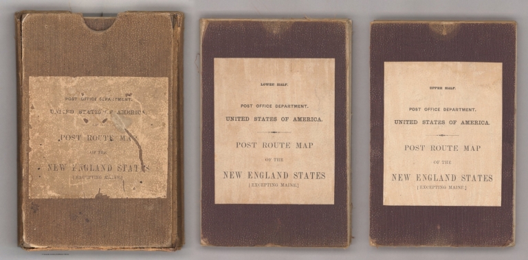
Nicholson, W.L.
Full Title
(Covers to) Post Route Map of the States of New Hampshire, Vermont, Massachusetts, Rhode Island, Connecticut and Parts of New York and Maine. By W.L. Nicholson, Topographer of P.O. Department. 1866. 1873.
List No
12127.001
Note
Light brown cardboard slip cover with label with black text reading, "Post Office Department, United States of America. Post Route Map of the New England States (Excepting Maine)." Two panels on each of the two parts making up the map are backed with cloth and have the above label. One label includes "Upper Half.", the other "Lower Half."
Author
Nicholson, W.L.
Full Title
Post Route Map of the States of New Hampshire, Vermont, Massachusetts, Rhode Island, Connecticut and Parts of New York and Maine. By W.L. Nicholson, Topographer of P.O. Department. 1866. (Northern half). 1873
List No
12127.002
Author
Nicholson, W.L.
Full Title
Post Route Map of the States of New Hampshire, Vermont, Massachusetts, Rhode Island, Connecticut and Parts of New York and Maine. By W.L. Nicholson, Topographer of P.O. Department. 1866. (Southern half). 1873
List No
12127.003
Author
Nicholson, W.L.
Full Title
(Composite Map) Post Route Map of the States of New Hampshire, Vermont, Massachusetts, Rhode Island, Connecticut and Parts of New York and Maine. By W.L. Nicholson, Topographer of P.O. Department. 1866. 1873
List No
12127.004
Author
[Canada Department of the Interior, White, James.]
Full Title
Department of the Interior Canada. Honourable Clifford Sifton, Minister. James A. Smart, Deputy Minister. Map Of The Dominion Of Canada And Newfoundland ... 1902. James White, F.R.G.S, Geographer. Oblique Secant Cylinder Projection. Engraved And Printed By The Toronto Lithographing Co. Limited. Second Edition. November 1902.
List No
15900.000
Author
[Canada Department of the Interior, White, James.]
Full Title
Department of the Interior Canada. Honourable Clifford Sifton, Minister. James A. Smart, Deputy Minister. Map Of The Dominion Of Canada And Newfoundland ... 1902. James White, F.R.G.S, Geographer. Oblique Secant Cylinder Projection. Engraved And Printed By The Toronto Lithographing Co. Limited. Second Edition. November 1902.
List No
15700.000
Author
Johnston. W. & A.K.
Full Title
British North America (Dominion Of Canada And Newfoundland). Constructed From The Recent Government Publications & Other Most Authentic Material By W. & A.K. Johnston, Geographers; Engravers & Printers to the Queen, Edinburgh, And London. 1882. Railways Added To 1893. Engraved & Printed by W. & A.K. Johnston, Edinburgh & London. Entd. Stationers Hall, all right of reproduction reserved.
List No
3943.002
Author
Walker, John
Full Title
(Covers to) This newly constructed and extended map of India from the latest surveys of the best authorities : published principally for the use of the Offices of the Army in India is respectfully inscribed to Major General Sir John Malcolm ... by ... Parbury, Allen, & Compy.
List No
15888.001
Author
Walker, John
Full Title
(North) This newly constructed and extended map of India from the latest surveys of the best authorities : published principally for the use of the Offices of the Army in India is respectfully inscribed to Major General Sir John Malcolm ... by ... Parbury, Allen, & Compy.
List No
15888.002
Author
Walker, John
Full Title
(South) This newly constructed and extended map of India from the latest surveys of the best authorities : published principally for the use of the Offices of the Army in India is respectfully inscribed to Major General Sir John Malcolm ... by ... Parbury, Allen, & Compy.
List No
15888.003
Author
Walker, John
Full Title
(Composite map to) (North and South) This newly constructed and extended map of India from the latest surveys of the best authorities : published principally for the use of the Offices of the Army in India is respectfully inscribed to Major General Sir John Malcolm ... by ... Parbury, Allen, & Compy.
List No
15888.004
Author
[Simon Schropp und Comp., Bembe, W.]
Full Title
(Covers to) Karte der Gewerblichen Verhaltnisse im Europaeischen-Russland mit Angabe der Fabriken und Hutten der Erwerbszweige, der verwaltenden Behorden in Gewerbs- und Handelsangelegenheiten, der vorzuglichsten Marktorter, der Land- und Wasserverbindungen, der Hafen und Leuchtthurme, der Zollamter, der Ladestellen, Quarantainen u.s.w. Nach dem im Jahre 1842 auf Veranstaltung des Kaiserl. Finanz Ministerii erschienenen Russischen Originale, deutsch herausgegeben ; Berlin, bei Simon Schropp & Comp: 1844 ; Gestochen von W. Bembe. (insets) Karte uber die relative Bevolkerung im Europaeischen Russland. (with) Karte uber die Industrii im Moskwaer Gouwernement.
List No
9884.001
Author
[Simon Schropp und Comp., Bembe, W.]
Full Title
Karte der Gewerblichen Verhaltnisse im Europaeischen-Russland mit Angabe der Fabriken und Hutten der Erwerbszweige, der verwaltenden Behorden in Gewerbs- und Handelsangelegenheiten, der vorzuglichsten Marktorter, der Land- und Wasserverbindungen, der Hafen und Leuchtthurme, der Zollamter, der Ladestellen, Quarantainen u.s.w. Nach dem im Jahre 1842 auf Veranstaltung des Kaiserl. Finanz Ministerii erschienenen Russischen Originale, deutsch herausgegeben ; Berlin, bei Simon Schropp & Comp: 1844 ; Gestochen von W. Bembe. (insets) Karte uber die relative Bevolkerung im Europaeischen Russland. (with) Karte uber die Industrii im Moskwaer Gouwernement.
List No
9884.002
Note
Color map on sheet 82x80, dissected into 24 sections, 20.5x13, mounted on linen, folded into marbled green case. Lithographed by W. Bembe. Shows administrative divisions, roads, highways, factories, economic and commercial activities, industry, hydrology, etc. Inset maps showing relative population density in the European Russia and Industry in Moskauer Guvernement. Includes Stamp sticker on map and on cover: No. 54, legend, notes, and explanation.
Author
Devine, Thomas
Full Title
Map of the North West Part of Canada Indian Territories & Hudson's Bay Compiled & Drawn by Thos. Devin Provincial Land Surveyor & Draftsman . . . March, 1857
List No
15873.000
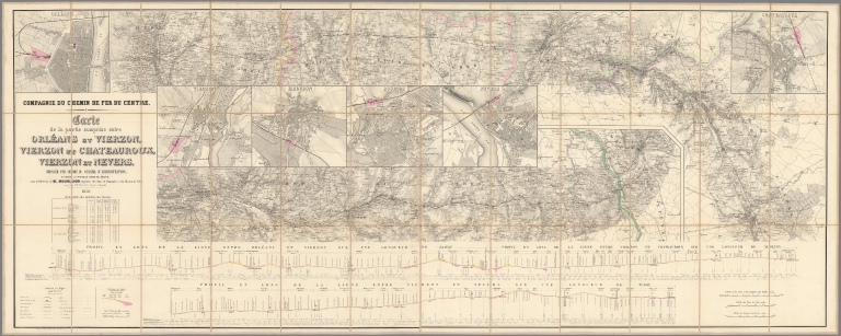
Author
Mourlhon
Full Title
(Covers to) Compagnie du chemin de fer du Centre. Carte de la partie comprise entre Orléans et Vierzon. Vierzon et Châteauroux, Vierzon et Nevers
List No
15871.001
Author
Mourlhon
Full Title
Compagnie du chemin de fer du Centre. Carte de la partie comprise entre Orléans et Vierzon. Vierzon et Châteauroux, Vierzon et Nevers
List No
15871.002
Note
Scale of city plans is 1:10,000
Author
Reichard, C. G.
Full Title
(Sheet 1) Weltcharte in Mercators Projection; von Christian Gottlieb Reichard.
List No
15866.001
Note
Scale is at the Equator.
Author
Reichard, C. G.
Full Title
(Sheet 2) Weltcharte in Mercators Projection; von Christian Gottlieb Reichard.
List No
15866.002
Note
Scale is at the Equator.
Author
Reichard, C. G.
Full Title
(Sheet 3) Weltcharte in Mercators Projection; von Christian Gottlieb Reichard.
List No
15866.003
Note
Scale is at the Equator.
Author
Reichard, C. G.
Full Title
(Sheet 4) Weltcharte in Mercators Projection; von Christian Gottlieb Reichard.
List No
15866.004
Note
Scale is at the Equator.
Author
Reichard, C. G.
Full Title
(Composite map of) (Sheets 1-4) Weltcharte in Mercators Projection; von Christian Gottlieb Reichard.
List No
15866.005
Note
Scale is at the Equator.
Author
Arrowsmith, Aaron
Full Title
Index Sheet 1
List No
15860.001
Note
Index sheet shows the placement of all 18 sheets that make up the map.
Author
Arrowsmith, Aaron
Full Title
Composite: Sheets 1 - 18
List No
15860.019
Author
Arrowsmith, Aaron
Full Title
Sheet 1
List No
15860.002
Author
Arrowsmith, Aaron
Full Title
Sheet 2
List No
15860.003
Author
Arrowsmith, Aaron
Full Title
Sheet 3
List No
15860.004
Author
Arrowsmith, Aaron
Full Title
Sheet 4
List No
15860.005
Author
Arrowsmith, Aaron
Full Title
Sheet 5
List No
15860.006
Author
Arrowsmith, Aaron
Full Title
Sheet 6
List No
15860.007
Author
Arrowsmith, Aaron
Full Title
Sheet 7
List No
15860.008
Author
Arrowsmith, Aaron
Full Title
Sheet 8
List No
15860.009
Author
Arrowsmith, Aaron
Full Title
Sheet 9
List No
15860.010
Author
Arrowsmith, Aaron
Full Title
Sheet 10
List No
15860.011
Author
Arrowsmith, Aaron
Full Title
Sheet 11
List No
15860.012
Author
Arrowsmith, Aaron
Full Title
Sheet 12
List No
15860.013
Author
Arrowsmith, Aaron
Full Title
Sheet 13 and 16
List No
15860.014
Author
Arrowsmith, Aaron
Full Title
Sheet 14
List No
15860.015
Author
Arrowsmith, Aaron
Full Title
Sheet 15
List No
15860.016
Author
Arrowsmith, Aaron
Full Title
Sheet 17
List No
15860.017
Author
Arrowsmith, Aaron
Full Title
Sheet 18
List No
15860.018
Author
[Garlato, Giambattista, Kier, Giuseppe]
Full Title
Pianta della regia citta di Venezia e sue isole vicine. Pubblicata da Giuseppe Kier ... dis. et incisa da Giambatti ta Garlato ..
List No
15823.000
Author
[Beardshaw, John, Leonard, C.W.]
Full Title
(Covers to) Bacon's Chronological and Geographical Family Guide to The Holy Bible.
List No
15795.001
Author
[Beardshaw, John, Leonard, C.W.]
Full Title
Bacon's Chronological and Geographical Family Guide to The Holy Bible.
List No
15795.002
Author
Chatelain, Anatole Julien (1817 - 1898)
Full Title
(Covers to) Carte des voies de communication établies dans le Monde entier, au moyen de la vapeur et de l'électricité; "World's Steam and Electric Map" Avec indications des Postes Consulaires de France sur le Globe dressée d’après les documents officiels très récents par Anatole Chatelain Ex-Chef du Bureau de la Statistique au Ministère des Affaires Étrangères et dédiée a S.M. l’Empereur.
List No
15798.001
Author
Chatelain, Anatole Julien (1817 - 1898)
Full Title
Carte des voies de communication établies dans le Monde entier, au moyen de la vapeur et de l'électricité; "World's Steam and Electric Map" Avec indications des Postes Consulaires de France sur le Globe dressée d’après les documents officiels très récents par Anatole Chatelain Ex-Chef du Bureau de la Statistique au Ministère des Affaires Étrangères et dédiée a S.M. l’Empereur.
List No
15798.002
Author
Anonymous
Full Title
Erzurum, Van, Bitlis vilâyetleri ile bunlara civar olan Trabzon, Sivas, Harput, Diyarbekir, Musul vilâyetlerinin bâzi kisâmi [i.e., The map of Erzurum, Van, Bitlis vilayats and adjacent to these places such as Trabzon, Sivas, Harput, Diyarbakir and Musul].
List No
15790.000
Note
Date estimated.
Author
Arrowsmith, Aaron
Full Title
(Sheet 1) Map of the Province of Malabar, Drawn from Various Surveys By A. Arrowsmith
List No
15782.001
Author
Arrowsmith, Aaron
Full Title
(Sheet 2) Map of the Province of Malabar, Drawn from Various Surveys By A. Arrowsmith
List No
15782.002
Author
Arrowsmith, Aaron
Full Title
(Sheet 3) Map of the Province of Malabar, Drawn from Various Surveys By A. Arrowsmith
List No
15782.003
Author
Arrowsmith, Aaron
Full Title
(Composite map of) (Sheets 1-3) Map of the Province of Malabar, Drawn from Various Surveys By A. Arrowsmith
List No
15782.004
Author
[Bureau de L'Atlas National, Cassini, Cesar-Francois, 1714-1784]
Full Title
(Covers to) France Departementale (From Cover)
List No
15641.001
Author
Bureau de L'Atlas National
Full Title
172. Department Du Finisterre Atlas National De France.
List No
15641.002
Author
Bureau de L'Atlas National
Full Title
35. Department De La Moselle. Atlas National De France.
List No
15641.003
Author
Bureau de L'Atlas National
Full Title
78. Department De La Haute Vienne.
List No
15641.004
Author
Bureau de L'Atlas National
Full Title
101. Department De La Charente.
List No
15641.005
Author
Bureau de L'Atlas National
Full Title
9. Department Des Ardennes.
List No
15641.006
Author
Bureau de L'Atlas National
Full Title
40. Department De La Charente Inferieure.
List No
15641.007
Author
Bureau de L'Atlas National
Full Title
84. Department De La Seine
List No
15641.008
Author
Anonymous
Full Title
(Troyes)
List No
15641.009
Author
Cassini, Cesar-Francois, 1714-1784
Full Title
80 Chalons-en-Champagne.
List No
15641.010
Author
Cassini, Cesar-Francois, 1714-1784
Full Title
(45 Meaux)
List No
15641.011
Author
Cassini, Cesar-Francois, 1714-1784
Full Title
(No. 26 Evreux - Dreux. 1781)
List No
15641.012
Author
Cassini, Cesar-Francois, 1714-1784
Full Title
111. Toul
List No
15641.013
Author
Cassini, Cesar-Francois, 1714-1784
Full Title
No. 79 (Reims. 1760)
List No
15641.014
Author
Cassini, Cesar-Francois, 1714-1784
Full Title
(Covers to) No. 81 (Troyes. 1758, corr. 1760)
List No
15656.001
Author
Cassini, Cesar-Francois, 1714-1784
Full Title
No. 81 (Troyes. 1758, corr. 1760)
List No
15656.002
Note
See our 5694.102 for a similar issue.
Author
Cassini, Cesar-Francois, 1714-1784
Full Title
No. 112 (Joinville. 1763)
List No
15656.003
Note
See our 5694.135 for a similar issue.
Author
Cassini, Cesar-Francois, 1714-1784
Full Title
Composite: No. 81 (Troyes) and No. 112 (Joinville. 1763)
List No
15656.004
Author
Impr. Kappelin
Full Title
(Covers to) Province De Constantine (Feuille 1ere.)
List No
15655.001
Author
Impr. Kappelin
Full Title
Province De Constantine (Feuille 1ere.)
List No
15655.002
Author
Impr. Kappelin
Full Title
Province De Constantine (Feuille 2e..)
List No
15655.003
Author
Impr. Kappelin
Full Title
(Composite map to) Province De Constantine (Feuilles 1ere.& 2 e.)
List No
15655.004
Author
Andriveau-Goujon, E. (Eugène), 1832-1897
Full Title
(Covers to) Carte de l'Europe Orientale comprenant la Russie d'Europe L'Empire Ottoman et la Grèce. Paris, E. Andriveau-Goujon, éditeur, 21 Rue du Bac, 1860.
List No
15648.001
Author
Andriveau-Goujon, E. (Eugène), 1832-1897
Full Title
Carte de l'Europe Orientale comprenant la Russie d'Europe L'Empire Ottoman et la Grèce. Paris, E. Andriveau-Goujon, éditeur, 21 Rue du Bac, 1860.
List No
15648.002
Author
Andriveau-Goujon, E. (Eugène), 1832-1897
Full Title
(Covers to) Empire Ottoman. Publie Par E. Andriveau-Goujon Rue Du Bac, 21 Paris 1860. Gravé le trait par Smith; la topographie par Gérin; les escritures par P. Rousset; les eaux par Mme. Fontaine
List No
15657.001
Author
Andriveau-Goujon, E. (Eugène), 1832-1897
Full Title
Empire Ottoman. Publie Par E. Andriveau-Goujon Rue Du Bac, 21 Paris 1860. Gravé le trait par Smith; la topographie par Gérin; les escritures par P. Rousset; les eaux par Mme. Fontaine
List No
15657.002
Author
Andriveau-Goujon, E. (Eugène), 1832-1897
Full Title
(Composite map of) (North half and Southern half) Carte de l'Europe Orientale comprenant la Russie d'Europe L'Empire Ottoman et la Grèce. Paris, E. Andriveau-Goujon, éditeur, 21 Rue du Bac, 1860. Gravé le trait par Smith; la topographie par Gérin; les escritures par P. Rousset; les eaux par Mme. Fontaine
List No
15746.000
Author
Andriveau-Goujon, E. (Eugène), 1832-1897
Full Title
(Covers to) Asie méridionale comprenant la Presqu'Ile de l'Inde, la Perse, l'Afghanistan et le Beloutchistan. Paris, 1860, E. Andriveau-Goujon, éditeur. Rue du Bac, 21 Gravé: le trait par Smith; les montagnes par Gérin; les ecritures par P. Rousset; les eaux par Mme. Fontaine; Dressee par A. Vuillemin.
List No
15647.001
Author
Andriveau-Goujon, E. (Eugène), 1832-1897
Full Title
Asie méridionale comprenant la Presqu'Ile de l'Inde, la Perse, l'Afghanistan et le Beloutchistan. Paris, 1860, E. Andriveau-Goujon, éditeur. Rue du Bac, 21 Gravé: le trait par Smith; les montagnes par Gérin; les ecritures par P. Rousset; les eaux par Mme. Fontaine; Dressee par A. Vuillemin.
List No
15647.002
Author
Andriveau-Goujon, E. (Eugène), 1832-1897
Full Title
(Covers to) États Scandinaves. Paris, E. Andriveau-Goujon, éditeur, 1860, Rue du Bac, 21 . Gravé le trait par Smith; la topographie par Gérin; les escritures par P. Rousset; les eaux par Mme. Fontaine, Paris, Impie. de Chardon Jeune.
List No
15649.001
Author
Andriveau-Goujon, E. (Eugène), 1832-1897
Full Title
États Scandinaves. Paris, E. Andriveau-Goujon, éditeur, 1860, Rue du Bac, 21 . Gravé le trait par Smith; la topographie par Gérin; les escritures par P. Rousset; les eaux par Mme. Fontaine, Paris, Impie. de Chardon Jeune.
List No
15649.002
Author
Andriveau-Goujon, E. (Eugène), 1832-1897
Full Title
(Covers to) Iles Britanniques. Paris, 1860, E. Andriveau-Goujon, éditeur, Rue du Bac, 21. Paris, Impie. de Louis Antoine, Rue des Noyers, 70; gravé le trait par Smith; les montagnes par Gérin; les escritures par P. Rousset; les eaux par Mme. Fontaine.
List No
15651.001
Author
Andriveau-Goujon, E. (Eugène), 1832-1897
Full Title
Iles Britanniques. Paris, 1860, E. Andriveau-Goujon, éditeur, Rue du Bac, 21. Paris, Impie. de Louis Antoine, Rue des Noyers, 70; gravé le trait par Smith; les montagnes par Gérin; les escritures par P. Rousset; les eaux par Mme. Fontaine.
List No
15651.002
Author
Andriveau-Goujon, J.
Full Title
(Covers to) Carte Physique & Routiere De L'Italie (Northern half)
List No
15654.001
Author
Andriveau-Goujon, J.
Full Title
Carte Physique & Routiere De L'Italie (Northern half)
List No
15654.002
Author
Andriveau-Goujon, E. (Eugène), 1832-1897
Full Title
(Covers to) Italie. Paris 1860. E. Andriveau-Goujon, éditeur, Rue du Bac, 21. Gravé le trait par Smith; la topographie par Gérin; les escritures par P. Rousset; les eaux par Mme. Fontaine
List No
15658.001
Author
Andriveau-Goujon, E. (Eugène), 1832-1897
Full Title
Italie. Paris 1860. E. Andriveau-Goujon, éditeur, Rue du Bac, 21. Gravé le trait par Smith; la topographie par Gérin; les escritures par P. Rousset; les eaux par Mme. Fontaine
List No
15658.002
Author
Andriveau-Goujon, E. (Eugène), 1832-1897
Full Title
(Covers to) Navigation à vapeur dans le bassin de Méditerranée et chemins de der de 'Europe centrale. Publiée par E. Andriveau-Goujon, Rue du Bac, 21. Paris, 1860, Impie. de Louis Antoine; le trait gravé par Smith; les escritures par P. Rousset.
List No
15659.001
Author
Andriveau-Goujon, E. (Eugène), 1832-1897
Full Title
Navigation à vapeur dans le bassin de Méditerranée et chemins de der de 'Europe centrale. Publiée par E. Andriveau-Goujon, Rue du Bac, 21. Paris, 1860, Impie. de Louis Antoine; le trait gravé par Smith; les escritures par P. Rousset.
List No
15659.002
Author
Rocque, John
Full Title
(Covers to( The Traveller's Companion or the Post Roads of England and Wales.
List No
15723.001
Author
Rocque, John
Full Title
The Traveller's Companion or the Post Roads of England and Wales.
List No
15723.002
Author
Stanford's Geographical Establishment
Full Title
Stanford's Two Inch Map of London and its environs. Municipal edition.
List No
15722.001
Note
Date estimated.
Author
Stanford's Geographical Establishment
Full Title
(Covers to) Stanford's Two Inch Map of London and its environs. Municipal edition.
List No
15722.002
Note
Date estimated.
Author
[Edwards, Archer, J.]
Full Title
New Plan of London.
List No
15720.000
Author
Andriveau-Goujon, E. (Eugène), 1832-1897
Full Title
(Covers to) Carte générale de l'Afrique d'après les derraeres découvertes. Publiée par E. Andriveau-Goujon, 21, Rue du Bac, Paris, 1860. Gravée par Smith et Gérin; les ecritures par P. Rousset.
List No
15640.001
Note
Hand-colored, engraved map of Africa, showing showing political boundaries, roads and railroads (on double plate with decorative border). Includes legend indicating colonies (English, French, Spanish, Portuguese and of the Sultan of Zanzibar), as well as 5 bar scales. "No. 20" in upper right. With 8 insets: (Iles Canaries) -- (Madère) -- (Iles du Cap Vért) -- (Ile de l'Ascension) -- (Ile Ste. Hélène) -- (Ile Mayotte) -- (Iles Nossi-Be) -- (Iles Mascareignes).
Author
Andriveau-Goujon, E. (Eugène), 1832-1897
Full Title
Carte générale de l'Afrique d'après les derraeres découvertes. Publiée par E. Andriveau-Goujon, 21, Rue du Bac, Paris, 1860. Gravée par Smith et Gérin; les ecritures par P. Rousset.
List No
15640.002
Note
Hand-colored, engraved map of Africa, showing showing political boundaries, roads and railroads (on double plate with decorative border). Includes legend indicating colonies (English, French, Spanish, Portuguese and of the Sultan of Zanzibar), as well as 5 bar scales. "No. 20" in upper right. With 8 insets: (Iles Canaries) -- (Madère) -- (Iles du Cap Vért) -- (Ile de l'Ascension) -- (Ile Ste. Hélène) -- (Ile Mayotte) -- (Iles Nossi-Be) -- (Iles Mascareignes).
Author
Andriveau-Goujon, E.
Full Title
Carte Generale Des Etats - Unis Et Du Mexique Comprenant L'Amerique Centrale Et Les Antilles. E. Andriveau-Goujon, Editeur. Paris, Rue Du Bac, 21. 1860. Dressee par A. Vuillemin ... (with four inset maps).
List No
15650.000
Author
[Petkovic, Dr. Kosta V., Geološki Institut Kraljevine Jugoslavije]
Full Title
Geoloika karts Kraljevine Jugoslavije / Carte geologique du Royaume de Jugoslavie
List No
15708.000
Author
Imperial Regio Istituto Geografico Militare
Full Title
(Covers to) Carta Topografica del Ducato di Modena
List No
15667.001
Author
Imperial Regio Istituto Geografico Militare
Full Title
I. - II. Carta Topografica del Ducato di Modena
List No
15667.002
Note
Sheets I. and II. are mounted together on this sheet.
Author
Imperial Regio Istituto Geografico Militare
Full Title
III. Carta Topografica del Ducato di Modena
List No
15667.003
Author
Imperial Regio Istituto Geografico Militare
Full Title
IV. Carta Topografica del Ducato di Modena
List No
15667.004
Author
Imperial Regio Istituto Geografico Militare
Full Title
V. Carta Topografica del Ducato di Modena
List No
15667.005
Author
Imperial Regio Istituto Geografico Militare
Full Title
VI. Carta Topografica del Ducato di Modena
List No
15667.006
Author
Imperial Regio Istituto Geografico Militare
Full Title
VII. Carta Topografica del Ducato di Modena
List No
15667.007
Author
Imperial Regio Istituto Geografico Militare
Full Title
VIII. Carta Topografica del Ducato di Modena
List No
15667.008
Author
Imperial Regio Istituto Geografico Militare
Full Title
(Composite map of) I. - VIII. Carta Topografica del Ducato di Modena
List No
15667.009
Author
Istituto Geografico Militare
Full Title
(Covers to) Carta Topografica dei Ducati di Parma, Piacenza e Guastalla levata dietro misure trigonometriche negli anni 1821-1822 sotto il Governo di Sua Maestà L'Arciduchessa Maria Luigia
List No
15702.001
Author
Istituto Geografico Militare
Full Title
I. Carta Topografica dei Ducati di Parma, Piacenza e Guastalla levata dietro misure trigonometriche negli anni 1821-1822 sotto il Governo di Sua Maestà L'Arciduchessa Maria Luigia
List No
15702.002
Author
Istituto Geografico Militare
Full Title
II. Carta Topografica dei Ducati di Parma, Piacenza e Guastalla levata dietro misure trigonometriche negli anni 1821-1822 sotto il Governo di Sua Maestà L'Arciduchessa Maria Luigia
List No
15702.003
Author
Istituto Geografico Militare
Full Title
III. Carta Topografica dei Ducati di Parma, Piacenza e Guastalla levata dietro misure trigonometriche negli anni 1821-1822 sotto il Governo di Sua Maestà L'Arciduchessa Maria Luigia
List No
15702.004
Author
Istituto Geografico Militare
Full Title
IV. Carta Topografica dei Ducati di Parma, Piacenza e Guastalla levata dietro misure trigonometriche negli anni 1821-1822 sotto il Governo di Sua Maestà L'Arciduchessa Maria Luigia
List No
15702.005
Author
Istituto Geografico Militare
Full Title
V. Carta Topografica dei Ducati di Parma, Piacenza e Guastalla levata dietro misure trigonometriche negli anni 1821-1822 sotto il Governo di Sua Maestà L'Arciduchessa Maria Luigia
List No
15702.006
Author
Istituto Geografico Militare
Full Title
VI. Carta Topografica dei Ducati di Parma, Piacenza e Guastalla levata dietro misure trigonometriche negli anni 1821-1822 sotto il Governo di Sua Maestà L'Arciduchessa Maria Luigia
List No
15702.007
Author
Istituto Geografico Militare
Full Title
VII. Carta Topografica dei Ducati di Parma, Piacenza e Guastalla levata dietro misure trigonometriche negli anni 1821-1822 sotto il Governo di Sua Maestà L'Arciduchessa Maria Luigia
List No
15702.008
Author
Istituto Geografico Militare
Full Title
VIII. Carta Topografica dei Ducati di Parma, Piacenza e Guastalla levata dietro misure trigonometriche negli anni 1821-1822 sotto il Governo di Sua Maestà L'Arciduchessa Maria Luigia
List No
15702.009
Author
Istituto Geografico Militare
Full Title
IX. Carta Topografica dei Ducati di Parma, Piacenza e Guastalla levata dietro misure trigonometriche negli anni 1821-1822 sotto il Governo di Sua Maestà L'Arciduchessa Maria Luigia
List No
15702.010
Author
Istituto Geografico Militare
Full Title
(Composite map of) I. - IX. Carta Topografica dei Ducati di Parma, Piacenza e Guastalla levata dietro misure trigonometriche negli anni 1821-1822 sotto il Governo di Sua Maestà L'Arciduchessa Maria Luigia
List No
15702.011
Author
Andriveau-Goujon, E. (Eugène), 1832-1897
Full Title
(Covers to) Suisse d'après l'État-Major Fédéral et les nouvelles cartes cantonales. Paris, 1860, E. Andriveau-Goujon, éditeur, Rue du Bac, 21 . Imp. Ch. Chardon ainé; gravé: le trait par Smith; la topographie par Gérin; les ecritures par P. Rousset; les eaux par Mme. Fontaine.
List No
15652.001
Note
Hand-colored, engraved map of Switzerland, showing showing political boundaries, roads and railroads (on double plate with decorative border). Includes legend, as well as 4 bar scales and a scale statement. "No. 10" in upper right. "Atlas universel, No. 23" in upper left. See our 14008.014 for the 1880 version of this map. Manuscript additions throughout, including a red set of grid lines.
Author
Andriveau-Goujon, E. (Eugène), 1832-1897
Full Title
Suisse d'après l'État-Major Fédéral et les nouvelles cartes cantonales. Paris, 1860, E. Andriveau-Goujon, éditeur, Rue du Bac, 21 . Imp. Ch. Chardon ainé; gravé: le trait par Smith; la topographie par Gérin; les ecritures par P. Rousset; les eaux par Mme. Fontaine.
List No
15652.002
Note
Hand-colored, engraved map of Switzerland, showing showing political boundaries, roads and railroads (on double plate with decorative border). Includes legend, as well as 4 bar scales and a scale statement. "No. 10" in upper right. "Atlas universel, No. 23" in upper left. See our 14008.014 for the 1880 version of this map. Manuscript additions throughout, including a red set of grid lines.
Author
Kaeppelin, E.
Full Title
(Covers to) Carte Pour servir à l'intelligence Des Opérations Du Corps De La Moselle : Sous les ordres De Son Altesse Royale Monseigneur Le Duc De Nemours
List No
15653.001
Author
Kaeppelin, E.
Full Title
Carte Pour servir à l'intelligence Des Opérations Du Corps De La Moselle : Sous les ordres De Son Altesse Royale Monseigneur Le Duc De Nemours
List No
15653.002
|
![Karta glavneishikh lechebnykh mest Evropy [Map of Major Healing Places in Europe].](https://www.davidrumsey.com/rumsey/Size2/RUMSEY~8~1/213/15953000.jpg)


![Erzurum, Van, Bitlis vilâyetleri ile bunlara civar olan Trabzon, Sivas, Harput, Diyarbekir, Musul vilâyetlerinin bâzi kisâmi [i.e., The map of Erzurum, Van, Bitlis vilayats and adjacent to these places such as Trabzon, Sivas, Harput, Diyarbakir and Musul].](https://www.davidrumsey.com/rumsey/Size2/RUMSEY~8~1/205/15790000.jpg)