|
REFINE
Browse All : Book Map from 1797
1-4 of 4
Author
Imlay, Gilbert
Full Title
A Map of The Western Part of the Territories belonging to the United States of America. Drawn from the best Authorities. Engraved for Imlay's Topographical Description of that Country. T. Conder Sculpt. Published June 1st 1795, by J. Debrett, Picadilly, London.
List No
2757.001
Note
Territories shown in outline color. Map stretches from the top of the Great Lakes to southern Georgia. Battles, settlements, and forts are noted.
Author
Imlay, Gilbert
Full Title
A Plan of the Rapids of the Ohio. T. Conder, Sculpt. Engraved for Imlay's American Topography. Published Feby. 1st, 1793, by J. Debrett, Piccadilly, London.
List No
2757.002
Note
Uncolored highly detailed map of the Ohio River rapids with Clarkville on one side of the river and Louisville on the other. Houses, gardens, crop fields, a fort, roads and the rapids are shown.
Author
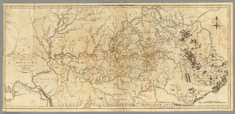
Imlay, Gilbert
Full Title
A Map of the State of Kentucky, from Actual Survey by Elihu Barker of Philadelphia. T. Conder Sculpt. London, Published June 1st, 1795 by J. Debrett, PIccadilly.
List No
2757.003
Note
Uncolored map with detailed information about the state including county lines, rivers, mountains, roads, rapids on the river, and geography of the land.
Author
Imlay, Gilbert
Full Title
A Map of the Tennassee Government, formerly part of North Carolina, taken chiefly from Surveys by Genel. D. Smith & others. T. Conder Sculpt. Engraved for Imlay's American Topography. London, Published June 1st, 1795, by J. Debrett, Piccadilly.
List No
2757.004
Note
Uncolored map of the state showing rivers (with their widths), mountains, Indian boundaries, and towns.
1-4 of 4
|