|
REFINE
Browse All : Atlas Map of United States and California
1-38 of 38
Author
[Berghaus, Heinrich, 1797-1884, Sohr, Karl, Flemming, Carl]
Full Title
Californien, Oregon, Utah und Neu-Mejico. Entw. u. gez. v. F. Handtke. Druck u. Verlag v. C. Flemming in Glogau. (to accompany) Vollstandiger Universal-Handatlas der neueren Erdbeschreibung ,,, Heinrich Berghaus ... 1859.
List No
13250.128
Note
Hand colored in outline map. Includes color coded list of administrative boundaries. Relief shown by hachures. Prime meridians are Paris and Ferro.
Author
[Meyer, Joseph, 1796-1856, Grassl, J.]
Full Title
Vereinigte Staaten von Nord-America : Californien, Texas und die Territorien New Mexico u. Utah. Nach den neuesten Hulfsmitteln gezeich von J. Grassl. 1852. (in upper margin) Meyer's Zeitung Atlas. No. 120. (to accompany) Neuester Zeitungs-Atlas fur Alte und Neue Erdkunde. Herausgegeben von J. Meyer.
List No
11652.098
Note
Engraved outline hand color map. Shows administrative boundaries, cities and towns, the gold region in California, Texas truncated by an enlarged New Mexico. Relief shown by hachures. Depth shown by isolines. Prime meridians are Greenwich and Washington.
Author
[Bartholomew, John, Black, Adam & Charles]
Full Title
Western States, including California, Oregon, Utah, Washington, New Mexico, Nebraska, Kansas, Indian Territory, &c. Published by A. & C. Black. Edinburgh. Printed in Colours by Schenck & Macfariane. Edinburgh. Drawn & Engraved by J. Bartholomew, Edinburgh.
List No
0073.018
Note
States outlined in color. Land tinted.
Author
Mitchell, Samuel Augustus Jr.
Full Title
County map of California (inset maps) 52. Map of the Settlements in the Great Salt Lake Country. Utah. 53. San Francisco Bay and Vicinity. Entered ... 1867 by S. Augustus Mitchell, Jr. ... Pennsylvania.
List No
0579.043
Note
Color map by county. Relief shown by hachures. Prime meridians are Greenwich and Washington, D.C.
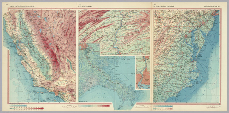
Author
Polish Army Topography Service
Full Title
United States of America - California. U.S.A. - Selected Areas. Atlantic Coastal Plain - Central. Pergamon World Atlas. Pergamon Press, Ltd. & P.W.N. Poland 1967. Sluzba Topograficzna W.P.
List No
0737.208
Note
Detailed physical and political regional maps: California at 1:2,500,000; New Orleans and Central Appalachians at 1:500,000; Niagara at 1:100,000; Central Atlantic Coastal Plain at 1: 2,500,000.
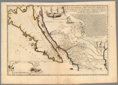
Author
Fer, Nicolas de, 1646-1720
Full Title
La Californie ou Nouvelle Caroline, teatro de los trabajos, apostolicos de la Compa. e Jesus en la America Septe. : Dresse��e sur celle que la viceroy de la Nouvelle Espagne envoya ily a peu d'anne��es a mrs. de l'Acade��mie des Sciences
List No
10022.102
Note
Shows California as an island.
Author
Bröuckner, Isaak, 1686-1762.
Full Title
Carte marine entre Californie et une partie de l'Asie la plus orientale. 1749. (to accompany) Nouvel Atlas De Marine... Par Isaac Brouckner ... Approuve par l’ academie Royale des Sciences a Berlin l’ Annee 1749.
List No
13388.009
Note
Hand colored in outline nautical chart between California and part of eastern Asia.
Author
Stieler, Adolf, 1775–1836
Full Title
Petermann : Vereinigte Staaten Von Nord-Amerika In 6 Blattern, Bl. 1. Bearbeitet v. H. Habenicht. Gest v. Metzeroth, Eberhardt, Kramer. Stieler's Hand-Atlas No. 81. Gotha: Justus Perthes. 1875.
List No
13563.104
Note
1 outline color map on 6 sheets. Sheet 1. Title from sheet 4. shows Pacific Northwest, and parts of Montana, Wyoming, Utah, Nevada, and California.
Author
Stieler, Adolf, 1775–1836
Full Title
Die Vereinigten Staaten Von Nord-Amerika In 6 Blattern. Von A. Petermann. Bearbeitet v. H. Habenicht. Gest v. Eberhardt, Kuhn, Metzeroth & Weiler. Stieler's Hand-Atlas No. 84. Gotha: Justus Perthes. 1875.
List No
13563.107
Note
1 outline color map on 6 sheets. Sheet 4. Title from sheet 4. Shows Arizona, Part of California, Nevada, Utah, Colorado, New Mexico, and northern Mexico.
Author
[3, Soviet Union. Glavnoe upravlenie geodezii i kartografii]
Full Title
Калифорния = Kaliforniia. 244. Atlas Mira : 1954.
List No
13682.257
Note
Map of California. Relief shown by shadings, contours and spot heights. Depths shown by gradient tints, isolines and soundings.
Author
[Československá akademie věd., Klíma, Jan]
Full Title
Spojené Státy Amerika. Československý vojenský atlas̊.
List No
13684.159
Note
5 maps on 1 sheet. Including: Aleutian Islands (Alaska) , Hawaiian Islands, San Francisco and surroundings, Los Angeles and San Francisco and Oakland. Relief shown by gradient tints, hachures and spot heights. Depth shown by bathymetric tints, isolines and soundings.
Author
Rand McNally and Company
Full Title
Rand, McNally & Co.'s California. (with) (San Francisco Bay Area).
List No
2094.056
Note
Counties outlined in color. Railroads highlighted. Relief shown by hachures. One inset.
Author
Rand McNally and Company
Full Title
Rand, McNally & Co.'s California. (with) (Los Angeles and vicinity). (with) (San Francisco Bay Area).
List No
2844.077
Note
Tables of railroads and chief cities keyed to map.
Author
Mitchell, Samuel Augustus.
Full Title
Oregon and Upper California. Published By S. Augustus Mitchell, N.E. corner of Market & 7th Streets. Philadelphia. 1848. Entered ... 1845, by H.N. Burroughs ... Pennsylvania. (to accompany) A New Universal Atlas Containing Maps of the various Empires, Kingdoms, States and Republics Of The World.
List No
3697.040
Note
Color copper lithograph map of Oregon and Upper or New California. Except for date, map appears identical to 1847 edition, but with the Mexican boundary line added in red ink. Coverage is extended eastward to include New Mexico and part of Missouri Territory, New California extends to the Gulf of California. Shows boundaries, Native American settlements, important towns, lakes, mountains and rivers. includes descriptive notes. Prime meridians are Greenwich and Washington. Relief shown by hachures. Not included in table of contents.
Author
Mitchell, Samuel Augustus.
Full Title
Mexico & Geuatemala. Published By S. Augustus Mitchell, N.E. corner of Market & 7th Streets. Philada. 1848. Entered ... 1846, by H.N. Burroughs ... Pennsylvania. (to accompany) A New Universal Atlas Containing Maps of the various Empires, Kingdoms, States and Republics Of The World. (insets) Guatemala. (with) Valley of Mexico.
List No
3697.041
Note
Color copper lithograph map by state or region. Covers Upper or New California and extended to Texas and part of Louisiana. Shows boundaries, Native American settlements, capitals, important towns, mines, Battle fields, mountains and rivers. includes descriptive notes and explanations. Prime meridians are Greenwich and Washington. Relief shown by hachures.
Author
[Warner, Higgins & Beers, Lloyd, H.H.]
Full Title
Atlas of the United States. Map of Nevada and California. Warner, Higgins & Beers Publishers. 1871. From H. H. Lloyd & Co.,s. Atlas of the United States. (to accompany) Atlas of the State of Illinois To Which Is Added An Atlas Of The United States Maps of The Hemispheres &c. &c. &c. Warner, Higgins & Beers Publishers. 143 Clark St. Chicago. 1871.
List No
3749.043
Note
Outline hand colored lithographed map. Showing state and county boundaries, cities, towns, rivers, roads and railroads. Relief shown by hachures. Prime meridians are Washington, D.C. and Greenwich.
Author
National Map Company
Full Title
California. (Copyrighted by) National Map Company, Indianapolis. (to accompany) Official Paved Road and Commercial Survey of the United States. ( with 2 insets).
List No
4048.053
Note
Outline color map on 2 sheets. Insets showing maps of Northern and Southern California. Shows administrative divisions, roads, rivers, etc. Relief shown by hachures. Prime meridian is Greenwich.
Author
[Morse, Sidney E. (Sidney Edwards), 1794-1871, Breese, S.]
Full Title
Map of the Californias; by T.J. Farnham. (to accompany) Supplement To The New-York Observer. The Cerographic Atlas Of The United States. No.3. 1845. Entered ... 1845, by Sidney E. Morse and Samuel Breese ... New-York.
List No
4180.034
Note
Uncolored map. Shows settlements, roads, railroads, rivers, missions, Farnham and Dr, Lyman's routes, etc. Relief shown by hachures. Prime meridians are Greenwich and Washington.
Author
Lloyd, H.H.
Full Title
County map of California and Nevada. County map of Arizona and Southern California. (to accompany) Lloyd's Handy Atlas ... Published By D.L. Guernsey, Concord, N.H. 1874. Entered ... 1872, by H.H. Lloyd, & Co. ... Washington.
List No
4474.025
Note
2 outline hand colored maps. Showing administrative boundaries, numerous cities, railroads, roads, rivers, and mountains. Relief shown by hachures. Prime meridians are Greenwich and Washington.
Author
[Bourquin, Frederick, Mitchell, Samuel Augustus, Tanner, Henry S.]
Full Title
Oregon, Upper California & New Mexico. Published by S. Augustus Mitchell, N.E. Corner of Market & 7th. Streets Philadelphia. 1849. Entered according to Act of Congress in the 1845 by H.N. Burroughs - in the Clerk's Office of the Eastern District of Penna. 36.
List No
4578.037
Note
Revision of Mitchell's 1846-1847 maps with title: Oregon and Upper California. Coverage is extended eastward to include New Mexico and part of Missouri Territory. Mexican boundary added. Relief shown by hachures and spot heights. Uncolored. "Oregon" and "Upper or New California" in bold type. Shows Indian tribes and includes descriptive notes. New California extends to the Gulf of California. Prime meridians: Greenwich and Washington. Lithographed. Trails, roads, and rivers shown. Shows the Great Spanish Trail, Oregon Route and Lewis and Clark's Route.
Author
Becker, George F.
Full Title
Geological Map of the Sulphur Bank District. U.S. Geological Survey. Monograph XIII, Atlas Sheet IV. S.H. Bodfish 1882, J.D. Hoffman 1884, Topographers. Giles Litho. & Liberty Printing Co. Geo. F. Becker, Geologist in charge.
List No
4580.002
Note
Shows in color three classes of rock. Relief shown by 20-foot contour lines. Shows mines, streams, and settlements.
Author
Becker, George F.
Full Title
Geological Map of the Knoxville District. U.S. Geological Survey. Monograph XIII, Atlas Sheet V. Topography by J.D. Hoffman 1883. Geo. F. Becker, Geologist in charge. Topographical Map of the Region of Clear Lake. Compiled by C.F. Hoffmann. Geo. F. Becker, Geologist in charge.
List No
4580.003
Note
Two maps on one sheet. Knoxville District map relief shown with 25-foot contours. Shows in color five classes of rock. Longitude and latitude shown. Scale 1:15,000. Clear Lake Region map shows topography with shaded relief, streams, mines, settlements, and roads. Scale 1:95,000. Outlines of Sulphur Bank District and Knoxville District shown.
Author
Becker, George F.
Full Title
Geological Map of the New Idria District. U.S. Geological Survey. Monograph XIII, Atlas Sheet VI. J.D. Hoffman, Topographer. Giles Litho. & Liberty Printing Co. N.Y. Geo. F. Becker, Geologist in charge.
List No
4580.004
Note
Shows in color three classes of rock. Relief shown by 40-foot contour lines. Shows streams, settlements, mines, trails, and roads.
Author
Becker, George F.
Full Title
Geological Map of the New Almaden Mining District. U.S. Geological Survey. Monograph XIII, Atlas Sheet VII. Topography by S.W. Bodfish and others. Giles Litho. & Liberty Printing Co. N.Y. Geo. F. Becker, Geologist in charge.
List No
4580.005
Note
Shows in color six classes of rock. Relief shown by 20-foot contour lines. Shows streams, settlements, mines, and roads.
Author
Becker, George F.
Full Title
Ore-Bodies and Topography of Mine-Hill, New Almaden. U.S. Geological Survey. Monograph XIII, Atlas Sheet VIII. Compiled by F. Reade 1885. Giles Litho. & Liberty Printing Co. N.Y. Geo. F. Becker, Geologist in charge.
List No
4580.006
Note
Shows in topography with 10-foot contours, ore bodies with cross-hatching, mine dumps with hachures, +streams, roads, tramways, tunnels and shafts.
Author
Becker, George F.
Full Title
Plan of the New Almaden Mine. U.S. Geological Survey. Monograph XIII, Atlas Sheet IX. Compiled by F. Reade 1885. Giles Litho. & Liberty Printing Co. N.Y. Geo. F. Becker, Geologist in charge.
List No
4580.007
Note
Shows depths, tunnels, drifts, galleries, and shafts in brilliant color.
Author
Becker, George F.
Full Title
Longitudinal Section of the South Ore Channel. New Almaden Mine. U.S. Geological Survey. Monograph XIII, Atlas Sheet X. Compiled by F. Reade 1885. Giles Litho. & Liberty Printing Co. N.Y. Geo. F. Becker, Geologist in charge.
List No
4580.008
Note
Shows depths, tunnels, drifts, galleries, and shafts.
Author
Becker, George F.
Full Title
North and South Section , 550 Feet West of Randol Shaft, New Almaden Mine. North and South Section through the Randol Shaft, New Almaden Mine. U.S. Geological Survey. Monograph XIII, Atlas Sheet XI. Compiled by F. Reade 1885. Geo. F. Becker, Geologist in charge.
List No
4580.009
Note
Two vertical sections on one sheet. Shows depths, tunnels, drifts, galleries, and shafts.
Author
Becker, George F.
Full Title
East and West Vertical Section, New Almaden Mine. U.S. Geological Survey. Monograph XIII, Atlas Sheet XII. Compiled by F. Reade 1885. Geo. F. Becker, Geologist in charge.
List No
4580.010
Note
Shows depths, tunnels, drifts, galleries, and shafts.
Author
Becker, George F.
Full Title
Plan of the Clay Walls, New Almaden Mine. U.S. Geological Survey. Monograph XIII, Atlas Sheet XIII. Compiled by F. Reade 1885. Giles Litho. & Liberty Printing Co. N.Y. Geo. F. Becker, Geologist in charge.
List No
4580.011
Note
Shows alignments of clay walls.
Author
Johnson, Alvin Jewett, 1827-1884.
Full Title
Johnson's California, also Utah, Nevada, Colorado, New Mexico and Arizona. Published by Alvin J. Johnson & Son, New York. Entered ... 1864, by A.J. Johnson ... New York. (to accompany) Johnson's New Illustrated Family Atlas Of The World ... MDCCCLXXX (1880).
List No
4830.097
Note
Engraved hand colored in outline map. Shows state and county boundaries, towns, villages, forts, Indian habitation, explorers routes, mining districts, roads, railroads, canals, lakes, mountains and rivers. Relief shown by hachures. Prime meridians are Greenwich and Washington.
Author
Asher & Adams
Full Title
Asher & Adams' California and Nevada. South Portion. Entered according to Act of Congress 1874 by Asher & Adams in the Office of the Librarian of Congress at Washington.
List No
4977.056
Note
Washington Meridian. Hand tinted full color. Relief shown in hachures. Shows railroads, settlements, counties, waterways, and lakes. Repaired tear. Engraved.
Author
Asher & Adams
Full Title
Asher & Adams' California and Nevada. North Portion. Entered according to Act of Congress 187? by Asher & Adams in the Office of the Librarian of Congress at Washington. (1875)
List No
4977.058
Note
Washington Meridian. Hand tinted full color. Very limited relief shown in hachures. Shows railroads, settlements, counties, waterways, and lakes. Engraved.
Author
Colton, G.W.
Full Title
California. No. 52. Published by J.H. Colton & Co., No 172 William St., New York. Entered according to the Act of Congress in the year 1855 by J.H. Colton & Co. in the Clerk's Office of the District Court of the United States for the Southern District of New York.
List No
5479.101
Note
Meridians Washington and Greenwich. Counties tinted in color. Relief shown with hachures. Shows settlements and routes of exploration including proposed railroad routes.
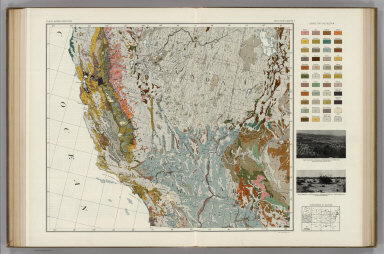
Author
Marbut, Curtis F.
Full Title
Soil Map of the United States by Curtis F. Marbut and Associates in the Soil Survery, U.S. Department of Agriculture, F.J. Marschner, Cartographer and Associate in Compilation. 1931. Soils, Plate 5, Section 4. Lith. A. Hoen & Co., Inc. Atlas of American Agriculture.
List No
5797.085
Note
Includes legend of 12 map sections. Includes soils legend for this section and landscape photographs.
Author
Marbut, Curtis F.
Full Title
Soil Map of the United States by Curtis F. Marbut and Associates in the Soil Survery, U.S. Department of Agriculture, F.J. Marschner, Cartographer and Associate in Compilation. 1931. Soils, Plate 5, Section 5. Lith. A. Hoen & Co., Inc. Atlas of American Agriculture.
List No
5797.091
Note
Includes legend of 12 map sections. Includes soils legend for this section and landscape photographs.
Author
[Rand McNally and Company, State Farm Insurance Companies Travel Bureau]
Full Title
Rand McNally Road map: California. Copyright by Rand McNally & Company, Chicago, Ill. Lithorgaphed in the U.S.A. U.3629. (to accompany) State Farm road atlas : United States, Canada, Mexico.
List No
6825.019
Note
Color map. U.S. interstate highways shown in red. Shows time zone boundaries, roads, ferries, highways, rivers and streams. Includes population of cities and towns. Relief shown by hachures.
Author
Mitchell, Samuel Augustus
Full Title
A New Map of the States of California, the Territories of Oregon, Washington, Utah & New Mexico : Published By Charles Desilver, No. 714 Chestnut St. Philadelphia. 37. Entered ... 1859, by Charles Desilver ... Pennsylvania. (to accompany) A New Universal Atlas Containing Maps of the various Empires, Kingdoms, States and Republics Of The World.
List No
8065.039
Note
Colored by county. Prime Meridians are Washington and Greenwich. Relief shown by hachures. Shows capitals, routes of Pacific Railroad, roads, military and trading posts, major cities and towns. Shows tribes of Native Americans.
1-38 of 38
|