|
Author
Arrowsmith, John, 1790-1873
Full Title
Map of Texas, compiled from Surveys recorded in the Land Office of Texas, and other Official Surveys, by John Arrowsmith. Soho Square, London. London Pubd. 8th June, 1858, by John Arrowsmith. 10 Soho Square.
List No
14506.117
Note
Map representing Texas, United States of America. Shows political boundaries, topography, cities, roads, bodies of water, drainage, coastlines, and islands. Relief shown with hachures. Includes latitudinal and longitudinal lines, as well as a bar scale given in English miles. With inset map: Plan of Galveston Bay from a M.S. With ancillary map: [Western United States and Mexico]. Map is 62 x 51 cm, on double sheet 68 x 56 cm.
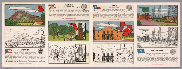
Author
[Fisher, Joseph R., Planters Peanuts (Firm)]
Full Title
Georgia : The empire state of the south -- Florida : The peninsula state -- Texas : The lone star state -- Oklahoma : The sooner state.
List No
14374.007
Note
Four views, representing Georgia, Florida, Texas and Oklahoma. Views show examples of the landscape and natural resources. Each view includes an inset map of the state, which marks the location of the capital city with a star. Accompanied by descriptive text, the state flags, seals and flowers: Cherokee rose, orange blossom, bluebonnet and mistletoe, respectively. The view of each state appears both in color (on top) and in black and white (bottom), the latter inviting coloration. Together, views are 18 x 52 cm, on two sheets 20 x 54 cm.
Author
Cram, George Franklin, 1841-1928
Full Title
Railroad and county map of Texas. Geo. F. Cram, engraver and publisher, Chicago.
List No
14250.053
Note
Map of Texas, showing railroads (both finished and unfinished), county boundaries, cities and towns, post offices, drainage and coastline. Political boundary lines in color. Includes a legend and a bar scale. With index numbers along the perimeter, and decorative border. Also, with an inset map: [Northern Texas]. 41 x 55 cm, on sheet 45 x 58 cm.
Author
H.M. Gousha Company
Full Title
1937 road map of Texas. Prepared exclusively for the Standard Oil Company of Texas. Copyright by the H.M. Gousha Company, Chicago, Ill. Printed in U.S.A. 282-S.C. (to accompany) Standard Oil road map. C.J. Moody.
List No
9875.010
Note
Color map, double page. Shows roads, highways, trails, state parks, monuments, national forests, airports, drainage, distances, places of interest, etc. Includes legend and index to cities and towns. Includes RPM Motor Oil logo. Relief shown by hachures and spot heights.
Author
[Berghaus, Heinrich, 1797-1884, Sohr, Karl, Flemming, Carl]
Full Title
Texas. Druck u. Verlag v. C. Flemming in Glogau. (to accompany) Vollstandiger Universal-Handatlas der neueren Erdbeschreibung ,,, Heinrich Berghaus ... 1859.
List No
13250.129
Note
Hand colored in outline map, with inset" Plan der Galveston Bay. Relief shown by hachures. Prime meridians are Paris and Ferro.
Author
[Meyer, Joseph, 1796-1856, Grassl, J.]
Full Title
Vereinigte Staaten von Nord-America : Californien, Texas und die Territorien New Mexico u. Utah. Nach den neuesten Hulfsmitteln gezeich von J. Grassl. 1852. (in upper margin) Meyer's Zeitung Atlas. No. 120. (to accompany) Neuester Zeitungs-Atlas fur Alte und Neue Erdkunde. Herausgegeben von J. Meyer.
List No
11652.098
Note
Engraved outline hand color map. Shows administrative boundaries, cities and towns, the gold region in California, Texas truncated by an enlarged New Mexico. Relief shown by hachures. Depth shown by isolines. Prime meridians are Greenwich and Washington.
Author
Rand, McNally & Co.
Full Title
Texas.
List No
9733.145
Author
[Sohr, Karl, Flemming, Carl]
Full Title
Mexico, Mittel America, Texas.
List No
5200.071
Author
Appleton, D. & Co.
Full Title
Map of Texas, Oklahoma and Indian Territory. Copyright 1891 by Matthews-Northrup Co. ... Buffalo, New York. (inset) Western part of Texas. (to accompany) The Library Atlas Of Modern Geography ... New York, D. Appleton And Company 1892. (on upper margin) Texas, Oklahoma and Indian Territory 98.
List No
0026.250
Note
Color map. Shows state and county boundaries and county seat, capital, Indian Reservations, railways, roads, rivers, etc. "Size of type indicates importance of the places". Includes notes. Prime meridians are Greenwich and Washington. Relief shown by hachures.
Author
Arbuckle Bros.
Full Title
Indian Territory, New Mexico, South Dakota, Texas. Copyright 1889 Arbuckle Bros. N.Y.
List No
0027.005
Note
Sheet with maps of four states in full color. "Indian Territory" is now known as Oklahoma. It is noted that, "Of the 41,000,000 acres in the Territory, nearly 26,000,000 have been surveyed and set apart as reservations for the Indians. These have been gathered from all parts of the country, from Oregon to Florida, in pursuance of the general plan of congregating all the Indians in one territory, to be theirs forever." Each card measures 7.5 x 12.5 cm.
Author
Asher & Adams
Full Title
Asher & Adams' Indian Territory and Texas north west portion. Entered according to Act of Congress in the year 1874 by Asher & Adams ... at Washington. (New York, 1874)
List No
0041.015
Note
Hand col. engraved map. Easternmost Indian Territory shown on pages 51-52 of this atlas. Shows townships, distances along railroads, etc. Prime meridians: Greenwich and Washington.
Author
Asher & Adams
Full Title
Asher & Adams' Texas eastern portion. Entered according to Act of Congress in the year 1874 by Asher & Adams ... at Washington. (New York, 1874)
List No
0041.016
Note
Hand col. engraved map. Includes inset map. Shows distances along railroads, etc. Prime meridians: Greenwich and Washington.
Author
Asher & Adams
Full Title
Asher & Adams' Texas western portion. Entered according to Act of Congress in the year 1874 by Asher & Adams ... at Washington. (New York, 1874)
List No
0041.017
Note
Hand col. engraved map. Includes inset map. Prime meridians: Greenwich and Washington.
Author
[Bartholomew, John, Black, Adam & Charles]
Full Title
Texas, Part of New Mexico. Published by A. & C. Black. Edinburgh. Printed in Colours by Schenck & Macfariane. Edinburgh. Drawn & Engraved by J. Bartholomew, Edinburgh.
List No
0073.017
Note
States outlined in color. Land tinted.
Author
[Bartholomew, John, Black, Adam & Charles]
Full Title
Western States, including California, Oregon, Utah, Washington, New Mexico, Nebraska, Kansas, Indian Territory, &c. Published by A. & C. Black. Edinburgh. Printed in Colours by Schenck & Macfariane. Edinburgh. Drawn & Engraved by J. Bartholomew, Edinburgh.
List No
0073.018
Note
States outlined in color. Land tinted.
Author
Bradford, Thomas G.
Full Title
Texas. Entered ... 1838, by T.G. Bradford ... Massachusetts. Engraved by G.W. Boynton.
List No
0089.038
Note
In full color.
Author
[Carey, H. C., Humboldt, Alexander von, 1769-1859, Lea, I.]
Full Title
Geographical, Historical, And Statistical Map Of Mexico. Mexico And Internal Provinces. No. 38. Prepared from Humboldt's Map & other Documents by J. Finlayson. Engrav'd by Young & Delleker.
List No
0122.033
Note
In full color by region surrounded by text.
Author
Colton, G.W.
Full Title
Texas. (with) two inset maps: Plan of Galveston Bay From the U.S. Coast Survey and Plan of Sabine Lake. Published By J.H. Colton & Co. No. 172 William St. New York. Entered ... 1855 by J.H. Colton & Co. ... New York. No. 35.
List No
0149.041
Note
In full color by county or region. Proposed railroad routes and known topographical features of western Texas shown.
Author
Colton, G.W.
Full Title
Colton's New Map of the State of Texas. Complied from J. D. Cordova's Large Map. (inset) Plan of the Northern Part of Texas. Plan of Galveston Bay. Plan of Sabine Lake. Published By J. H. Colton. No. 172 William St. New York.
List No
0151.047
Note
Map showing the county boundaries in color. Prime meridians are Greenwich and Washington D.C.
Author
Colton, G.W.
Full Title
Colton's New Map of the State of Texas. Complied from J. D. Cordova's Large Map. (inset) Plan of the Northern Part of Texas. Plan of Galveston Bay. Plan of Sabine Lake. Published By G. W & C. B. Colton & Co. No. 172 William St. New York.
List No
0152.046
Note
Prime meridians are Washington D.C. and Greenwich.
Author
Cornell, S. S. (Sarah S.)
Full Title
Texas. (with) California. Drawn by E. Wells, N.Y. Entered ... 1856, by S.S. Cornell ... Southern District of New York. New York: D. Appleton & Co., 443 & 445 Broadway. (1864)
List No
0197.015
Note
Engraved map with inset. Hand colored. Relief shown by hachures. California map also covers western Oregon. Prime meridians: Greenwich and Washington. "Reference map."
Author
Cram, George Franklin
Full Title
Texas.
List No
0210.036
Note
Prime meridians Greenwich and Washington.
Author
Finley, Anthony
Full Title
Mexico. Published by A. Finley Philada. Young & Delleker Sc.
List No
0285.032
Note
Full color by state.
Author
Gray, O.W.
Full Title
Gray's Atlas Map of Texas.
List No
0310.057
Author
[Gray, Frank A., Gray, O.W.]
Full Title
Gray's Map of Texas and the Indian Territory by Frank A. Gray. Copyright 1876 by O.W. Gray & Son. (insets) Hypsometric Sketch of Texas and the Indian Territory. Austin. Matagorda Bay. The City of Galveston. Entrance to Galveston Bay. The River Systems if Texas and the Indian Territory.
List No
0312.030
Author
Johnson, A.J.
Full Title
Johnson's New Map of the State of Texas By Johnson and Ward. (inset) Plan Of Galveston Bay From The U.S. Coast Survey. (inset) Plan of Sabine Lake. (inset) Plan of the Northern Part of Texas.
List No
0352.033
Note
Full color by county, with heavy outlines around the state. Prime meridians are Greenwich and Washington D.C. Relief shown by hachures.
Author
Johnson, A.J.
Full Title
Johnson's Texas. (insets) Plan of Galveston Bay and Vicinity; Northern Part of Texas. Entered ... 1866.
List No
0358.038
Author
Lizars, William Home, 1788-1859
Full Title
United States & Texas. With all the railways and canals. Published by W. Lizars, Edinburgh. (to accompany) Lizars' Edinburgh Geographical General Atlas ... 1841.
List No
0438.074
Note
Double page engraved hand colored in outline. Relief shown by hachures. Shows "Republic of Texas," the eastern United States and its western territories, Indian settlements, towns, roads, railroads, rivers, canals and mountains. Prime meridian is Greenwich.
Author
[Martin, R.M., Tallis, J. & F.]
Full Title
Mexico, California and Texas. The Illustrations by H. Warren & Engraved by J. Rogers. The Map Drawn & Engraved by J. Rapkin.
List No
0466.072
Note
Mexico in outline color by county. New or Upper California and Texas shown in outline color. California's "newly discovered GOLD districts" are highlighted in bright yellow following the paths of the R. Sacramento and the Rio San Joaquin. The accompanying illustrations include gold washing, Mexican peasants and the ruins of Uxmal, Yucatan. The decorative border includes vegetation, fruits and vegetables from the region.
Author
Johnson, A.J.
Full Title
Johnson's New Map of the State of Texas by Johnson and Ward. (inset) Plan Of Galveston Bay From The U.S. Coast Survey. (inset) Plan of Sabine Lake. (inset) Plan of the Northern Part of Texas.
List No
0535.031
Note
Map in full color by county or region. Mail routes and topographic information is given in west Texas. Relief shown by hachures. Meridians Greenwich and Washington D.C.
Author
Mitchell, Samuel Augustus
Full Title
Map Of Texas From the most recent authorities. (with) Texas North Of Red River. Philadelphia: Published by C.S. Williams N.E. corner of Market & 7th Streets. Entered ... 1845 by C.S. Williams ... Pennsylvania.
List No
0537.036
Note
In full color by county or region.
Author
Mitchell, Samuel Augustus
Full Title
Map of Texas from the most Recent Authorities. Philadelphia: Published By C.S. Williams, N.E. corner of Market & 7th. Streets. Entered ... 1845 by C.S. Williams ... Pennsylvania. (inset map) Texas North of Red River.
List No
0545.039
Note
Full color map. Prime meridians are Greenwich and Washington D.C. Relief shown by hachures.
Author
Mitchell, Samuel Augustus
Full Title
County Map Of Texas. 29. (with) inset map of Galveston Bay, and Vicinity. 30. Entered ... 1860, by S. Augustus Mitchell, Jr. ... Pennsylvania.
List No
0565.020
Note
Full color by county and territories. Some topographic features included such as the Staked Plain with vegetation and water availability noted.
Author
Mitchell, Samuel Augustus Jr.
Full Title
County map of Texas. (inset map) 35. Galveston Bay and Vicinity. Entered ... 1860 by S. Augustus Mitchell, Jr. ... Pennsylvania.
List No
0572.030
Note
Full color map by county. Relief shown by hachures. Prime meridians are Greenwich and Washington, D.C.
Author
Mitchell, Samuel Augustus Jr.
Full Title
County map of Texas. (inset map) Galveston Bay, and Vicinity. 40. Entered ... 1867 by S. Augustus Mitchell, Jr. ... Pennsylvania.
List No
0579.031
Note
Color map by county. Relief shown by hachures. Prime meridians are Greenwich and Washington, D.C.
Author
Mitchell, Samuel Augustus
Full Title
County map of the state of Texas. Showing also portions of the adjoining states and territories. Drawn and engraved by W.H. Gamble, Philadelphia. (with) Plan of Galveston and vicinity. Entered ... 1879 by S. Augustus Mitchell ... Washington. (1880)
List No
0586.029
Note
Hand colored map with inset. Relief shown by hachures. Shows settlements, railroads, etc. Covers also parts of New Mexico and Indian Territory. Prime meridians: Greenwich and Washington.
Author
Mitchell, Samuel Augustus Jr.
Full Title
County map of the state of Texas. Showing also portions of the adjoining states and territories. (with) Plan of Galveston and vicinity. Copyright by S. Augustus Mitchell 1884.
List No
0592.031
Note
Hand colored map with inset. Relief shown by hachures. Shows settlements, railroads, etc. Covers also parts of New Mexico and Indian Territory. Prime meridians: Greenwich and Washington.
Full Title
County map of the state of Texas. Showing also portions of the adjoining states and territories. (with) Plan of Galveston and vicinity. Copyright 1887 by Wm. M. Bradley & Bro. (1890)
List No
0594.030
Note
Hand colored map with inset. Relief shown by hachures. Shows settlements, railroads, etc. Covers also parts of New Mexico and Indian Territory. Prime meridians: Greenwich and Washington.
Author
[Morse, Charles W., Colby, Charles A.]
Full Title
Texas.
List No
0623.030
Author
[Scovel, James L., O'Brien, Emmett J]
Full Title
Streams. Delta. new Orleans, La.-Tex.
List No
0889.055
Note
Color maps with text, and location map.
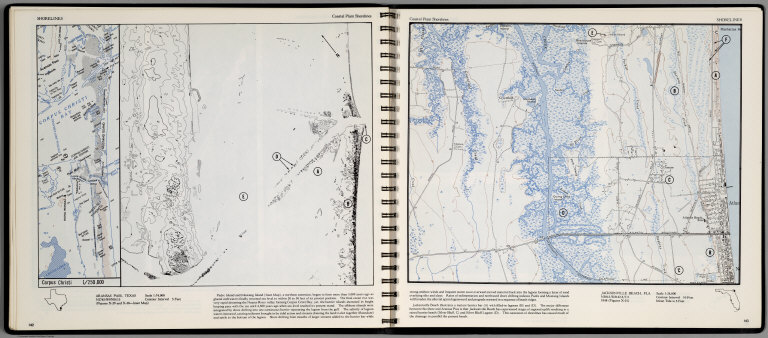
Author
[Scovel, James L., O'Brien, Emmett J]
Full Title
Shorelines. Coastal Plain Shorlines. Aransas Pass, Texas. (inset map) Corpus Christi. (on opposite page) Jacksonville Beach, Fla. Scale 1:24,000..
List No
0889.075
Note
Contour color maps, with location map and text. Relief shown by contours and spot heights.
Author
[Stieler, Adolf, Petermann, A.]
Full Title
Stieler's Hand-Atlas ... No. 85. Petermann: Vereinigte Staaten von Nord-Amerika in 6 Blattern, Bl.5.
List No
0960.102
Author
[Stieler, Adolf, Petermann, A.]
Full Title
Stieler's Hand-Atlas ... No. 86. Petermann: Vereinigte Staaten von Nord-Amerika in 6 Blattern, Bl.6. (inset) Florida. Texas.
List No
0960.103
Author
Tanner, Henry S.
Full Title
Mexico & Guatemala: By H.S. Tanner. (with) two inset maps: Guatemala and Valley of Mexico. Engraved by J. Knight. Entered ... 1834 by H.S. Tanner ... Pennsylvania. Philadelphia Published by H.S. Tanner. (above neat line) Tanner's Universal Atlas.
List No
0977.031
Note
In full color by region.
Author
Tanner, Henry S.
Full Title
Texas.
List No
0980.039
Author
[Martin, R.M., Tallis, J. & F.]
Full Title
Mexico, California and Texas. The Illustrations by H. Warren & Engraved by J. Rogers. The Map Drawn & Engraved by J. Rapkin.
List No
10095.073
Note
Mexico in outline color by county. New or Upper California and Texas shown in outline color. California's "newly discovered GOLD districts" are highlighted in bright yellow following the paths of the R. Sacramento and the Rio San Joaquin. The accompanying illustrations include gold washing, Mexican peasants and the ruins of Uxmal, Yucatan. The decorative border includes vegetation, fruits and vegetables from the region.
Author
[Touring club italiano, Funk & Wagnalls Company.]
Full Title
Stati Uniti, United States of America, New Mexico, Oklahoma, Texas. (with New Orleans-Mississippi Delta region). Propr. Artistico-letteraria del T.C.I. Ufficio cartografico del T.C.I. (1929)
List No
1012.077
Note
Color map. Relief shown by hachures and spot heights; depths by isolines. Inset at 1:750,000 scale.
Author
[Wytfliet, Corneille, Magini, Giovanni Antonio]
Full Title
Hispania Nova. (to accompany) Histoire universelle des Indes occidentales et orientales, et de la conversion des Indiens : divisee en trois parties par Cornille Wytfliet & Anthoine Magin & autres historiens. Premiere Partie. A Douay, Chez Francois Fabri, l'An 1611.
List No
11622.045
Note
Uncolored engraved double page map of Mexico and part of Florida and present-day Texas. Includes decorative title cartouche. Shows cities, towns, landmarks, rivers and mountains. Relief shown pictorially.
Author
[Ewald, Ludwig 1813-1881, Bauerkeller, Georg Leonhart]
Full Title
No. 74. Mexico und Texas.
List No
12189.108
Author
[Handtke, F., Flemming, Carl, Sohr, Karl]
Full Title
Texas.
List No
12206.088
|