|
REFINE
Browse All : Atlas Map of New Haven (Conn.)
1-15 of 15
Author
[Ford Motor Company, Geological Survey (U.S.). Topographic Branch]
Full Title
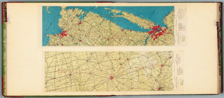
Air navigation map [5] (experimental) : Dayton, Ohio to Rantoul, Ill. Prepared under the direction of the Airways Section Office of the Chief of Air Service by the Topographic Branch, U.S. Geological Survey, 1924. Engineer Reproduction Plant, U.S. Army, Washington Barracks, D.C. 1926, 4915-5. -- Air navigation map no. 6 (experimental) : New York, N.Y. to Boston, Mass. Prepared under the direction of the Airways Section Office of the Chief of Air Corps by the Topographic Branch, U.S. Geological Survey, 1924. Engineer Reproduction Plant, U.S. Army, Washington Barracks, D.C. 4915-6, 1924 - R-1927.
List No
14501.005
Note
Two aeronautical charts representing the areas from Dayton, Ohio to Rantoul, Illinois, and from New York, New York, to Boston, Massachusetts. Features military, municipal, commercial, emergency, and seaplane landing fields, as well as beacon lights. Also shows political boundaries, roads, railways, cities, towns, topography, bodies of water, and drainage. Relief shown with contour lines and color coding. Maps include latitudinal and longitudinal lines, legend, scale statements, and bar scales given in miles, as well as compass roses oriented toward top of sheet (with slight variation between the two maps). Color lithographs. Together, maps are 56 x 92 cm, on double sheet, 60 x 136 cm. Map number 5 provided with a handwritten annotation.
Full Title
South part of city of New Haven, town of New Haven. (Copyright 1893 by D.H. Hurd & Co.)
List No
0332.037
Note
Hand col. lithographed map. Shows wards, streets, railroads, major buildings, cemeteries, parks, etc. North part on p. 70-71; east part on p. 74-75.
Full Title
North part of city of New Haven, town of New Haven. (Copyright 1893 by D.H. Hurd & Co.)
List No
0332.039
Note
Hand col. lithographed map. Shows wards, streets, railroads, major buildings, cemetery, parks, etc. South part on p. 66-67; east part on p. 74-75.
Full Title
East part of city of New Haven, Fairhaven. (with) East Rock Park, New Haven County, Oxford, town of Oxford, county of New Haven. (Copyright 1893 by D.H. Hurd & Co.)
List No
0332.041
Note
Hand col. lithographed map with inset. Shows wards, streets, railroads, major buildings, cemetery, park, etc. North part on p. 70-71; South part on p. 66-67.
Full Title
Ward 15, town of New Haven. (with) Stony Creek, town of Branford, New Haven County. (with) Short Beach, town of Branford, New Haven County. (with) Yalesville, town of Wallingford, county of New Haven. (Copyright 1893 by D.H. Hurd & Co.)
List No
0332.049
Note
Hand col. lithographed map with 3 insets. Shows streets, trolley line, major buildings, parks, etc.
Author
Tanner, Henry S.
Full Title
Connecticut By H.S. Tanner. Engraved by E.B. Dawson. (with) two inset maps Hartford &c. and New Haven &c. Entered ... 1834 by H.S. Tanner ... Pennsylvania. Philadelphia: Published by H.S. Tanner. (above neat line) Tanner's Universal Atlas.
List No
0977.009
Note
In full color by county with railroads in blue and canals in red. Statistical table with county and town population and population figures from 1701-1830.
Author
[Nirenstein, Nathan, Bowers, M.L.]
Full Title
Business Section, City of New Haven (Connecticut).
List No
12504.076
Author
Cram, George Franklin, 1841-1928
Full Title
Map of the city of New Haven.
List No
14372.209
Note
Map of New Haven, Connecticut. Shows railroads, streets, parks, hills, bodies of water, drainage, coastlines and islands. Includes circles of distance from the city center, given in miles. Colored lithograph. Map is 38 x 27 cm, on sheet 45 x 33 cm.
Author
[Bache, A. D., Hassler, F. R.]
Full Title
New Haven Harbor. Founded upon a trigonometrical survey under the direction of F.R. Hassler, Superintendent of the Survey of the Coast of the United States. Triangulation by James Ferguson and Edmund Blunt, assistants. Topography by C.M. Eakin, W.M. Boyce & J. Farley, assistants. Hydrography by the party under the command of G.S. Blake, Lieut., U.S. Navy. Published in 1846. A.D. Bache, Superintendent. Final reduction for engraving by Jno. B. Gluck, draughtsman. Engraved by Sherman & Smith, N.Y. Electrotype copy no. 3 by S. Siebert, U.S.C.S. (with logo) U.S. Coast Survey Depot.
List No
2470.013
Note
Engraved nautical chart. Relief shown by hachures; depths by soundings. Includes sailing directions and descriptive information. In upper margin "Presented under authority of an act of Congress of the United States of June 3d 1844 by direction of the Treasury Department, A.D. Bache Superintendent Coast Survey."
Author
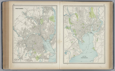
Cram, George Franklin
Full Title
Providence. New Haven.
List No
2809.088
Author
Mitchell, Samuel Augustus
Full Title
Map of Connecticut. Published by Thomas, Cowperthwait & Co. No. 253 Market Street, Philadelphia. Entered ... 1850 by Thomas, Cowperthwait & Co. ... Pennsylvania. (with two inset maps) Hartford &c., and New haven &c.
List No
4328.013
Note
Full color map by county. Shows railroads, roads, church, tavern, capital, etc. With lists of counties with population at different periods. Relief shown by hachures. Prime meridian is Washington.
Author
Mitchell, Samuel Augustus
Full Title
Map of Connecticut. Philadelphia, Published By Charles Desilver, No. 714 Chestnut Street. Entered according to Act of Congress in the year 1856 by Charles Desilver in the Clerk's office if the District Court of the Eastern District of Pennsylvania. 10.
List No
4557.011
Note
Counties tinted in color. Insets of Hartford &c. and New Haven &c. Meridian Washington. Population table. Relief shown by hachures.
Author
[Bourquin, Frederick, Mitchell, Samuel Augustus, Tanner, Henry S.]
Full Title
Connecticut. Entered according to Act of Congress in the 1839, by H.S. Tanner, - in the Clerk's Office of the District Court of the Eastern District of Pennsylvania. 9.
List No
4578.010
Note
Lithographed. Relief shown with hachures. Meridian Washington. Canals, railroads, and roads shown. Inset historic population tables. Insets of Hartford and New Haven.
Author
Tanner, Henry S.
Full Title
Connecticut By H.S. Tanner. Engraved by E.B. Dawson. (with) two inset maps Hartford &c. and New Haven &c. Entered ... 1839 by H.S. Tanner ... Pennsylvania. Philadelphia: Published by Carey & Hart Philadelphia. (above neat line) Tanner's Universal Atlas.
List No
5363.010
Note
In full color by county with railroads in blue and canals in red. Statistical table with county and town population and population figure Engraved. Relief shown by hachures. Meridian Washington.
Author
Mitchell, Samuel Augustus
Full Title
Map of Connecticut. Philadelphia, Published By Charles Desilver, No. 714 Chesnut Street. Entered according to Act of Congress in the year 1856 by Charles Desilver in the Clerk's office if the District Court of the Eastern District of Pennsylvania. 10.
List No
6727.013
Note
Counties tinted in color. Insets of Hartford &c. and New Haven &c. Meridian Washington. Population table. Relief shown by hachures.
1-15 of 15
|