|
Author
[Fisher, Joseph R., Planters Peanuts (Firm)]
Full Title
Louisiana : The pelican state -- Arkansas : The wonder state -- Alabama : The cotton state -- Mississippi : The magnolia state.
List No
14374.012
Note
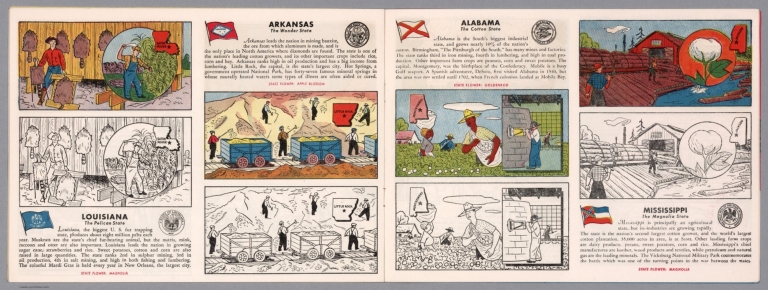
Four views, representing Louisiana, Arkansas, Alabama and Mississippi. Views show examples of the landscape and natural resources. Each view includes an inset map of the state, which marks the location of the capital city with a star. Accompanied by descriptive text, the state flags, seals and flowers: magnolia, apple blossom, goldenrod and magnolia, respectively. The view of each state appears both in color (on top) and in black and white (bottom), the latter inviting coloration. Together, views are 18 x 52 cm, on two sheets 20 x 54 cm.
Author
Cram, George Franklin, 1841-1928
Full Title
Cram's railroad and township map of Louisiana. Published by Geo. F. Cram, proprietor of the Western Map Depot. 262-264, Wabash, Ave. Chicago Ills. 1882
List No
14250.048
Note
Map of Louisiana, showing railroads, county boundaries, cities and towns, drainage and coastline. Political boundary lines in color. Includes a bar scale and a scale statement: Scale 18 miles to an inch. With index numbers along the perimeter, and decorative border. 51 x 42 cm, on sheet 58 x 45 cm.
Author
Appleton, D. & Co.
Full Title
Map of Louisiana. Copyright 1891 by Matthews-Northrup Co. ... Buffalo, New York. (inset) Map of New Orleans. (to accompany) The Library Atlas Of Modern Geography ... New York, D. Appleton And Company 1892. (on upper margin) Louisiana. 67.
List No
0026.177
Note
Color map. Shows county boundaries and county seat, capital, rivers, railways, roads, etc. "Size of type indicates importance of the places". Includes notes. Prime meridians are Greenwich and Washington.
Author
Appleton, D. & Co.
Full Title
Map of New Orleans, Louisiana. Copyright 1891 by Matthews-Northrup Co. ... Buffalo, New York. (to accompany) The Library Atlas Of Modern Geography ... New York, D. Appleton And Company 1892. (on upper margin) New Orleans. 69.
List No
0026.183
Note
Color plan of New Orleans. Shows railways, street car lines, parks, canals, etc. Includes numerical references to Depots, hotels, churches, major buildings, points of interest, parks and cemeteries.
Author
Arbuckle Bros.
Full Title
Territory of Wyoming, Alabama, Louisiana, Kansas. Copyright 1889 Arbuckle Bros. N.Y.
List No
0027.011
Note
Sheet with maps of four states in full color. Wyoming's information includes a long paragraph on Yellowstone National Park, which is noted on the card as well. It is mentioned that in Louisiana, yellow fever epidemics swept through the state in 1853, 1867 and 1878. Each card measures 7.5 x 12.5 cm.
Author
Asher & Adams
Full Title
Asher & Adams' Louisiana and Mississippi. Entered according to Act of Congress in the year 1874 by Asher & Adams ... at Washington. (New York, 1874)
List No
0041.013
Note
Hand col. engraved map. Shows townships, distances along railroads, etc. Prime meridians: Greenwich and Washington.
Author
[Bartholomew, John, Black, Adam & Charles]
Full Title
Mississippi & Lousiana. Published by A. & C. Black. Edinburgh. Printed in Colours by Schenck & Macfariane. Edinburgh. Drawn & Engraved by J. Bartholomew, Edinburgh.
List No
0073.016
Note
States outlined in color. Land tinted.
Author
Bradford, Thomas G.
Full Title
Washington. Louisville and Jeffersonville. New Orleans. Cincinnati. Entered ... 1838, by T.G. Bradford ... Massachusetts.
List No
0089.006
Note
Four city maps in full color. The map of Washington includes numbered locations including the Capitol, the State Department, Departments of War, Navy, and the Treasury, as well as the General Post Office.
Author
Bradford, Thomas G.
Full Title
Louisiana. Entered ... 1838, by T.G. Bradford ... Massachusetts. Engraved by G.W. Boynton.
List No
0089.034
Note
In full color.
Full Title
Carte geographique, statistique et historique de la Louisiane. Louisiane. Grave par B. de Beaupre, Rue de Vaugirard, no. 81, a Paris. Fonderie et Imprimerie de J. Carez. (1825)
List No
0102.031
Note
Hand colored engraved map. Relief shown by hachures. Text and tables at sides and bottom. Prime meridians: Washington and Paris.
Author
Burr, David H., 1803-1875
Full Title
Map of Mississippi, Louisiana & Arkansas Exhibiting the Post Offices, Post Roads, Canals, Rail Roads, &c. By David H. Burr. (Late Topographer to the Post Office.) Geographer to the House of Representatives of the U.S. John Arrowsmith. Entered ... July 10th, 1839, by David H. Burr ... District of Columbia.
List No
0104.009
Note
In full color by county. Postal routes by coach, stage, sulkey, cross, rail roads and canals shown. In 8 sections mounted on linen. Label on back states "No. 9. Mississippi, Louisiana, Arkansas."
Author
[Carey, H. C., Lea, I.]
Full Title
Geographical, Historical, And Statistical Map Of Louisiana. Louisiana. No. 31. Kneass Sc.
List No
0122.026
Note
In full color by county or region surrounded by text.
Author
Colton, G.W.
Full Title
Louisiana. Published By J.H. Colton & Co. No. 172 William St. New York. Entered ... 1854 by J.H. Colton ... New York. No. 33.
List No
0149.039
Note
In full color by county.
Author
Colton, G.W.
Full Title
The City Of Louisville Kentucky. (with) The City Of New Orleans Louisiana. Published By J.H. Colton & Co. No. 172 William St. New York. Entered ... 1855 by J.H. Colton & Co. ... New York. No. 34.
List No
0149.040
Note
In full color. Both cities numbered with no reference tables. The two maps are separate but surrounded by the same decorative border.
Author
Colton, G.W.
Full Title
Colton's Louisiana. Published By J. H. Colton. No. 172 William St. New York.
List No
0151.045
Note
Map showing the county boundaries in color. Prime meridians are Greenwich and Washington D.C.
Author
Colton, G.W.
Full Title
Colton's Louisiana. Published By G. W & C. B. Colton & Co. No. 172 William St. New York.
List No
0152.044
Note
Prime meridians are Washington D.C. and Greenwich.
Author
Colton, G.W.
Full Title
The City of Louisville, Kentucky. The City of New Orleans, Louisiana. Published By J. H. Colton. No. 172 William St. New York.
List No
0152.045
Note
The maps of Louisville & New Orleans are drawn upon the same scale.
Author
Cram, George Franklin
Full Title
New Rail Road and County Map of Arkansas, Louisiana, & Mississippi.
List No
0210.034
Note
Prime meridians Greenwich and Washington.
Author
Finley, Anthony
Full Title
Map of Louisiana Mississippi And Alabama Constructed from the Latest Authorities. D.H. Vance Del. J.H. Young Sc. Philadelphia Published by A. Finley 1826.
List No
0278.009
Note
In full color by county. Statistical information includes state size, population, and number of people in different jobs (agriculture, manufacturing, commerce and militia).
Author
Finley, Anthony
Full Title
Map of Louisiana, Mississippi, and Alabama, Constructed from the Latest Authorities.
List No
0279.013
Author
Finley, Anthony
Full Title
Map of Louisiana, Mississippi, and Alabama. Constructed from the Latest Authorities. D.H. Vance Del., Philadelphia Published by A. Finley 1827. J.H. Young Sc.
List No
0280.009
Note
Relief shown by hachures. Prime meridian Washington. Statistical table for each state. Marshlands along Gulf of Mexico well shown.
Author
Finley, Anthony
Full Title
Louisiana. Young & Delleker Sc. Published by A. Finley, Philada. (to accompany) A New General Atlas Comprising a Complete Set of Maps, representing the Grand Divisions Of The Globe ... Philadelphia: Published by Anthony Finley. 1827.
List No
0282.033
Note
Full color map on sheet 35x27. Prime meridians are Washington and Greenwich. Shows counties, major cities, roads and rivers.
Author
Finley, Anthony
Full Title
Louisiana. Published by A. Finley Philada. Young & Delleker Sc.
List No
0285.029
Note
Full color by county.
Author
Gray, O.W.
Full Title
Gray's Atlas Map of Louisiana.
List No
0310.055
Author
[Gray, Frank A., Gray, O.W.]
Full Title
Gray's New Map of Louisiana by Frank A. Gray. Copyright 1878 by O.W. Gray & Son. (insets) City of New Orleans. The Passes of the Mississippi River.
List No
0312.029
Full Title
Alabama, Mississippi, Louisiana & Arkansas Ter. J.H. Young Sc. (Philadelphia: John Grigg, No. 9 North Fourth Street. 1830)
List No
0315.008
Note
Engraved map. Full hand color. Relief shown pictorially. Prime meridians: Greenwich and Washington. "XXXIII."
Author
Johnson, A.J.
Full Title
Johnson's Arkansas, Mississippi, And Louisiana By Johnson and Ward.
List No
0352.032
Note
Full color by county, with heavy outlines around the state. Prime meridians are Greenwich and Washington D.C. Relief shown by hachures.
Author
Johnson, A.J.
Full Title
Johnson's Arkansas, Mississippi, and Louisiana. Entered ... 1866.
List No
0358.037
Author
Johnson, A.J.
Full Title
Johnson's Arkansas, Mississippi, And Louisiana By Johnson and Ward.
List No
0535.030
Note
In full color by county. Relief shown by hachures. Meridians Greenwich and Washington D.C.
Author
Mitchell, Samuel Augustus
Full Title
A New Map Of Louisiana With Its Canals, Roads & Distances from place to place, along the Stage & Steam Boat Routes. (with) New Orleans. Published By S. Augustus Mitchell, N.E. corner of Market & 7th Street Philada., 1846. Entered ... 1846 by H.N. Burroughs ... Pennsylvania.
List No
0537.025
Note
In full color by county with steamboat route distances given.
Author
Mitchell, Samuel Augustus
Full Title
A New Map of Louisiana with its Canals, Roads & Distances from Place to Place along the Stage & Steam Boat Routes. Published By S. Augustus Mitchell. N.E. corner of Market & 7th. Streets. Philada. (inset map) New Orleans.
List No
0545.028
Note
Full color map. Includes explanation chart, and reference to steam boat routes. Prime meridian is Washington D.C. Relief shown by hachures.
Author
Mitchell, Samuel Augustus
Full Title
County Map Of Louisiana, Mississippi, And Arkansas. 28. Entered ... 1860, by S. Augustus Mitchell, Jr. ... Pennsylvania.
List No
0565.019
Note
In full color by county.
Author
Mitchell, Samuel Augustus Jr.
Full Title
Map of Louisiana, Mississippi. And Arkansas. Entered ... 1860 by S. Augustus Mitchell, Jr. ... Pennsylvania.
List No
0572.028
Note
Full color map, showing three states by outline color. Prime meridians are Greenwich and Washington, D.C.
Author
Mitchell, Samuel Augustus Jr.
Full Title
Plan of New Orleans. Entered ... 1860 by S. Augustus Mitchell, Jr. ... Pennsylvania.
List No
0572.029
Note
Full color map.
Author
Mitchell, Samuel Augustus Jr.
Full Title
County map of the States of Arkansas, Mississippi and Louisiana. Drawn and Engraved by W.H. Gamble Philadelphia. Entered ... 1867 by S. Augustus Mitchell, Jr. ... Pennsylvania.
List No
0579.029
Note
Color map by county. Relief shown by hachures. Prime meridians are Greenwich and Washington, D.C.
Author
Mitchell, Samuel Augustus Jr.
Full Title
Plan of New Orleans. Entered ... 1867 by S. Augustus Mitchell, Jr. ... Pennsylvania.
List No
0579.030
Note
Color map, showing roads, railroads, etc.
Author
Mitchell, Samuel Augustus
Full Title
County map of the states of Arkansas, Mississippi and Louisiana. Drawn and engraved by W.H. Gamble, Philadelphia. Entered ... 1879 by S. Augustus Mitchell ... Washington. (1880)
List No
0586.027
Note
Hand colored. Relief shown by hachures. Shows settlements, railroads, rivers, etc. Prime meridians: Greenwich and Washington.
Author
Mitchell, Samuel Augustus
Full Title
Plan of New Orleans. Entered ... 1879 by S. Augustus Mitchell ... Washington. (1880)
List No
0586.028
Note
Hand colored. Shows wards, canals, etc. Oriented with north toward upper right.
Author
Mitchell, Samuel Augustus Jr.
Full Title
County map of the states of Arkansas, Mississippi and Louisiana. Drawn and engraved by W.H. Gamble, Sc. Philadelphia. Copyright by S. Augustus Mitchell 1884.
List No
0592.029
Note
Hand colored. Relief shown by hachures. Shows settlements, railroads, rivers, etc. Prime meridians: Greenwich and Washington.
Author
Mitchell, Samuel Augustus Jr.
Full Title
Plan of New Orleans. Copyright by S. Augustus Mitchell 1884.
List No
0592.030
Note
Hand colored. Shows wards, canals, etc. Oriented with north toward upper right.
Full Title
County map of the states of Arkansas, Mississippi and Louisiana. Copyright 1887 by Wm. M. Bradley & Bro. (1890)
List No
0594.028
Note
Hand colored. Relief shown by hachures. Shows settlements, railroads, rivers, etc. Prime meridians: Greenwich and Washington.
Full Title
Plan of New Orleans. Copyright 1887(?) by Wm. M. Bradley & Bro. (1890)
List No
0594.029
Note
Hand colored. Shows wards, canals, etc. Oriented with north toward upper right.
Author
[Morse, Charles W., Colby, Charles A.]
Full Title
Louisiana.
List No
0623.029
Author
[Scovel, James L., O'Brien, Emmett J]
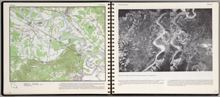
Full Title
Streams. Fully Mature. Campti, La. (on opposite page) Fully Mature Streams. Stereopair of Red River, vicinity of Campti, Louisiana.
List No
0889.048
Note
Contour map, with text, and location maps. Relief shown by contours and spot heights.
Author
[Scovel, James L., O'Brien, Emmett J]
Full Title
Streams. Delta. new Orleans, La.-Tex.
List No
0889.055
Note
Color maps with text, and location map.
Author
Society for the Diffusion of Useful Knowledge (Great Britain)
Full Title
North America sheet XIII. Parts of Louisiana, Arkansas, Mississippi, Alabama & Florida. Published under the superintendence of the Society for the Diffusion of Useful Knowledge. Engraved by J. & C. Walker. Published June 1st. 1833 by Baldwin & Cradock, 47 Paternoster Row, London. (London: Chapman & Hall, 1844)
List No
0890.140
Note
Engraved map. Relief shown by hachures. County boundaries hand col. Source: Tanner.
Author
Tanner, Henry S.
Full Title
A New Map of Louisiana with Its Roads & Distances from place to place along the Stage & Steam Boat Routes by H.S. Tanner. (inset) New Oreleans.
List No
0976.026
Author
Tanner, Henry S.
Full Title
A New Map Of Louisiana With Its Canals, Roads & Distances from place to place, along the Stage & Steam Boat Routes by H.S. Tanner. (with) New Orleans. Engraved by W. Brose, Philadelphia. Entered ... 1833 by H.S. Tanner ... Pennsylvania. Published by H.S. Tanner No. 144 Chesnut St. Philadelphia. (above neat line) Tanner's Universal Atlas.
List No
0977.021
Note
In full color by county with steamboat routes and distances shown in chart form. Inset map of New Orleans includes districts, buildings and cemeteries.
Author
Tanner, Henry S.
Full Title
A New Map of Louisiana with Its Roads & Distances from place to place along the Stage & Steam Boat Routes by H.S. Tanner. (inset) New Oreleans.
List No
0980.026
Author
[Touring club italiano, Funk & Wagnalls Company.]
Full Title
Stati Uniti, United States of America, Arkansas, Tennessee, Louisiana, Mississippi, Florida, Alabama, Georgia, South Carolina. Propr. Artistico-letteraria del T.C.I. Ufficio cartografico del T.C.I. (1929)
List No
1012.078
Note
Color map. Relief shown by hachures and spot heights; depths by isolines. Includes inset of New Orleans at 1:250,000 scale and another that is continuation of main map.
|